Page 1 of 1
Mt. Wilson TR 2/24/09
Posted: Tue Feb 24, 2009 6:26 pm
by Liz
My husband, Gary, and I hiked Mt. Wilson today, via the Upper Winter Creek Trail. We tried Wilson via Sturtevant on 2/14 but turned around when we lost the trail, knee deep in snow. Today was a great day for our hike, except for the haze that gradually collected throughout the day.
We encountered some patches of snow, but not until we were above the section of toll road you have to hike on this trail. Clearly, there was plenty of snow on the road, but it’s been plowed. There was more snow along the last half mile or so of the climb. The snow was crunchy and crusty, a little slippery, but not too bad.
We hiked separately to the top, and together on the descent, as we often do. If you check out my pics, you’ll see what my hubby found me doing at the summit, when he arrived.
All in all, a fine hike on a fine day.
Pics here:
www.flickr.com/photos/33777171@N06/sets ... 402100038/
Re: Mt. Wilson TR 2/24/09
Posted: Tue Feb 24, 2009 11:40 pm
by Sashimi
nice trip report
Re: Mt. Wilson TR 2/24/09
Posted: Wed Feb 25, 2009 9:44 am
by EnFuego
WTF?????? You're reading Backpacker Magazine? If you had time to kill, why didn't you drop and pull off 50 real quit? Or even a hundred?
I'm just teasing. Nice pics and TR. I still need to make it out there with you. That whole area is basically new ground for me. Haven't done much out that way since I was a youngster.
Re: Mt. Wilson TR 2/24/09
Posted: Wed Feb 25, 2009 9:48 am
by Liz
Ha! EnFuego- You were suggesting I pull of 50 or 100 what? Pushups or something? That would be no challenge for me!
This is not the first time I've chilled, while reading, on a summit. I've read atop Baldy, San Gorgonio and now Wilson. This is always when I'm waiting for Gary to join me on a summit. I planned on reading atop Whitney last year, but instead met a bunch of fun guys from the British Army Reserves. I decided to socialize instead! (Get your mind out of the gutter, guys!)
Anyway, whenever you're ready and willing, join me on a Wilson area hike. It has to be before summer, b/c then I'll be back to Baldy, and the San G wilderness.
Re: Mt. Wilson TR 2/24/09
Posted: Wed Feb 25, 2009 9:49 am
by EnFuego
Liz wrote:Ha! EnFuego- You were suggesting I pull of 50 or 100 what? Pushups or something? That would be no challenge for me!
I know it wouldn't be challenging. Thats why I wasn't thinking pushups.

Re: Mt. Wilson TR 2/24/09
Posted: Wed Feb 25, 2009 9:54 am
by Liz
Hmmmm...to what were you referring?
Re: Mt. Wilson TR 2/24/09
Posted: Mon Mar 02, 2009 7:06 am
by RyanB
Hey Liz. I did this hike on 3/1/09 after reading your report. Nice day but a little hot where the trail is exposed. I think it was pushing 90 in the valley. I descended via the Sturtevant trail through Hoeges. This hike totaled 14 miles round trip. I'm a little sore. BTW I took my Backpacker Gear Guide too.
Re: Mt. Wilson TR 2/24/09
Posted: Mon Mar 02, 2009 7:38 am
by Liz
Hey Ryan! I hope you enjoyed the hike, despite the high temps. I've been in the Wilson area a lot this winter in order to avoid a lt of snow. I took a break from that whole idea and hiked in the San Gorgonio Wilderness on 2/28/09. My TR is posted on this site, and wow, what a different kind of day I had.
Well, maybe I'll see ya out on the trail one day.
Re: Mt. Wilson TR 2/24/09
Posted: Mon Mar 02, 2009 8:13 am
by Elwood
I couldn't agree more regarding the pleasant conditions this weekend around Mount Wilson. This is the GPS track from my stroll on Saturday 2/28:
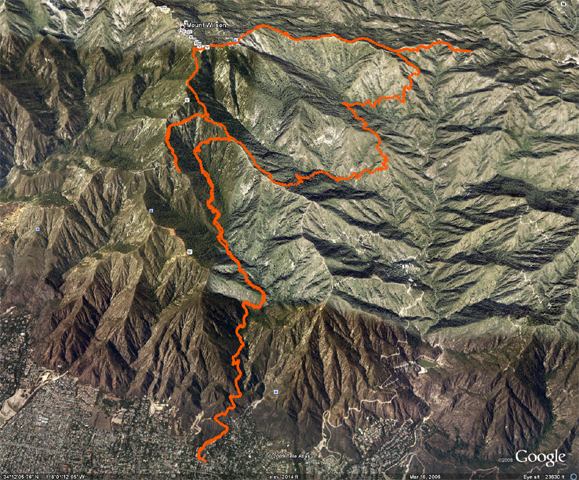
Old Mt. Wilson Trail, Orchard Camp, Winter Creek, Mt. Zion, Sturtevant, Newcomb Pass, Shortcut Saddle, Rim Trail, Wilson "summit", Toll Road, Ridge above Pasadena Glen, brush-bash woos-out turnaround, Mt. Harvard/Wilson trail back to car. Only problem for me was the snow towards the top of the Rim Trail, deep on some fairly exposed spots, and the "Canyon Flies" almost all the way up. I suppose a shower would have helped.
Re: Mt. Wilson TR 2/24/09
Posted: Mon Mar 02, 2009 8:33 am
by EnFuego
Elwood wrote:
Old Mt. Wilson Trail, Orchard Camp, Winter Creek, Mt. Zion, Sturtevant, Newcomb Pass, Shortcut Saddle, Rim Trail, Wilson "summit", Toll Road, Ridge above Pasadena Glen, brush-bash woos-out turnaround, Mt. Harvard/Wilson trail back to car. Only problem for me was the snow towards the top of the Rim Trail, deep on some fairly exposed spots, and the "Canyon Flies" almost all the way up. I suppose a shower would have helped.
Elwood - nice stroll. What's the mileage on your stroll? Are you a high mileage type hiker? I ran into a lot of "canyon flies" myelf this weekend. They sort of "bug" don't they?

Re: Mt. Wilson TR 2/24/09
Posted: Mon Mar 02, 2009 9:27 am
by Elwood
According to the GPS track (sorry guys and gals, no measuring wheel today), this was 26.7 miles with 14,851 feet gained and lost. Long-ish for my Saturday day hikes, but I usually aim for eighteen-or-so miles.
Re: Mt. Wilson TR 2/24/09
Posted: Mon Mar 02, 2009 10:03 am
by AlanK
Elwood wrote:According to the GPS track (sorry guys and gals, no measuring wheel today), this was 26.7 miles with 14,851 feet gained and lost. Long-ish for my Saturday day hikes, but I usually aim for eighteen-or-so miles.
I don't think that measuring wheels are required on this board anymore.

That track looks like a 27 mil hike -- you covered a lot of ground! The elevation gain looks like a GPS glitch. A person could walk up and down Mt. Wilson from Sierra Madre 3 times in a row and gain/lose well under than 14851 feet! You did do a lot of up and down walking, though!
Re: Mt. Wilson TR 2/24/09
Posted: Mon Mar 02, 2009 10:37 am
by RyanB
I agree that the elevation gain/loss seems a little sketchy, but that is some killer mileage for one day! 8)
Re: Mt. Wilson TR 2/24/09
Posted: Mon Mar 02, 2009 10:44 am
by AlanK
RyanB wrote:I agree that the elevation gain/loss seems a little sketchy, but that is some killer mileage for one day! 8)
Yes -- a lot of miles and a lot of hiking downhill, knowing that the loss has to be made up. Those are the tough hikes.