
Ha! That's always my excuse (both to myself and others) "yea, I'm going hiking and camping...but hey, I'm bringing my computer; so I'll get some work done"Hikin_Jim wrote: Dude! You had me right up to the point where you blew it and said the "W" word. (work) We don't use four letter words like that around here.
HJ
Blue Ridge Road (3N06)
-
BrownMtnBob

- Posts: 96
- Joined: Mon Oct 15, 2012 1:55 pm
-
Teejate
- Posts: 107
- Joined: Wed Oct 12, 2011 6:46 pm
They typically close the road based on the weather. From what I heard last week from the Big Pines Ranger Station the road is still open down to Lupine although they said high clearance vehicles are mandatory. I believe they usually close the road in sections starting at Guffy and moving back towards the 2.
But you can camp at either place year round via the Blue Ridge trail up to the campground and PCT or, if the 2 is still open past Wrightwood, you can pick up the PCT at the parking lot.
OR you can have some real fun and hike on the road. The fun there is two crossings of the ski run with a pack on. It's like a live version of Frogger.
-
BrownMtnBob
- Posts: 96
- Joined: Mon Oct 15, 2012 1:55 pm
Historic no-snow winter for the San Gabs (with 2nd place being last year...and 3rd being the year before....., etc.); so, there's ZERO snow on Blue Ridge. Anyone know if the gate is still closed? I'd like to head up there for some "winter" car camping if not.
-
tett
- Posts: 1
- Joined: Mon Jan 27, 2014 7:02 pm
I was up there today and it is still closed. I wouldn't expect it to open until the "rainy season" is over.
-
hillbasher
- Posts: 61
- Joined: Thu Sep 27, 2007 8:58 pm
Seeing how the road crosses several times over ski runs at Mountain High, it will remain closed at least until the end of the so called "Ski Season", which this year may be next week. LOL
-
Slowest_Hiker
- Posts: 282
- Joined: Sun Jul 31, 2011 12:31 pm
Found today that the gate at Guffy was open, whereas the sign at the beginning of Blue Ridge Rd indicated that Lupine is closed. We only went down as far as the split off toward Wright Mtn. We were out there at least an hour going to Wright Mtn, and the gate was still open when we got back.
-
Joe_the_Hiker

- Posts: 10
- Joined: Mon Mar 30, 2015 8:50 pm
My friends and I did north backbone on Friday. We were surprised that the road was open all the way to the trailhead. After our hike, we also went to the top of Wright Mountain and the slide. I was also glad to see the road in such good shape (compared to other roads I've been on). Our minivan was able to make it.

-
Taco

- Snownado survivor
- Posts: 6213
- Joined: Thu Sep 27, 2007 4:35 pm
On a sorta-related note, y'all know if the road down into Prairie Fork is open and driveable?
-
Slowest_Hiker
- Posts: 282
- Joined: Sun Jul 31, 2011 12:31 pm
You mean past Lupine down to Cabin Flat? My understanding is that section has been permanently closed to motor traffic. I saw a notice about it in the Grassy Hollow Visitor Center some years ago.
-
tekewin

- Posts: 1411
- Joined: Thu Apr 11, 2013 5:07 pm
There was a sign saying the road to Camp Lupine (Prairie Fork) was closed, but nothing was blocking the road at the junction past the Guffy gate and the road looked fine there. It might be blocked or unsafe further down.
-
Taco
- Snownado survivor
- Posts: 6213
- Joined: Thu Sep 27, 2007 4:35 pm
We usually drive down it to go down Fish Fork. Was planning another trip soon. I'll ask abroad. Thanks folks.
-
BrownMtnBob
- Posts: 96
- Joined: Mon Oct 15, 2012 1:55 pm
Assume it is. Anybody? Want to get the guys together for camping at Guffy next weekend. Prob. too late unless we want to hike in from the 2.
-
hillbasher
- Posts: 61
- Joined: Thu Sep 27, 2007 8:58 pm
According to Mountain High's web site they are open for skiing which means the road to Guffy is closed. Instead of hiking in from the 2, try coming up from Wrightwood via Wright Mountain. Not sure of the mileage but would bet it is the shortest way in this time of year.
-
Slowest_Hiker
- Posts: 282
- Joined: Sun Jul 31, 2011 12:31 pm
Rode the bikes out Blue Ridge Rd to Guffy today. The sign at Inspiration Point is indicating closed to Lupine, but the gate immediately past the Guffy sign was open. No idea what happens beyond the gate. Road condition as far as Guffy is medium -- I've seen it better, seen it worse.
-
SGBob
- Posts: 101
- Joined: Wed Jan 07, 2015 12:47 pm
I was on that road about 2:00 pm Saturday. Didn't go real far before I decided I didn't want to do it in the Prius. It wasn't so bad I couldn't do it, but I had to go slow enough that I didn't want to take that long to see what was going on at Guffy.
-
Sean

- Cucamonga
- Posts: 4404
- Joined: Wed Jul 27, 2011 12:32 pm
Are you talking about the actual gate for the Lupine road or a gate for taking the Blue Ridge Road to Wright Mtn?
-
Slowest_Hiker
- Posts: 282
- Joined: Sun Jul 31, 2011 12:31 pm
The gate immediately past the turnoff for Guffy CG was open -- that's before the split between Wright Mtn vs. Lupine. If there are gates further down (I forget), I have no information about them. From Guffy, I saw a car driving on the Wright Mtn leg. I did not observe any cars on the Lupine leg.
-
Slowest_Hiker
- Posts: 282
- Joined: Sun Jul 31, 2011 12:31 pm
We saw (pulled over for) a black Prius, latest generation, between Blue Ridge CG and Inspiration Point on our return trip, but I think it was later than 2...SGBob wrote: I was on that road about 2:00 pm Saturday. Didn't go real far before I decided I didn't want to do it in the Prius. It wasn't so bad I couldn't do it, but I had to go slow enough that I didn't want to take that long to see what was going on at Guffy.
-
Slowest_Hiker
- Posts: 282
- Joined: Sun Jul 31, 2011 12:31 pm
-
Sean
- Cucamonga
- Posts: 4404
- Joined: Wed Jul 27, 2011 12:32 pm
-
Slowest_Hiker
- Posts: 282
- Joined: Sun Jul 31, 2011 12:31 pm
We biked from Inspiration Point to Wright Mtn (well, biked up until the turnoff to the peak) yesterday 23 June. Surprised to see the gate at Guffy open. We ran into 2 hikers who said they were coming back from Lupine. We asked if it had been cleared for vehicles, and they warned about the rockfall being tricky. I tried to describe the slump off the mountain that had been there blocking the road in an earlier spot for a few years, and they didn't seem to recognize what I was talking about, and said they thought a 4x4 could do it. Didn't have time to check it out after getting back to the car, thanks to a blown bike tire at Guffy. Anyone able to find out more please report back!
-
Tom Kenney

- Posts: 386
- Joined: Sat Sep 29, 2007 7:51 pm
The gate at Guffy is still open.
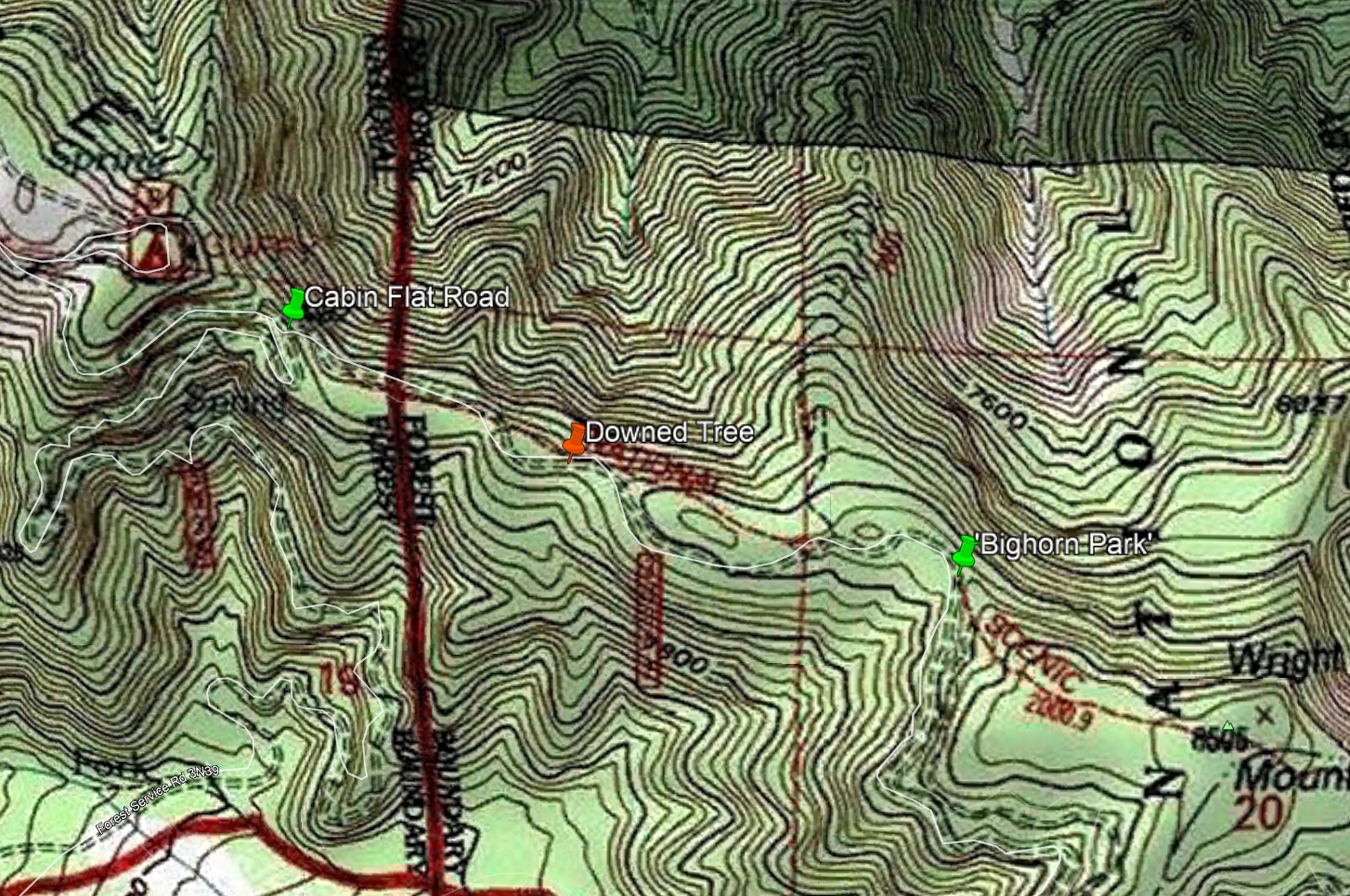
If continuing to Wright Mtn, there is a large downed tree blocking the road about halfway between the road split and 'bighorn park' (the west ridge of Wright). It's possible to drive around the tree, but the easiest bypass puts you on the PCT for about 20m. I was on bike, so no issues.
If continuing to Wright Mtn, there is a large downed tree blocking the road about halfway between the road split and 'bighorn park' (the west ridge of Wright). It's possible to drive around the tree, but the easiest bypass puts you on the PCT for about 20m. I was on bike, so no issues.
-
Slowest_Hiker
- Posts: 282
- Joined: Sun Jul 31, 2011 12:31 pm
Interesting, if I understand the location correctly, the fallen tree on the way to Wright Mtn was not there on the 23rd.
Also: we got to Lupine last weekend! (which is 3N39, but seems to be discussed here since the gate at Guffy is 3N06). I have to agree with the ANF, which says "Road is in poor condition, please use caution". There are 2 issues: the rockfall, which to my memory is a worse situation than when we went there 6 years ago in an arguably inadvisable vehicle. -- not just rocky but some deep dips. And there's what I'm calling a "slump" off the mountain on the way down. We saw this last year on foot and it may or may not have been touched up a little bit (at least, vehicles have scoured off the plants that were growing on top) but it's still there. Recommend high-clearance vehicles with at minimum AWD. Of course that's easy for me to say, now that we have one that meets or exceeds that ?
We saw 2 trucks down at Lupine, one parked before the rockfall, and a group of 4 that started onto the rockfall and turned around and pulled over. Not sure whether they gathered themselves and tried again (we were on our way out).
You do not have the required permissions to view the files attached to this post.
-
Tom Kenney
- Posts: 386
- Joined: Sat Sep 29, 2007 7:51 pm
Looks like the downed tree has been there a while. It's big, about 1.5m dia. Here's the approximate location (only 92% sure, since I was on a night ride):
-
Slowest_Hiker
- Posts: 282
- Joined: Sun Jul 31, 2011 12:31 pm
Huh, I guess maybe it just didn't register since there was a workaround!
-
jfr

- Posts: 154
- Joined: Sat Dec 12, 2009 3:01 pm
Heh - Great thread - goes all the way back to 2008! But it's all about Blue Ridge Road, and that's what matters.
Anyway, I was thinking of hiking a section of PCT along Blue Ridge over Memorial Day, and wanted to head up there early, on say May 18th or 19th, in order to drop off a cache of water with my son using his 4WD truck.
Does anyone know if the road is open for the Summer yet? And how far you can get toward Wright Mountain?
My hiking trip reports: https://hikingtales.com/