Hi, Rob. Do you have any pics of Oakwilde from the '70s or '80s?robow8 wrote: My name is Rob, and I'm an old fart (59). Started backpacking in Scouts in the 70s, as a Scout leader took boys out in the 80s. Hoegees, Oakwilde, Gabrielino trail; we went all over the place. Life got in the way until a few years ago when me and my wife started backpacking again. We love getting out, and spend a week every year up in the Sierra.
INTROS - New members, introduce yourself here!
-
Sean

- Cucamonga
- Posts: 4283
- Joined: Wed Jul 27, 2011 12:32 pm
-
Jesse
- Posts: 3
- Joined: Sun Oct 07, 2018 4:19 pm
Hey guys, I've been lurking this forum for awhile and love the trip reports and info. I actually have some mutual friends with members on here. I'm always looking for more adventurous friends and new places to explore. Glad to be a part of this community.
-
Jesse

- Posts: 3
- Joined: Sun Oct 07, 2018 4:19 pm
-
ReFreshing

- Posts: 68
- Joined: Mon Nov 26, 2018 1:00 pm
Realized I never wrote anything here. Got into the socal hiking scene about this time last year. Tried to hike as much as I could and found out I really enjoyed it. Towards the end of last year started to get into some more mountaineering type stuff with ice axe/crampons and it was fantastic. Loved it. I post regularly on the /r/socalhiking subreddit, which is where I learned of this awesome forum. I also enjoy working out at the gym a lot and cycling, which I occasionally do. I get very inspired by people TRs especially when they are about very challenging adventures. It makes me want to get out on the trail and log miles. But I still consider myself a beginner when it comes to hiking so I love reading the web about socal hikes and learning about all the possibilities out there.
-
Sean

- Cucamonga
- Posts: 4283
- Joined: Wed Jul 27, 2011 12:32 pm
Welcome! I look forward to reading about your future adventures. Some of the best trips I've done were on Baldy in winter.ReFreshing wrote: Towards the end of last year started to get into some more mountaineering type stuff with ice axe/crampons and it was fantastic. Loved it.
-
robow8
- Posts: 43
- Joined: Wed Oct 12, 2016 4:14 pm
Sean, just saw this today; sorry! Unfortunately I don't have any photos of Oakwilde or of any of our other ramblings.Sean wrote:Hi, Rob. Do you have any pics of Oakwilde from the '70s or '80s?robow8 wrote: My name is Rob, and I'm an old fart (59). Started backpacking in Scouts in the 70s, as a Scout leader took boys out in the 80s. Hoegees, Oakwilde, Gabrielino trail; we went all over the place. Life got in the way until a few years ago when me and my wife started backpacking again. We love getting out, and spend a week every year up in the Sierra.
-
ReFreshing

- Posts: 68
- Joined: Mon Nov 26, 2018 1:00 pm
Thanks! I went up the Baldy Bowl twice and I absolutely loved it.Sean wrote:Welcome! I look forward to reading about your future adventures. Some of the best trips I've done were on Baldy in winter.ReFreshing wrote: Towards the end of last year started to get into some more mountaineering type stuff with ice axe/crampons and it was fantastic. Loved it.
-
margaritox
- Posts: 19
- Joined: Thu Nov 12, 2020 9:47 pm
Hi! I’m new here
I like exploring interesting places and finding abandoned mines!
Lots of interesting information on these forums
I like exploring interesting places and finding abandoned mines!
Lots of interesting information on these forums
-
Sean

- Cucamonga
- Posts: 4283
- Joined: Wed Jul 27, 2011 12:32 pm
Welcome to the forum! We have a few mine hunters here. Please share your adventures in the trip report sections.margaritox wrote: Hi! I’m new here
I like exploring interesting places and finding abandoned mines!
Lots of interesting information on these forums
-
David Martin
- Posts: 86
- Joined: Sun Nov 08, 2020 7:08 pm
Hi, new member here, and thought I'd introduce myself.
I learned of this forum through Dima, who I’d known through a local cycling group for many years. On weekly rides Dima often answered my “What have you been lately” question with a humble recap of some local adventure, often in the San Gabriels, almost always involving some peak or trail I’d never heard of.
After the group disbanded about a year ago I began hiking more; usually with a friend and sometimes with my wife. Over the summer we did the Backbone Trail (for the second time) in once a week segments, from west to east. Despite the heat and smoke it was hugely satisfying to get away, and nearing Will Rogers Park we didn’t want it to end. So I mapped an extension that continued over the peaks and ridges to downtown L.A. and we finished at good old Phillipe’s about 6 weeks ago. After that we needed a new hiking “project" but where? Well, it had to be the San Gabriel range, and I started thinking that we should just do some big circuit of it -- fire closures, trailhead limitations, and weather notwithstanding. We started from my friend’s house in Glendale and are now doing segments near Magic Mountain and Vasquez Rocks. Soon it’ll be time to swing east, around the back side of the range. I barely know that area, which makes it better. Dima’s given me loads of information and I’ve spend many hours reading posts here (especially David R’s), which have been very helpful.
I started hiking when young. My grandfather was an outdoorsman and naturalist who worked for the L.A. County Museum and my parents were avid hikers, so I grew up spending a lot of time outdoors. In the early 80’s I became interested in Asia travel, and that became a lifelong passion. I’ve probably made 35 trips there, and my wife and I have a place in northern Thailand now. (Hopefully we'll go back there one of these days, when life starts returning to normal!)
On the first Asia trip I did some trekking in India and Nepal and fell in love with that, leading to many more trips there. I learned some Nepalese, and did most of the well known Himalayan treks. The 80’s and 90’s were a golden time for Nepalese trekking. Most of the villages were still traditional with little development; the locals were kind, helpful and welcoming. I was a hero once or twice, a knucklehead much more often, and overall, pretty lucky. There were plenty of adventures and unusual experiences up there.
Most of my time has been in Southeast Asia; not the subcontinent. Travel there has mostly been by road, train, boat, or bike but I’ve done some treks and long walks in China, Laos, Burma, and Thailand. Some of those excursions were to very odd, remote places. Probably my favorite was traveling the Burma Road from Kunming to Lashio, which took 10 years to realize. Another highlight was hiring a series of local boats down the Mekong River from the China/Lao border to Phnom Penh. (I still want to go the rest of the way, to Saigon.)
For now that exotic stuff is on hold, but hiking and learning the San Gabriels is providing plenty of adventure and new experiences, and the number of destinations seems almost unlimited. I’m approaching these hikes as a “trek” — a combination of trails, fire roads, and bushwhacking, done in segments with a shuttle vehicle. It’s been going great.
So far I don't have much local intel to contribute, but will check in from time to time and will probably have some questions as my SG circuit progresses. Thanks again!
-
Sean

- Cucamonga
- Posts: 4283
- Joined: Wed Jul 27, 2011 12:32 pm
Wow! And welcome to the forum! A little less ambitious would be the Burma Road at Chantry Flat. That's about my speed these days. But I guess that area is still closed from the Bobcat Fire.David Martin wrote: Probably my favorite was traveling the Burma Road from Kunming to Lashio, which took 10 years to realize.
-
David Martin

- Posts: 86
- Joined: Sun Nov 08, 2020 7:08 pm
Hi Sean. Actually I walked part of our local Burma Road a few weeks ago as part of a loop around The Pinnacle on a recent San Gabriels hike. The name gave me a laugh and I guess there's a slight resemblance. The real Burma Road passes through part of the lower Himalayas, going across the grain of the land and crossing several major rivers including the upper waters of the Mekong. There are many dramatic elevation changes, and countless switchbacks.
From a great old book by a Chinese engineer about the Burma Road (which actually continues to Lashio on the Burma side):
From a great old book by a Chinese engineer about the Burma Road (which actually continues to Lashio on the Burma side):
You do not have the required permissions to view the files attached to this post.
-
walker
- Posts: 248
- Joined: Mon Apr 08, 2013 11:14 pm
Welcome, David. Those sound like some unforgettable adventures. I also like the idea of looking for adventure close to home - did you manage to include some of the old staircases on your way through silverlake and echo park? Natural history and urban archaeology.
I had forgotten that the San Gabriels can boast of two Burma Roads, though neither matches the scale of their namesake!
Hope to see you on the trail.
Happy new year!
I had forgotten that the San Gabriels can boast of two Burma Roads, though neither matches the scale of their namesake!
Hope to see you on the trail.
Happy new year!
-
courtney
- Posts: 37
- Joined: Tue Jun 27, 2023 11:01 pm
I have been commenting a bit around here, so I suppose I should introduce myself! I’m a music nerd and musician and have been in bands since I was a teen in the ‘90s. Despite growing up not too far away in the SFV, I’d never spent any time in the San Gabriels until I moved to the area five years ago. I started exploring on foot and quickly found myself enamored with the mountains. I had done a bit of hiking elsewhere, as I’ve always been a lover of the outdoors, but having this vastness so immediately available kicked my casual enjoyment into overdrive.
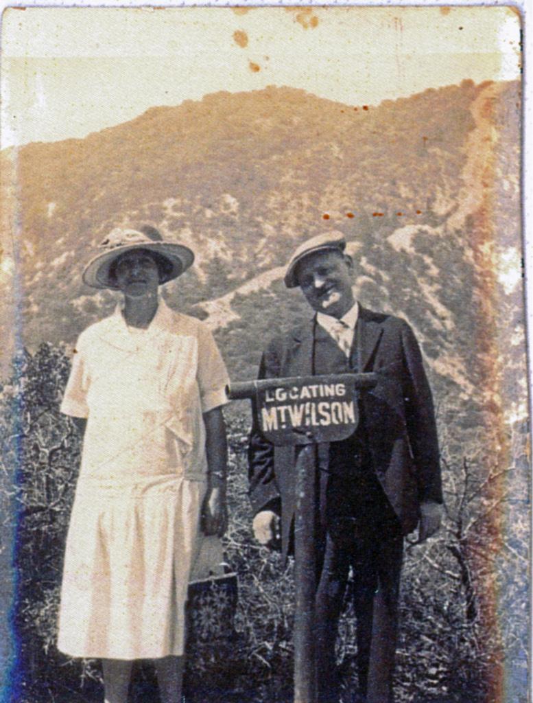
I have spent many hours studying maps and reading whatever I can find. It was the Mt Lowe Railway which I first became obsessed with, and that has shown itself to be but a gateway to all the other amazing history in these mountains. Incredibly, after seeing a photo of me on Echo Mountain, my uncle (who used to build/fix radio towers on Mt Wilson) sent me a photo of my Great, Great Grandparents on the summit of Mt Lowe! They had moved to LA from Rotterdam, and in the early 1900s were able to ride the railway. I had no idea until seeing the photo, but do wonder if somehow my DNA knew, and pulled my focus to the area.
I’ve had some health issues which have held me back from doing as much exploring as I’ve wanted, but I hike as much as I can. I also do trail work with Sean (am still learning!), and so far have been on one group hike to Lizzie’s Vista (part one of the Rose Peak hike), which is when I found out about this board.
Compared to all of the numerous experts here I still consider myself a relative newbie, so I am stoked to have found such a wealth of knowledge in you all. I look forward to learning more from you!

-
HikeUp

- Posts: 4063
- Joined: Thu Sep 27, 2007 9:21 pm
Welcome.
I like TRs. I encourage everyone to write up even the smallest hikes.
I like TRs. I encourage everyone to write up even the smallest hikes.
-
Uncle Rico

- Posts: 1484
- Joined: Thu Mar 20, 2008 7:48 pm
Really cool pic of your great, great grandparents. When I see those old pics of folks hiking, I'm always impressed by the fact that the ladies were always in dresses and the gentlemen in coat and tie. I can't even fathom.
Looks like there's a firebreak going up that ridge in the background. Anybody know where that is?
Looks like there's a firebreak going up that ridge in the background. Anybody know where that is?
-
Sean

- Cucamonga
- Posts: 4283
- Joined: Wed Jul 27, 2011 12:32 pm
That's the Lowe firebreak that goes up the SW ridge. They're standing in the vicinity of Inspiration Point with Mt. Lowe in the background.Uncle Rico wrote: Looks like there's a firebreak going up that ridge in the background. Anybody know where that is?
-
courtney

- Posts: 37
- Joined: Tue Jun 27, 2023 11:01 pm
i had wondered about this and almost addressed it in my post. my uncle said it was inspiration point, but i sent it to eric at the historical society a few years ago, and he said, “The ridge lines in back and the direction of the Mt. Wilson eye tube both match Mt. Lowe.” but even after studying the ridgelines i have never been positive! thanks sean!Sean wrote:That's the Lowe firebreak that goes up the SW ridge. They're standing in the vicinity of Inspiration Point with Mt. Lowe in the background.Uncle Rico wrote: Looks like there's a firebreak going up that ridge in the background. Anybody know where that is?
-
Sean

- Cucamonga
- Posts: 4283
- Joined: Wed Jul 27, 2011 12:32 pm
Yeah, the tube direction fits either Lowe summit or Inspiration Point, but the background only fits Inspiration Point. I could provide reference photos, but I recommend hiking up there and trying to match the exact spot yourself. It's fun to look for the ridgelines and rock faces and stuff.
-
Sean

- Cucamonga
- Posts: 4283
- Joined: Wed Jul 27, 2011 12:32 pm
Also, there is an interesting object behind the woman in the photo. It appears to be a wooden trough, perhaps--maybe for the mule that used to push a trolley car along that road. @Paul Ayers might know what it is.
-
courtney

- Posts: 37
- Joined: Tue Jun 27, 2023 11:01 pm
i actually have done, with this photo at the ready, but it was a few years ago! i got confused at the time because all the (current) tubes i saw were pointing toward the city. but since you said “in the vicinity of” i surely just need to do a bit more poking around. i love a good treasure hunt.Sean wrote:Yeah, the tube direction fits either Lowe summit or Inspiration Point, but the background only fits Inspiration Point. I could provide reference photos, but I recommend hiking up there and trying to match the exact spot yourself. It's fun to look for the ridgelines and rock faces and stuff.
-
Nate U

- Posts: 599
- Joined: Wed Apr 05, 2023 7:38 pm
Welcome, Courtney! Sounds like you fit right in here. Looking forward to your TRs and seeing you out on the trail again for more vista points....courtney wrote: I have been commenting a bit around here, so I suppose I should introduce myself! I’m a music nerd and musician and have been in bands since I was a teen in the ‘90s. Despite growing up not too far away in the SFV, I’d never spent any time in the San Gabriels until I moved to the area five years ago. I started exploring on foot and quickly found myself enamored with the mountains. I had done a bit of hiking elsewhere, as I’ve always been a lover of the outdoors, but having this vastness so immediately available kicked my casual enjoyment into overdrive.
-
Sean

- Cucamonga
- Posts: 4283
- Joined: Wed Jul 27, 2011 12:32 pm
That particular tube might not exist anymore. I don't recall seeing it.courtney wrote: i actually have done, with this photo at the ready, but it was a few years ago! i got confused at the time because all the (current) tubes i saw were pointing toward the city. but since you said “in the vicinity of” i surely just need to do a bit more poking around. i love a good treasure hunt.
-
HikeUp

- Posts: 4063
- Joined: Thu Sep 27, 2007 9:21 pm
Me neither.Sean wrote:That particular tube might not exist anymore. I don't recall seeing it.courtney wrote: i actually have done, with this photo at the ready, but it was a few years ago! i got confused at the time because all the (current) tubes i saw were pointing toward the city. but since you said “in the vicinity of” i surely just need to do a bit more poking around. i love a good treasure hunt.
