Misc. News (Archive)

Rescues, fires, weather, roads, trails, water, etc.
Post Reply
User avatar
AW~
Posts: 2040
Joined: Mon Oct 01, 2007 12:00 pm

Post by AW~ »

sad story above....no updates yet....
San Gabriel Mountains
Plateau of mountains
Mirror image made of clouds
Hazy in between
http://advancedpoetry.blogspot.com/2009 ... ns_12.html

WILLIAMSON ROCK UPDATE(meeting w/ affected parties)
http://www.rockclimbing.com/cgi-bin/for ... st=2100960

Add pics of other current conditions:
Fish canyon: http://chuys.blogspot.com/2009/03/more- ... falls.html
Chantry/Newcomb: http://www.socaltrailriders.org/forum/t ... -more.html

Search Crews Find 3 Missing Women Hikers
http://cbs2.com/local/3.waitresses.miss ... 59255.html
"Search and Rescue teams found three women who were reported missing while hiking in Will Rogers State Historic Park(Santa Monica Mountains"

The above one was also mentioned in a blog questioning how someone could get lost on that trail...perhaps as in the question of whether or not some rescues should be billed.....flashback to New Hampshire..."Hikers Could Lose Licenses If They Don't Pay"
http://www.wmur.com/news/18401773/detail.html

SCV Search & Rescue Team Trail Challenge(Santa Clarita Search & Rescue) March 15 through May 31, 2009
http://www.scvrescue.com/events.php

microsite: Glendora Mountain road
http://glendoramtnroad.blogspot.com/
I think excellent coverage of the road and its motorcycles.
Recent picture from the road:
http://4.bp.blogspot.com/_w8aLu9gRwAc/S ... 090314.jpg
User avatar
AW~
Posts: 2040
Joined: Mon Oct 01, 2007 12:00 pm

Post by AW~ »

update the thread to sneak in this offtopic picture of a clouded leopard

Image
http://www.washingtonpost.com/wp-dyn/co ... 9032504014

other wildlife:
Mountain lion making commute toward Malibu(no pictures)
http://latimesblogs.latimes.com/lanow/2 ... rst-t.html
"For the first time since they have been tracking the lion population in the Santa Monica Mountains, the National Parks Service has detected a tagged mountain lion crossing Highway 101 from the Simi Hills south to the hills above Malibu"
The lions of Los Angeles
http://www.dailynews.com/news/ci_11963981
"He was king of the Santa Monica Mountains, the baddest cat around Malibu....But the 11-year-old mountain lion known to ecologists as P-1 — as in puma one — may have met his end this week in a treetop scrap with a smaller, younger cat"
Bear hanging around Monrovia canyon(no pictures)
http://welcometothemeadows.blogspot.com ... adows.html
flashback 1/22/09: http://beaconmedianews.com/2009/01/22/b ... -monrovia/
"The California brown bear managed to elude authorities after he had a good snack of Persimmons from one of Medley’s trees and made for a neighbor’s yard"

wildlife news sourced from http://www.watercacheproject.org/About.htm
something about putting water supplies into our mountains for firefighting/wildlife

The New California Gold Rush
http://www.nbcphiladelphia.com/news/us_ ... -RUSH.html
"Gold also is found in Southern California along riverbanks in the San Gabriel Mountains. One hot spot is a canyon above Azusa, where the road is often lined with campers"...earlier in the article.."John Gurney, who came out to California from the East Coast to find gold, was able to pull out about $35,000 worth of gold nuggets over a couple of months."

Making a Pacific Crest Trail Thru-Hike Itinerary
http://backpacking-trips.suite101.com/a ... _itinerary
"....The Annual Day Zero Pacific Crest Trail Kick Off (ADZPCTKO) is a good guide for when to start. This event takes place at Lake Moreno State Park, 20 trail miles from the Mexican border, in late April (usually the last weekend).
"

No update on offduty police officer in GMR crash since 3/16/09...
http://www.whittierdailynews.com/news/ci_11925816
No real updates on Stark(rock climber) or Collins(suspected murders)
http://columbian.com/article/20090324/NEWS02/703249998/
User avatar
cougarmagic
Posts: 1409
Joined: Wed May 07, 2008 5:21 pm

Post by cougarmagic »

cute kitten.... Interesting about the Millard bear. I thought they should be up & about with the warmer weather. Probably got a real bad case of the munchies.
User avatar
AW~
Posts: 2040
Joined: Mon Oct 01, 2007 12:00 pm

Post by AW~ »

Angeles Crest highway.....

1) 2 dead, 12 hurt when big rig loses control in La Canada Flintridge
http://www.latimes.com/news/local/la-me ... ?track=rss

http://www.kchristieh.com/blog/?p=1269

The driver of the rig(carrying cars???!) was arrested. No statement from Caltrans that I could find.

2)U.S. Forestry Service Law Enforcement on Angeles Crest
http://motocali.blogspot.com/2009/04/us ... nt-on.html
"FYI - The 2 FWY, a.k.a. Angeles Crest Highway, which is a part of the National Park System, now has Law Enforcement Rangers. We saw at least 4 different SUVs all staked out pulling people over. I guess they realized they were missing out on a lot of revenue that CHP was getting. Anyway, slow down on the crest. They will get you"

3)picture: Finished Bridge on SR2
User avatar
cougarmagic
Posts: 1409
Joined: Wed May 07, 2008 5:21 pm

Post by cougarmagic »

AW wrote: 2)U.S. Forestry Service Law Enforcement on Angeles Crest
"I guess they realized they were missing out on a lot of revenue that CHP was getting. Anyway, slow down on the crest. They will get you
More like they got tired of scraping bikes off the road all day every weekend.

A few years ago, a biker passed my car on a blind curve. Came around the corner to see he had wiped out, and stopped to help. I sent a friend down to the ranger station to get someone, when the ranger came up he just looked frustrated. He said "well, I hope you don't mind waiting, because there are two other accidents we're taking care of before you".
User avatar
outwhere
Posts: 323
Joined: Sun Jan 25, 2009 5:40 pm

Post by outwhere »

I'm sorry but I just have about zero pity for those motorcycle guys that think, and use, the ACH as their personal race track...

We've had too many close calls with them.

Ya, we thank you for almost slamming into our car head on just because you want to go extra fast around corners - on a PUBLIC HIGHWAY!

It's one of the most selfish acts there can be...

Running a close second are those jerks on mountain bikes that fly down narrow hiking trails, not even considering all the people they may run into...

I hate even talking about squashing personal freedoms but it comes at the expense, or hurts innocent people, then alls I can say is..... TAKE A HIKE!
User avatar
AW~
Posts: 2040
Joined: Mon Oct 01, 2007 12:00 pm

Post by AW~ »

Yeah, I agree with both of you. I was just happy to see any law enforcement being mentioned as travelling the roads...had one CHP SUV behind me a few months back....no problemo...try and get me for something as long as I get even the minimal benefit of maybe these guys catch or deter someone breaking into cars, etc.

Those motorcycles fill up the incident reports big time. And like you Cougarmagic one happened very close to me on the upper Big T road, which is more like the Autobahn for motorcycles...but a SUV vs(head-on) motorcyle .....yikes... Air5 came in for a landing not long thereafter...

I do what I can to get em through safely, but they can tell me all day its safe and I know its just not safe with all these yahoo drivers..heck even a car is scary to be in.
User avatar
Ze Hiker
Posts: 1430
Joined: Mon Jul 28, 2008 7:14 pm

Post by Ze Hiker »

the first article of news: what a fucking debacle. do people need to have a freaking protest just to get caltrans to prohibit trucks from using those roads?

but hey, the ACH is opening up! can't wait to have more trucks roaring down.

as for motorcycles, whatever. the real problem is when someone's reckless driving affects others. there's enough asses up there crossing the yellow lines around blind curves, just asking for a head on collision. ticket them. get them out of there.
User avatar
Taco
Snownado survivor
Posts: 6010
Joined: Thu Sep 27, 2007 4:35 pm

Post by Taco »

Don't double-lane an open road.

I've been one of those asses before, in theory, but you just gotta go safe. One can still go fast and enjoy the road, just gotta modify your line so that you're not endangering anyone else. A track line and mountain road lines are different because of this.

I've driven up there a ton, and have seen enough crashes and situations like that. I've seen more mature motorcyclists, to be honest. Some of the younger kids, like high schoolers who's parents bought them a new Evo X or something, are a bit more of a problem than those of us who drive up there on a regular basis.
User avatar
Rumpled
Posts: 271
Joined: Mon Feb 25, 2008 10:57 pm

Post by Rumpled »

AW wrote:Angeles Crest highway.....


"FYI - The 2 FWY, a.k.a. Angeles Crest Highway, which is a part of the National Park System, now has Law Enforcement Rangers.
Since when has ACH been part of the National Park System?
User avatar
bertfivesix
Posts: 206
Joined: Wed Dec 19, 2007 3:29 pm

Post by bertfivesix »

Unofficial report is out on the accident we witnessed at JTree last month.
"1. Woody Stark led a 100' climb on The Great Burrito formation (Real Hidden Valley). He placed an anchor on top.

"2. Al Kwok followed the climb, trailing a second rope for the third person (Wendell Smith). The second rope was attached to the back of his harness.

"3. 65' (approx.) of slack in the second rope was pulled up, to prepare for belaying Smith, and a knot was tied in the second rope at this point (65/100). This knot was clipped to the anchor by Stark. Smith was tied into the second rope at this time.

"4. Before Smith started climbing, Stark requested that Kwok lower him to the ground. At this point, Kwok probably believed that the second rope anchored him closely to the belay anchor, but there was in reality 65' of slack in between.

"5. Kwok began lowering Stark. [Edit:] After Kwok had lowered Stark about 35', Kwok probably shifted his weight forward, expecting to be held by the second rope. Due to the slack in the second rope, Kwok kept moving forward and fell along with Stark.

"6. Kwok fell 65' (approx.) and was held by the second rope at this point (the haul loop on the back of his harness was strong enough). [Edit:] During the 65' fall, Kwok did not lose control of the lowering device. Stark fell 100' total to the ground, receiving a fatal head injury.

"7. Smith untied Stark from the lead line, to relieve pressure on Kwok."
Complacency kills. Check yourself, check your partner, check again. Stay safe, everyone.
User avatar
AW~
Posts: 2040
Joined: Mon Oct 01, 2007 12:00 pm

Post by AW~ »

Thanks for the update....

Fatal big-rig crash sparks truck ban
http://abclocal.go.com/kabc/story?secti ... le-6744187
"The California Highway Patrol has been informed to have extra enforcement out on Angeles Crest Highway during the 90-day truck ban. ..."

New gold rush hits California(new item)
http://www.rgj.com/article/20090403/NEW ... /1321/NEWS
".....There are better places to go,” says Martin Milas, a Los Angeles lawyer and president of the Prospectors Club of Southern California. “It’s been known for over 150 years. It’s just that, you can always get some color (gold) there.”
DeMello, 60, and his prospecting partner, Mike Gavin, 53, a Los Alamitos roofer idled by the business slowdown, drove 20 miles into the forest north of Azusa, Calif., then hiked up a trail into East Fork Canyon and hopped rocks jutting out of the side of the fast-rushing river, passing trout fishermen, until they found a spot that looked promising. Gavin shoveled furiously along the bank while DeMello sifted and sorted through the dirt.
Reducing his shovel contents to mostly sand, he deposited it slowly into a metal sluicer, a piece of equipment refined but little changed in a century and a half. Placed so that river water runs through it, the sluicer catches the heaviest particles in its carpet-like bottom - and the heaviest material is gold.
They didn’t find enough to buy dinner but did get small pieces for their collections.
Downstream, Marc Montelius, 50, of Whittier, was panning and sifting while three friends dug and offered advice from the riverbank. He is a self-employed handyman waiting for an oil refinery job.
”I have no illusions of grandeur, that I’m going to strike it rich,” he said. “It’s a good excuse to get out of the house.”

Rialto Historical Society to host authors of mountain book-was April 1st
http://www.sbsun.com/ci_12047830?source=rss
"Ann and Farley Olander will discuss their {2005} coffee-table book "Call of the Mountains: The Beauty and Legacy of Southern California's San Jacinto, San Bernardino and San Gabriel Mountains." "
Blog: http://callofthemountains.wordpress.com/posts/

Another book: Crazy for the storm
http://www.thenovelbookworm.com/2009/04 ... -2009.html
"Flying to a ski championship ceremony in February 1979, the chartered Cessna carrying Norman, his father, his father's girlfriend, and the pilot crashed into the San Gabriel Mountains and was suspended at 8,200 feet, engulfed in a blizzard. "Dad and I were a team, and he was Superman," Ollestad writes. But now Norman's father was dead, and the devastated eleven-year-old had to descend the treacherous, icy mountain alone. "

Incidents:
04/04/2009 16:50 4 Loose Pigs - Little Tujunga Cyn. Rd. near mm 10.81

:-) actually still the same..vandalism, illegal parking at maxed out places, a few S&Rs(Baldy,Eaton Falls,Mtn High (which appararently is still pushing out snow)etc)
User avatar
AW~
Posts: 2040
Joined: Mon Oct 01, 2007 12:00 pm

Post by AW~ »

Los Angeles County Car Accident Injures Two
http://www.trafficaccidentnewsandadvice ... ident.html
"A man and a woman suffered injuries in a Santa Clarita car crash the morning of April 14, 2009 after their Porsche veered off the side of Little Tujunga Canyon Road in the Angeles National Forest and plunged at least 500 feet down into a canyon......If this accident was caused by a dangerous or defective roadway, the governmental agency in charge of maintaining it could be held liable. In such cases, claims against California governmental agencies must be filed within six months of the accident..."

Update on the big rig/angeles crest accident
http://blogs.laweekly.com/ladaily/city- ... -rig-driv/
"The Pasadena Star-News reported that Adonai & Associates of Kennesaw, Georgia, while not having suffered any previous crashes, has had its drivers removed from their rigs 33.3 percent of the time following safety inspections..."

Future of Antelope Valley’s Lake Elizabeth rests with buyer
http://aquafornia.com/archives/7965
"And now, many worry about its future, after its owner recently put much of the lake and its surrounding acreage up for sale at $19.5 million.

The owner, Ridgetop Ranch Properties Inc., would prefer to see the property preserved in its pristine state, said Jeff Johnson, the chief financial officer. But at the same time, the Big Sky, Mont.-based company won’t necessarily oppose development such as a fishing club or cabins — a prospect that worries environmentalists and local townsfolk"

Everything Old is New Again(direct link didnt work out)
http://www.paleoclub.com/blog/
"Pictured above is the Pole Canyon Fault, located off Highway 14 in Sand Canyon in California’s San Gabriel Mountains. The light rock unit is the Mint Canyon formation, Miocene in age. Below the fault is a rock called Norite, an Orthopyroxene rich rock associated with Anorthosite. However the Anorthosites found near here are older than 100 million years, much older. This Anorthosite complex is around 1.2 billion (that’s billion with a ‘b’) years old..."

Trs & photos:

http://palosverdesdailyphoto.blogspot.c ... om-ca.html

Kagel(also includes multiple SG mtn locations)
http://socalxc.blogspot.com/2009/03/kagel.html
"Distance: 61.09 Miles Duration: 3:28 Hours"

Red Box - Bear Canyon Loop:20 miles
http://www.photographyontherun.com/RedB ... nLoop.aspx
Red Box-->, West Fork SG river via Gabrielino Trail --> Valley Forge via Gabrielino Trail-->Eaton Saddle via Valley Forge-->Mt Lowe via Mueller Tunnel & Mt Lowe fire road-->Bear Canyon via MtLowe west ridge and Tom Sloan saddle dropin-->Switzers-->Redbox
User avatar
AW~
Posts: 2040
Joined: Mon Oct 01, 2007 12:00 pm

Post by AW~ »

New study on mountain lion attacks raises eyebrows
http://www.rgj.com/article/20090419/NEW ... /1321/NEWS
also article in Scientific American...
"Staying put may make a person more desirable as potential prey and prompt an attack, said researchers at University of California, Davis"

More mountain lion conversation...
http://www.scpr.org/news/stories/2009/0 ... ml?refid=0

Auction of 308-acre habitat Wednesday is upshot of habitat lawsuit
http://www.pe.com/localnews/inland/stor ... 2d0f3.html
"308-acre preserve in the scenic Etiwanda Canyon sold at auction Wednesday morning on the steps of the county courthouse in San Bernardino.
The minimum bid will be $0.00, according to an official notice of the sale"

Felix Mine(never said exactly where this is)
http://www.mindat.org/article.php/341/F ... not+minium
"The Felix Mine located near Azusa, Los Angeles Co. CA has been known as a source of fine fluorite specimens at least since January, 1892 ...The mine is located along the base of the San Gabriel Mountains about a mile east of the San Gabriel River near the town of Azusa. It is on a steep, brushy hillside composed of decomposing granite"

New wilderness being figured out...appears Burkhardt trail will not be allowed for mountain bikers...
http://www.socaltrailriders.org/forum/t ... -gabs.html

Conditions:
Trail canyon: http://fieldofdandelions.blogspot.com/2 ... lucas.html
Switzer Falls: http://rgsphotos.blogspot.com/2009/04/s ... orest.html

Rescuers search forest above Altadena for missing bicyclist
http://www.sgvtribune.com/news/ci_12167103?source=rss
"The family members who reported the 41-year-old South Pasadena man missing simply did not see him come home, change clothes and leave for a friend's house where he spent the night, Los Angeles County sheriff's Lt. Greg Sisneros said"

http://www.urbanmushing.com/main.htm
Image
"Pack up your furry friends and come to Harmony Pines Christian Camp for a weekend of mountain mushing fun from May 1st to May 3rd! Harmony Pines is located 6,000' up in the Angeles National Forest near Wrightwood, CA."
User avatar
AW~
Posts: 2040
Joined: Mon Oct 01, 2007 12:00 pm

Post by AW~ »

Man rescued after days trapped in forest
http://www.whittierdailynews.com/news/c ... source=rss
"He was found on the Bear Canyon Trail, about 15 miles north of La Canada Flintridge, Caffrey said...."

Speaking of Bear Canyon(one picture incl)
http://www.kchristieh.com/blog/?p=1286
"It shouldn’t surprise anyone that my friend Jane G. spotted a bear as she hiked through Bear Canyon in Angeles National Forest the other day..."

Man struck by shrapnel at shooting range(Burro Canyon)
http://www.whittierdailynews.com/news/c ... source=rss
"The man, estimated to be in his 20s, suffered an apparently minor wound, however he was flown to Los Angeles County-USC Medical Center by helicopter as a precaution, the captain said. "

American Forests Announces 2009 Global ReLeaf Projects
http://yubanet.com/enviro/American-Fore ... ojects.php
"California: For the Curve – Hwy 2 Project, American Forests will give funding to the Angeles National Forest to plant 6,000 trees to restore an area devastated by the Curve Fire.
California: At the Charlton-Chilao Project, 4,000 seedlings will be planted in a recreation site in the Angeles National Forest to ensure the continuation of old growth forest.
California: For the Charlton KV Project 3,000 seedlings will be planted in the Angeles National Forest to restore the watershed and old growth forest, and to improve wildlife habitat."

Historical: Songs About Los Angeles: "The New Year’s Flood" by Woody Guthrie(Montrose flood incl 2 pictures)
http://la.metblogs.com/2009/04/23/songs ... y-guthrie/

“In 1934 on New Year’s night was one of the worst that ever hit at anywhere and anytime and it killed over one hundred people – and that many was reported; I guess there was a hundred more than there was reported.”

Asuza OHV
http://www.ripetv.com/videos/view/2277/
Not all the video in Asuza of course....

Conditions:

Third Stream(Middle Fork Lytle Creek)-
http://troop899.blogspot.com/2009/04/ly ... -hike.html
http://duffyknox.smugmug.com/gallery/80 ... mbR#P-1-20

source: duffyknox.smugmug.com
Image

Lower Devils Canyon,Cooper Canyon Falls, Hermit Falls, Millard Canyon Falls,Sturtevant Falls,Long Canyon Falls,Royal Gorge
http://www.flickr.com/photos/zeroy/page2/
User avatar
AW~
Posts: 2040
Joined: Mon Oct 01, 2007 12:00 pm

Post by AW~ »

addntl deaths, etc

Missing boy found dead, parents suspect of murder
http://www.mydesert.com/article/2009051 ... 035/-1/rss
"He said the body was recovered in the Lytle Creek area just south of Wrightwood."

Rancho Cucamonga man dies while on mountain motorcycle ride
http://www.sportbikers.net/forums/showt ... hp?t=18164
"Carver, 49,who was riding a white-and-blue Suzuki dirt bike, planned to take the trail from Lytle Creek to the Joe Elliot Campground"

05/07/2009 Animal abandoned near Bear Divide Miscellaneous Little T Canyon Rd MM 13.11

Abandoned animals:
http://teh-kitteh-antidote-anecdote.pic ... round.html

Angeles Crest again:
Big rig overturns on Angeles Forest Highway
http://www.noosoop.com/2009/05/11/big-r ... t-highway/
"The truck was hauling a load of gravel when it lost control, hit the mountainside and then flipped onto its side, Williams said. Most big rig trucks on the highway are subject to a 90-day ban that was established April 5 by Caltrans and prohibits them from using Angeles Forest and Angeles Crest highways"

Bears(300lbs wooo):
http://www.modernhiker.com/2009/05/06/year-of-the-bear/

Also:
05/10/2009 Rattlesnake Bite Medical Aid ACH/Camp Eaton mm 52.85

Conditions:
Hike 3 - Burkhart Trail to Cooper Canyon Falls
http://www.100hikes.com/blog/?p=94

http://www.socaltrailriders.org/forum/t ... trail.html
"Took a chance to see if the Forrest Service has put up the Wilderness "no bikes" signs and as of today they are not up. I am not sure when the new Wilderness designation takes effect but I strongly suggest that you get your Burkhart fix in before the signs are up"

97/300: Strawberry Peak
http://poorslobwithoutaname.wordpress.c ... erry-peak/
"While we were still at the summit a group of 4 hikers came up from the other side of the mountain and stopped at the summit as well. One man told this really interesting story about a group of people who were at a fair in Santa Anita back in the early 1900s. They took a tethered hot air balloon ride. However, a big storm blew in unexpectedly and the rope holding them to the ground broke. They drifted through the clouds not having any idea where they might be headed. Both spectators on the ground and the passengers of the balloon thought the end was near for them. The rode out the storm and when the clouds broke, landed on the first bare patch of land they could find, which was the top of Strawberry Peak. Apparently this happened in February and the snow was several feet deep on the top of the mountain. Eventually after wandering around for a day or two, someone found them and helped them down the mountain to Switzer’s which is now a popular picnic and hiking spot. There was telegraph at Switzer’s so the news of their rescue spread all over the world. "

have to list our own's Ze again for BigHorn ridge just because
http://socalhikes.com/

another site along much the same topic:
http://socalpeakbagger.blogspot.com/

misc:
Glendora mountain ridge road(San Dimas Stage Race)&very general info
http://glendoramtnroad.blogspot.com/200 ... -road.html

plenty of others relating to the PCT, training for bike and running races
"Going to new heights"
http://www.clintdavis.net/blog/?p=110
[few pictures of hwy 39 above the closure]

Vivian Creek(canyoneering)
http://canyonaddict.blogspot.com/2009/0 ... s-wet.html
User avatar
AW~
Posts: 2040
Joined: Mon Oct 01, 2007 12:00 pm

Post by AW~ »

Image
http://transsylvaniaphoenix.blogspot.co ... -adog.html

New bridge on Highway 2, slides still threaten road
http://watershednews.blogspot.com/2009/ ... crest.html
"The new bridge is slickly designed, to allow future slides to pass under the roadway. But it's only 208 feet long, according to Caltrans, so most of the road remains vulnerable to erosion"

monrovia canyon to chantry flats(bike ride)
http://www.socaltrailriders.org/forum/t ... flats.html
"this was my second attempt at a ride that ended in a helicopter ride off the mountain last year. the plan was to go up monrovia canyon, climb up 2n30 (white saddle road?), cut across via 2n24 to newcomb pass, and drop into chanty flats"

Noted that thread included yet another mapping website...
http://trail.motionbased.com/trail/netw ... st/view.mb

disgraced Monkey Canyon
http://losangelesswimmin.com/?p=82
"There were many broken bottles, tons of graffiti but otherwise very little trash compared to the diaper and dead dog days of 2007"...hehehe for some reason I dont think people will have to wait long for more trash.

Bridge Bungee America jumping
User avatar
AW~
Posts: 2040
Joined: Mon Oct 01, 2007 12:00 pm

Post by AW~ »

Fee Repeal and Expanded Access Act of 2009(Toss Adventure pass fee out the window Act)
http://mt-govinfo.blogspot.com/2009/05/ ... ct-of.html

http://www.indybay.org/newsitems/2009/0 ... 598385.php
"The California Senate today approved a bill banning suction dredge gold mining on certain California rivers by a vote of 31 to 8"

Staring at the Sun, Just as Galileo Did
http://discovermagazine.com/2009/jun/27 ... alileo-did
"Astronomers at the Mount Wilson Observatory sketch sunspots every day, continuing a tradition started by Galileo"

Historical:Rubel Castle(Glendora)
http://hometown-pasadena.com/2009/05/th ... st-castle/
"The castle’s walls, hand-built of San Gabriel River rock, are studded with every imaginable castoff: a toaster, the rear end of a motorcycle, a telephone, a variety of small sculptures"

Injured man flown out of forest north of Azusa
http://www.sgvtribune.com/news/ci_12444494?source=rss
"The rescue occurred just before 5 p.m. near San Gabriel Canyon and West Fork roads.......The man reported falling four to six feet, while his family members told officials he fell from about 45 feet"

Big Horn mine tr(Note: there is a part 2 and other post about a cabin)
http://the-great-silence.blogspot.com/2 ... art-1.html

http://mickieszoo.blogspot.com/2009/05/ ... anyon.html
"The US Forest Service will have its monthly Naturalist led tour($5) on Saturday, May 30th 2009.....This month we will be exploring the rich and colorful history of the San Gabriel Canyon....Visitors will learn about the Gabrielino/Tongva, our Native Americans who inhabited our local foothills and mountains, the great rancheros of the early 1800,and the colorful and sometimes rowdy gold mining history of Eldoradoville on the East Fork.On one of our stops we will see the location of the Forks Dam fiasco, the San Gabriel Canyon Railroad, and the Navy torpedo test site"

Santa Barbara fire
http://cbs2.com/firewatch/brush.fire.wi ... 04379.html
"Fire officials said someone, or possibly a group of people, was clearing vegetation on what appeared to be private land near the trail around the time the fire erupted Tuesday...Some Santa Barbara County residents recently received annual notices advising them they had until June 1 to clear potentially hazardous brush, county fire Capt. Glenn Fidler said."
"
video of angeles forest firefighting effort..
http://www.truveo.com/helicopter-drops- ... 1062429090#

Chantry Flats
http://www.adamspackstation.com/
"The County has started work on the Sierra Madre section of the Chantry Road. That's the good news. The bad news is that the road will have only one lane open during the week between 8:30 AM and 4:30 PM. The work is expected to last until July 15th. The road will be open on the weekend from 6:00 AM to 8:00 PM."

Also should note they have some pack trips up to Valley Forge($250pp)
User avatar
Taco
Snownado survivor
Posts: 6010
Joined: Thu Sep 27, 2007 4:35 pm

Post by Taco »

"The rescue occurred just before 5 p.m. near San Gabriel Canyon and West Fork roads.......The man reported falling four to six feet, while his family members told officials he fell from about 45 feet"

My medical prowess points to the suggestion that he fell 45ft and hit hard. :lol:
User avatar
AW~
Posts: 2040
Joined: Mon Oct 01, 2007 12:00 pm

Post by AW~ »

Man set ablaze, identity a mystery
http://www.dailynews.com/business/ci_12 ... source=rss
"CASTAIC-Detectives continued to investigate the death of a man whose body was found on fire in the Angeles National Forest near Castaic, a sheriff's deputy said.

A passerby reported a small trash fire near Templin Highway, near the Golden State Freeway on Saturday, according to a deputy"

Angeles Crest items
New road, new concerns
http://www.crescentavalleyonline.com/ar ... andach.txt

"If a trucker ignores the [restriction] signs on the roads the [equipment] will read the license plate and relay that information to law enforcement,” Do said. “If we had a motion sensor or license plate reader [in place before the accident] that could have alerted law enforcement and they may have been able to stop the truck....Najjar(most recent accident) reportedly told CHP officers that his brakes failed and he was unable to slow down. His truck gained speed to about 50 mph as it entered a moderate right-hand curve on the roadway; it was at this point when the truck overturned onto its left side, spilling its entire load onto the pavement.

The highway was closed for about 90 minutes while maintenance crews cleaned the area. Najjar complained of pain but was not transported to a hospital. Najjar was under contract to deliver the gravel to the Upper Big Tujunga reservoir and was exempt from the restriction for commercial vehicles on Angeles National Forest."

For bikers, the Angeles Crest high is like no other
http://www.mercurynews.com/travel/ci_12 ... source=rss
"According to the Statewide Integrated Traffic Records System, 33 motorcyclists have died on Angeles Crest since 1998, many of them on Woodwardia Bridge, just a few miles from the road's start......From 1929, when construction began, to 1956, when the road finally opened, prison labor from San Quentin and the Chino Institution for Men cleared the rocky, pine-covered wilds, blasting away boulders with the 1,000 pounds of dynamite they were given each day and rolling the debris into the 500-foot canyons below.......A sprawling log cabin with an oversized parking lot to accommodate the weekend masses, Newcomb's is located 27 miles — and 198 turns — up the Crest, past corners with names such as Moron's Point — so-called for the switchback where a California Highway Patrol officer is known to lurk — but before Squid's Leap, a surprisingly sharp turn that has jettisoned many an inexperienced rider over the edge"

Schwarzenegger proposes closing 80 percent of California state parks
http://www.mercurynews.com/politics/ci_ ... source=rss

New Water Restrictions Go Into Effect Today
http://www.knx1070.com/New-Water-Restri ... ay/4508898
"One hundred cubic feet equals 748 gallons.....Residential offenders can be fined up to $300 and commercial customers up to $600 for wasting water"

Rattlesnake Avoidance training
http://awinnieday.blogspot.com/2009/05/ ... ining.html
"The trainers recommended coming back to rattlesnake avoidance training again next year - just to be sure that the training has taken "effect". They said that with most dogs, two to three repeat lessons are the most effective. However, they have seen cases where some dogs come back year after year not retaining anything. I doubt Winnie falls in that category. It only took her 3 zaps to learn that snakes are not cool to be around"

Dog who challenged lion named K-9 hero
http://www.ocregister.com/articles/hogg ... tain-morse
"ARCADIA – Hoggie – the dog who tangled with a mountain lion in the Cleveland National Forest earlier this month – was named K-9 Hero of the Year in a parade in Arcadia on Saturday....Hoggie received at least 100 stitches"

other trip reports:
Ice House Canyon(Also blogged :SoCal Hikes captures the raw beauty of Glendora Ridge Road wending its way to Mt. Baldy as viewed from the Big Horn Ridge..filed under 'Glendora Ridge Road')
http://glendoramtnroad.blogspot.com/200 ... anyon.html
Icehouse Canyon to Cucamonga Peak
http://www.ephonium.com/greetingsfromla/?p=1120
"But fortunately, flickr comes to the rescue, and a search yielded some great pics by simonov that are representative of my experience".....

OTB's Epic Chilao 2009(May 4th,2009)
http://www.socaltrailriders.org/forum/t ... 009-a.html
Ridiculous distance covered(Millard canyon to Chilao and back).....a lot of pictures covering 2 posts as some ride from Manker Flats to Chilao..and a mention of Colorado MTB TOUR ~ 440 Miles, 75,920' elevation gain

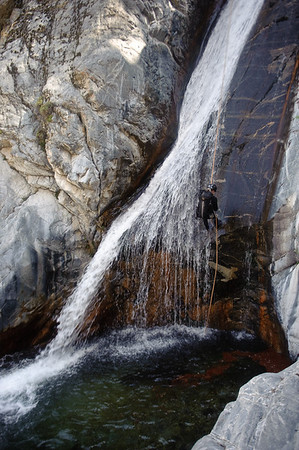
Canyoneering:Suicide canyon(Big Tujunga)
http://canyonaddict.blogspot.com/2009/0 ... ssues.html
"So! We're all down. Start pulling the pull line down. 20 feet later... BAM stuck"

Angeles Forest Exploring(Santa Clara divide and north Angeles Forest)
http://www.adventureduo.com/2009/05/ang ... oring.html
User avatar
simonov
Posts: 1087
Joined: Tue Nov 27, 2007 5:44 pm
Location: Reno, NV
Contact:

Post by simonov »

AW wrote:Icehouse Canyon to Cucamonga Peak
http://www.ephonium.com/greetingsfromla/?p=1120
"But fortunately, flickr comes to the rescue, and a search yielded some great pics by simonov that are representative of my experience".....
Damn, it's good to be king!
Nunc est bibendum
User avatar
AW~
Posts: 2040
Joined: Mon Oct 01, 2007 12:00 pm

Post by AW~ »

bear in Pasadena
http://eastofallen.blogspot.com/2009/06 ... -bear.html

Rescue team saves injured hiker near Strawberry Peak Trail
http://www.sgvtribune.com/news/ci_12547791?source=rss
"The hiker was near Strawberry Peak Trail when she fell and was possibly injured," Sheriff's Department officials said.

Another hiker heard her calling for help at about 6:15 p.m. and notified authorities, officials said"

Judge finds violation in Calif. forest planning
http://blog.taragana.com/n/judge-finds- ... ans-78063/
"Federal agencies violated the Endangered Species Act by developing plans for four national forests in California without adequately addressing the impact on endangered animals, a judge ruled....The judge’s order will require estimates of how forest projects may harm endangered or threatened plants and animals such as the California condor and the gnatcatcher"

Our View: Highway 2 revisited
http://www.sgvtribune.com/opinions/ci_12423112
"Now, as long as we're talking closed state highways, this would be a perfect time to nudge Caltrans about finishing repairs on State Highway 39, which has been closed at Mountain Springs - about 40 miles north of Azusa - since 1978. Yes, for more than three decades, travel from the heart of the San Gabriel Valley into Wrightwood or Table Mountain has been prohibited due to road wash-outs.

The opening of Highway 2 all the way through sets a precedent for the reopening of Highway 39 through the mountains, for recreation and even for evacuation purposes in case of an emergency. That should be next on Caltrans' list. "

Azusa water company gets its fill with new plant
http://www.sgvtribune.com/news/ci_12542127
"The old plant was constructed in 1963 and filtered water with sand, Hsu said. The new plant uses a high-tech fiber as it's main filtration, Hsu said....The project is being paid for by bonds issued in 2006 that will be repaid over 30 years, Hsu said"

Modern day gold prospectors(photos essays of the East Fork San Gabriel river)
http://www.time.com/time/photogallery/0 ... 49,00.html

PCT Little Jimmy project(other projects as well)
http://www.volunteermatch.org/search/opp480141.jsp
"For the Little Jimmy Project in the Angeles National Forest, volunteers will be re-digging tread, building rock retaining walls and constructing drainage features using both rock and timber"

conditions Eaton canyon: http://carbonaspect.com/blog/index.php/ ... on-canyon/
User avatar
Taco
Snownado survivor
Posts: 6010
Joined: Thu Sep 27, 2007 4:35 pm

Post by Taco »

I'll make a guess as to the cost of rebuilding R39...

Eleventy BILLION dollars.

Sounds like a HORRIBLE time to rebuild that stretch of road.
User avatar
Cy Kaicener
Posts: 163
Joined: Fri Sep 28, 2007 5:19 am

Post by Cy Kaicener »

A hiker falls on the cables of Half Dome during a storm
http://www.summitpost.org/phpBB2/viewtopic.php?t=46224
User avatar
AW~
Posts: 2040
Joined: Mon Oct 01, 2007 12:00 pm

Post by AW~ »

Eaton Canyon Falls Graffiti Survey
http://blog.stonehillnews.com/2009/06/e ... survey.htm


conditions...
Santa Anita Canyon
http://blog.unworn.nu/2009/06/saturday- ... anyon.html
Alder Creek
http://veloracat.livejournal.com/56360.html
Camp Glenwood(Little Rock creek)
http://birdyandhemlockmuppet.com/2009/0 ... -mile-400/

blog: general nature/wilderness
http://wildrye.com/

covers a lot of Ventury county trails
http://wildrye.com/?cat=59

incidents(had been quiet recently besides the BBQs&parking):
06/14/2009 21:19 SAR Trail b/t Echo Mtn. & Inspiration Point
06/14/2009 16:53 Vehicle Break In Hidden Springs Picnic Area
06/13/2009 11:43 Cliff rescue--fell/injured Chantry Flats area 1/4 mile fr. gate, up the canyon
06/13/2009 12:35 Unconscious Female Medical Aid east fork rd/end
User avatar
AW~
Posts: 2040
Joined: Mon Oct 01, 2007 12:00 pm

Post by AW~ »

OT: SAR - God bless em
New Mexico:State Police Release 911 Rescue Tapes
http://www.koat.com/news/19785626/detail.html
"Eventually, Andy Tingwall(rescue state police) finds Yamamoto(lost hiker) and carries her on his back to the helicopter.
By this time, nearly five hours has elapsed since Yamamoto's first call to 911 and just minutes after the helicopter took off to try to fly out of the mountains it crashed in the rough weather."

Addntl coverage:
http://www.santafenewmexican.com/Local% ... -writethru

incidents...
06/19/2009 Bear sightings 265 No. Mountain trial, Altadena, CA 91024
06/20/2009 17:17 Vehicle Break In East Fork Rd. 0.25 miles E/O LAC Camp 19
06/21/2009 13:10 Vehicle Broken into - clear creek
06/21/2009 09:21 Lost Mtn Biker Search & Rescue Mt Lowe Motorway near Alpine Tavrin

Update on graffiti at Eaton Canyon
http://www.altadenablog.com/2009/06/upd ... anyon.html
"While the park's area was cleaned up (i.e. painted over) fairly quickly, the National Forest Service land apparently still has tagging, and the Eaton Park staff have no jurisdiction over it.

In addition, the complaints about the graffiti, and phone calls seeking information and offering help, have made it difficult for the budget-squeezed Eaton Park staff to do the other jobs they're supposed to do"

Murder charged in SoCal deadly runaway truck crash
http://www3.signonsandiego.com/stories/ ... california
"PASADENA, Calif. — An indictment unsealed Friday brought murder charges against the driver of a big-rig that lost its brakes while descending a steep mountain grade north of Los Angeles and hit a car, killing a father and his 12-year-old daughter. "

Historical(2006):Driving the Angeles Crest


blogs/current conditions/tr:
Down the East Fork
http://www.sandiegoreader.com/news/2009 ... east-fork/
"At “the Narrows” of the East Fork, the water squeezes through the deepest gorge in Southern California, rising 5200 feet high on the east side and 4000 feet high on the west side"

Hiking Mount Baden-Powell
http://www.modernhiker.com/2009/06/18/h ... en-powell/

Camping in the Los Angeles Crest National Forest(Buckhorn,Cooper Canyon Falls)
http://ladylibby.blogspot.com/2009/06/c ... st_08.html

Switzer
http://www.100hikes.com/blog/?p=267

San Andreas Fault
http://todaysworldrealestate.blogspot.c ... dreas.html
"The whole segment of the fault line shown here last ruptured during the Fort Tejon earthquake of 1857. One of the largest recorded earthquakes in the US, it left an amazing 350 km surface rupture scar along the San Andreas. Were the Fort Tejon shock to occur today, the results could be catastrophic."

LA Magazine 10 great hikes - July issue(pretty much a teaser for their issue with little to no details)
http://www.lamag.com/issue.aspx?id=16928
User avatar
AW~
Posts: 2040
Joined: Mon Oct 01, 2007 12:00 pm

Post by AW~ »

Pico Rivera man killed, three others injured, in crash north of Azusa
http://www.insidesocal.com/sgvcrime/200 ... ree-o.html
"A young Pico Rivera man was killed and three others were injured late Tuesday after a car they were in drove off the edge of Highway 39 north of Azusa, authorities said"

5 lost hikers found by sheriff's helicopter in Modjeska Canyon
http://www.ocregister.com/articles/hike ... iff-jansen
"MODJESKA CANYON – Officials used two helicopters to rescue five hikers who became lost and panicked in Modjeska Canyon today, authorities said"

motorcycle riding the ACH
http://www.pashnit.com/forum/showthread.php?t=23129

New District Ranger for Angeles National Forest
http://beaconmedianews.com/2009/06/25/n ... al-forest/
"Bob Blount begins this month as one of three district rangers on the Angeles National Forest. In his new position, Blount will oversee operations on the Santa Clara-Mojave Rivers Ranger District, which stretches from Interstate 5 between Castaic and Pyramid Lake, east to Wrightwood, CA, on the north side …"

O/T: Good ole Tenaya Creek(Yosemite)
http://kineticinstasis.blogspot.com/200 ... creek.html
User avatar
AW~
Posts: 2040
Joined: Mon Oct 01, 2007 12:00 pm

Post by AW~ »

Altadena blog adds to hiker rescue at Dawn Mine(note hikers called for help on cellphone):
http://www.altadenablog.com/2009/07/cop ... rnoon.html

I'm soo done with ACH
http://www.ducati-superbikes.com/forum/ ... hp?t=17157
also contains "California Legislators Prepare to Unleash Speed Traps in Pasadena"

Ontario and Bighorn Peaks - 6/25/09
http://socalpeakbagger.blogspot.com/200 ... peaks.html

O/T:Wildfires burning in Yosemite National Park nearly out
http://blogs.pe.com/news/digest/2009/07 ... emite.html
"Nearly 500 firefighters have all but put out two lightning-sparked wildfires that caused trail closures and obscured views inside Yosemite National Park over the holiday weekend"

Yahoo Q: I live in the San Fernando Valley and I have no idea where there would be a place to find gold. I've heard that the San Gabriel mountains have gold in them but I do not know what part to go to. If you know of any places to find gold, please tell me. I am not going to share it with anybody but myself. Thank you, best answer gets 10pts.
Yahoo A: Knottsberry Farm

Little Tujuga fire video
http://vinnyswebsite.com/blog1/video-wi ... 09-youtube
User avatar
Taco
Snownado survivor
Posts: 6010
Joined: Thu Sep 27, 2007 4:35 pm

Post by Taco »

Pretty stupid regarding that ticket the biker got. Not surprised. I love how he asked the officer, "How do you sleep at night?"

Guess I'll go slow unless there's snow on the road. Fly through there in the winter. "You're going too fast!" Uh... no. Too fast = you can't handle it. CANNOT stand how righteous people seem when they say someone is going too fast. Good Christ people, lay the f*ck off.
User avatar
kgw
Posts: 133
Joined: Fri Jul 18, 2008 11:48 am

Post by kgw »

Ducati Data System...I love it! I think I'll leave my gps plugged into my car when in revenue enhancement areas :twisted:

"My DDA came in handy this week. I was pulled over for speeding (which I wasn't) by the Military police( I was on base). They claimed I was speeding 45 in a 35 and I knew I wasn't becaue I was in 3rd gear cruising...I asked them how they determined my speed and they said that they got me with their radar gun.. I told them they needed to call thes hift supervisor and have him come so I can prove them wrong. When he arrived they explained what was going on and he seemed upset at me. He asked why I requested him since I was going to get the ticket anyway. I explained I can prove his people wrong..he laughed and asked how? I asked to pul out my computer.. He looked puzzeld and said ok.. I pulled it out turned it on and pulled out my DDA..he was realy confused now and he was asking what that was...I explained that it was a data logger and would tell me what speed I was at at the time they "gunned me" I got it all up and showed him everything...At the time they claimed they gunned me, the DDA claimed I was in 2nd gear doing 24mph.... and that my top speed( from the time I got on to the base) was a max of 33mph....He was thoroughly impressed and I got out of my ticket."
Post Reply