
SR-39 (San Gabriel Canyon Road)
-
Taco

- Snownado survivor
- Posts: 6218
- Joined: Thu Sep 27, 2007 4:35 pm
Broken English my ass. They owe Adam an apology for that comment.
-
Hikin_Jim

- Posts: 4688
- Joined: Thu Sep 27, 2007 9:04 pm
Fascinating. First they're going to re-open the long-closed upper section, and now they want to abandon not only the upper section but the entire route.
Maybe CalTrans is bipolar?
HJ
Maybe CalTrans is bipolar?
HJ
-
Taco
- Snownado survivor
- Posts: 6218
- Joined: Thu Sep 27, 2007 4:35 pm
Sounds like the government to me!
-
moppychris

- Posts: 87
- Joined: Mon Sep 07, 2009 12:56 pm
Well here in LA, if you don't have a latino or asian accent, you are the odd one out. Thus, Adam appears to have "broken english".
-
AW~

- Posts: 2125
- Joined: Mon Oct 01, 2007 12:00 pm
CalTrans is the biggest slumlord in the state and is the one that needs to be abandoned
http://www.caltranstenants.com/slumlord.html
http://www.caltranstenants.com/slumlord.html
-
AW~
- Posts: 2125
- Joined: Mon Oct 01, 2007 12:00 pm
http://caltransd7info.blogspot.com/2016 ... osure.html
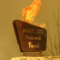
"Caltrans will continue to restrict access to San Gabriel Canyon Road (SR-39) due to mud slides and road washouts caused by early January rains in the Cabin fire burn area in the Angeles National Forest. The closure is just north of East Fork Road, 13 miles north of the Foothill Freeway (SR-210). The closure is expected to be in place for several weeks.
Caltrans damage assessment coordinators and geotechnical technical team are in the process of:
Developing repair solutions and hiring a contractor to rebuild three damaged sections of highway.
Clearing debris basins alongside the highway for future storms.
Rebuilding and stabilizing the slopes above and below the highway.
Securing permits from Angeles National Forest, California Fish and Wildlife, California Regional Water Quality Control Board, and US Waterways to begin repairs. "
-
Sean

- Cucamonga
- Posts: 4420
- Joined: Wed Jul 27, 2011 12:32 pm
This is a good example of what I was saying in the other thread about the lack of private development in the forest resulting in a lack of government resources devoted to protecting it. If there were a small village in the Crystal Lake basin, then these government agencies would be hearing an earful on a daily basis from hundreds of irate residents clamoring for critical, public services like simply maintaining the debris basins and storm channels. Instead we have one small business owner, weeks after the fact, pleading with hiker-tourists for help in dealing with several different government entities who clearly see little urgency in the matter.
-
AW~
- Posts: 2125
- Joined: Mon Oct 01, 2007 12:00 pm
This one is pretty simple IMO....and not a good example. A storm on a recently burned sizable area ruined a piece of Highway 39. Theres no way anyone is going to fix anything until after the rainy season, nor should they. And with Caltrans operating under the assumption of El Nino saturated storms coming, that makes it 101% they wont move an inch on it, nor would they if there were a small village. The section from Crystal Lake to Highway 2 would be a better example, but there are plenty of voices supporting the fixing of that section already.
The operator should have known this would happen...and will happen again.
The FS plans to renovate the old campgrounds and spend millions....so it is in fact the public that recognizes the importance of Crystal Lake for recreation and wants the road opened. Its just that the history of Caltrans is ignoring millions of people and not investing in mountain highways.
-
Sean
- Cucamonga
- Posts: 4420
- Joined: Wed Jul 27, 2011 12:32 pm
Yes, they would. A village buried in snow and isolated from the rest of civilization would be considered a public emergency. They would either fix the road within days, evacuate the village, or indefinitely supply necessities by chopper. I'm guessing they'll fix the road as quickly as possible.AW wrote: And with Caltrans operating under the assumption of El Nino saturated storms coming, that makes it 101% they wont move an inch on it, nor would they if there were a small village.
-
AW~
- Posts: 2125
- Joined: Mon Oct 01, 2007 12:00 pm
Crystal Lake was supplied by auto from the lower end. In the areas where the highway was gone, they put the supplies on wagons...then switching back to auto for the next section,etc. By that year of course the Solider Creek development had been long evacuated from the Curve fire.Sean wrote: Yes, they would. A village buried in snow and isolated from the rest of civilization would be considered a public emergency. They would either fix the road within days, evacuate the village, or indefinitely supply necessities by chopper. I'm guessing they'll fix the road as quickly as possible.
Yeah, they fixed the lower section ASAP...as in 2 years lol. Within days? Impossible....and to top it off it was raining everyday for months and got worse and more highway defects. These clowns are planning for 1997-1998...Feb to be 13 inches of LA downtown rain. And if that happens, this defect will be just one of many.
-
dima

- Posts: 1933
- Joined: Wed Feb 12, 2014 1:35 am
- Location: Los Angeles
Has anyone heard anything about when the road to Crystal Lake will reopen? Don't want to get into a political discussion here, just want to know about the road 
-
AW~
- Posts: 2125
- Joined: Mon Oct 01, 2007 12:00 pm
-
AW~
- Posts: 2125
- Joined: Mon Oct 01, 2007 12:00 pm
http://www.sgvtribune.com/general-news/ ... nal-forest
"...The robbery happened at mile marker 23 on Highway 39 at about 3:30 a.m.
Berg said a 19-year-old West Covina man and a 20-year-old West Covina woman were in a parked car when a man and a woman in their 20s approached them.
The man, who carried a shotgun, demanded the victims’ property and took a wallet, a phone and car keys, according to Berg...."
Hwy39 also saw a perplexing overnight stay by a hiker
http://www.sgvtribune.com/general-news/ ... nal-forest
"...Lt. Andy Berg of the sheriff’s San Dimas station said the woman, her 25-year-old brother and her 12-year-old brother went hiking Sunday in an area past mile marker 28 on Highway 39. He said they were hiking off trail and went to a lookout. While hiking back, Berg said the woman slipped on a rock and broke her arm. The siblings decided to spend the night in the forest, he said. Berg didn’t know if the three had any camping equipment.On Monday, he said the older brother went back to the car and drove to an Azusa police station where he sought help...."

-
AW~
- Posts: 2125
- Joined: Mon Oct 01, 2007 12:00 pm
This article was closed out
http://www.sgvtribune.com/general-news/ ... -mountains
http://www.sgvtribune.com/general-news/ ... -mountains
By Stephanie K. Baer, The San Gabriel Valley Tribune
Posted: 05/02/16, 2:37 PM PDT | Updated: 2 hrs ago
0 Comments
Authorities have arrested two suspects and recovered property in connection with three armed robberies in the San Gabriel Mountains last month.
Between April 15 and April 30, deputies received reports of three separate armed robberies near Highway 39 in the San Gabriel Mountains, according to a statement from the Los Angeles County Sheriff’s Department San Dimas station.
In each incident, a male and female armed with a shotgun approached victims parked in roadside turnouts and stole purses, cell phones, wallets and other personal property.
The suspect vehicle described in each robbery was a white cube-style small SUV.
After receiving the report of the third robbery at about 3 a.m. on Saturday, deputies located the suspect vehicle on Highway 39 near mile marker 19. The car, a white 2010 Scion XB, had been involved in a single-vehicle crash with a guard rail, authorities said.
Deputies detained the male and female occupants of the vehicle.
Victims of the third robbery identified both suspects. Juan Manuel Plazola, 20, of La Puente, and Deanna Marie Campillo, 23, of El Monte, were in possession of a shotgun, a replica pistol and stolen property at the time of their arrest. Detectives later obtained a warrant to search for evidence in the suspect’s vehicle and located property reported stolen in the previous robberies.
Plazola was booked on suspicion of armed robbery at the San Dimas station and held in lieu of a $100,000 bail. Campillo was booked on suspicion of armed robbery at the Century Regional Detention Facility and held in lieu of a $100,000 bail.
The two were scheduled to appear in court on Tuesday.

-
SGBob
- Posts: 101
- Joined: Wed Jan 07, 2015 12:47 pm
Surprise surprise. This guy has two prior felonies and was last sentenced to two years in January 2015, but apparently he got an early release and was released in October. Hopefully this counts as his third strike. The girl also has a prior felony arrest but apparently the charges were dropped. Go justice system!
-
Slowest_Hiker
- Posts: 283
- Joined: Sun Jul 31, 2011 12:31 pm
Caltrans considering a new plan to reopen Highway 39 all the way to Wrightwood
Congestion in the North, West and East forks of the San Gabriel River — popular recreation spots during summer and fall — would be relieved by completing the loop to Highway 2, moving people and traffic through Wrightwood, a quaint mountain town, and connecting to the high-desert communities.
-
psykokid
- Posts: 80
- Joined: Fri Mar 18, 2016 1:15 am
About dam time.. Would be nice to not have to drive all the way around to access BP and the environs.
-
Ze Hiker

- Posts: 1432
- Joined: Mon Jul 28, 2008 7:14 pm
Ridiculous. There is no benefit to access to Wrightwood, as it is already faster to take 210 - 15 - 138 to get there than it would be up the slower, curvy, steep mountainous 39 - 2 route.
The only benefit would be a 10-20 minute drop in time for people in Azusa / Glendora to get up to the upper ACH trailheads (i.e. Waterman, Kratka, Islip, etc...). Other cities west it would be faster to access ACH from La Canada anyways.
The only benefit would be a 10-20 minute drop in time for people in Azusa / Glendora to get up to the upper ACH trailheads (i.e. Waterman, Kratka, Islip, etc...). Other cities west it would be faster to access ACH from La Canada anyways.
-
Sean
- Cucamonga
- Posts: 4420
- Joined: Wed Jul 27, 2011 12:32 pm
What about during rush hours? A lot of people take the AFH to Palmdale to avoid the 5 freeway. Maybe some would take 39 to bypass Cajon Pass.Zé wrote: Ridiculous. There is no benefit to access to Wrightwood, as it is already faster to take 210 - 15 - 138 to get there than it would be up the slower, curvy, steep mountainous 39 - 2 route.
-
AW~
- Posts: 2125
- Joined: Mon Oct 01, 2007 12:00 pm
Relying on one narrow mountain highway, when you have another one built is plain loco. Another one whose missing segment that is technically illegal to be on I should mention.Zé wrote: Other cities west it would be faster to access ACH from La Canada anyways.
Id say a deal is in order, where Caltrans agrees to spend $X each year on the highway 39, and any unused funds get saved. If it does rain this year, you can forget about the last segment, and the possibility of a long closure of the segments affected by the recent fires....but if we dont get any damage by April, they should start up Highway 39.
-
Hikin_Jim
- Posts: 4688
- Joined: Thu Sep 27, 2007 9:04 pm
You've got to be kidding. Hwy 39 is technically infeasible unless you're going to be willing to spend a lot of money -- as in rebuilding the highway nearly every year.
The West face of Mount Islip is one big land slide. Well, OK, not quite, but pretty close. It's constant rock fall along there.
If they really need a highway in there, they need to go over Windy Gap and abandon Islip Saddle as a route.
HJ
The West face of Mount Islip is one big land slide. Well, OK, not quite, but pretty close. It's constant rock fall along there.
If they really need a highway in there, they need to go over Windy Gap and abandon Islip Saddle as a route.
HJ
-
Ze Hiker
- Posts: 1432
- Joined: Mon Jul 28, 2008 7:14 pm
Just because something is partially built, doesn't mean you have to keep it up. It doesn't make financial sense. The phrase "cut your losses" applies here.
These mountain roads aren't intended to be congestion-reducing throughputs, they are to provide access to nature. Constant costly upkeep of upper 39 in order to save some people 10 minutes off their drive to nature is not something taxpayers should paying for. If you wanted to make it a toll road, maybe. But I doubt that would work as the "demand" for it is fake.
These mountain roads aren't intended to be congestion-reducing throughputs, they are to provide access to nature. Constant costly upkeep of upper 39 in order to save some people 10 minutes off their drive to nature is not something taxpayers should paying for. If you wanted to make it a toll road, maybe. But I doubt that would work as the "demand" for it is fake.
-
AW~
- Posts: 2125
- Joined: Mon Oct 01, 2007 12:00 pm
We'll see. They thought they were going to get away with closing Hwy39 at West Fork and then they thought they were going to get away with closing Hwy39 at the Valley of the Moon. A whole generation of wasted time, but just in time for the eastern half of the forest to be saved from the Station Fire.Zé wrote: Just because something is partially built, doesn't mean you have to keep it up. It doesn't make financial sense. The phrase "cut your losses" applies here.
These mountain roads aren't intended to be congestion-reducing throughputs, they are to provide access to nature. Constant costly upkeep of upper 39 in order to save some people 10 minutes off their drive to nature is not something taxpayers should paying for. If you wanted to make it a toll road, maybe. But I doubt that would work as the "demand" for it is fake.
Cant blame them I guess...they got away with not fixing GMR for 30 years with the same lies. And then a few months later its lasted for 10+ years with no incidents thus far. Granted it might be confusing which was the unnecessary one..GMR or Hwy39? Hwy 2 or Hwy 39? If we are going by cost, Hwy2 should have been abandoned a log time ago. In fact, the #2 from Little Jimmy eastward with that crackerjack coating they spent millions on looks like someone travelled it pogo-ing every which way with a jackhammer(OK it was likely the rock runs). Is the centerline still visible?
-
Gene

- Old Dam Man
- Posts: 219
- Joined: Mon Dec 26, 2011 7:54 pm
It may be a straw man ploy to get funding:
"We need a lot of funding to fix this route, but hey, we can save $.02 by cutting thru a protected area."
"We need a lot of funding to fix this route, but hey, we can save $.02 by cutting thru a protected area."
-
RichardK

- Posts: 727
- Joined: Sun Sep 30, 2007 12:33 pm
Read the article carefully. It does not say that any course of action is definite.
If anything half way concrete appears, expect an avalanche of environmental law suits over the impact to Nelson's Bighorns.
I will be dead of old age first.
They aren't actually doing a design or studies. They are just "preparing" to do them. It sounds like a smoke screen. The various city governments in the area are clamoring for the road to re-open. So, Caltrans makes like it is doing something just to shut them up.“We are preparing the engineering design and environmental studies in support of this effort,” said Lauren Wonder, a Caltrans spokeswoman, in an email.
If anything half way concrete appears, expect an avalanche of environmental law suits over the impact to Nelson's Bighorns.
I will be dead of old age first.
-
robow8
- Posts: 43
- Joined: Wed Oct 12, 2016 4:14 pm
My brother is a civil engineer for caltrans. I'll have to ask him about it.