
http://socalhikes.com/2010/09/east-fork-to-fish-fork/
went on trip with Taco and Zach trying to get their gear back. Wasn't with them up the last part up the falls so stay tuned for their more interesting report!
East Fork to Fish Fork
-
Zach

- Posts: 522
- Joined: Sun Jan 04, 2009 4:25 pm
I'm just gonna piggyback on this TR since I'm too lazy to make my own.
I had never been past the narrows and was pleasantly surprised by the beauty of the area. There was a really cool section where the steep canyon walls were overhung with moss-covered stalactites dripping with moisture. I thought it was peculiar given how dry most of the San Gabriels can be during the summer months.
Patrick, Ryan and I split off to hike up the Fish Fork after hiking in with Johanna and Ze to it's confluence with the East Fork of the San Gabriel River. I want to stop here to touch upon my nasty habit of constantly UNDER-estimating my various adventures. It's funny because not a week earlier we had been tested by this canyon and were now returning to collect the remnants of gear that were left behind from that debacle. The beta we had, I felt, did not prepare us for what we encountered. The 1.5 miles that we allegedly had to travel was through the most dense (and wet) terrain possible. Slow-going would be an understatement.
I started laughing to myself when I read Ze's report and saw the picture of the "fork" in the canyon... yeah that's right, we went up the wrong one. The fork is not so obvious when you come up to it due to the dense forest. We hiked for a few minutes before becoming suspicious of our whereabouts. The creek bottom had a distinctively different (clay-like) covering, and we could now look up and see the summit of Iron Mountain?! WTF! Ryan scrambled up onto the canyon's ridge and confirmed that we had indeed taken a wrong turn. We down-climbed the short section and resumed our trek.
Fast forward a few treacherous hours and we came to the impasse of the first waterfall. On our first adventure (after extricating ourselves from the situation) we had proceeded down-canyon and had indeed rapped down a waterfall that I HOPED would be the same waterfall mentioned in the beta... no such luck. It was ~1330 and everyone was pretty beat. I was frustrated... no I was PISSED that we had come this far just to be turned around by this obstacle. We started back down the canyon and as we passed the ridge that made one side of the canyon I saw what I thought could be a possible bypass to the waterfall. Patrick agreed to wait until 1430 while Ryan and I exhausted this final option. We worked our way up this very steep ridge and emerged on a spur... with a view of our gear!!!!! We were still about 1/4 of a mile away and were cliffed out on the side so we kept hoofing it up the ridge until the cliff ended and allowed us to traverse across and down the same scree slope I had taken from the opposite direction a week earlier. Along the ridge I was able to raise Johanna on the radio and told her we would be (very) late and that Patrick would most likely be returning before us.
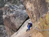
We found the gear cache, strapped on our harnesses, and headed down canyon. We encountered 1 rappel, a really sweet jump, and the final falls which we half rappelled, half jumped. From there on out we maintained a slow and steady pace until finally emerging at the Fish Fork camp around 1800.
Patrick was there along with another group of backpackers who were most gracious and provided us with delicious hot coffee and gummy worms. Tasted DE-lish! Thanks guys! Apparently Ze's exploits are quite renown around these parts and they were surprised to find he had graced the area with his presence earlier that day
The rest of the trip was pretty uneventful and consisted of mainly a bunch of SUCK, route-finding in the dark, and then more SUCK from exhaustion. We arrived back at the cars right after 2230. A great big thank you to Ze and Johanna for the moral support and spare gear. Special thanks to Patrick for slugging it out with us and helping with the load on the way out. You rock!
Moral of the story: I'm not going back to the Fish Fork. Unless maybe you paid me. Also, for future adventurers, give yourself 3 days to do the entire canyon. And send your strongest swimmer down first on the big falls.
Taco can probably give accurate stats on total amount of raps and what-not. Just FYI, all the mandatory raps now have new webbing and rap rings
I had never been past the narrows and was pleasantly surprised by the beauty of the area. There was a really cool section where the steep canyon walls were overhung with moss-covered stalactites dripping with moisture. I thought it was peculiar given how dry most of the San Gabriels can be during the summer months.
Patrick, Ryan and I split off to hike up the Fish Fork after hiking in with Johanna and Ze to it's confluence with the East Fork of the San Gabriel River. I want to stop here to touch upon my nasty habit of constantly UNDER-estimating my various adventures. It's funny because not a week earlier we had been tested by this canyon and were now returning to collect the remnants of gear that were left behind from that debacle. The beta we had, I felt, did not prepare us for what we encountered. The 1.5 miles that we allegedly had to travel was through the most dense (and wet) terrain possible. Slow-going would be an understatement.
I started laughing to myself when I read Ze's report and saw the picture of the "fork" in the canyon... yeah that's right, we went up the wrong one. The fork is not so obvious when you come up to it due to the dense forest. We hiked for a few minutes before becoming suspicious of our whereabouts. The creek bottom had a distinctively different (clay-like) covering, and we could now look up and see the summit of Iron Mountain?! WTF! Ryan scrambled up onto the canyon's ridge and confirmed that we had indeed taken a wrong turn. We down-climbed the short section and resumed our trek.
Fast forward a few treacherous hours and we came to the impasse of the first waterfall. On our first adventure (after extricating ourselves from the situation) we had proceeded down-canyon and had indeed rapped down a waterfall that I HOPED would be the same waterfall mentioned in the beta... no such luck. It was ~1330 and everyone was pretty beat. I was frustrated... no I was PISSED that we had come this far just to be turned around by this obstacle. We started back down the canyon and as we passed the ridge that made one side of the canyon I saw what I thought could be a possible bypass to the waterfall. Patrick agreed to wait until 1430 while Ryan and I exhausted this final option. We worked our way up this very steep ridge and emerged on a spur... with a view of our gear!!!!! We were still about 1/4 of a mile away and were cliffed out on the side so we kept hoofing it up the ridge until the cliff ended and allowed us to traverse across and down the same scree slope I had taken from the opposite direction a week earlier. Along the ridge I was able to raise Johanna on the radio and told her we would be (very) late and that Patrick would most likely be returning before us.
We found the gear cache, strapped on our harnesses, and headed down canyon. We encountered 1 rappel, a really sweet jump, and the final falls which we half rappelled, half jumped. From there on out we maintained a slow and steady pace until finally emerging at the Fish Fork camp around 1800.
Patrick was there along with another group of backpackers who were most gracious and provided us with delicious hot coffee and gummy worms. Tasted DE-lish! Thanks guys! Apparently Ze's exploits are quite renown around these parts and they were surprised to find he had graced the area with his presence earlier that day
The rest of the trip was pretty uneventful and consisted of mainly a bunch of SUCK, route-finding in the dark, and then more SUCK from exhaustion. We arrived back at the cars right after 2230. A great big thank you to Ze and Johanna for the moral support and spare gear. Special thanks to Patrick for slugging it out with us and helping with the load on the way out. You rock!
Moral of the story: I'm not going back to the Fish Fork. Unless maybe you paid me. Also, for future adventurers, give yourself 3 days to do the entire canyon. And send your strongest swimmer down first on the big falls.
Taco can probably give accurate stats on total amount of raps and what-not. Just FYI, all the mandatory raps now have new webbing and rap rings
-
Tim

- Posts: 560
- Joined: Tue Apr 08, 2008 8:55 pm
Wow! I love reading this stuff. The San Gabriels never cease to amaze me in how inhospitable they can be. Fish Fork is legendary! ...and apparently now so is Ze 
-
Ze Hiker

- Posts: 1432
- Joined: Mon Jul 28, 2008 7:14 pm
lol
"the ridge in the back descends from SA ridge, Taco, Zach, and Patrick should have gone left. With it taking me almost an hour to get 1/2 mile up the canyon, I knew it would be a loooong day for them (1.5 miles each way)"
I was somewhat concerned you guys could take the right fork, but I also thought it would be not as obvious as the left. guess not!
Also thought that 12 foot waterfall would be an issue
nice job getting your gear. must have been tough slog up the fork!
-
Zach
- Posts: 522
- Joined: Sun Jan 04, 2009 4:25 pm
We missed you out there. You would have loved the rappels!Johnny Bronson wrote:Good friends,good people :thumbup:
@Ze: As we climbed the ridge I thought about how much you would have relished the adventure. I'm ready for some "dry" hiking... maybe Triplet Rocks?
-
cougarmagic

- Posts: 1414
- Joined: Wed May 07, 2008 5:21 pm
OK, here is part III:
It started a few minutes before 6AM, on East Fork road. Some crazy guy comes screaming up the road behind me and I just barely have time to swerve into a turnout before they pass, waving enthusiastically out the sunroof.
Arriving to an already full parking lot at Heaton at 6am was a surprise! Taco and Ze were already there (hmmm...). Zach and Patrick arrived in minutes, and with a sense of excitement and urgency, we started covering the easy miles to the Bridge to Nowhere.
I really don't see how people bungee jump off this thing:

This flower was huge! And I've never seen it before:

Was there some debate about which peak this is?:

Above the bridge, it gets super awesome:

Morale was high. These guys are always optimistic.
Where did Ze go???

Oh, there he is, taking a shortcut!
More beautifulness:

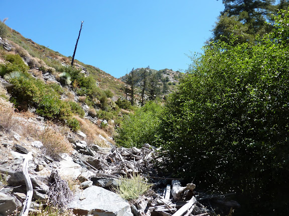
This is a very cool cliff face, with dripping travertine stalactites. Here we also started to follow mountain lion tracks, but they were in sand, and didn't show up well in photos.

Got great bighorn sheep tracks in mud though:

The hiking is on sections of decent trail, which sometimes disappears and gets a little tricky. Overall, we moved very fast through here.
The campsite at Fish Fork is really great - shady, cool, no bugs, and the nice sound of the stream nearby. I knew the guys were in for some less pleasant terrain, so I stayed here and took a nap! Watching them go, I really hoped they were going to make it to their stuff, because coming this far and having to turn back would be really awful!

Canyon gear:

After about an hour or so, I was happy to see Ze come back. We passed the time wondering what the other guys were encountering, and trying to guess how long it was going to take. When we heard from Zach on the radio at 2:00, and they were still headed up canyon, we knew it was gonna be a loonnnng time. We felt guilty about leaving, but neither of us were too excited about waiting there for three or four more hours, then hiking out in the dark. We actually had a great hike back, stopping for a quick swim in one of the pools, and talking about hiking physiology, wildlife, tracking, canyoneering, etc etc. Seeing (and hearing) the bats was really cool!!
Strangely, as we got close to the parking lot, we encountered several groups asking us if we knew "how to get back". This is always kind of a weird question in a canyon...! I mean, it does look different when you turn around, and the sun is in a different place, but there aren't a whole lot of options. ("Just make sure you don't suddenly turn and start climbing a cliff!) Oh well, I suppose I'm a bit of a snob...
As we got back to the car (about 6pm) Ze and I weren't so much worried for Zach, Taco, and Patrick's safety, but we did hope they weren't too miserable! Before we left, we let a ranger know there would be some guys coming out very late, and the ranger said he would be there all night, so that was reassuring.
Congrats guys - this was a huge accomplishment. This really is some of the roughest terrain in the already rough San Gabriels. It was fun to be a small part of it!
(And personally, I can't wait to canyoneer Fish Fork!)
(Oh, and by the way - not to rub it in that I had a fun day or anything, but I had these new waterproof neoprene socks. My feet stayed completely dry and comfortable all day long! It was awesome!!)
It started a few minutes before 6AM, on East Fork road. Some crazy guy comes screaming up the road behind me and I just barely have time to swerve into a turnout before they pass, waving enthusiastically out the sunroof.
Arriving to an already full parking lot at Heaton at 6am was a surprise! Taco and Ze were already there (hmmm...). Zach and Patrick arrived in minutes, and with a sense of excitement and urgency, we started covering the easy miles to the Bridge to Nowhere.
I really don't see how people bungee jump off this thing:
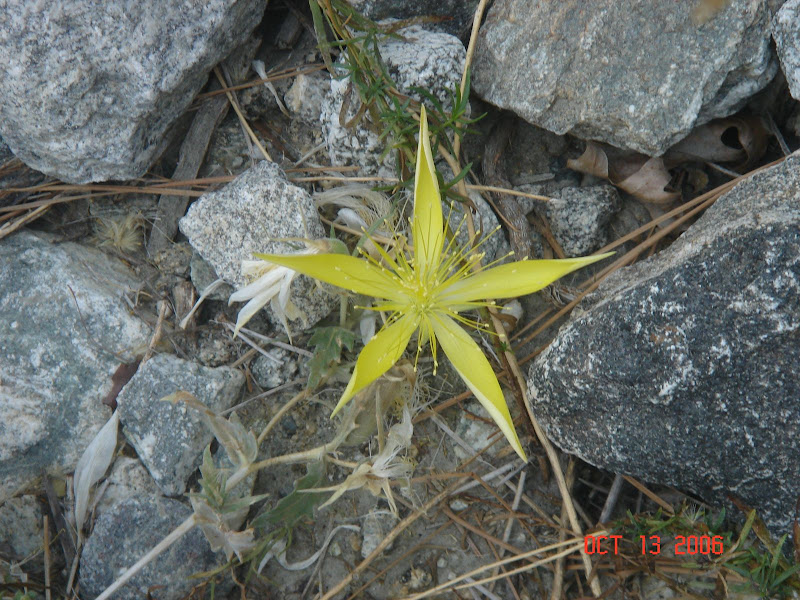
This flower was huge! And I've never seen it before:
Was there some debate about which peak this is?:
Above the bridge, it gets super awesome:
Morale was high. These guys are always optimistic.
Where did Ze go???
Oh, there he is, taking a shortcut!
More beautifulness:
This is a very cool cliff face, with dripping travertine stalactites. Here we also started to follow mountain lion tracks, but they were in sand, and didn't show up well in photos.
Got great bighorn sheep tracks in mud though:
The hiking is on sections of decent trail, which sometimes disappears and gets a little tricky. Overall, we moved very fast through here.
The campsite at Fish Fork is really great - shady, cool, no bugs, and the nice sound of the stream nearby. I knew the guys were in for some less pleasant terrain, so I stayed here and took a nap! Watching them go, I really hoped they were going to make it to their stuff, because coming this far and having to turn back would be really awful!
Canyon gear:
After about an hour or so, I was happy to see Ze come back. We passed the time wondering what the other guys were encountering, and trying to guess how long it was going to take. When we heard from Zach on the radio at 2:00, and they were still headed up canyon, we knew it was gonna be a loonnnng time. We felt guilty about leaving, but neither of us were too excited about waiting there for three or four more hours, then hiking out in the dark. We actually had a great hike back, stopping for a quick swim in one of the pools, and talking about hiking physiology, wildlife, tracking, canyoneering, etc etc. Seeing (and hearing) the bats was really cool!!
Strangely, as we got close to the parking lot, we encountered several groups asking us if we knew "how to get back". This is always kind of a weird question in a canyon...! I mean, it does look different when you turn around, and the sun is in a different place, but there aren't a whole lot of options. ("Just make sure you don't suddenly turn and start climbing a cliff!)
As we got back to the car (about 6pm) Ze and I weren't so much worried for Zach, Taco, and Patrick's safety, but we did hope they weren't too miserable! Before we left, we let a ranger know there would be some guys coming out very late, and the ranger said he would be there all night, so that was reassuring.
Congrats guys - this was a huge accomplishment. This really is some of the roughest terrain in the already rough San Gabriels. It was fun to be a small part of it!
(And personally, I can't wait to canyoneer Fish Fork!)
(Oh, and by the way - not to rub it in that I had a fun day or anything, but I had these new waterproof neoprene socks. My feet stayed completely dry and comfortable all day long! It was awesome!!)
-
lilbitmo

- Posts: 1092
- Joined: Tue Mar 04, 2008 9:44 pm
What a day - um - night  (Part IV)
Being the (almost) Senior Citizen of the group, I knew I was in for a crazy day with Zach and Taco, the description of where we were headed only added to my excitement - the kid in me sometimes forgets that he's dragging around an older person's body.
As mentioned by everyone the hike to the Bridge and the Narrows was relatively easy, from there it was in and out of the water as needed to access the trail on both sides of the river - having only been to the Narrows once before I was excited by the prospect of seeing what else was back in those canyons - having seen the canyon walls two winters before from the top of Rattlesnake and Iron is not the same thing as being in the bottom slugging through it all. Ze decided to climb up one of the ridges to scout future routes - I think it was the lower East slope of Ross but he has the GPS and can confirm that, he eventually rejoined us about a half mile before Fish Creek Camp.
Cougarmagic and I were out front of everyone for a bit and she was doing the usual tracking of animals, I was trying to identify a few but she's so adept at it I was fascinated by her ability to pick things out so quickly that I just enjoyed the lesson - thanks Johanna.
After a short break at the camp it was decided that Zach, Taco and I would keep moving up Fish Fork in hopes of finding the gear without too much trouble. We came across two forks in the river, the first one we made the right choice, the second we ventured up to the right only to backtrack as mentioned then proceeded up the correct one. Within another hour we came to a steep walled section with a waterfall dead in front of us, it stood about 15 feet above the surface of the water - I tried to swim to the right edge to see if I could use the chute on it's southeast face to climb up but no way. We got out of the water for 10 minutes to decide what to do? We fueled up and started to head back down stream, 5 minutes later Zach (still steaming from the fact we had come this far, knowing that we were extremely close to the gear) ask us if he and Taco could make an attempt at going up and over the ridge to get a visual - We all agreed and I looked at both of them and knew that I was the weak link, so I said have at it, I want you guys to get your gear, I'll wait here. Twenty minutes of climbing up the slope I could still see them, but I'm getting fairly cold from being in the water for the past 4 hours, so I started to up climb the slope to where I can see them topping out on the ridge. Once they reached the top I can see by all the pointing and arm movements that they see something familiar, I climbed further up the slope to get out of the shade cast by the northeastern slope of Iron Mountain and inside the sunlight (approximately 300 feet), I waited there until the agreed upon time for them to return and knew that if and when they came back with their gear that they were going to want to fly downstream, being the slower one it was prudent that I get going, so off I took back towards Fish Creek Camp.
Another 2.5 hours later of slugging back down stream I finally came to the fork for Fish Creek and the East Fork of the San Gabriel at Fish Fork Camp only to find that Johanna and Ze had gone back to Heaton Flats but had left a note (with some of the extra gear that Taco and Zach had left behind) four campers had come along and were setting up camp for the night. They had the note in hand and the gear and promptly handed me everything, then they became instant friends when they offered me a "Hot Cup of Coffee" and pumped fresh water through a filter for me - Thanks Scott, Mike, Kevin and ? I was really feeling the effects of being water soaked for 6.5 hours so the break and coffee gave me a new found happiness. The conversation with these campers also allowed me to focus on something other than, should I wait her or pack up everything and keep moving down stream (for anyone who's ever waited in the wilderness by themselves time ticks be very slowly and the mind starts to imagine all kinds of weird scenario's). Right about the time I was ready to throw in the towel and head back to Heaton Flats I hear some joyfull shouts from the the river and there stood Zach and Taco happy a pigs in shit, all their gear strapped on their packs. I cannot begin to tell you how happy I was for them, there's nothing more frustrating to get that close to recovering something that means so much to you, only to be stopped at the 11th hour - nice work Taco and Zach for not giving up so close to the goal line.
After getting more coffee from the campers and learning that the one gentleman is an avid fan of all the "Mining Hikes/Climbs" that Ze has done in the area, that camper was truly dissappointed for having missed Ze by a mere one hour or so - Ze you have a fan out there. This group likes to do canyon and caves, so they were explaining to me all the in-and-outs of that kind of fun - thanks to all of them for the coffee, conversation and knowledge I very grateful for all of it.
It was time for us to push back down canyon to the trialhead. We were all beat up but knowing we had to make fast tracks before one of our loved ones sent another "Crew" in to get us we sucked it up and just did the best we could not to complain. Darkness fell upon us before we reached the Narrows, there were at least 5 or 6 groups on "Miners" with their night lights on (and Campfires going) so every-so-often we'd come around and bend to find them "Mining at night" strange stuff for me, I didn't realize folks did that. Some of them were a little indignant about us passing by in the dark and shined their lights right in our faces - that was a little irritating.
By the time we passed the gate at Heaton Flats we were all done - stick a fork in us, you never saw three guys more happy to take off wet shoes, packs and just be able to sit down .
.
For me this may have been the most physically demanding day in my adult life - walking through a stream/river/creek call it what you like is extremely demanding physical work. Going upstream you fight the current, slippery rocks, overhanging vegatation just to name a few of the dangers. Coming downstream you have the constant tendency to slip with your feet going out from under you and falling backwards into the rocks you just want over, at one point my boot got locked between three rocks as I stepped down over a 18 inch waterfall and it took 5 minutes of reaching down to into the water to push aside the one rock that had me trapped. Going in we had gear, coming out we had more gear so the load at the end was greater than the load to start with, the poison oak was everywhere and all I have to do is see it to get it on me, all of this added up to an "Epic Wilderness Adventure" which I would not have missed. When friends call in need the answer from me is not "if I can make it", but "when are you going, I'll be there". I'm old school, it's just something you do
Johanna and Ze, it was nice to finally meet you (especially since I've meet Ze before only he went by me at "Light speed" in the dark on Skyline and it wasn't really an introduction) I really appreciate your leaving a note at Fish Fork Camp and another one on Zach's car and letting the Ranger know that we might need some assistance (use the phone or what not).
Zach and Taco, thanks for putting up with the slow guy, I learned more about deep canyoneering, stream/creek/river travel in one day then all my previous days combined - I think it will be some time before I go up the East Fork and/or Fish Canyon
Lastly, I played with some software (at noon when I came out of my coma ) that I own that shows miles of distance covered and plotted the entire trip on that software. It shows 8.6 miles one way of travel that we did and that's on a straight line, which doesn't take into account the zig zagging across the river, the scrambles up each bank, the extra mile that Zach and Taco did over that ridge and back down to the actual gear, so I'm"Guesstimating" that they covered about 19+ miles, I'm certain that I covered about 18 total miles and a good eight of those miles were "wet miles".
By the way did I mention I hate "Poison Oak"

Being the (almost) Senior Citizen of the group, I knew I was in for a crazy day with Zach and Taco, the description of where we were headed only added to my excitement - the kid in me sometimes forgets that he's dragging around an older person's body.
As mentioned by everyone the hike to the Bridge and the Narrows was relatively easy, from there it was in and out of the water as needed to access the trail on both sides of the river - having only been to the Narrows once before I was excited by the prospect of seeing what else was back in those canyons - having seen the canyon walls two winters before from the top of Rattlesnake and Iron is not the same thing as being in the bottom slugging through it all. Ze decided to climb up one of the ridges to scout future routes - I think it was the lower East slope of Ross but he has the GPS and can confirm that, he eventually rejoined us about a half mile before Fish Creek Camp.
Cougarmagic and I were out front of everyone for a bit and she was doing the usual tracking of animals, I was trying to identify a few but she's so adept at it I was fascinated by her ability to pick things out so quickly that I just enjoyed the lesson - thanks Johanna.
After a short break at the camp it was decided that Zach, Taco and I would keep moving up Fish Fork in hopes of finding the gear without too much trouble. We came across two forks in the river, the first one we made the right choice, the second we ventured up to the right only to backtrack as mentioned then proceeded up the correct one. Within another hour we came to a steep walled section with a waterfall dead in front of us, it stood about 15 feet above the surface of the water - I tried to swim to the right edge to see if I could use the chute on it's southeast face to climb up but no way. We got out of the water for 10 minutes to decide what to do? We fueled up and started to head back down stream, 5 minutes later Zach (still steaming from the fact we had come this far, knowing that we were extremely close to the gear) ask us if he and Taco could make an attempt at going up and over the ridge to get a visual - We all agreed and I looked at both of them and knew that I was the weak link, so I said have at it, I want you guys to get your gear, I'll wait here. Twenty minutes of climbing up the slope I could still see them, but I'm getting fairly cold from being in the water for the past 4 hours, so I started to up climb the slope to where I can see them topping out on the ridge. Once they reached the top I can see by all the pointing and arm movements that they see something familiar, I climbed further up the slope to get out of the shade cast by the northeastern slope of Iron Mountain and inside the sunlight (approximately 300 feet), I waited there until the agreed upon time for them to return and knew that if and when they came back with their gear that they were going to want to fly downstream, being the slower one it was prudent that I get going, so off I took back towards Fish Creek Camp.
Another 2.5 hours later of slugging back down stream I finally came to the fork for Fish Creek and the East Fork of the San Gabriel at Fish Fork Camp only to find that Johanna and Ze had gone back to Heaton Flats but had left a note (with some of the extra gear that Taco and Zach had left behind) four campers had come along and were setting up camp for the night. They had the note in hand and the gear and promptly handed me everything, then they became instant friends when they offered me a "Hot Cup of Coffee" and pumped fresh water through a filter for me - Thanks Scott, Mike, Kevin and ? I was really feeling the effects of being water soaked for 6.5 hours so the break and coffee gave me a new found happiness. The conversation with these campers also allowed me to focus on something other than, should I wait her or pack up everything and keep moving down stream (for anyone who's ever waited in the wilderness by themselves time ticks be very slowly and the mind starts to imagine all kinds of weird scenario's). Right about the time I was ready to throw in the towel and head back to Heaton Flats I hear some joyfull shouts from the the river and there stood Zach and Taco happy a pigs in shit, all their gear strapped on their packs. I cannot begin to tell you how happy I was for them, there's nothing more frustrating to get that close to recovering something that means so much to you, only to be stopped at the 11th hour - nice work Taco and Zach for not giving up so close to the goal line.
After getting more coffee from the campers and learning that the one gentleman is an avid fan of all the "Mining Hikes/Climbs" that Ze has done in the area, that camper was truly dissappointed for having missed Ze by a mere one hour or so - Ze you have a fan out there. This group likes to do canyon and caves, so they were explaining to me all the in-and-outs of that kind of fun - thanks to all of them for the coffee, conversation and knowledge I very grateful for all of it.
It was time for us to push back down canyon to the trialhead. We were all beat up but knowing we had to make fast tracks before one of our loved ones sent another "Crew" in to get us we sucked it up and just did the best we could not to complain. Darkness fell upon us before we reached the Narrows, there were at least 5 or 6 groups on "Miners" with their night lights on (and Campfires going) so every-so-often we'd come around and bend to find them "Mining at night" strange stuff for me, I didn't realize folks did that. Some of them were a little indignant about us passing by in the dark and shined their lights right in our faces - that was a little irritating.
By the time we passed the gate at Heaton Flats we were all done - stick a fork in us, you never saw three guys more happy to take off wet shoes, packs and just be able to sit down
For me this may have been the most physically demanding day in my adult life - walking through a stream/river/creek call it what you like is extremely demanding physical work. Going upstream you fight the current, slippery rocks, overhanging vegatation just to name a few of the dangers. Coming downstream you have the constant tendency to slip with your feet going out from under you and falling backwards into the rocks you just want over, at one point my boot got locked between three rocks as I stepped down over a 18 inch waterfall and it took 5 minutes of reaching down to into the water to push aside the one rock that had me trapped. Going in we had gear, coming out we had more gear so the load at the end was greater than the load to start with, the poison oak was everywhere and all I have to do is see it to get it on me, all of this added up to an "Epic Wilderness Adventure" which I would not have missed. When friends call in need the answer from me is not "if I can make it", but "when are you going, I'll be there". I'm old school, it's just something you do
Johanna and Ze, it was nice to finally meet you (especially since I've meet Ze before only he went by me at "Light speed" in the dark on Skyline and it wasn't really an introduction) I really appreciate your leaving a note at Fish Fork Camp and another one on Zach's car and letting the Ranger know that we might need some assistance (use the phone or what not).
Zach and Taco, thanks for putting up with the slow guy, I learned more about deep canyoneering, stream/creek/river travel in one day then all my previous days combined - I think it will be some time before I go up the East Fork and/or Fish Canyon
Lastly, I played with some software (at noon when I came out of my coma
By the way did I mention I hate "Poison Oak"
-
HikeUp

- Posts: 4097
- Joined: Thu Sep 27, 2007 9:21 pm
Congrats on retrieving the gear guys. Kudos to the support crew as well. Nice pictures!
SGMDF tool of choice!

SGMDF tool of choice!

-
Bill

- Posts: 332
- Joined: Thu Jul 24, 2008 6:09 pm
One of the most interesting adventures ever, and a happy ending to Taco and Zach's original trip. 8) I am certain the intel you gained will contribute to a successful fishfork traverse in the near future.
Kudos to all involved in the recovery mission.
Kudos to all involved in the recovery mission.
-
Taco

- Snownado survivor
- Posts: 6213
- Joined: Thu Sep 27, 2007 4:35 pm
Fish Fork: Because you don't already hate your life enough.
-
Hikin_Jim

- Posts: 4688
- Joined: Thu Sep 27, 2007 9:04 pm
Zé, very cool that you found the old PL&P trail. That thing was pretty sketchy in the 70's & 80's. I can only imagine what it's like now.Zé wrote:http://socalhikes.com/2010/09/east-fork-to-fish-fork/
went on trip with Taco and Zach trying to get their gear back. Wasn't with them up the last part up the falls so stay tuned for their more interesting report!
Pretty cool also that you could see the Wetwater trail. I tried to follow that a ways in the late 80's/early 90's but decided the brush was just too brutal. The route up from the E. Fork is the more doable route. Or if you're Zé, you just float up over Iron Mountain to the mine.
Neat stuff!
HJ
-
Hikin_Jim
- Posts: 4688
- Joined: Thu Sep 27, 2007 9:04 pm
Now whoever might that be?cougarmagic wrote:Some crazy guy comes screaming up the road behind me
I haven't seen those often, and I don't know what they are, but I have seen them before. Here's a pic of one over in the San Gorgonio Wilderness.
So a Big Horn's hoof prints are around 3" long and fairly wide. They seem like maybe they're deeper than deer tracks that I've seen. Just trying to pick up a few pointers.
Are those loppers a new purchase? HikeUp the lopper evangelist! You have nothing to lose but your dense brush!
HJ
-
Hikin_Jim
- Posts: 4688
- Joined: Thu Sep 27, 2007 9:04 pm
-
Zach
- Posts: 522
- Joined: Sun Jan 04, 2009 4:25 pm
I know you'll be jonesing to go back in like 2 weeks.TacoDelRio wrote:Fish Fork: Because you don't already hate your life enough.
-
Ze Hiker
- Posts: 1432
- Joined: Mon Jul 28, 2008 7:14 pm
Hikin_Jim wrote:Now whoever might that be?cougarmagic wrote:Some crazy guy comes screaming up the road behind me
HJ
-
Taco
- Snownado survivor
- Posts: 6213
- Joined: Thu Sep 27, 2007 4:35 pm
*Gun to head*Zach wrote:I know you'll be jonesing to go back in like 2 weeks.TacoDelRio wrote:Fish Fork: Because you don't already hate your life enough.
-
Taco
- Snownado survivor
- Posts: 6213
- Joined: Thu Sep 27, 2007 4:35 pm
-
Hikin_Jim
- Posts: 4688
- Joined: Thu Sep 27, 2007 9:04 pm
So, from Upper Fish Fork camp to the confluence with the East Fork is only 4.5 miles? Am I reading that right? Surely it's longer than that.
Nice Acme-Fu. The trick with getting the letter points in the right order is to create the link immediately after setting the points. You can't go back in and move/add/delete points. If you edit and then create the link, the letters will be in a random order.
HJ
-
Hikin_Jim
- Posts: 4688
- Joined: Thu Sep 27, 2007 9:04 pm
Miners. Ha! Get a life. Like the spot you're "mining" in hasn't already been mined for a century or more. They get so paranoid that you're going to "jump" their worthless "claim". Of course knowing that they're paranoid nut cases isn't all that reassuring when you're trying to pass through at night.lilbitmo wrote:...there were at least 5 or 6 groups on "Miners" with their night lights on (and Campfires going) so every-so-often we'd come around and bend to find them "Mining at night" strange stuff for me, I didn't realize folks did that. Some of them were a little indignant about us passing by in the dark and shined their lights right in our faces - that was a little irritating.
HJ
-
Johnny Bronson
- Posts: 179
- Joined: Mon May 31, 2010 2:04 pm
I know,I wish I could have made it both times! lol Damned work,2 people had taken it off already and I couldn't get off .I wish I could have gone though.Zach wrote:We missed you out there. You would have loved the rappels!Johnny Bronson wrote:Good friends,good people :thumbup:
lol I am down whenever =DTacoDelRio wrote:*Gun to head*Zach wrote:I know you'll be jonesing to go back in like 2 weeks.TacoDelRio wrote:Fish Fork: Because you don't already hate your life enough.
hahaaaaaHikin_Jim wrote:Miners. Ha! Get a life. Like the spot you're "mining" in hasn't already been mined for a century or more. They get so paranoid that you're going to "jump" their worthless "claim". Of course knowing that they're paranoid nut cases isn't all that reassuring when you're trying to pass through at night.lilbitmo wrote:...there were at least 5 or 6 groups on "Miners" with their night lights on (and Campfires going) so every-so-often we'd come around and bend to find them "Mining at night" strange stuff for me, I didn't realize folks did that. Some of them were a little indignant about us passing by in the dark and shined their lights right in our faces - that was a little irritating.
HJ
-
tinaballina
- Posts: 182
- Joined: Thu Jun 18, 2009 11:28 am
Sounds like an epic finish from the start.
-
AW~

- Posts: 2124
- Joined: Mon Oct 01, 2007 12:00 pm
Nice stuff all around.
pk in the back - pk 6327
2:40 to Iron..cranking and on the move.
Ross SE ridge: awesome. looks like you were a few yards short of the mineral marker or? ......trail(very interesting BTW)...you got a good look at pk 5995 Ross. steep.
Falls Gulch - yep...now you know what the route look like where one contours into/out of the gulch. exposure.
Fish Fork - why do I get the feeling Ze is going for Iron from Fish Fork?
-
cougarmagic
- Posts: 1414
- Joined: Wed May 07, 2008 5:21 pm
Bighorn tracks have rounded, parallel hoofs. Deer tracks are very pointy at the front, and taper together, making a "heart" shape. In soft ground, or mud, deer tracks will splay out and might look parallel, but they will still have a sharp point. Also, sheep hooves have a hollowed out section in the middle, kind of like a horse. It's really small, but in a great track you can see it.
Actually, I'm a bit embarrassed - I was all excited, pointing out bear tracks to Patrick at the confluence. I went back to take photos when they went up the canyon, and figured out they were actually human bare feet...
Timing - in an unknown canyon, we've been clocked at 1/2 mile an hour lots of times. When you have to set up rappel anchors from scratch, you can factor in a half our or so at each rappel. Even a nice non-brushy canyon like Eaton, with all the anchors set already, it takes an average group 4 to 6 hours to go 3.5 miles.
-
Hikin_Jim
- Posts: 4688
- Joined: Thu Sep 27, 2007 9:04 pm
Thanks.cougarmagic wrote:Bighorn tracks have rounded, parallel hoofs. Deer tracks are very pointy at the front, and taper together, making a "heart" shape. In soft ground, or mud, deer tracks will splay out and might look parallel, but they will still have a sharp point. Also, sheep hooves have a hollowed out section in the middle, kind of like a horse. It's really small, but in a great track you can see it.
Wow. Makes the mid section of Fish Fork all that more remote.cougarmagic wrote:Timing - in an unknown canyon, we've been clocked at 1/2 mile an hour lots of times. When you have to set up rappel anchors from scratch, you can factor in a half our or so at each rappel. Even a nice non-brushy canyon like Eaton, with all the anchors set already, it takes an average group 4 to 6 hours to go 3.5 miles.
HJ
-
Ze Hiker
- Posts: 1432
- Joined: Mon Jul 28, 2008 7:14 pm
oh yeah, exploring the Wetwater trail (or allison - SM trail) would purely be about the journey, not the destinationHikin_Jim wrote: Pretty cool also that you could see the Wetwater trail. I tried to follow that a ways in the late 80's/early 90's but decided the brush was just too brutal. The route up from the E. Fork is the more doable route.
-
Ze Hiker
- Posts: 1432
- Joined: Mon Jul 28, 2008 7:14 pm
mineral marker? the trail curved around starting just above the crappy rock (transitioning into relatively less steep, brushy slopes).AW wrote: Ross SE ridge: awesome. looks like you were a few yards short of the mineral marker or? ......trail(very interesting BTW)...you got a good look at pk 5995 Ross. steep.
Falls Gulch - yep...now you know what the route look like where one contours into/out of the gulch. exposure.
Fish Fork - why do I get the feeling Ze is going for Iron from Fish Fork?
actually not really thinking about N Iron, but noted that there seemed to be a chance to start up the ridge 1-2 hours earlier than what people have done. but there's a few other hikes I'd like to do first!
-
Ze Hiker
- Posts: 1432
- Joined: Mon Jul 28, 2008 7:14 pm
oh and Taco / Zach, can you acme the ~ location of the 10-12' falls you had to get around?
-
cougarmagic
- Posts: 1414
- Joined: Wed May 07, 2008 5:21 pm
By the way - who emerged unscathed by poison oak? I think we had a good scientific experiment going, since we had some people with Ivy Block, some with Tecnu, some with nothing (and shorts...), and one extremely lucky individual who is immune.
I had Ivy Block and long sleeves/long pants, and still got a little on one leg (just the tiniest spot - would think it was a mosquito bite, but I know better)
I had Ivy Block and long sleeves/long pants, and still got a little on one leg (just the tiniest spot - would think it was a mosquito bite, but I know better)