
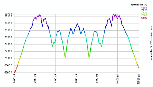
Mt Williamson & Pleasant View Ridge
-
HikeUp

- Posts: 4036
- Joined: Thu Sep 27, 2007 9:21 pm
Nice pictures. Too bad about the other hiker (and the ranger! - at least you saw one  I'm beginning to think they don't exist). As you obviously know, that's one of the issues/difficulties that can come with the territory of "organizing" a hike. Too bad she didn't leave you a note on your windshield.
-
Hikin_Jim

- Posts: 4688
- Joined: Thu Sep 27, 2007 9:04 pm
Joseph:
Cool hike, bro, and, dude, you scored. Clear views like that are not all that common. I just love that kind of stuff -- a long ramble in the high country. Like I say, the stretch of the San Gabs from Three Points to Baden Powell is my favorite.
Bummer about the one hiker. It's always an awkward situation when a group has to split up. I think it's BS that the only way to handle it is to stay with the person. You did some "due diligence" by giving her a walkie talkie. She for sure screwed up by going home without leaving a note.
I guess for next time, you know to tell them to either be there or leave a note.
That ranger was pretty crappy. OK, fine maybe I should have stayed with her. Now enough recriminations; I've got to find this person.
-
JMunaretto
- Posts: 370
- Joined: Thu Feb 07, 2008 11:03 am
Are you advocating illegally entering a trail?!FIGHT ON wrote: Should a done the loop.
-
mattmaxon

- Posts: 1137
- Joined: Mon Mar 24, 2008 12:48 pm
I am interested in how the topo map overlay was done...
Would you care to share?
Was it a simple image overlay? or some other method
Thanks
Matt
Would you care to share?
Was it a simple image overlay? or some other method
Thanks
Matt
-
JMunaretto
- Posts: 370
- Joined: Thu Feb 07, 2008 11:03 am
Yeah Jim, that area is great. I've done the Waterman/Twin Peaks area and PCT from Islip to Baden-Powell so I've seen a good bit of that area and its great. Will definitely be going back to check out some more.

-
Hikin_Jim
- Posts: 4688
- Joined: Thu Sep 27, 2007 9:04 pm
Yeah, I'm curious about that too. That overlay is pretty cool. I hadn't seen that before.mattmaxon wrote:I am interested in how the topo map overlay was done...
Would you care to share?
Was it a simple image overlay? or some other method
Thanks
Matt
-
HikeUp
- Posts: 4036
- Joined: Thu Sep 27, 2007 9:21 pm
-
JMunaretto
- Posts: 370
- Joined: Thu Feb 07, 2008 11:03 am
Yup, I was just messing around with that GPS visualizer site and found it. There's different options, but you can download the topo map overlays based on the coordinates in your gps file, and it will open in in gEarth. then of course you can overlay your track on there too. looks like you can add a bunch of different overlays, then adjust their opacity as well to get the image you want. pretty freaking cool
-
FIGHT ON
NO, you dork! you don't go up the Rattlesnake trail. Go up to Buckhorn and back the ach! And if you had done it then you would have seen that girl on the road!JMunaretto wrote:Are you advocating illegally entering a trail?!FIGHT ON wrote: Should a done the loop.
PS. (that was no ranger, it was me wearing stuff to look like one! I totally thought you were on to me when I kept bugging you.)
-
KathyW
- Posts: 212
- Joined: Thu Sep 27, 2007 9:00 pm
That topo map overlay is pretty cool. Great pictures - I need to do some hiking in that area soon.
Every once in a while there will be a hiker that shows up who isn't ready for the planned hike. This happens even when people have been given enough information to know what to expect - that's the tough part about organizing group hikes with people you are not familiar with. At the same time, think of all the great people you would never meet if you didn't organize these hikes.
Every once in a while there will be a hiker that shows up who isn't ready for the planned hike. This happens even when people have been given enough information to know what to expect - that's the tough part about organizing group hikes with people you are not familiar with. At the same time, think of all the great people you would never meet if you didn't organize these hikes.
-
mattmaxon
- Posts: 1137
- Joined: Mon Mar 24, 2008 12:48 pm
One very interesting effect is to adjust the transparency of the overlay....
Nice... The only program that I found that did that was Topofusion
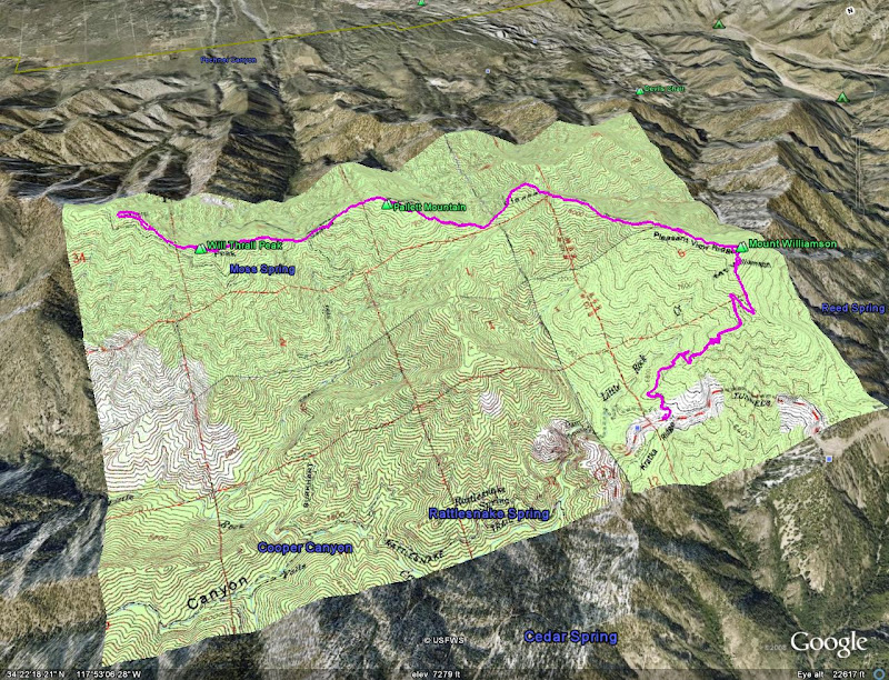
Stone Canyon Trail (the white track is the Stone Cyn trail as shown on the 1939 USGS 6x6min topo)

-
Hikin_Jim
- Posts: 4688
- Joined: Thu Sep 27, 2007 9:04 pm
Nice!
1939 6' x 6'? Where do you get these maps?
1939 6' x 6'? Where do you get these maps?
-
mattmaxon
- Posts: 1137
- Joined: Mon Mar 24, 2008 12:48 pm
http://cricket.csuchico.edu/spcfotos/ma ... earch.html
Once upon a time you where able to download the entire file which I did...
La Cresenta 1939 6x6 USGS topo
One map I have only briefly seen and would like to study in more detail is the 30x15 1900 Tujunga USGS topo
Have not had much luck finding a copy seems rare for some reason
Matt
-
Hikin_Jim
- Posts: 4688
- Joined: Thu Sep 27, 2007 9:04 pm
What type of file is a .sid file? I'm not familiar with that type of file.
I love old maps. I've got a lot of my dad's old 15' War Dept. maps from the 40's and 50's for the Sierra and also local maps. Pretty cool stuff. I probably should donate them to the Huntington or something. They're just in a closet right now.
I love old maps. I've got a lot of my dad's old 15' War Dept. maps from the 40's and 50's for the Sierra and also local maps. Pretty cool stuff. I probably should donate them to the Huntington or something. They're just in a closet right now.
-
mattmaxon
- Posts: 1137
- Joined: Mon Mar 24, 2008 12:48 pm
http://en.wikipedia.org/wiki/MrSIDHikin_Jim wrote:What type of file is a .sid file? I'm not familiar with that type of file.
Expressview Plugin for windows
Can't get enough of that old map stuff! I have a large collection of paper maps (analog) too...Hikin_Jim wrote:I love old maps. I've got a lot of my dad's old 15' War Dept. maps from the 40's and 50's for the Sierra and also local maps. Pretty cool stuff. I probably should donate them to the Huntington or something. They're just in a closet right now.
Matt
-
Hikin_Jim
- Posts: 4688
- Joined: Thu Sep 27, 2007 9:04 pm
Neat old map. Shows all the cabins (houses?) up in Haines Canyon that are just ruins now. So few streets in La Crescenta back in the day, but the general layout of Tujunga is much like today. How cool is that? 
Pretty amazing amount of detail too. 25' contour intervals with 5' supplemental intervals. Wow.
Hey, Matt, thanks. Cool stuff.
By the way, do you know any libraries that might be interested in the old maps that I have? Just getting them scanned would be cool so that they are preserved. Perhaps Chico State where you got your map from, but they're a little far away. The Bancroft Library at Bereley has a bit of a reputation for such things but they too are a bit far away.
I wonder if the Huntington would be interested. Any thoughts? I guess I could just call them.
-
mattmaxon
- Posts: 1137
- Joined: Mon Mar 24, 2008 12:48 pm
I believe that area was known as "Azteca", why it was on the 1939 topo when it was washed away in 1938 is a mystery to me...Hikin_Jim wrote:Neat old map. Shows all the cabins (houses?) up in Haines Canyon that are just ruins now.
It was quite spread out for sure, lots of farming etc.. not a bedroom community as it is now.Hikin_Jim wrote: So few streets in La Crescenta back in the day, but the general layout of Tujunga is much like today. How cool is that?
Can't really say for sure. CSUN has a geography department, the Los Angeles Public Library might need em as well...Hikin_Jim wrote: By the way, do you know any libraries that might be interested in the old maps that I have? Any thoughts? I guess I could just call them.
Sunland Tujunga Historical Society in Bolton Hall might have an interest as well
I'd make a list of the maps available, a 1900 Tujunga would be a gem for sure.
Unfortunately many of these old maps just get tossed out... Any old Forest Service maps or other local maps would certainly be of interest to me.
Cheers
Matt
-
lilbitmo

- Posts: 1092
- Joined: Tue Mar 04, 2008 9:44 pm
Great Pictures, nice TR, have had one very bad experience with ranger three years ago in San G area where the permit was wrong, she initialed it, gave it back to me, chased me down an hour later at 1,000 foot higher elevation, took away the permit, she got very rude with me  and gave me a ticket, which I fought in US Dictrict Court and won the case in Riverside
  . But it's been my experience most of the rangers want to help or are friendly to talk to most of the time.
That being said I did my best to figure out the Mapping Software with Overlays but must be doing it wrong.
Those of you who use that software all the time, can you give me a run down on how to do it right?
I would like to start showing the map of the big hikes I do - like the 9 Peaks hike this past Saturday - would like to be able to give the other hikers insight to it before they attempt it.
Thanks
lilbimo
-
Hikin_Jim
- Posts: 4688
- Joined: Thu Sep 27, 2007 9:04 pm
That's a good idea to inventory what I've got, which I haven't yet done.
I'll have to make some inquiries as to who might be interested in the maps. My only stipulation would be that they need to be digitized and made available to the public. It would be nice to see my dad's collection preserved even if just in electronic form. It would also be a nice tribute to him that his love of hiking lives on to serve others. When I get some time, I'll compile an inventory. I'll post my inventory here first.
I've got USFS maps from 20 years ago, but those probably aren't old enough to be of interest. I also have a lot of 1:50,000 15' military topo maps for the San Gabs, San Berdoos, and San Jacs that I ordered when I was still in the USAR about 20 years ago. Those DMA (Defense Mapping Agency) maps would probably be more of a curiousity than anything really useful unless you just wanted an overview map for planning. For overview maps, I generally just use Tom Harrison's maps although there are a lot of areas he doesn't cover.
HJ
-
mattmaxon
- Posts: 1137
- Joined: Mon Mar 24, 2008 12:48 pm
Well using the default settings on the KML overlay just enter your zipcode in the Location box on the left...lilbitmo wrote: That being said I did my best to figure out the Mapping Software with Overlays but must be doing it wrong.
Those of you who use that software all the time, can you give me a run down on how to do it right?
Then click Create Overlay button on the right
Huh? nothing happens... Wait... eventually you'll get a screen
Your KML overlay parameters have been processed.
Click on the green "Click here to download your overlay" I'd just open the file with GE but you can save it to your PC
Click here to download your overlay
Of course this all assumes you have Google Earth installed and running on your computer
Matt
-
lilbitmo
- Posts: 1092
- Joined: Tue Mar 04, 2008 9:44 pm
Thanks Matt, I play till I get it right.
lilbitmo
lilbitmo