
Mt Baden-Powell the easy way, 7 Sep 2008
-
simonov

- Posts: 1108
- Joined: Tue Nov 27, 2007 5:44 pm
- Location: Reno, NV
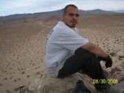
On Saturday my buddy Frank called to see if I wanted to go up Baden-Powell with him and his daughter the next day, and though they were going to start a lot later than I preferred, I said sure. I had failed to schedule a hike of my own this weekend.
When we got to the end of Highway 2, it was sunny, but soon clouds began to form over Mt Baldy and these provided welcome shade during the most exposed parts of the hike.
Thanks to those clouds, it was a very nearly perfect late summer hiking day. A slight breeze would have made it perfect.
There were very few cars in the parking lot when we got there, which surprised me, and most of them probably belonged to the members of a USC athletic team or fraternity we met coming down as we were going up. Where was everyone during this fantastic day in the mountains? On Baldy?
We started at 8:45 and arrived at the summit at about 11:00am. There was no one up there with me when I got there. Soon, about four or six other folks arrived. We spent a few minutes talking to this lady hiker with a foreign accent who says she climbs Baldy every two weeks:
I don't recall seeing her before, but I expect I will see her again in the future.
After fooling around on the summit for about an hour, we got back down to the trailhead a little after 2:00, where we say a handful of people preparing to start their hikes. WTF?
There are these huge bridge supports down there being prepared to be installed on the washed-out parts of Highway 2. I can't believe, with California teetering at edge of bankruptcy, that we are engaging in this massive project to reopen a highway no one really misses. Well, I guess it's all too easy to believe.
More photos.
Nunc est bibendum
-
Hikin_Jim

- Posts: 4688
- Joined: Thu Sep 27, 2007 9:04 pm
Nice pix. Looks really cool w/ those clouds.
Yeah, it is hard to see re-opening ACH (2) when the state's got some serious financial doo doo to wade through. However, for the record, I miss the ACH section that is closed.
If the ACH were reopened:
-Cars parked at Islip Saddle might not be such sitting ducks since all the cars wouldn't be forced to park there (they could be spread out further down the road).
-The service road to Little Jimmy which is a nice alternative to the trail from Islip Saddle and is great for a quick run up Mt. Islip would be accessible.
-The trail from Dawson Saddle to Throop Pk would be accessible. This is a nice, relatively easy hike to a 9'er (9000+ peak).
-For people doing sections of the Silver Mocassin Trail, a car shuttle becomes much easier since one can drive directly back to the starting trailhead instead of going down to Wrightwood, then to Cajon Jct then driving to the start of the ACH in La Cañada, and then driving all the way back up the ACH.
Just some thoughts.
-
HikeUp

- Posts: 4070
- Joined: Thu Sep 27, 2007 9:21 pm
Yes, very nice pics. Thanks for the TR.
A couple more thoughts on re-opening that stretch of the 2...
- it's another escape route for residents of Wrightwood during emergencies (fire, earthquake); not the largest of constituencies, but it is a benefit!
- the monies for the project were probably approved long before the current budget fluster cluck; don't know if they can easily yank funding that is already allocated or after a contract is awarded (bureaucratic swamp).
- last and most certainly least...I want it to be re-opened!
Question regarding the picture of the "green" hillside. Is that really copper ore or is it an attempt to stabilize the hillside above the new bridge they are building? Not sure where that is located but I don't recall ever having seen the green hillside before.
-
Hikin_Jim
- Posts: 4688
- Joined: Thu Sep 27, 2007 9:04 pm
A couple of addenda:
Vincent Gulch is kind of interesting. If you head that way, you can visit the remains of the Big Horn Mine which is a short, very easy hike on a dirt road. Vincent's old cabin makes an interesting side trip. Near the cabin, there's an old mining road that is fairly easy to follow (although quite over grown). I've never been all the way to the end, but surely there must have been another shaft. Why else would they take the time and go to the expense of building a road?
Past the cabin area, you can descend into Vincent Gulch which is a shady, generally well watered area. The creek in the upper end of Vincent Gulch is usually dry, but as you descend, it will start running. There is a very reliable side stream about 3/5ths of the way down as well.
Vincent Gulch flows into the N Fork of the San Gabriel River. From the confluence, you can a) return the way you came, b) stay at Mine Gulch Camp (unmaintained) which is a large flat area immediately west of the mouth of Vincent Gulch, c) ascend Mine Gluch (really tough) which is perhaps 50 yards east of Mine Gulch Camp going to either the main mine shaft or perhaps even the summit of B-P, d) go east up Prairie Fork to Lupine and where the road comes down from Blue Ridge (interesting shuttle hike to be had here) e) descend the San Gabriel River to the Bridge to Nowhere and Heaton Flats (big car shuttle). One normally takes two days to do this. There are camp sites at Fish Fork, Iron Fork, and The Narrows.
I've always wanted to do "e," but I haven't ever gotten around to it. Might be a nice fall hike...
Lastly, for you trivia buffs out there, I believe the Wally Waldron Tree is a Limber Pine not a Lodgepole. Hikin' Jim says "check it out."
-
Taco

- Snownado survivor
- Posts: 6193
- Joined: Thu Sep 27, 2007 4:35 pm
Yup, Wally is a Limber Pine.
I hope ACH2 is opened.
I hope ACH2 is opened.
-
AlanK

- Posts: 1069
- Joined: Thu Sep 27, 2007 9:28 pm
I will also be happy when Rte. 2 is open again.
-
Bill

- Posts: 332
- Joined: Thu Jul 24, 2008 6:09 pm
The opening of ACH will be a good thing for access to our beloved mountains, but I must say I have mixed feelings about it. 
Although 99 percent are responsible with regard to the outdoors, there are the 1 percent that that don't seem to care about or respect it, or others personal property for that matter. (as documented by previous posts) Just keeping it real!
Wrightwood resident
Although 99 percent are responsible with regard to the outdoors, there are the 1 percent that that don't seem to care about or respect it, or others personal property for that matter. (as documented by previous posts) Just keeping it real!
Wrightwood resident
-
brian90620
- Posts: 123
- Joined: Sun Jan 27, 2008 8:34 pm
I really hope it opens up soon , I've never had the chance to take it from La Canada all the way to Wrightwood. It's always been closed since I started going up there.
-
simonov
- Posts: 1108
- Joined: Tue Nov 27, 2007 5:44 pm
- Location: Reno, NV
There are a lot of desirable things I'd like to see or have, but generally only if they can be afforded. This attitude has kept me out of debt for my entire life.
Nunc est bibendum
-
JMunaretto
- Posts: 370
- Joined: Thu Feb 07, 2008 11:03 am
how many hikes are missed just from the closed section of the 2? Getting to the other side of the closed section doesn't seem like a big deal if you are coming from the La Canada end, you could just drive around 210-15 etc in about the same amount of time...
-
AlanK
- Posts: 1069
- Joined: Thu Sep 27, 2007 9:28 pm
I wouldn't argue that it's a big deal, although it is quicker for me to drive the 2 (assuming it's openJMunaretto wrote:how many hikes are missed just from the closed section of the 2? Getting to the other side of the closed section doesn't seem like a big deal if you are coming from the La Canada end, you could just drive around 210-15 etc in about the same amount of time...
-
mtnfox
- Posts: 30
- Joined: Thu Jun 19, 2008 8:54 am
I'm coming out of lurker status for this.JMunaretto wrote:how many hikes are missed just from the closed section of the 2? Getting to the other side of the closed section doesn't seem like a big deal if you are coming from the La Canada end, you could just drive around 210-15 etc in about the same amount of time...
For those of us that live near the eastern end of Hwy 2, it is a big deal. When the highway is open, I can get to Islip Saddle in about 40 mins from my house. With the highway closed, the drive around easily takes 2 to 2 & 1/2 hours. That makes a half day trip a full day trip. I grew up in Wrightwood and although it has been nice to ride or hike out onto the closed portion and encounter some solitude, it will be nice to have easier access to this area for some of my favorite shorter dayhikes (Throop, Little Jimmy) and the occasional drive out to Newcomb's for a burger and a beer (because of the closure I haven't really even been out that way - is Newcomb's even still open?) Having Hwy 2 as an emergency route is also a hot topic among the Wrightwood community.
The target date for the opening is October 14, although the contractor recently said that may not happen. I bet it won't be too much later than that, though, because they get fined $4000 every day after that.
-
HikeUp
- Posts: 4070
- Joined: Thu Sep 27, 2007 9:21 pm
It opens up a lot of point to point hikes and easier car shuttles (depending perhaps on where you are coming from).

Yup.mtnfox wrote:...is Newcomb's even still open?
October - sweet! Thanks for the info, lurker!mtnfox wrote:The target date for the opening is October 14, although the contractor recently said that may not happen. I bet it won't be too much later than that, though, because they get fined $4000 every day after that.
-
406

- Posts: 325
- Joined: Thu Jan 17, 2008 10:36 am
Never had a home or car loan?simonov wrote:There are a lot of desirable things I'd like to see or have, but generally only if they can be afforded. This attitude has kept me out of debt for my entire life.
I agree that the work on the Highway 2 is a complete waste of money.
Should we take bets on when it will wash out again?
-
AW~

- Posts: 2110
- Joined: Mon Oct 01, 2007 12:00 pm
Isnt it closed during the winter? Nov?
Am I the only one who likes the drive? You get to Islip and the confounded gate(although I like the Hwy39 gate a LOT less).
Was it 2004/2005 that took it out? That took a lot of other parts out too. How many times has Chantry Flats been fixed? If it takes one landslide, why build/repair anything?
Am I the only one who likes the drive? You get to Islip and the confounded gate(although I like the Hwy39 gate a LOT less).
Was it 2004/2005 that took it out? That took a lot of other parts out too. How many times has Chantry Flats been fixed? If it takes one landslide, why build/repair anything?
-
Hikin_Jim
- Posts: 4688
- Joined: Thu Sep 27, 2007 9:04 pm
I've lived here all my life, and that's the first wash out on Hwy 2 of that magnitude that I can recall. 39? That thing was a constant problem, and they abandoned it. The 2? Far more tenable.406 wrote:Should we take bets on when it will wash out again?
-
Taco
- Snownado survivor
- Posts: 6193
- Joined: Thu Sep 27, 2007 4:35 pm
They should open 39 up to Crystal Lake, and build a badass extreme jump so you can get onto 2.
The escape route deal for Wrightwood would be real helpful in winter, with the friggin' ludicrous traffic y'all get due to skiiers and snowboarders and such. I hate getting stuck behind that. Chews up a few hours just sitting in traffic, slowly going back towards the 138...
The escape route deal for Wrightwood would be real helpful in winter, with the friggin' ludicrous traffic y'all get due to skiiers and snowboarders and such. I hate getting stuck behind that. Chews up a few hours just sitting in traffic, slowly going back towards the 138...
-
AlanK
- Posts: 1069
- Joined: Thu Sep 27, 2007 9:28 pm
I guess they should have abandoned the 10 Freeway after the Northridge quake.
-
FIGHT ON
J! Some people just like to complain. It makes them feel compassionate. When it is open, the same people will complain that there is too many people!JMunaretto wrote:how many hikes are missed just from the closed section of the 2? Getting to the other side of the closed section doesn't seem like a big deal if you are coming from the La Canada end, you could just drive around 210-15 etc in about the same amount of time...
-
JMunaretto
- Posts: 370
- Joined: Thu Feb 07, 2008 11:03 am
I totally get why it would be a huge time saver for those going west from Wrightwood, and also that its a much more pleasant drive than taking highways. But allegedly (according to google maps) it's 8 or so minutes quicker than taking higways (at least from downtown).
Either way much better to have open than not!
Either way much better to have open than not!
-
mtnfox
- Posts: 30
- Joined: Thu Jun 19, 2008 8:54 am
Oh, don't even get me started on that topic - a whole other can of worms. I could complain about the people driving up both lanes of the highway, parking in your driveway, snowplaying in your yard, leaving trash everywhere...but I won't, because that type of person probably doesn't frequent a nice message board such as this.TacoDelRio wrote: The escape route deal for Wrightwood would be real helpful in winter, with the friggin' ludicrous traffic y'all get due to skiiers and snowboarders and such. I hate getting stuck behind that. Chews up a few hours just sitting in traffic, slowly going back towards the 138...
-
Taco
- Snownado survivor
- Posts: 6193
- Joined: Thu Sep 27, 2007 4:35 pm
Say what you like! This message board is relaxed... hell damn ass shit.
-
mtnfox
- Posts: 30
- Joined: Thu Jun 19, 2008 8:54 am
Don't know if you misunderstood my comment but I want to clarify it anyway in case it's taken sarcastically - I was serious and that was meant as a compliment to this board and it's members. I haven't posted until recently, but I read every day and love this board. The freaks that invade my hometown every winter (not your everyday hiker, and not every winter fun seeker) obviously don't have ANY respect for mother nature or other people. That is NOT the people on this board, who are a wealth of information and are the ones the community welcomes. What I meant was that I could complain about those things here, but the people that need to hear it are not here. now back on topic. Apologies for my digression.TacoDelRio wrote:Say what you like! This message board is relaxed... hell damn ass shit.
-
FIGHT ON
I'll take this one boys. 8) .... Thank you mtfox.mtnfox wrote:Don't know if you misunderstood my comment or what - I was serious and that was meant as a compliment to this board and it's members. I haven't posted until recently, but I read every day and love this board. The freaks that invade my hometown every winter (not your everyday hiker, and not every winter fun seeker) obviously don't have ANY respect for mother nature or other people. That is NOT the people on this board, who are a wealth of information and are the ones the community welcomes. What I meant was that I could complain about those things here, but the people that need to hear it are not here. Don't mean to stir up anything - now back on topic. Apologies for my digression.TacoDelRio wrote:Say what you like! This message board is relaxed... hell damn ass shit.
-
Taco
- Snownado survivor
- Posts: 6193
- Joined: Thu Sep 27, 2007 4:35 pm
Nah, I gotcha. I'm just expressing that you should feel 110% comfortable saying what you wish on here. I appreciate that you like the board! I just don't want you to feel that you have to be areful or too discreet about your posting or whatnot.
-
mtnfox
- Posts: 30
- Joined: Thu Jun 19, 2008 8:54 am
Aha, thank you!TacoDelRio wrote:Nah, I gotcha. I'm just expressing that you should feel 110% comfortable saying what you wish on here. I appreciate that you like the board! I just don't want you to feel that you have to be areful or too discreet about your posting or whatnot.