Santa Anita Ridge and Mt Yale

TRs for the San Gabriel Mountains.
Post Reply
User avatar
JMunaretto
Posts: 370
Joined: Thu Feb 07, 2008 11:03 am

Post by JMunaretto »

Pictures

A friend organized a hike starting from Chantry Flats up to the Mt Wilson Toll Road. I actually have never hiked from Chantry Flats, and was pleasantly surprised by the steepness. Basically gained the ridge and didn't stop for 3000 ft gain. Avoided all fire roads on the way up, with some really steep and unstable terrain!

Image

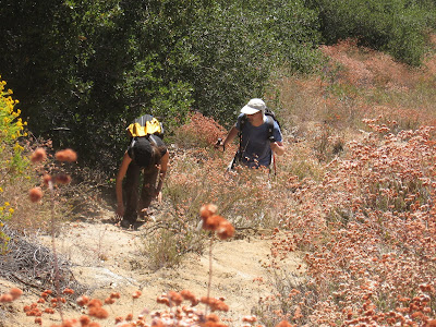
Then, when we got to the toll road, we were gonna wait for the 2nd group to get up there, so I decided to see if I could get up to Mt Yale and some followed. I found some footprints along the east face and continued up to find some faint semblance of trail, though the brush started getting thicker.

We dropped our bags and continued ahead, running into annoying brush but nothing that couldn't be passed. There was one difficult spot where we had to crawl under some manzanita trees (or bushes, I don't know what they're called), which led us immediately to a use trail that we could take to the south. A little more brush long the way, but pretty easily led to Mt Yale.

There are some nice rocks and views from this peak, so I was quite happy to make the side trip. Log book shows not many people visiting it, which is quite rare with a peak around so many popular trails.

On the way back, took the Winter Creek trail which afforded nice shade and a pleasant stroll.
FIGHT ON

Post by FIGHT ON »

JMunaretto wrote:Pictures
What is the picture of the foot for? You makin fun of my sprained ankle? :lol:
Is that an Eagle Rock Eagles Shirt?
User avatar
Terry Morse
Posts: 126
Joined: Mon Mar 03, 2008 8:55 pm

Post by Terry Morse »

Good pictures. I made a similar trip last March, but it was very cold & we were all bundled up.
Two questions:
1-Were the flies/gnats very bad?
2-What were you eating that was in the bowl with a large piece of bread/roll on top. I assume you were at the pack station eating?
User avatar
HikeUp
Posts: 3861
Joined: Thu Sep 27, 2007 9:21 pm

Post by HikeUp »

Cool pictures. Must have been hot - good stuff.

They're eating shepherd's pie at the delirium in sierra madre.

Joe, can you clarify what route you took from chantry to the toll road? Was it the Winter Creek trail (which I didn't think involved steep unstable terrain - should have been all typical trail stuff) ? The bench you are sitting on is at Manzanita Ridge, just below the toll road and Mt. Harvard. Did you get to Mt. Yale from the north? Thanks.
User avatar
JMunaretto
Posts: 370
Joined: Thu Feb 07, 2008 11:03 am

Post by JMunaretto »

FIGHT ON wrote:
JMunaretto wrote:Pictures
What is the picture of the foot for? You makin fun of my sprained ankle? :lol:
Is that an Eagle Rock Eagles Shirt?
Just to show all the dirt.

No idea on the Eagles shirt.
User avatar
JMunaretto
Posts: 370
Joined: Thu Feb 07, 2008 11:03 am

Post by JMunaretto »

Terry Morse wrote:Good pictures. I made a similar trip last March, but it was very cold & we were all bundled up.
Two questions:
1-Were the flies/gnats very bad?
2-What were you eating that was in the bowl with a large piece of bread/roll on top. I assume you were at the pack station eating?
Flies not too bad, but a lot of ants biting and stinging me though.

Chicken & Vegetable Pie at Lucky Baldwins. It was quite good. And I had this beer "Delirium" that was quite tasty.
User avatar
JMunaretto
Posts: 370
Joined: Thu Feb 07, 2008 11:03 am

Post by JMunaretto »

HikeUp wrote:Cool pictures. Must have been hot - good stuff.

They're eating shepherd's pie at the delirium in sierra madre.

Joe, can you clarify what route you took from chantry to the toll road? Was it the Winter Creek trail (which I didn't think involved steep unstable terrain - should have been all typical trail stuff) ? The bench you are sitting on is at Manzanita Ridge, just below the toll road and Mt. Harvard. Did you get to Mt. Yale from the north? Thanks.

http://johndquan.com/images/santaanitaridge.jpg

http://www.mapmyhike.com/walk/united-st ... /323902923

Except I a direct route instead of miles 1 and 2 along another ridge, so it was pretty much all ridge.

Yes from the toll road, we ascended to a use trail along the ridge between Yale and Harvard, then went south to Yale. I had some friends who previously attempted to get to Yale from the south and ended doing some serious bushwacking and rock climbing but also got there. I think they started right where the use trail from Hastings Peak intersects the toll road.
User avatar
HikeUp
Posts: 3861
Joined: Thu Sep 27, 2007 9:21 pm

Post by HikeUp »

JMunaretto wrote:Except I a direct route instead of miles 1 and 2 along another ridge, so it was pretty much all ridge.
Thanks Joe, that route out of Chantry looks pretty tough, especially on a hot day. The winter creek trail is mostly in the shade :D.
JMunaretto wrote:Yes from the toll road, we ascended to a use trail along the ridge between Yale and Harvard, then went south to Yale. I had some friends who previously attempted to get to Yale from the south and ended doing some serious bushwacking and rock climbing but also got there. I think they started right where the use trail from Hastings Peak intersects the toll road.
Nice. I went up to Yale from the south, crawling through a hole in the brush about 50' north of the trail from Hastings. Other than that one spot, it was no problem getting around the brush and rocks - kind of fun actually. Of course I did it when there was about a foot of snow covering everything, which might have made it easier. Here's a pic looking up the south ridge of Yale (Harvard on the left)...
Image

Thanks for the TR - good stuff.
Post Reply