
I and my hiking buddy Kurt enjoy hiking projects that involve long routes split into sections, which we do with two cars. We usually start at 3 AM or so, leave one car at the end of the route, drive to the start and do our hike, then collect the other car and drive home. Some days include urban or suburban walks, which we find more pleasant in the early AM when things are quiet. We did a very long circumnavigation of the San Gabriels that way, the Backbone Trail twice (once in each direction), and a lot of other one way hikes. Most people think we’re nuts but we love these hikes.
Our current project is sort of semi-circle from Kurt’s house in Glendale to Puerco Beach in Malibu. We crossed the Verdugos, then went over Mt. Lukens to big TJ, across the hills to little TJ, up to Bear Divide, and have since walked to Newhall and the areas north of Granada Hills. The first 4 or 5 segments were mostly on well trodden paths that weren’t especially novel, but the last few have been little more interesting so I thought I’d break my long silence here and do a write up. This TR begins at Gold Canyon and ends at Chatsworth Trails Park.
There’s no great way to hike from Gold Canyon to upper little TJ so we cycled that part one weekday evening. Driving up to the Bear Divide/Santa Clara Truck Trail summit to park car #2, Kurt (who isn’t a big cyclist) became a bit distressed by what felt like a lot of distance and climbing. But in the end he conceded that it wasn’t a very hard ride, and as a bonus, the road is closed for repairs right at the summit so there was hardly any traffic and we had little TJ nearly all to ourselves. Nice.
Three Sundays ago we returned to that summit and walked to Newhall — a good day! Heading west from the parking lot at the picnic area there are a few route options - the fire road, a firebreak and the Bear Divide Trail. We chose the latter of course, which led us to the big fire station and the Nike Missile site, which is interesting and has really amazing views. Passing through the fire station, which is a pretty big facility, there’s a big old resident dog that apparently barks loudly at all newcomers, but the staff guys told us not to worry. The “missile site” is a bit of a misnomer because warheads were actually launched from some other nearby location (where exactly, does anyone know?) but the leftover structures and hardware are impressive. We had an early lunch, seated on an old concrete foundation with great views of the Santa Clarita Valley, Newhall Pass, and San Fernando Valley.
Continuing west from the missile site you have to follow the fire road for a while but further on a fire break-ish trail splits left for May Peak. I went that way while Kurt took the low road. The “Peak” is a fairly unremarkable rounded hilltop but it offered more good views. I met Kurt back on the fire road and we walked the rest of the way down to Whitney Canyon Park and Newhall Ave., where car #2 awaited.
The next week we continued on, meeting on Hollywood Way at 0315 (gulp!), so we could park car #2 in Granada Hills and walk across Newhall before the town awoke. From town we passed through the gated little stretch of Calgrove that cuts across a small hill, walked under Interstate 5, and then followed the Old Road (which must have been a new road at some point) to the start of East Canyon trail. A mile or so from the gate, the trail seems to parallel a fault line for a while — maybe the Santa Susana fault? Does anyone know?
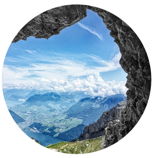
That trail widens and narrows a few times as it climbs through the hills to a summit called Mission Point. Wow, I’d never heard of that spot before but it’s just fantastic, with jaw dropping 360 degree views. It was a wonderful surprise and I’ll keep it in mind next time we get one of those crystal clear days. Making it better for me, there was a group of about 25 hikers up there from, of all places, Nepal. I trekked there a lot on the 80’s and 90’s and was there last November, so it was exciting to hear the language spoken all around me (I still remember some), and exchange namastes. From the peak you can zigzag down to the trailhead at Neon Way, or just head straight down the steep hill. Fun day.
Last Sunday we continued from Neon Way to Chatsworth Trails Park. I didn’t expect that segment to be very remarkable and wasn’t planning to include it in this write up, but it turned out to be plenty interesting, and one of the weirdest hikes I’ve done in a while.
Most of this walk followed the northern edge of Porter Ranch. I’d never given much thought to that place before, but it was strange and surprising. Heading west on Sesnon we passed an as yet undeveloped tract beyond Dali Drive and then the mightily impressive Aliso Canyon, where Sesnon abruptly ends. Apparently there were plans to build a big bridge, which never came to fruition. But there’s a trail that drops southward down to the canyon, heads up the floor of the canyon, and then climbs up to the place where Session continues. Surprisingly to us, that trail was quite indistinct, so I don’t think many people walk it.
From the west side of Aliso canyon the only reasonable way forward is a hiking path that skirts the northern edge of the developments and gated communities that are Porter Ranch. That area is huge, it just goes on for miles. As the sun rose we saw countless large red roofed suburban homes to the left — the number of them and the scale of the place was really startling. To our right were endless rows of private property signs and a few gated roads. I think there are huge storage areas for natural gas up there and understandably, the operators don’t want civilians poking around.
Making the scene feel much like a Twilight Zone episode, the whole time we walked past those developments we only saw one person, and heard no sounds or saw any evidence of life even though we were just feet away from many homes. No cars being driven. no aromas of breakfast, no kids playing, no music playing, no dogs barking…nothing. I can’t imagine living in a huge community with no markets, no cafes, no food trucks, nothing within walking distance. Oh well, I guess that’s me, but it felt really odd, and the trail itself is a bit weird. There are two fences on each side of it, sometimes more. I felt like we were walking through the DMZ or something. I hope I’m not causing any offense with these descriptions but the place felt very unusual to me.
We parted ways with Porter Ranch at Mormon Canyon. Crossing it involved a long V-shaped detour down to the western end of Sesnon where we made a hairpin turn and headed north again. The trail here was very faint and hard to follow. After swinging way back north again we turned left on an even less visible no-name trail through Hidden Creeks Open Space, that eventually connects with Browns Canyon Rd. It was raining by then, and bushwhacking through the high grass and bushes on that trail was plenty difficult. In the middle of all that we passed through what I believe is called HWD Ranch. I have no idea what that place is but it was quite interesting and unexpected. There are 3 or 4 small old wooden buildings, a rusty old tractor, and other artifacts scattered around. We were pretty wet at that point and hoping for a sheltered spot to take a break and eat. HWD Ranch more than came through for us —one building had an old swinging bench, hung from chains and covered by a tin roof. We had a nice respite there, feeling a little like Butch Cassidy and the Sundance Kid in that lonely rustic place.
After lunch we pushed through more brush and undergrowth in the rain, finally emerging at Browns Canyon. From there the road down to the 118 was paved and easy walking. The road is open to the public but strangely, there’s a very short bridge with signs reading “Residents Only.” Well, no one stopped us and it didn’t take long to reach car #2 at Chatsworth Trails Park. (I will add that we enjoyed an awesome lunch at Gus’s BBQ in Porter Ranch, that more than replenished the calories we’d burned.)
The next walks will take us past the so-called Manson family cave, the old Santa Susana Stage Road, Munits Cave, and finally the ocean. I’ll post an update later if people are interested.
Gold Creek to Chatsworth Trails Park, In 4 Segments
-
David Martin
- Posts: 94
- Joined: Sun Nov 08, 2020 7:08 pm
You do not have the required permissions to view the files attached to this post.
-
Elwood

- Posts: 627
- Joined: Fri Aug 15, 2008 5:23 pm
Very nice and informative trip report and hike David. Last time I was up in that area ITT-Gilfillan was operating that facility as an antenna test range of some sort. The magazines and launchers for that LA-94 Nike facility were just south east of you.
You do not have the required permissions to view the files attached to this post.
-
dima

- Posts: 1930
- Joined: Wed Feb 12, 2014 1:35 am
- Location: Los Angeles
I'm not certain how it worked in this area. But in all the Nike sites I know about the launch and operation facilities were in different spots, separated by a mile or so. Could the antenna site have been the operation facility? Cool report, by the way!
-
dima
- Posts: 1930
- Joined: Wed Feb 12, 2014 1:35 am
- Location: Los Angeles
Just read this more closely. Cool trip! I see you mentioned the two Nike sites. OSM actually maps them both. The control site is just W of the fire station and the launch site is just E of it. Did the HWD ranch seem in use? Was there signage?
-
David Martin
- Posts: 94
- Joined: Sun Nov 08, 2020 7:08 pm
HWD Ranch resembled a very small ghost town in the desert, no signage that I recall. I found a couple of brief mentions online and Google shows it on their map but haven't found any real info about it. Curious little place.
BTW I noticed that there's another missile site near Browns Canyon, LA-88. We weren't far from that one but it would've been a detour, and it was a long day for us already, and the weather was unwelcoming. Could be an interesting stop between Browns Canyon and Rocky Peak some other day, though.
BTW I noticed that there's another missile site near Browns Canyon, LA-88. We weren't far from that one but it would've been a detour, and it was a long day for us already, and the weather was unwelcoming. Could be an interesting stop between Browns Canyon and Rocky Peak some other day, though.
-
Nate U

- Posts: 679
- Joined: Wed Apr 05, 2023 7:38 pm
Super cool concept for a hiking project! I like the blend of urban/suburban/mountains.
You are exploring the interface between the San Fernando Valley and the surround mountains.... I know that interface very well!
Just to nerd out, here are the little adventures I've been on (often with the family) along your route.
My personal favorite area is probably the stretch around East Canyon Trail. To answer your fault question - the photo of the suspected fault looks to be just some recent stream erosion from the big winter storms we've had, but all of the Santa Susanna Mtns there are one big Anticline, with a couple more anticlines and a syncline or two in between. Long story short - nearshore sediments have been buckled spectacularly under compressional forces, breaking into various big ole' tilted slabs. Rad stuff.
You do not have the required permissions to view the files attached to this post.
-
Sean

- Cucamonga
- Posts: 4415
- Joined: Wed Jul 27, 2011 12:32 pm
Usually that means they are about to test a nuclear bomb and you had better find a refrigerator to hide in.David Martin wrote: Mon May 04, 2026 9:28 pmMaking the scene feel much like a Twilight Zone episode, the whole time we walked past those developments we only saw one person, and heard no sounds or saw any evidence of life even though we were just feet away from many homes. No cars being driven. no aromas of breakfast, no kids playing, no music playing, no dogs barking…nothing.
Thanks for the report and photos!
-
David Martin
- Posts: 94
- Joined: Sun Nov 08, 2020 7:08 pm
Wow Nate that all is extremely impressive and what a goldmine of future hiking ideas you've posted. By any chance do you have recordings of some of those tracks? I'm going overseas before long but might like to explore some of those areas after I get back.
Thanks again.
Thanks again.
-
Nate U
- Posts: 679
- Joined: Wed Apr 05, 2023 7:38 pm
Each hike is small, but it adds up when you never do the same route twice!David Martin wrote: Wed May 06, 2026 8:33 pm Wow Nate that all is extremely impressive and what a goldmine of future hiking ideas you've posted. By any chance do you have recordings of some of those tracks? I'm going overseas before long but might like to explore some of those areas after I get back.
Thanks again.
In terms of giving you tracks, considering I have like 300+, it really depends on being specific of what you are looking for in terms of target or experience.