Got up and left by around 0720, heading east some more to El Mirage. I hadn't been to the dry lake in about 20 years and in the meantime they've erected a fence around the whole place. I figured I'd circumnavigate the border and go around the eastern edge. It was hot, sandy, and slow, and I eventually went over the low pass on the western side of the Shadow Mountains. I got real low on water so I decided to go south on a prominent dirt road that goes over what I've labelled as 'El Mirage Pass', which drops down to the eastern side of the lake. I didn't have enough water to do a super long ride around towards the friggin 395 to Adelanto. Of course once I reach the pass there's more fence. Considering my health, I teleported to the other side and took the main drag down and out to the town of El Mirage, where I drank a whole lot and filled my bottles up (a little over a gallon). Took a break there for a bit in the shade, then went south to Phelan for a leathery chicken sandwich and a nice cold frosty frappe. McChickens cost nearly as much as a regular chicken sammich. I used to get a ton of em when they were a buck each but now nearly $4 each? Where's the draw? The dollar menu is dead and with it some of the hopes and dreams of dirtbags.
Up into Wrightwood for more water and several gatorade type drinks before pushing up Acorn Trail to Guffy Camp. I slept alongside a downed tree which I improved with some pieces of wood to keep the wind at bay. It was very windy and Guffy is atop a ridge so you get it all. I looked for a better site for some time and settled on the log spot. Despite the strong winds I was nice and cozy in my little spot.
Next day I got rolling at 0800, descended down into Prairie Fork, and rode up to the stream below Columbine Spring. My filter was not working (again), barely dripping, so I took out my old backup and that one didn't work at all. The Katahdin BeFree filter bottle was great but it rarely works now despite cleaning. I am going to bring tablets to purify the water as a backup to whatever new filter I get. Continued up the ridge to the trail to Fish Fork. The sign burned, but not the post. The fire road/trail is in okay shape for a minute or two, and slowly gets much worse. I stopped where it zigs down to the lower road to connect to Dawson Peak Trail, left the bike, and hiked up to Wild View Peak, which does indeed have a wild view. I didn't see any smart ways to haul the bike down a slope to avoid the longer 'regular' way, so I hiked back and went down from the bike stash spot. The road sucks here, and it sucks beyond, almost all of it, almost all the way to the summit of Dawson. Saving some time here, it sucks. I think in cool weather with pants on and plenty of water plus a machete and loppers etc, it might be a nice hike. Otherwise, there's a fair bit of bushwhacking, lots of Buckthorn all over the goddamn place, and some parts have fallen off and are a small challenge to navigate. It is much harder with a bike, obviously.
Iron NF
The trail falls off in places
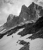
Awesome view
I took a buncha photos of the north side of Baldy, which looked awesome. What a cool place to be. Shame about the Buckthorn. Some parts of the old trail are overgrown with Buckthorn, Manzanita, and other stuff low to the ground, and eventually I got sick of the very demanding bullshit and just pushed straight up the ridge, which is much easier. Pushing a bike up that sorta stuff is like doing a pushup with your feet up on a wall. You stand next to the bike, make sure your feet won't slip in the scree etc, push the bike up, squeeze both brake levers to hold it in place, then take the couple steps up. The surface determines how far you can go with each push, but usually you wanna keep it pretty short. The process for dealing with bushwhacking is much more fun, because it is often painful and feels like you're in a streetfight with blind tweekers in a dumpster full of branches. The brush grabs onto everything, usually preferring your bar end extensions, brake levers, and rear derailleur. Thankfully Buckthorn is both strong AND flexible, so it will get into the spokes and make worrying noises as you're trying to push forward while cursing. At some points I got so sick of the buckthorn that I'd lift the bike up and put it atop the bush so I would have more room to avoid shredding my legs. Some of this Buckthorn was a darker, shorter variety, which rarely grows more than a foot and a half tall or so. The normal white stuff would be much worse.
Close up of Baldy and West Baldy’s north face
Summit of Dawson
Summit of Baldy, thirsty boy central. My brain kept telling me to drink water on the way down, and I comically responded to it that I could not.
I got real frustrated several times dealing with the bushwhacking and charged through while telling the plants to fuck off or eat shit or whatever. By then I had plenty of bleeding cuts on my legs and a few on my arms so I wanted to fight. Long story short, once I got to around 9,000ft, all that dropped off significantly. I saw some Limber Pines and knew I was in the happy zone. Baldy was looking close enough to be doable and I knew I'd be on an actual trail soon, so despite carrying a bike on my back or under my arm or pushing it, life would be much much easier. I reached the summit of Dawson at 1840, took a couple photos, and continued down. Sun set at the Baldy Dawson Col, and I pushed a short distance up before putting my bike in backpack mode, which makes it easier but also fucks my lower back up for a week afterwards. I carried to close to the summit in the dark, a 1,200ft climb, and was making good progress. I finished the last of my water as I started backpack mode, so I was trying to ration sweat, hard to really live by when you're doing this sort of thing. Got to the summit at 2100 on the dot, took a photo, and hid in the rock rings while I texted my family to say I'm OK. I then pushed down Devils Backbone to the Baldy Harwood Col where I rode a bit until it became too rocky and I had to push again. In my state at the time I could not safely do REALLY SICK BIKE TRICKS and ride the real skinny parts cause I was wobbly and I could fall and get pretty fucked up in a stupid avoidable way. The usual skinny part people note as being sketchy is in fantastic shape and was easy. Kept pushing until the 'start' of DBB, where I put my quick release pedals back on for the last time. Rode the brakes down the hill to the notch enjoying not moving nor stomping on the big blister on my right foot that popped hours earlier. The road down from the notch is incredibly smooth! Never seen it in such nice condition. I was taking it easy so I didn't make a dumb mistake but I was still moving pretty fast. I filled up a bottle at the falls, drank that, then refilled it and bombed down Baldy Road. Ended up eating at Raising Canes in Azuser where I probably looked straight homeless. Legs were black with dirt and blood mixed with sunscreen, big cuts all over em, my shirt was very dirty, and I was tired, though not that bad. I did my best to speak clearly and seem like a normal guy who is just real dirty so the kid working the register wouldn't think I was on meth or gonna stab someone or something. I've had to deal with and occasionally fight tweekers when I worked food service so I just want these poor dang kids to have a friggin break, gnawmean? Everyone should have to deal with it occasionally so they don't end up in lala land, disconnected from reality, but also most of the time I just think people should be understanding of people working jobs like that where they get paid shit and no benefits and people are often entitled and rude. Anyway, I drank a SHITLOAD of sweet tea, ate a fairly large meal, headed home, showered, washed my legs three times, put lotion on em (incredible for a straight white guy HEY DON'T SAY THAT), and slept.
My takeaways from this trip are that the Dawson Peak Trail sucks. If a team put a LOT of work into it and somehow people used it often enough to justify the work, it would be very nice, very pretty, and an excellent route for a backpacking trip of 2-3 days. The other end leaving via Prairie Fork would also need a LOT of work so there's more reason for the trail to exist, since it wouldn't be an out and back. The road down into there isn't open nearly often enough to justify that unfortunately. Also, now that the whole place burned, I gotta say it's nowhere near as beautiful as it was, just putting it simply here. Yeah it's still a cool place but man, so much got destroyed that really not that many people would wanna go way out there. I think that's enough about the trail.
I should bring Aquamira tabs as a backup water purification thing. Maybe also a handkerchief sorta thing to filter water into a bottle to keep the big chunks out, then put the tab or tabs in, etc. Having my damn filter suck again wasn't surprising but still had the obvious consequence of me running out of water. I cleaned the filter the week before the trip with a small amount of bleach, and the flow after cleaning and filling it up with water from a sink was perfect. Then, it barely dribbled out when in the field. My backup is one of the PCT'er ones you screw onto a Life Water bottle (I used a Japanese bladder instead). The name escapes me... it was reliable but I hadn't used it much in a couple years so I assume that's why it wasn't working even in the slightest. No loss, they're cheap. I'm sure I'll have my filter game sorted out just in time for the temps to drop and for it to become much less of an issue.
The bike performed without issue. The buckthorn did puncture the sidewalls of the front tire in two places, however, which I plugged with my Dynaplug tool.
I'm running out of Transgabriel routes to do. These start on the north side coming from the train station in Palmdale, and cross the SG's north to south. I've done a lot of the obvious ones (or all?), so if you have an idea holler it out in the reply thingy. Might go back via Lytle Creek and up Baldy Notch, which I've done most of but why not?
Arright, thanks guys. I have a buncha other pics I can share showing Mine Gulch on Baden Powell, huge piles of bear shit, other real pretty views, how bad the trail is, etc. I can share em in replies but I think for the main post we may be limited to 10 photos and doing this on my phone is frustrating and challenging so I play it conservatively.
The numbers for those who like those things are 140 miles with 13,500ft of climbing. As with previous Transgabriel trips, I've done rides with that much numbers in em a lot of times previously but that weren't as hard as this.
Ok byeeeee