Jeff, Nate and I have been trying to get together for a Mt. Pickens outing for some time. We had the outing scheduled for early January, but the date kept getting pushed out because of closure orders. When the order was finally (partially) lifted last Friday, it was on.
We initially were talking about a route that maybe went up the Teepee Trail and down Earl Canyon Road, but Nate came up with an alternate loop that had us ascending Beckley Canyon for a spell, climbing out of the canyon eastward about midway up to the Teepee, hitting Hawks and Pickens from the Lueken Road, then dropping back to the cars via the Earl Canyon Road.
We met Sunday morning at the mouth of Beckley Canyon and started out. To my surprise, Beckley is a beautiful little canyon with flowing water. As we went, we walked through stands of oak, sycamore, and maple, and tramped through a fair amount of brambles. But the going was actually fairly easy as there was a continuous, albeit faint in places, use trail all the way up the canyon.
Eventually, we reached "the narrows" where there was a small waterfall that had to be negotiated. There was slippery log and a couple of fixed ropes that aided in the task, and we all made it through without incident other than getting a little wet.
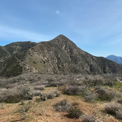
A little past the waterfall, we exited the canyon following the use path upward to the east. The path then climbed (steeply in places) to a ridgeline where we were treated to views of Hawks to the north and the valley to the south. After another short climb we topped out at the Teepee where we stopped for water and obligatory pics of the namesake teepee and views of Strawberry and friends.
From there, we walked to the Lukens Fire Road, ascending it a short distance until we arrived at the toe of Hawks' southern firebreak. Here, we got off the road and followed the red buckwheat to the Hawks' summit. Along with way, I brushed probably 10-20 ticks off of my pants and still ended up bringing on home with me on my side.
From the summit of Hawks, we continued along the ridge northwest toward Pickens, avoiding backtracking to the road. I brought loppers expecting a brush battle, but never used them. When the ridge finally petered out, we rejoined the road and continued to the intersection with the Earl Canyon Road at the foot of the southeaster flank of Pickens. Here, we followed the old firebreak up to the summit, passing a false summit before arriving at the real one. Along the way, and as DavidR has previously mentioned, we had to dodge an infestation of spikey yucca. The climb to Pickens was kind of a slog.
The summit of Pickens was underwhelming. It is covered in brush and lacking in views. I don't need to go there again. We found an open area on the north side of the summit proper and plopped down in the shade for lunch before heading out again. To avoid having to retrace our steps back through all the yucca, we dropped off the north side of Pickens because that was the shortest distance back to the road. That ended up being a bit of an adventure as we got our brush bashing in for the day. I brought home some battle scars from that chunk of the day as well.
Back on the road, we retreated back to the Earl Canyon Road and then made the road walk back to the start by way of the world's longest dirt road.
Stats for the day on my app are 8.5 miles and 2,582 feet of elevation.
Here's the route. I'll post the rest of the pics after i get back from walking the dog. Ha, ha.
Beckley Canyon Exploratory with Hawks/Pickens Sidecar
That looks beautiful! Love that one plant that always grows by creeks, like the one that's in the waterfall pic taken from above. Anyone have the id?
stoke is high
Thanks for the report.
Invasive eupatory. We've been trying to eradicate it from Rubio Canyon.Matthew wrote: Tue Feb 04, 2025 7:43 amLove that one plant that always grows by creeks, like the one that's in the waterfall pic taken from above. Anyone have the id?
Mt Lukens is kind of epic - I've done a full 2 days of hiking on it without even crossing paths with myself, and could probably do at least another 2 full days without hiking the same trail twice.
I joined Uncle Rico on this one to bag Pickens, and we got Hawks bagged and explored Beckley Canyon as a bonus.
Beckley Canyon was probably the highlight, with a strong flow of water (perhaps the best on all of Mt Lukens) and delightful San Gabe front range canyon scenery. Beckley Helped fill the Eaton Canyon hole in me a little bit! The only record on the forum of hiking Beckley Canyon is mattmaxon canyoneered down it in 2011. (it wasn't a rave review) viewtopic.php?p=38670&hilit=Beckley#p38670
• The lower canyon had some big epic oaks in it, with the upper sections getting sprinkles of big cone doug-ies.
• The waterfall we climbed up using ropes and a downed tree was an exciting little challenge.
• The route I had planned ended up having a faint use trail of variable condition, which worked out nicely!
• The teepee was the only time we ran into other people on the route.
• Pickens is full o' brush, including Buckthorn.
• Earl Mtnway is really nice for hiking or mtn biking. Narrow like a trail near the top. Wouldn't recommend a gravel bike.
• Uncle Rico and JeffH are super chill, very capable hikers I'm happy to share any trail (or non-trail) with!
Example of Beckley Canyon scenery above the narrowing. Jeff with obligatory mylar balloon. .
.
.
Emerging out of Beckley Canyon and onto a firebreak. These views reminded me a lot of Eaton Canyon.