
I backpacked 100 miles on the Pacific Crest Trail through the San Gabriel Mountains last Fall. I aimed to hike about fifteen miles per day for six of the days. The extra mileage was split between the first and last day. This was required as I had to recruit my wife to help me park my car at the far end and drop me off at the beginning. She had zero interest in spending a night in the McDonalds parking lot next to Interstate 15 and Highway 138. Go figure. An extra night in a tent in exchange for a ride from San Diego sounded like a good deal to me.
Day 1: I-15 to Swarthout Canyon Road
It was October, but there was a heat wave going on, and the temp was well above 80 that day, down at 3000 feet elevation. We decided to have a late lunch in the air conditioned McDonalds first, to kill some time while the sun declined into the west. Sadly, even though I only had five miles to hike, I had to get moving eventually.

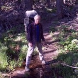
At the PCT trailhead at I-15, near Cajon Pass, where my wife dropped me off - Thanks!

This is the tunnel under I-15 where Crowder Creek flows down into Cajon Canyon, at PCT mile 342

Looking back up the tunnel - I had to hop over the creek when it reached the sand at the end

Looking north toward I-15 and the traffic heading through Cajon Pass

Selfie looking through the corrugated steel tunnel under the train tracks

Freight train headed uphill toward Cajon Pass, with the steel tunnel down below

Freight train making a big turn on its way uphill

Today was the second day of Deer Hunting Season for guns, and I met some hunters along the trail

I decided to deploy my cheap orange poncho, in case someone thought I looked like a deer

Weathered Sandstone formations along the PCT near mile 344 are similar to the Mormon Rocks
Looking southwest toward Riverside and the Cajon Valley in the evening light

The sun was setting over Swarthout Canyon as I climbed up and over the ridge

It was deep dusk so I put on my headlamp to make sure that hunters didn't mistake me for a deer!

Swarthout Canyon PCT Water Cache - it was well stocked thanks to the Trail Angels, even in October

I set up my tent in the dark at the nearby campsite, at PCT mile 347
Day 2: Climbing up Blue Ridge while avoiding Deer Hunters
I woke up in the dark and packed up my gear, then filled my water bottles at the cache. I was starting at 3500 feet elevation, and had about 4000 feet to climb. What with the heat wave, I wanted to get up high into cooler air as soon as possible.

I headed north carrying 40 pounds, ready to make the big climb toward Wrightwood

I crossed Swarthout Canyon Road and climbed over the metal barrier that stops ATVs and motorcycles from damaging the trail

Sunrise color looking southeast down the canyon to I-15, with San Jacinto Peak in the distance

The lush trailside grasses of Spring were brown and gone to seed in the Fall, but they were still pretty

Sunrise light looking north as I hiked uphill, on a typically-easy PCT-style slope

Selfie shot in the first light of the sun - it was still cool, but not for much longer!

Last night's camp was down in that valley, just across the road below that peak (center)

Zoomed-in view looking northeast toward I-15 and Cajon Pass from PCT mile 351

In October 2023, the snow was long-since melted on Mount Baldy (left), Dawson (center), and Pine (right)

I took a break in the shade and switched out my sweaty socks - I usually do this every hour or so

This north-facing slope on the eastern part of Blue Ridge still had a few hardy pine trees

View northeast over Lone Pine Canyon from mile 354

I arrived at a dirt road, Forest Road 3N31YA, near mile 356, not far from Gobbler's Knob

Looking down into the North Fork Lytle Creek Valley from the trail

There were too many trucks and hunters along the road, so I continued north beyond Gobbler's Knob

That's Gobbler's Knob on the right - No, I didn't bother to climb it as it was much too hot that day

I was looking for a campsite, but this one was exposed to both wind and sun, and had flinty gravel - No good!

I hiked two extra miles (13 total) and the spot at PCT mile 360 turned out to be wonderful

My tent and campsite, complete with shade, pine trees, and a fine view
That extra two miles beyond Gobblers also entailed an extra 1000 feet of climbing! Not surprisingly, I was whupped, and it felt great to sit on my air mattress and cook a hot meal. No, I didn't have Grilled Cheese Sandwiches! But I freely admit that I wanted them. I should've called JeffH before I left!
Day 3: Passing above Wrightwood on Blue Ridge
I woke up a bit before dawn and enjoyed a hot bowl of oatmeal. Today looked a lot easier than yesterday, and I wasn't in a rush. I cooked my oatmeal and ate it while watching the lights of cars on the distant freeway and the glow of dawn. I heard one distant bang of a gun down in Lytle Creek and wondered if they got a deer. It was Tuesday, and most of the hunters probably went home two days ago.

The city lights of Riverside glowing below dawn's first color, with San Jacinto Peak above them

After yesterday's long, hot climb, I had less than a liter of water to get five miles to Guffy Spring. I wasn't worried, but I also wished that I'd filled that empty one liter bladder I was carrying at the previous cache. Live and learn. At least I only had 1000 feet left to climb to get there.

I left camp just as the sun began peeking out over the San Bernardino Mountains

Looking southeast down the North Fork of Lytle Creek as I hiked uphill on the ridge

I made it up to the plateau along Blue Ridge near the eastern end of Forest Road 3N06 at PCT mile 362

It felt great to be up in the pines, with cool air and great views southeast toward San Jacinto Peak

I came to the junction with the Acorn Trail, which leads directly down the hill to Wrightwood

The old pumphouse at Guffy Spring, which used to pump water up to a big tank in Guffy Campground

Lovely stream of clean cold water pouring out of a pipe into a tub at Guffy Spring. I filled up all of my bottles this time! I made it there with just a few sips left.

Looking east toward Guffy Camp, as I hiked onward after taking a long break at a picnic table

The trail was cruisey up along the ridge as it ran parallel to the forest roads

Water pond maintained by the Mountain High Ski Resort - both for fires and making snow

Mount Baden-Powell to the west, and Vincent Gap in the cleft on the right, from mile 367

One of the Mountain High Ski Lifts, next to a ski run fittingly called Pacific Crest

Mount Baden Powell in the distance from Highway 2, Angeles Crest Highway, at the Blue Ridge Summit

I knew that there was water at the Grassy Hollow Visitor Center (which was closed) at PCT mile 370

My tent under the pines at the Jackson Flat Group Campground, complete with picnic table - luxury!
There were no groups present, and the camp host lets PCT hikers camp there for free. The water faucet was still running, although the flush toilets were closed. I was happy to have a picnic table to use.
Altogether, I only hiked about twelve miles that day, but I didn't care. I kicked back in my tent and read a book on my kindle, and even took a nap. It was nice to have a lazy day for a change.
Day 4: Bypassing Baden-Powell via the ACH to Little Jimmy
Earlier in 2023, back in March, I started thru-hiking the PCT from the Mexican Border. I intended to hike the entire thing in one shot. But the snows of Winter totally socked in the SoCal mountain ranges, and I wasn't interested (and was too old and risk-averse) to attempt it using crampons and ice axe. The climb up and over Mount Baden-Powell was particularly dangerous. I ended up flipping past all three mountain ranges back in April, hiked to Walker Pass, then came back to do them in May. On the way up to Big Bear, I developed a bad case of Plantar Fasciitis, and I quit hiking the PCT entirely. Sad but true.
However, after Hurricane Hilary dumped all that rain in August, seasonal water sources that normally dry up were renewed. I also had the plantar pain under control by then, so I decided to restart my PCT attempt, with the goal of finishing the ranges I skipped. I decided to do the San Gabriels (PCT Section D) first.
Now, back in the Spring, many of my fellow PCT thru-hikers were skipping Baden-Powell and hiking along the ACH, which was still closed (and remained closed through all of 2023). Even though it was October, I decided that I would join them in spirit, by blatantly cheating and hiking on the still-closed highway. I've been up on B-P several times already, so I wasn't really missing anything. And how often do you get to hike on an empty ACH? It wasn't just cheating; it was also an opportunity!

The night light was on but the building was closed when I woke up at the Jackson Flat Campground

I chose to hike the dirt road rather than the PCT as it was a bit shorter and less steep

Vincent Gap from the PCT at mile 374 - the moment of truth had arrived - to climb or do the road walk?

Since the Angeles Crest Highway had been closed all year, I decided to take this opportunity to hike it

It was quite peaceful on Highway 2, an occasional truck would drive by - we waved to each other

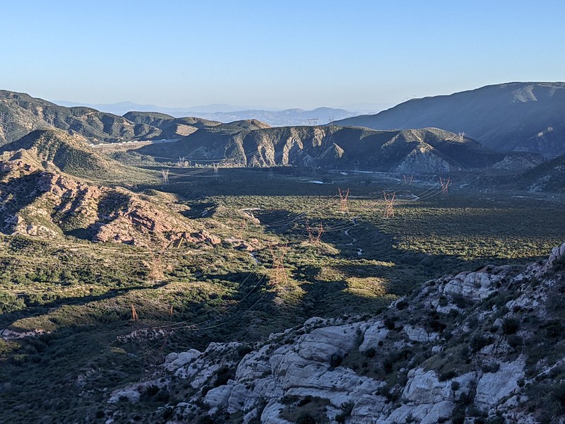
View north over the Mojave Desert - I could see the windfarms on the far side of the Antelope Valley

Three big machines parked on the side of Highway 2, ready for trouble with washouts and landslides

I passed the sign for the Dawson Saddle Trail - I climbed Baden-Powell via this route years ago

New guardrails at the Caltrans garage at Dawson Saddle, the highest point on Angeles Crest Highway

Looking west to Mount Islip (8250 ft) I would be camping at Little Jimmy, near Windy Gap on the left

Caltrans workers unloading big steel girders to help support the washed out roadway, near Windy Gap

Part of the washout can be seen on the left - the girders must be going down there somewhere

My map showed that Little Jimmy Spring and Campground was up that steep wash - No, Thanks!

Big trucks were delivering piles of dirt to this second major washout below Little Jimmy

I decided to climb up Forest Road 3N04 (which services Little Jimmy Campground) to rejoin the PCT

Screenshot from the FarOut PCT App showing my position (blue dot) on the Pine Hollow Access Road
I had to head south (the wrong way) on the PCT for about a mile after climbing up this road.

This area burned a few years back, during the Bobcat Fire, and it was sad to see the dead pines

I arrived at Little Jimmy Campground in the early afternoon - that road walk was fast and enjoyable!

Little Jimmy Spring, a perennial oasis in the Angeles National Forest, located at PCT mile 384

My campsite had a picnic table, and with the highway closed I was the only one at Little Jimmy - so rare!
It was early, so I hung out near the trail. I met several SOBO (southbound) thru-hikers while I waited. They started at the Canadian border back in early July. All in all, there were far fewer SOBOs than NOBOs every year. After hiking over 2200 miles, they had a mere 384 left to go! And they were excited, as it looked like the weather would hold out for the next two weeks. By this point most of them were hiking close to thirty mile days, day after day. They were Hiking Machines. As a "failed" NOBO thru hiker, I had nothing but respect for their efforts.
I got bored eventually (when no one else came by) and went back to camp. I ate my dinner and went to sleep before sunset.
Day 5: Taking the Easy Way Out on the ACH beyond Islip Saddle
Yes, I admit it: I cheated the PCT once again. Partly. I ended up hiking a very long day, at about 17 miles total, and a lot of it was spent hiking on the Angeles Crest Highway rather than the trail. The trail paralleled the highway for much of it, but not all. And there was a LOT of poodle dog bush along the way, which made the highway better.

I woke up early in the dark, and headed north on the PCT out of the Little Jimmy Campground

Highway 2, below, and the Mojave Desert to the north as dawn light began on the PCT near Islip Saddle

Islip Saddle was down below, and I didn't realize that those dark bushes ahead were solid Poodle Dog Bush

Close-up of Poodle Dog Bush flowers and leaves at PCT mile 386 - don't touch them!

The smell of Poodle Dog was strong here - the entire hillside was infested with the poisonous plants

Lonely and deserted Islip Saddle parking lot - there was even more Poodle Dog bush on the far side

View of the twin tunnels near PCT mile 387 on Angeles Crest Highway west of Islip Saddle
WARNING >>> This is Me, singing, listening to my echoes in the tunnel. <<< WARNING

Looking back at the twin tunnels from the western side - I was so glad that the ACH was closed in 2023!

It was pleasant to hike in the shade rather than the hot PCT

I arrived at the Mountain Yellow Legged Frog closure section of the Pacific Crest Trail at mile 390
This is where ALL HIKERS do a three mile road walk to the Buckhorn Campground, where there is an alternate trail leading down to join the PCT in Cooper Canyon.

I took a break and changed my socks on this pleasant boulder near the old Snowcrest Ski Area

At the Buckhorn Campground I stayed on the road as I had hiked the PCT in Cooper Canyon last year

Broken sign for Cloudburst Summit on Angeles Crest Highway, at 7018 feet elevation
I foolishly rejoined the PCT here, and instantly regretted it, as it was rocky and uneven.

The PCT crossed Highway 2 at mile 399 where I met a work crew installing new guardrails

I decided to hike on Highway 2 again as the PCT ran parallel to it for the next four miles - easy walking

There was a small group of private campgrounds off the Highway, but they were all closed in 2023

I stopped for another break at Three Points at mile 403, where the PCT left the highway, heading north

The trail was very cruisey, and the afternoon sun was at a good angle for shade

My tent at the Sulphur Springs Campground at mile 407 - it had been a very very long hiking day
By hiking 16.6 miles (mostly) on the highway, I had effectively hiked 22.8 PCT miles! That's a six mile difference! And I wasn't sad about it either, as I had already hiked this entire section in recent years. I was mostly doing this for fun, and to make up the parts I skipped earlier this year. I planned to hike the 500 mile PCT Sierra Section next year, in 2024, from Walker Pass to Donner Pass, and I wanted all of this SoCal stuff safely behind me in the rear view mirror.
And now I was back on the trail itself, with limited opportunities to cheat by road walking. I vowed to reform myself and become a proper PCT hiker. Tomorrow. Maybe. If I felt like it.
I ate some dinner in camp and checked my mileages. By jumping ahead I had ruined my earlier plans. I stared at the Far Out App (that all PCT hikers use) on my phone. I came up with a new plan soon enough, restoring my preferred fifteen mile hiking days and reasonable water stops. My final day would be shorter by six miles, which was fine by me.
Day 6: Up and Over Pacifico Mountain
Time for another fun day on the trail! My original plan was to camp high on the north ridge of Pacifico Mountain, but the new plan meant that I had to descend to Mill Creek Summit, then climb yet again up to the ridge near Mount Gleason Road. In the roasting hot sun during a heat wave, of course. But that's life.

I woke up early and hiked out, up Sulphur Springs Road, 5N04H, on my way to Pacifico Mountain

The first light of the day didn't take long to hit me near PCT mile 409 - the sweating would begin soon

I reached the shade of pine trees after climbing for hours, but at least the slope was mellow

It felt good to have a plentiful supply of cold clean water direct from Fountainhead Spring
I filled up everything here, thereby carrying a lot of unnecessary weight, because I forgot that there was a faucet at Mill Creek Summit! That's the problem with changed plans: Incidental details often get neglected.

The PCT flattened out near the Pacifico Mountain summit, and it was nothing but cruisey hiking

The trail traversed around the northern side of the mountain near mile 412

Lunch of Champions - a strawberry Pop-Tart - plus a fantasy book on my ultralight Kindle
This was near the intersection with Pacifico Mountain Road. Last time I was here, we took the road down to the bottom, as the weather was horrible. This time I wouldn't cheat.
While eating, I met a deer hunter driving an ATV on the road. He said that he hadn't seen a single deer yet. Nor had anyone else I met this trip. We blamed Hurricane Hilary for dumping all that extra rain and changing the typical Fall vegetation and water supplies.

Looking up toward the summit of Pacifico Mountain (7124 ft) - no, I didn't feel like bagging it that day

I was on the long descent and there were pretty clouds behind me

Later today, I would be camping along that ridgetop (right of center) just beyond the saddle

It was getting hot as I neared Mill Creek Summit, and there were no longer any shade trees

Looking down the hill toward the Mill Creek Fire Station from the day-hiker parking lot where I got water from a faucet

I took a long break in the shade of that tree, as I had a few more miles to go, and all of it was uphill

The trail crossed Angeles Forest Highway at Mill Creek Summit - uphill both ways!

Looking east at Pacifico Mountain from the PCT mile 420 as I huffed and puffed uphill

The PCT followed along Mount Gleason Road, FR 3N17, and I wished that I was down there in the shade

I came to an area with big old oaks that hadn't burned in the Station Fire, and I was happy to see them

I set up camp in the shade at mile 421, with a great view - nice spot!

It had been a long day, and it felt good to sit on my air mattress and cook my dinner just outside the tent
I had great cell signal up there, and I used it to call my wife and send out a few photos. On the way uphill, a couple of pickup trucks drove by on the road, and I figured them to be deer hunters, arriving on a Friday night, hoping to bag a deer come dawn. I decided to get up early (as usual) but also to wear my headlamp longer into the day, in order to remain as un-deer-like as possible.
I also left my tent door wide open (just the screen) so I could enjoy a bit of air and starlight.
Day 7: Mount Gleason to the North Fork Ranger Station

I woke up early to see the lights of Palmdale below me to the north

I was happy that it was a calm morning as I packed up all my gear - only one more night on the trail!

Dawn color in the clouds from the trail near Peak 5671

The PCT was very cruisey on the ridge but the brush was beginning to encroach upon the path

I decided to leave the PCT due to excessive whitethorn and road walk (on FR 4N24) to Mt Gleason Road
Last time I was here we also left the overgrown trail. I was hoping to hike it this time, but why suffer? Yes, my vow not to cheat was broken, but I didn't care.

View south, down the North Fork Mill Creek Canyon, from Mount Gleason Road (3N17.5)

The Station Fire Memorial at Camp 16, where six firefighters died
Seeing this monument is yet another good reason to leave the PCT for the road

I continued on Mount Gleason Road to the spot down below in that saddle where I was able to rejoin the PCT at mile 427
Last time, my wife and I stayed on the main road all the way over the peak. I decided to give the trail yet another try.

Naturally, the trail was still horribly overgrown with nasty whitethorn plants after I rejoined. Sigh...

It was nice to see so many unburnt pines on the northwest side of Mount Gleason that survived the Station Fire

I had reached the highest point of the day on Mt Gleason - it was all downhill toward Messenger Peak

Messenger Peak and Messenger Flats Campground from PCT mile 430 as I descended from Mt Gleason
There were quite a few hunters camped at Messenger Flats, but I didn't meet any on the trail.

Amazingly, there was still water flowing in October at mile 432, but I still had plenty left

I crossed over Santa Clara Divide Road (3N17.5) west of Messenger Peak

The road continues to the left, but the PCT drops down beyond this saddle and saves many miles

After a hot day of hiking it felt good to see my destination at the North Fork Ranger Station, PCT mile 436

The caretaker keeps the Ranger Station in a state of readiness, and provides hikers with water

There is always water here, thanks to Todd the caretaker. He also gave me some cookies and Gatorade!

My tent on the breezy saddle in the old picnic area.
After a relatively easy fifteen mile day, I still went to bed before sunset, as I planned to get up early.
Day 8: Pre-dawn hike to my car in Soledad Canyon
It was my last day of hiking PCT Section D. With the exception of a climb out of a small canyon, it was downhill all the way to the car. I decided to wake up super-early in the dark even though I only had eight miles left to hike. It was a Sunday morning, and I figured that if I hustled to the car I could then blast south on the freeway to San Diego before the LA traffic got up to its usual afternoon weekend gridlock. Plus, I knew that it would be absolutely roasting later on, down in the valley at 2500 feet elevation. No thanks!

I carried that oatmeal a hundred miles, and by God I was going to eat it!

View of the trail, hiking by headlamp before dawn, with tall grasses

The lights of Acton were off in the distance as I continued downhill, at mile 438

The only ascent of my day, out of Mattox Canyon, and I got there before the sun arrived to toast me!

Looking northwest up Soledad Canyon toward Acton from the PCT mile 441

My car was somewhere in the depths of Soledad Canyon - the PCT eventually goes up and over that sunlit ridge toward Vasquez Rocks, but I already did that part in April.

Even though I was in sunlight, I didn't care as it was still cool and I only had two more miles to hike

My car was down in the Indian Canyon Trailhead Parking Lot at PCT mile 444 - I was almost done

Selfie with my car and a week's beard growth. And it was still early morning!
All in all, it was a great week of hiking. The San Gabriels are an interesting mix of chaparral and forest, and have no shortage of elevation gains/losses. Even though I've hiked this PCT section before, I did it in short pieces spread over many years. This was the first time doing it in one week-long blast. Very satisfying.
To the forum members: I apologize if this TR was too large, but you can't say I didn't warn you! It's right in the title. Ha ha! At least I did my best to keep the yakking and walls of text to a minimum, while maximizing photos, which are great for saving reading time. I hope you agree.
For a map of my entire 2023 (failed) thru-hike attempt: https://caltopo.com/m/UFSAT
For LOTS more photos of PCT Section D see my Flickr page at https://www.flickr.com/photos/_jfr_/alb ... 0313819322
If you are retired and/or have a nearly unlimited amount of time you could read all about my PCT thru hike attempt on my very wordy and photo-filled photojournal/blog/website: https://hikingtales.com/pct/pct-2023-thru-hike/ and if you only care about the San Gabes then start at Day 35 and stop at Day 42.
NOTE: This TR is dedicated to HikeUp, who (rightfully!) insists that ALL hikes in the San Gabriel Mountains be duly chronicled on the forum as official Trip Reports. I have to say that I agree with him wholeheartedly.


