
In his 1895 book, History of Pasadena, Hiram Reid describes several peaks of the front range. One of them is called Black Jack Peak, which he locates in front of Strawberry Peak. Indeed, an alternate name for Black Jack, according to him, is Little Strawberry Peak.
Reid further describes Black Jack in his 1905 book, Hand-book of Pasadena.
Now, there is a problem with Reid's descriptions. While viewing the range from Pasadena, he mistook Disappointment for Strawberry. So, it's unclear where Black Jack should be exactly.
Historian John Robinson claimed in 1971 that Black Jack was actually Mt. Lawlor.
(100 Peaks Lookout, January 1971)
How Robinson arrived at this conclusion, I don't know. If he's interpreting Reid, then I disagree with his interpretation. I believe Lawlor is what Reid called Square-Top.
If Square-Top is not Lawlor, then what is it? It's not Mt. Markham, unless Reid listed the same peak twice under two different names, and also botched the location, since Markham is not between San Gabriel and Strawberry. No, I think Reid's description of Square-Top fits the reality of Lawlor, it being a lesser peak between San Gabriel and Strawberry, and also having a peculiarly flat and square-shaped summit. Furthermore, keep in mind that Black Jack was previously called Little Strawberry, and I fail to see a significant resemblance between Lawlor and Strawberry.
I do, however, think that Peak 5521 resembles Strawberry. Here is a view of both from the Colby Canyon Trail.
And this is how they look from the Strawberry Peak Trail.
By the way, here is a topo of the general search area, showing 5521 directly south, or in front, of Strawberry.
5521 closely matches Reid's description for Black Jack. It's essentially a smaller cone in front of Strawberry, simply a spur with a distinct pinnacle. Again, this doesn't seem to match Lawlor, which offers a flat top. It's also odd to think of Lawlor as a mere spur of Strawberry, since it has a respectable prominence and it sits upon the high ridge of the front range. Whereas 5521 truly is a simple spur that drops sharply into Colby Canyon.
Given this information, I needed to visit 5521 myself. Because what the hell (?!), as well as what sort of rock is up there? According to Reid, Black Jack's pinnacle should be composed entirely of a porphyritic rock that miners called "black spar." Despite having a kindergarten-level knowledge of rocks, maybe I could discover further evidence for 5521 being (or not being) Black Jack.
Based on prior scouting of the region, and looking at aerial imagery, I expected there to be a half mile of tough scrambling through tough brush, if I departed the Strawberry Peak Trail at an ideal spot. Thankfully I recruited several friends to join the effort. Nate knows rocks and offered to help identify whatever we found at the peak. Also from the forum, Uncle Rico, Tekewin and Jeff joined the party. And Scoops and Guy are fellow trail workers who generally enjoy hacking and trimming things.
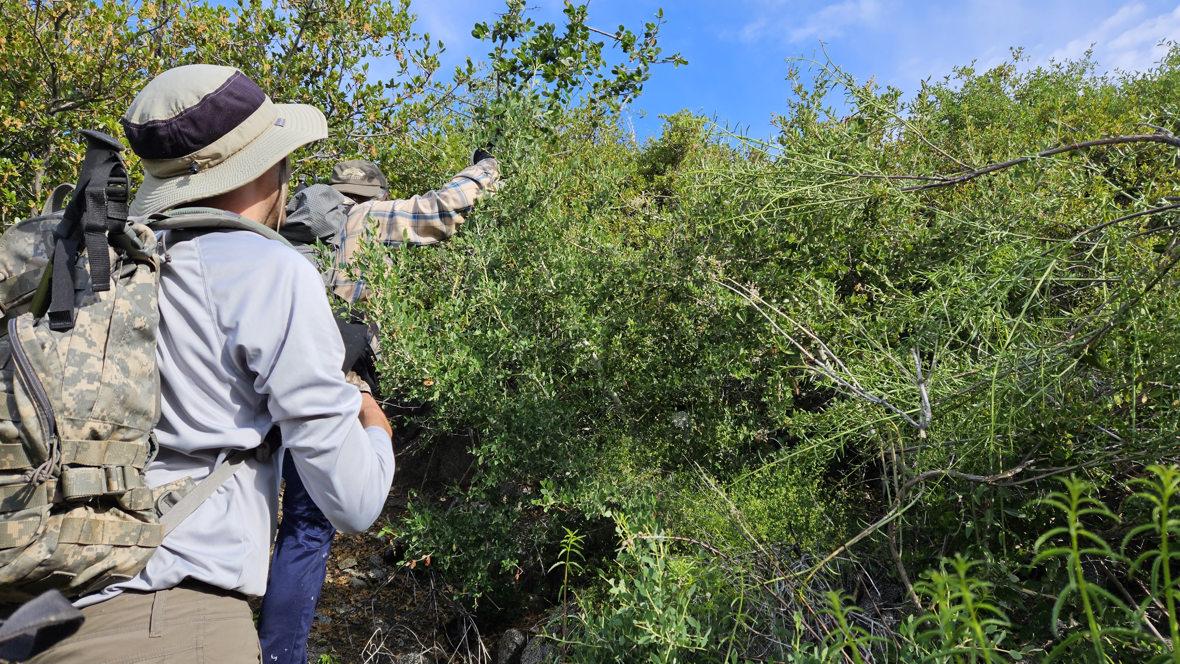
Together, armed with loppers, machetes and clippers, we cut a half-mile route across the south face of Strawberry to summit 5521. We scrambled over a few boulder piles, but mostly trimmed our way through a lot of thorny and scratchy brush. Despite being dressed for battle, we took turns stumbling and getting impaled or scratched through our gloves and clothing.
Eventually we broke through to the spur ridge, and life became easier. The ridge top had a decent animal track, and we could weave our way to the summit without much resistance.
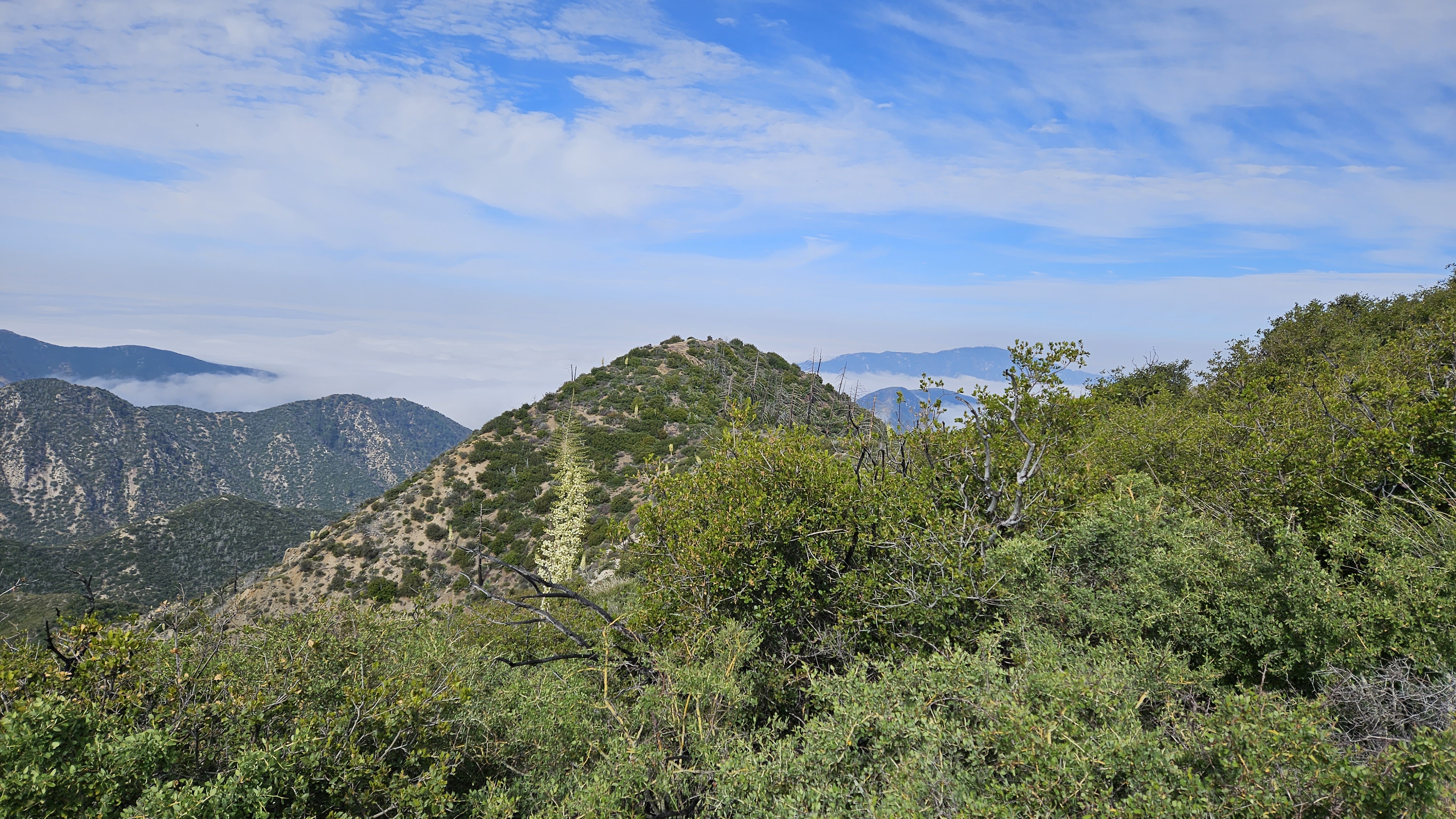
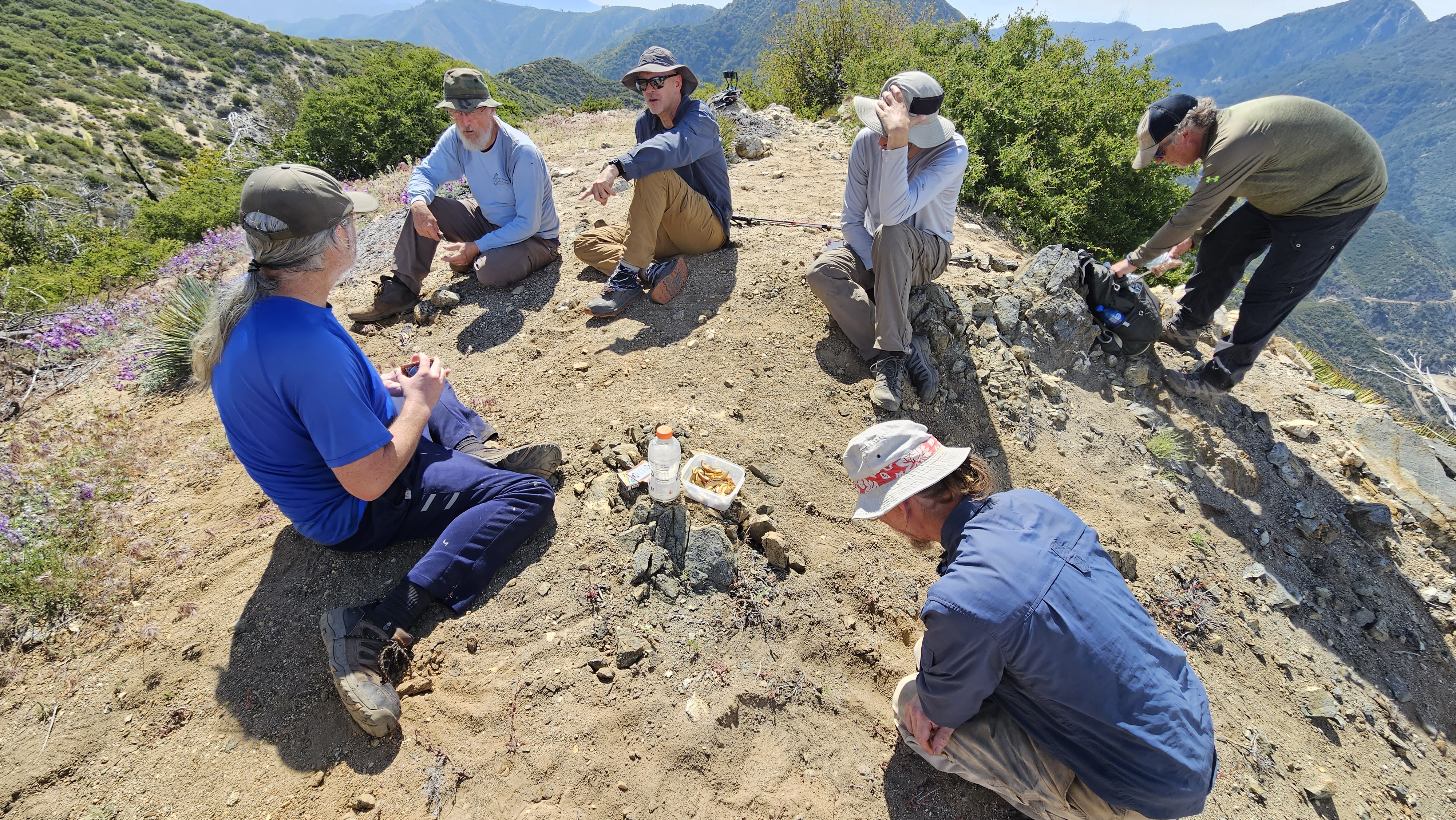
5521 had enough room for everyone to sit and enjoy a snack. It's a relatively narrow peak though, with a small rock outcropping at the top.
The west ridge, however, looked very rocky and difficult as it headed down toward Colby Canyon.
To the north was the grand, rocky face of Strawberry Peak.
Nate said that about a third of the rocks on 5521's summit qualify as porphyritic.
That's not exactly a perfect match with Reid's description. But it didn't prevent us from playing a game of blackjack on the peak and naming it Black Jack anyway. Yeah, we left a register up there, and if you can follow our route, you should have a fairly easy time reaching it--until the brush regrows.
Tekewin's GPX file
The Search for Black Jack Peak
-
Sean

- Cucamonga
- Posts: 4289
- Joined: Wed Jul 27, 2011 12:32 pm
You do not have the required permissions to view the files attached to this post.
-
Uncle Rico

- Posts: 1484
- Joined: Thu Mar 20, 2008 7:48 pm
Good scratchy fun.
Here's a few more pics from the outing. The last one is us playing Black Jack on Black Jack.
Here's a few more pics from the outing. The last one is us playing Black Jack on Black Jack.
You do not have the required permissions to view the files attached to this post.
-
tekewin

- Posts: 1392
- Joined: Thu Apr 11, 2013 5:07 pm
Despite leaving with thorns in both my hands, this was one of my favorite hikes of the year. Great fun exploring a new area and it was nice to finally meet Jeff and Nate from the forum, and Guy and Scoops. The brush was a little worse than the satellite photos suggested, but the team was well armed. Loppers, 2 machetes, and 2 pruners. I just ordered the Fisker loppers you brought for future brush battles.
So close, but so far away
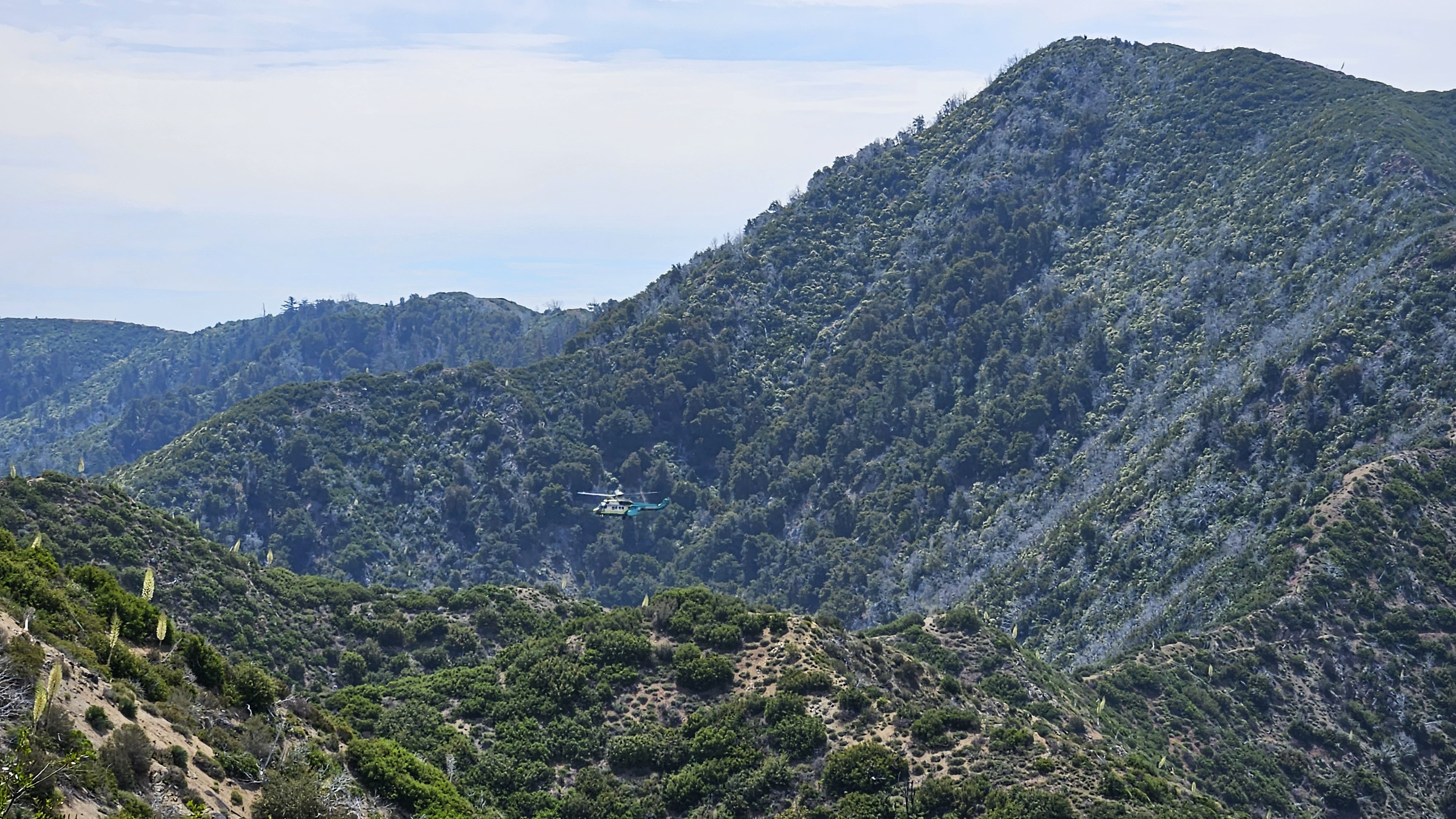
Rescue helicopter at the Strawberry/Lawlor saddle (on the way back)
So close, but so far away
Rescue helicopter at the Strawberry/Lawlor saddle (on the way back)
-
Sean
- Cucamonga
- Posts: 4289
- Joined: Wed Jul 27, 2011 12:32 pm
-
Nate U

- Posts: 626
- Joined: Wed Apr 05, 2023 7:38 pm
• Big thanks to Sean for all the historical research that went into making this not just a neat off-trail hike but also a really fun investigation with a story, and extending the invite to assist in the expedition's geologic identification!
• It was very cool rising above the marine layer to a beautiful sunrise we enjoyed on the way up the Strawberry Peak trail.
• Sean pulled together an impressive group of experienced hikers, guys who know these mountains and their history, and know how to navigate them. I was continually impressed all day long how the walls of Buckthorn we pushed and cut through never phased anyone. Did I mention I found my people with this board?
• This was my first Buckthorn off-trail scramble, and I feel as though I quickly made a close acquaintance with the bush. Pretty unforgiving stuff, probably the best thing it has going for it is a good pair of loppers go through it pretty readily.
• On a related note, I now fully understand Sean's trail-cutting scramble strategy for heavy brush. Its not as fast as the close-your-eyes-and-push/duck/weave/crawl technique I've always employed, but the time you spend lopping on the way out you save with a quick low-stress already-cut path retrace on the way back. It also makes all the more sense if you have a group to help.
• On a still related note, I'm also buying a pair of Sean's Fiskar loppers!
• Emerging from the mess of Buckthorn, Manzanita and Lechiguilla to arrive on that exposed ridge and confront across the canyon the majestic granitic south face of Strawberry was the sort of moment I live for out there. I called back in jubilation to the rest of the crew that we made it, and it was great to see that same feeling come over everyone as they witnessed the sight for themselves. The readers here know what that feeling is like.
• Like Sean mentioned, only the dioritic portions of the exposed ledge on the summit (about a third of the rock?) could be considered matching the "flinty" "black spar" of the description. I had been hoping the summit would be the darker, often flinty metamorphic Mendenhall gneiss, as my USGS map indicated we were on the edge of that formation, but no 5521 was a mix of granitic rock, only a dioritic portion being black. But I feel like its close enough, and as Sean reasons, matching other qualifications, to be the Black Jack Peak of legend. Here I am pointing out some of that black Diorite at the summit:
• The exposed, 360 degree views of the summit made a great spot to play a few hands of blackjack with Sean's pirate deck. And super cool takewin brought their drone for some epic shots.
Upon getting home, I pulled a few lechuguilla frond tips out of my legs with tweezers. Glorious!!!
You do not have the required permissions to view the files attached to this post.

-
craigchanowski22
- Posts: 14
- Joined: Mon Aug 22, 2022 4:09 am
Sean/Keith/Nate & Pals-Great job and nice video-thanks for for sharing and keep up the good work.
-
Sean
- Cucamonga
- Posts: 4289
- Joined: Wed Jul 27, 2011 12:32 pm
Here is Jeff's group shot.
And Guy sent me these additional photos to share.
And Guy sent me these additional photos to share.
You do not have the required permissions to view the files attached to this post.
-
JeffH

- Posts: 1390
- Joined: Sun Nov 28, 2010 7:09 am
Well that was fun. I have approximately 842 cuts and bloody pinpricks on my lower legs from the buckthorn and yucca. I don't have anything to add to what's already been said, it was just another great day in the San Gabes.
Heading toward the sun.
Lots of yucca blooming right now, the early morning light really shows off the flowers.
First good view of Little Strawberry.
Sky islands in the clouds.
It was very helpful to have these cairns on the way back down.
Nate scouting trail when we thought it might be better up on the ridge - instead we took the drainage up.
Starting to look less congested as we got nearer to Black Jack. That of course is a relative term...
The final push. This looks a lot like the photos we see of Everest now.
I want to be like Hiker Girl when I grow up and learn all the plants.
You do not have the required permissions to view the files attached to this post.
"Argue for your limitations and sure enough they're yours".
Donald Shimoda
Donald Shimoda