
Kurt and I have been circumnavigating Angeles Forest, mostly hiking the edges of the range, and now we’re approaching Wrightwood, which has meant long drives. Last weekend we decided to stay closer to home and do something more central. Strawberry intrigued me so I put together some possible routes. After getting feedback from Dima I picked a loop that would take us up from Red Box to Switzer, up Colby Canyon to Strawberry's west ridge, and then back down to Red Box. He said it would be “a little exciting” for us, without really explaining why. I’m glad he didn't, because the fun part in the middle was a cool surprise for us.
At 5 AM we parked at Red Box and set out on the Gabrielino Trail in the dark (really dark!), heading towards Switzer. Towards the bottom of the canyon the sky lightened, revealing bright colors from new wildflower growth. We took a little snack break at Switzer, and several hundred carbs later walked the road to the Colby Canyon trailhead and headed up. Wow, Colby’s really beautiful, and building that trail must have been quite an engineering feat. Looking down-canyon, the big buildings of Glendale were just visible through the smog. Lots of other hikers were on the trail, a rare sight for us on these early morning outings. This trail, and the Gabrielino, were in great shape with almost no fire damage.
At Josephine Saddle most of the hikers and groups headed left, towards Josephine. We took the ridge trail to the right, which was also in good shape, but a little indistinct in places. Before long the gnarled rocky summit of Strawberry came into view. We couldn’t see any trace of trail heading up it, and wondered what that part would be like. It looked pretty steep!
Continuing up, we passed about 6 other hikers who were returning from the summit. One dude, who might’ve been a football player, had about 4 times the muscle of Kurt and me put together. After seeing him we might have doubted our worthiness but his partner was a cute young woman in shorts, which encouraged us. (Though in theory he could have carried her up.)
Near the big boulder that marks the start of the real climb, two guys heading down gave us some good tips. Where the trail up appears to go left, go right instead for a bit (very important), and then straight up. Where “Kamper Ken” is painted on a rock, bear left. Look for faded arrows on the rocks, but choose your own adventure, they said. It’s not as intimidating as it looks from here, they said. (Also, I noticed what appeared to be a trail, angling up the southern side of the peak. Whatever that is, ignore it.)
In the end it wasn’t really that difficult, or confusing. We just took it slow, with lots of short breaks to re-center ourselves and check the next little section. Footprints in the dirt and scuffs on the rock helped point the way, and there were plenty of good handholds. I think it took about 30 minutes to climb the final steep section.
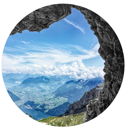
Up top on a clearing just before the peak we passed a group that was settled in on folding chairs, laughing and munching on snacks. It looked like a pool party without the pool. Further up, there were several other groups but luckily, the prime spot at the summit marker was vacant so we claimed it and took lunch there while enjoying the views. And man, those views are amazing, especially to the north.
The trail back to Red Box was in good condition but unremarkable, at least compared to the first part of the hike. Lotsa hikers and dogs.
After hiking these mountains once or twice a week since November, I was surprised by how little snow there is now. Baldy had just a thin coat of white, and that was about it. And it was warm! At 5 when we left Red Box it was 62F, 20 degrees warmer than Vincent Gap had been the previous week, two hours later in the morning. On the Gabrielino Trail we felt warm breezes coming up from the L.A. basin before sunrise, and heading down from the summit towards Red Box on those exposed slopes, it was downright hot. That was the first time I’d felt warm while hiking in about 6 months.
13 miles, 5:19 moving time, 3110 feet of climb. What a great day. Kurt said it could only have been better if we'd carried some strawberry ice cream up there, packed in dry ice. Here's my recording. Below are a few photos, but sadly none showing the rock scramble…guess I was too preoccupied climbing it to think about that. But I might go back with my brother in a few weeks and if so, I’ll make up for that, and maybe bring some ice cream, too.


