
We might have jumped the gun on the opening of Mt. Wilson. Headed up Bailey Canyon from Bailey Wilderness Park. There is a field of Matilija Poppies right at the parking lot.From there climbed steeply towards Jones Peak. Noble Penstemon flowers on the wayNice views of the city from Jones Peak
From there we hiked the Ridgeline to Hastings Peak. The trail was overgrown but not hard to follow
Survey marker on Hastings Peak
From Hastings Peak the trail leads along the ridge then sharply down and nearly straight up 200'. It was not bad, plenty of reasonable foot placements.
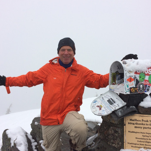
From there along the Mt. Wilson Toll Road to the summit. There is still a lot of poodle dog on the last leg of the hike. We had the summit all to ourselves for a change
The descent was down the Mt. Wilson Trail to the Jones Peak cut-off, up over Jones Peak and back down Bailey Canyon.
16.3 miles 5,500' of gain. This may become my favorite Mt. Wilson route.
Bailey Canyon Jones Peak Hastings Peak Mt Wilson Loop
-
JerryN
- Posts: 200
- Joined: Sun Nov 11, 2012 4:01 pm
You do not have the required permissions to view the files attached to this post.
-
JeffH

- Posts: 1367
- Joined: Sun Nov 28, 2010 7:09 am
That's a good walk, you still had nice weather for it. In the summer it would be brutal, from the Jones Peak saddle to Hastings is all in the sun. I did that route a couple times this winter, stopping once to clear some brush on the lower part of the trail. I haven't gone up to Wilson from there, while standing on Hastings it didn't seem right that the 'trail' was that steep wall so I went down via the main Wilson trail.
"Argue for your limitations and sure enough they're yours".
Donald Shimoda
Donald Shimoda
-
Girl Hiker

- Posts: 1449
- Joined: Fri Apr 04, 2014 7:46 am
-
HikeUp

- Posts: 4042
- Joined: Thu Sep 27, 2007 9:21 pm
The trail from Hastings Peak up to the Mt. Wilson Toll road used to have a nice switch-backed trail built by Hiker Bob. This was back before the Station Fire. Even before the fire, a bunch of asshole switchback cutters had destroyed Bob's excellent trail. Then during the Station Fire the bull dozers completely obliterated it.
Before: ridge trail can be seen climbing up to the obvious toll road cut left of center...
After: bulldozed. they ran the dozer all the way from the toll road to Hastings, to Jones Peak and down bastard ridge to the mt. wilson trail...
Before: ridge trail can be seen climbing up to the obvious toll road cut left of center...
After: bulldozed. they ran the dozer all the way from the toll road to Hastings, to Jones Peak and down bastard ridge to the mt. wilson trail...
You do not have the required permissions to view the files attached to this post.
-
Girl Hiker
- Posts: 1449
- Joined: Fri Apr 04, 2014 7:46 am
-
JeffH
- Posts: 1367
- Joined: Sun Nov 28, 2010 7:09 am
Thanks HikeUp - I had to go back to my pictures from new years day this year to see. I was looking for trail but now I can tell this fire break cut is the route. I didn't know how much downhill was involved in going over that way so I retreated and went down the main Wilson trail and road walked back to Bailey Canyon parking.
(photo from top of Hastings)
(photo from top of Hastings)
You do not have the required permissions to view the files attached to this post.
"Argue for your limitations and sure enough they're yours".
Donald Shimoda
Donald Shimoda
-
JerryN
- Posts: 200
- Joined: Sun Nov 11, 2012 4:01 pm
While it is quite steep, it is a totally doable climb. It is not nearly as exposed as it looks.
-
bcrowell
- Posts: 228
- Joined: Sun Dec 30, 2012 9:51 am
I like going up the main Wilson trail but then cutting up the south-east side of Jones Peak (not the connector, but the route that starts below the dam). There used to be only a minor use trail there, but Charlie Bell has made a little side loop that goes half-way up Jones. Then you can continue up the original use trail to the top of Jones.
Usually wouldn't visit this area at this time of year, though. Too hot.
A couple of other unusual routes up WIlson: (1) The ridge east of Little Santa Anita Canyon. I parked on Camillo Rd, and then I think I had to walk between a couple of houses to access the ridge. (2) The ridge behind the monastery. This has one spot where you have to pass through a steep notch with exposure on both sides. Routefinding is confusing if you come down, better to go up and then come down some other route.
Bailey Canyon is also a super fun and safe canyoneering route, with excellent bolted anchors. Just make sure not to get caught in a rainstorm, because it has flash floods.
Usually wouldn't visit this area at this time of year, though. Too hot.
This last winter it was possible to get through there without touching it. Is that still possible, or is it crowding the trail so much that you can't avoid it? I'm super sensitive to that stuff.JerryN wrote: There is still a lot of poodle dog on the last leg of the hike. We had the summit all to ourselves for a change
A couple of other unusual routes up WIlson: (1) The ridge east of Little Santa Anita Canyon. I parked on Camillo Rd, and then I think I had to walk between a couple of houses to access the ridge. (2) The ridge behind the monastery. This has one spot where you have to pass through a steep notch with exposure on both sides. Routefinding is confusing if you come down, better to go up and then come down some other route.
Bailey Canyon is also a super fun and safe canyoneering route, with excellent bolted anchors. Just make sure not to get caught in a rainstorm, because it has flash floods.
-
JerryN
- Posts: 200
- Joined: Sun Nov 11, 2012 4:01 pm
There are places where the dog makes you walk through sideways and might touch some clothing, But, still possible to avoid arms, hands and face touching. Wear long pants though. I always wonder how many people don't know it and then wonder sometime later where this terrible terrible skin irritation came from.
-
bcrowell
- Posts: 228
- Joined: Sun Dec 30, 2012 9:51 am
@JerryN: Good to know, thanks. I'm usually going up there as a run, so I'm in shorts. I guess I'll just have to hope that the trail maintenance volunteers get up there between now and next winter and hit that evil weed with round-up, flamethrowers, plutonium, howitzers, or whatever it takes.
-
JerryN
- Posts: 200
- Joined: Sun Nov 11, 2012 4:01 pm
Ben, if you stay on the road (1/2 mile longer) you avoid all of the dog. I think there is another year or two before it is crowded out be the returning chaparral plants, but some has already been crowded out by mountain white buckthorn
-
bcrowell
- Posts: 228
- Joined: Sun Dec 30, 2012 9:51 am
It seems unpredictable how long the poodle dog will last after a fire. After the station fire it was extremely thick (and beautiful) along ACH over on the north-facing slopes of the Wilson ridge, and then that went away fairly fast. But over on Strawberry Peak, it really seemed to linger for year after year.
-
JerryN
- Posts: 200
- Joined: Sun Nov 11, 2012 4:01 pm
Strawberry Peak was where I learned about poodle dog the hard way.
-
Sean

- Cucamonga
- Posts: 4257
- Joined: Wed Jul 27, 2011 12:32 pm
Does the firebreak still have a cable assist below the road? It's doable without but was nice to have the cable years ago.
-
JerryN
- Posts: 200
- Joined: Sun Nov 11, 2012 4:01 pm
I noticed it in the brush after I completed the ascent. I'm not sure about the condition of the cable or the anchorSean wrote: Does the firebreak still have a cable assist below the road? It's doable without but was nice to have the cable years ago.
-
ReFreshing

- Posts: 68
- Joined: Mon Nov 26, 2018 1:00 pm
It's a lovely hike despite the slight overgrowth. I did this from Lizzie's via Bastard Ridge last December when there was snow from the toll road and up. The last bit before the roll road looks steep from afar but like you said there's definitely decent footing for it.
-
bcrowell
- Posts: 228
- Joined: Sun Dec 30, 2012 9:51 am
-
ReFreshing
- Posts: 68
- Joined: Mon Nov 26, 2018 1:00 pm
It's basically the south east side of Jones peak. It branches off the Mt Wilson trail as a straight shot north-westward up to Jones.