Grand Canyon is grand

TRs for the San Gabriel Mountains.
Post Reply
User avatar
dima
Posts: 1349
Joined: Wed Feb 12, 2014 1:35 am

Post by dima »

I've been on an airplane-wreck-finding kick recently, and this trip started out as another crash-site search. In 1947 an AT-6 trainer crashed somewhere below the site of the Alpine Tavern. There isn't a lot of information on the internet more detailed than that. A few trip reports ARE available, which suggest that at least some debris is present in the main channel of Grand Canyon. I've never been in Grand Canyon at all, so this sounded generally appealing. So the plan was to bike up to the Alpine Tavern site, look around for some unrelated stuff in that general area, then drop down into Grand Canyon until we hopefully would find some debris. Then from that point we'd follow the breadcrumbs into whatever side drainage contained the airplane.

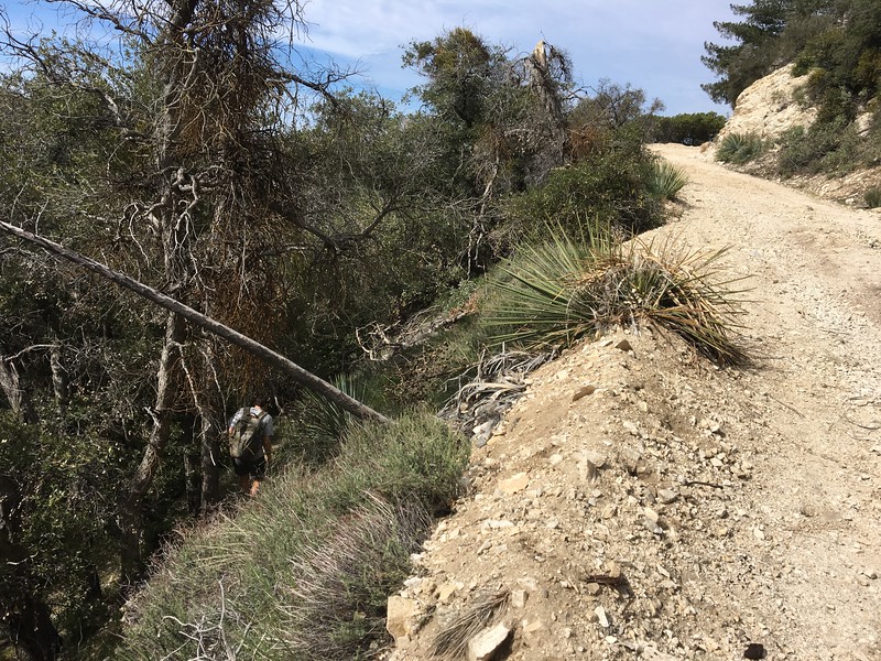
TFitz and I started riding up Sunset Ridge at 7:30AM on Sunday, when the little parking lot at the gate was already full. The ride up was uneventful, and we were at Alpine Tavern shortly. Before we left I made a half-assed attempt to locate the crash site via historical aerials. This didn't work, but I did notice some sort of cabin just west of the main Alpine Tavern site that was still standing in 1960. This was at the tip of a minor ridge. The first order of business was to go find the ruins to see if there's anything still there. We bushwhacked to the site, only to find a perfectly-maintained trail coming in from a different direction when we got to the spot. Oh well. There's no cabin here anymore, but instead there's a memorial to James T. Spencer who apparently led a train-maintenance crew in this area:

Image

Image

The site also has supports for guy wires, and some downed power poles that presumably were held up by these guy wires at some point

Image

Does anybody know the history here? The train was electrified; does this mean that all the buildings had power lines running to them as well? And the power lines for the train: were those running overhead? If so, was this thing I found below, in Grand Canyon, a power tower for the train?

Image

In any case, an information panel at the Alpine Tavern site says that the hotel was abandoned in 1936 (I think; might be a bit off), and was dynamited by the forest service in 1959 to facilitate construction of the campground. This is quite puzzling since this campground doesn't really have any facilities. And I wish the original buildings were still around; even in ruined form. But that's not up to me, so the drainage below the tavern (Grand Canyon) is FULL of old detritus. In addition to old junk, there's an extensive pipe system for transporting water in and around the canyon for a LONG way below Alpine Tavern. There's a lot of piping and lots of valves, junctions and things. Anybody know what this was for? Presumably the water supply for the Alpine Tavern itself came from above. What would be the purpose of the piping below?

We dropped into the channel and started our descent. Initially the channel is dry, but quickly gets a little bit of water, which comes and goes. The flow would be better during a wetter year. The channel is generally wide, brush-free and easy to traverse, except for a small number of obstacles. Soon after we left Alpine Tavern, we encountered a number of small waterfalls that could be bypassed on our left without a lot of fuss.

Image

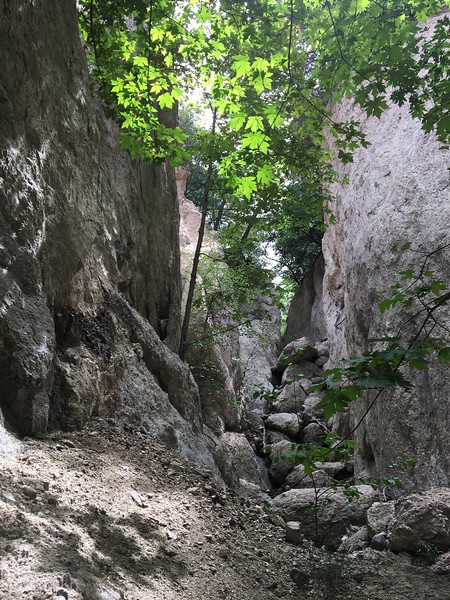
These were straightforward, but we then hit a more serious obstacle: the canyon narrowed into a tight slot with vertical walls, and the ground immediately dropped off into a waterfall.

Image

There was some accumulated deadfall between us and the lip of the slot, so it wasn't clear how tall the waterfall was, or how many tiers it had. It DID look unwise to try to descend it directly, so we found a bypass on the left. This was a good use trail that contours in a wide arc around this waterfall (that turned out to be quite large), and deposits you into the streambed below. In the process it passes near the edge of the very dramatic bowl in front of the slot, and presents a fantastic view of the falls at the mouth of Alpine Canyon (which are also here, and are BIG):

Image

On this day it was too dry for these to work well, but mid-winter this place should be spectacular. During this bypass we noticed a flat area further up. We scrambled up expecting to see foundations and/or a chimney of an old house, but found none. There was only an old water pipe, an old valve and an odd mildly excavated area with some bricks strewn around

Image

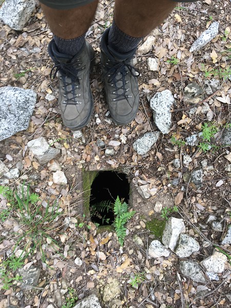
Weird. There were a few of these flat areas around, so we went over to the next one. There were some odd holes in the ground here. Clearly they were meant to look like this:

Image

But they're old, and most looked like this

Image

or even like this

Image

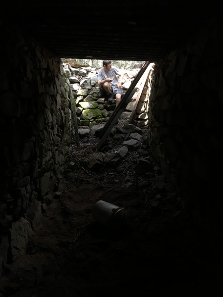
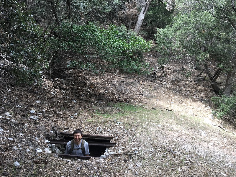
This latter one had a sufficiently-broken roof so that you could descend into it:

Image

I don't get it. Somebody did a LOT of work here, but for what purpose? Each of these grottos has an earthen floor, and walls made of stacked rocks. Some of the walls are round and some are square, but all have walls that go all the way around, with no openings. I.e. each of these is a single room. The biggest one is high enough to comfortably stand in, maybe is 6ft wide, and maybe 25ft long. The roof is salvaged rail interspersed with salvaged brick:

Image

These are REALLY cool, and there're a number of them. But what in the world are they for? These aren't mines. Nor are they houses. Maybe they're storage for something, but what? The intact ones only have a single tiny opening in the ceiling. Water storage is the only thing that makes sense, but I can't imagine these are watertight. And what would they be storing the water for? These aren't near anything! Alpine Tavern is a ways above, along the creek bed. And the railroad was a ways above, straight up? Somebody please explain.

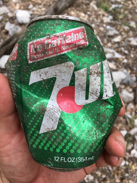
So anyway. While looking around, we saw an area with what looked like it could be black tubing. Above were bright-green plants, and there was what looked sorta like a campfire near it. The first thought that this was an active grow, but that didn't make much sense up here. I carefully walked up. The "black tubing" turned out to be this very snazzy and not-very-old ladder:

Image

The plants were ferns or poison oak, that were lit up just right to look very abundant and very green. And the campfire was this:

Image

also looking very shiny in the sun. So yeah; that was exciting. This place raised more questions than answers, so we kept going, dropped back down into the streambed, and backtracked to see the waterfall slot from the bottom:

Image

It actually looked climbable, but the rock is terrible, and it wasn't worth the risk. The terrible-ness of the rock was evidenced by the massive exposed roots of the local trees:

Image

We then walked to the base of the Alpine Canyon falls. The photos don't do these justice. They're awesome.

Image

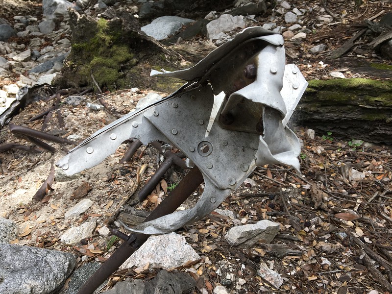
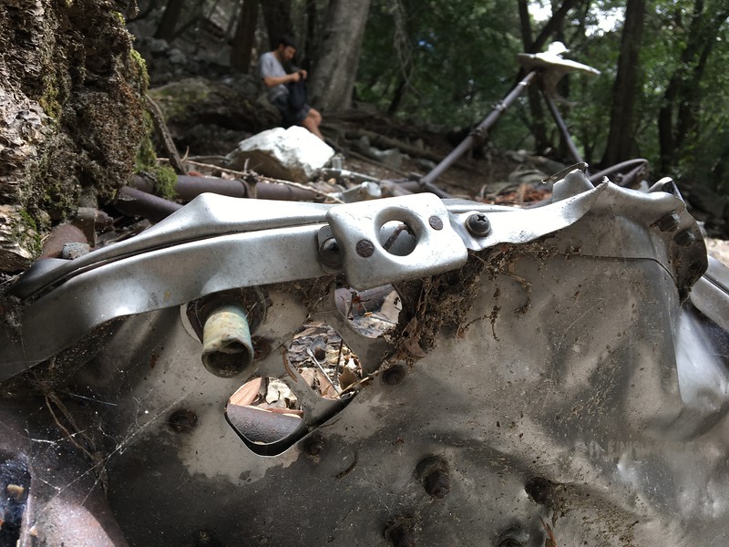
Yeah. What was this trip about, again? Oh yeah. Airplanes. We kept descending in the canyon, looking for plane parts. This required picking them out from Alpine Tavern parts, which were abundant. Eventually we found some:

Image

Image

Image

Image

It's the skeleton of the airplane (made of iron, apparently), some attached bits of aluminum skin, and some sort of wing or fuselage thing. Neat! We walked downstream a bit to see if anything else washed down. Nothing. (Or more likely, we didn't descend far enough). We then came back, and looked around some gullies directly above this area. Again, nothing. I feel like there should have been something, but there wasn't. We probably weren't in the exact right gully, or something. It's a bit odd that there weren't any breadcrumbs at all: just the above-pictured pieces in the channel bottom. Eventually we gave up, and called it a day. At some point this would be a good place to revisit, but I'm not in a hurry.

We took a slightly different route on the way back: between the road and stream. This resulted in more stuff being found. Here're more of what I think could be fallen power towers:

Image

And some sort of collapsing retaining wall:

Image

Apparently the concrete was poured over a bed of rocks:

Image

Almost at the Alpine Tavern site was a drainage pipe crossing the road. Inside was a cool, LONG lizard (click on the images for the full-size originals!):

Image

Image

Image

He didn't want to hang out with me, but he REALLY didn't want to be stuck in the shaded pipe. So he walked to the edge and jumped out.

And that's it. This is a really cool canyon. I now want to go back and traverse the whole thing, even though it's now missing 17 birthday balloons, not counting this festive S, and this kickass giraffe:

Image
User avatar
stonehillnews
Posts: 72
Joined: Thu Dec 15, 2016 1:31 pm

Post by stonehillnews »

You were in the sewer system from the Alpine Tavern. I was just there with a group of FS volunteers in January or so, doing a bit of that sewer system excavating you saw. Brian Marcroft has tons of documentation on it. The large dramatic falls are Chapman Falls.
User avatar
stonehillnews
Posts: 72
Joined: Thu Dec 15, 2016 1:31 pm

Post by stonehillnews »

The ladder looks like part of a bow hunter’s blind
User avatar
dima
Posts: 1349
Joined: Wed Feb 12, 2014 1:35 am

Post by dima »

Sewer system??? Explain. How is the stuff supposed to get in? And out? Today there isn't any obvious plumbing connected to the grottos. Were the pipes running across the top before?
User avatar
stonehillnews
Posts: 72
Joined: Thu Dec 15, 2016 1:31 pm

Post by stonehillnews »

You have photos of some of the pipes and valves. These are the cesspools where the effluent was sent by gravity. That’s why they are downhill.
User avatar
dima
Posts: 1349
Joined: Wed Feb 12, 2014 1:35 am

Post by dima »

Well yeah, but currently the pipes don't connect to any of the tanks. They're just sort of in the area. Were they connected directly previously?
User avatar
stonehillnews
Posts: 72
Joined: Thu Dec 15, 2016 1:31 pm

Post by stonehillnews »

I think the tanks spilled over one to the next. They were connected to each other. Brian has some of the old engineering drawings. They might show more of the plumbing details.
User avatar
headsizeburrito
Posts: 279
Joined: Wed Nov 15, 2017 1:18 pm

Post by headsizeburrito »

Looks like some fun exploration with a little bit of everything! Glad you can check another plane off your list. Great photos and good work on the balloon haul, that's a pretty sweet giraffe!
User avatar
Sean
Cucamonga
Posts: 3782
Joined: Wed Jul 27, 2011 12:32 pm

Post by Sean »

The first falls you bypassed are called Grand Canyon Falls. I think you found the known plane wreckage. I haven't heard of another site. There are lots of other things to look for around Grand Canyon, but they are semi-secrets. Here is some info about James Spencer. Oh, and Chapman Falls is also called Alpine Falls. Joseph Chapman logged the area in the early 1800s. Then the Alpine Club moved in later.
User avatar
TFitz
Posts: 3
Joined: Tue Apr 10, 2018 7:42 pm

Post by TFitz »

A few of my phone photos that aren't too redundant of Dima's:

Image
Descending into some pointless bushwhacking.

Image
In the sewer that I didn't know was a sewer.

Image

Image
This didn't look terribly old, but I definitely didn't remember that slogan. Looked it up and found this funny commercial from 1982:

Image

Image
The grandest part of the canyon.

Image

Image

Image

Image
On the way down.
User avatar
dima
Posts: 1349
Joined: Wed Feb 12, 2014 1:35 am

Post by dima »

stonehillnews wrote: Brian has some of the old engineering drawings. They might show more of the plumbing details.
Does Brian also have a website? I'd love to see some details.

Sean wrote: I think you found the known plane wreckage. I haven't heard of another site.
We found SOME of it, but the wreck-oriented trip reports show a lot more stuff above... Somewhere.

Sean wrote: There are lots of other things to look for around Grand Canyon, but they are semi-secrets.
I don't have other people's secrets, but I can make my own :)
User avatar
dima
Posts: 1349
Joined: Wed Feb 12, 2014 1:35 am

Post by dima »

stonehillnews wrote: I was just there with a group of FS volunteers in January or so, doing a bit of that sewer system excavating you saw.
Oh, and another thing. You were excavating these tanks? Were they full of sediment before you got to them?
User avatar
stonehillnews
Posts: 72
Joined: Thu Dec 15, 2016 1:31 pm

Post by stonehillnews »

dima wrote:Oh, and another thing. You were excavating these tanks? Were they full of sediment before you got to them?
No, these were settling tanks. I think there was never very much in the way of solids. They were meant to catch the mainly liquid effluent and let it percolate into the ground.

Brian had just dug up some drawings which showed additional tanks he hadn’t been aware existed, so we were looking for those.

PS I guess you saw the email I sent to try to get him into a thread about the drawings?
User avatar
David R
OG of the SG
Posts: 534
Joined: Sun Jun 12, 2011 10:28 pm

Post by David R »

Today I went from the bottom up in my search for the cabins. I found them about an 1/8 of a mile below the airplane parts. There are the remains of three cabins. The further down you go the worse shape they are in. The one highest up has 1/2 of the wall standing and a chimney as well as some miscellaneous household items. Someone has been here relatively recently as there are ribbons tied in this area coming from upstream. I did try to climb a gully where I found a rusted out box , in the hope of find some other ruins but nada. I did find another ribbon a hundred feet up that gully, making me wonder if there is another route people took to get down to these cabins from the fire road or it was just a lost hiker wondering around.

The route up is straight forward with the only annoyance lots of downed trees in the stream bed. The area near the cabins is delightful with nice flat benches, tons of trees, and lots of deer. Great spot for an isolated backpack trip. Just below that area there was even some water flowing.
User avatar
Sean
Cucamonga
Posts: 3782
Joined: Wed Jul 27, 2011 12:32 pm

Post by Sean »

David R wrote: Someone has been here relatively recently as there are ribbons tied in this area coming from upstream.
We might restore an old trail in that area. Hence the flagged routes.
User avatar
dima
Posts: 1349
Joined: Wed Feb 12, 2014 1:35 am

Post by dima »

A few days ago I hiked up through Millard Canyon up to Grand Canyon to the crash site. Piggybacking off this thread for the report.

The trail through Millard is in great shape. Thanks, trail builders! There're even intact signs at all the junctions. There's a bit of flow in the creek; it'll get more as we get more rain, hopefully. We went up to Saucer branch falls. My recollection is that this is a dramatic, big single-tier cascade. Either my memory is off, or these falls were reshaped by last season's rains. It's now very overgrown, so the falls aren't visible from the bottom, even if you bushwhack to their base. And there's a big cluster of plants in the middle of the drop, so it's now a 2-tier falls. Was it like that before?

Dawn mine still has a metal grate at the opening (i.e. nobody has pulled it off yet). Past the turnoff to Tom Sloan saddle, Grand Canyon is a bit brushy, but it's really not terrible at all. After a bit of effort you break through the brushy section, and the canyon opens up. At this point the going became easier, and we arrived at an old neighborhood of cabins. All are ruined, but many still have their rock walls, and there's lots of metal debris around, like old cookware. Today, the biggest cabin is a good place to camp, and the fireplace is still useful for its original purpose. And some contemporary visitors clearly know this.

Image

A bit past that was the air frame from the last time. Looks the same:

Image

THIS time I really wanted to find the rest. I looked around, and decided to climb the canyon wall directly above the frame. This was a good decision, since we started finding debris almost immediately. No idea why we didn't do this the last time. There're some small pieces. As we climbed up, we found bigger and bigger pieces

Image

Until we got to the top of the debris field where the whole left wing was sitting

Image

Image

Image

I climbed above the wing to confirm that this was indeed the top, which it was: no more debris above. We really didn't need to climb very high, so the crash happened nowhere near the ridge. No idea what the pilot thought he was doing.

We then visited the septic tanks from the last time. I wanted to follow the pipe, further downcanyon, and it led us to more tanks. The rest are relatively small, and round. The roof has concrete covering the bricks and rails, and there's a single pipe in the center:

Image

There're a number of these. The last one has some large ceramic pipes sitting next to the tank. These are ceramic, but nevertheless have threads!

Image

Then we climbed up to the road, and walked back down to the city. Of note is that near the powerline towers the road passes the burn are from the event a few months ago. The place is charred, but the firefighters must have knocked it down quickly. And we now have a few more firebreaks to use as shortcuts!
User avatar
dima
Posts: 1349
Joined: Wed Feb 12, 2014 1:35 am

Post by dima »

And for the record, this plane is an AT-6 Texan that went down in 1947:
Young_Flyer's_Body_Taken_Off_M.pdf
(162.33 KiB) Downloaded 72 times


Four_Brush_Fires_Rage_Across_S.pdf
(201.82 KiB) Downloaded 69 times
User avatar
Sean
Cucamonga
Posts: 3782
Joined: Wed Jul 27, 2011 12:32 pm

Post by Sean »

dima wrote: And there's a big cluster of plants in the middle of the drop, so it's now a 2-tier falls. Was it like that before?
Do you have a picture? We tried to climb Saucer a couple years ago.

User avatar
tekewin
Posts: 1195
Joined: Thu Apr 11, 2013 5:07 pm

Post by tekewin »

I was at Saucer Branch in March and you could see both tiers from just off the trail. I thought it was always 2-tier. Sounds more overgrown now. Nice find on the airplane. There used to be a bear cub carcass just below the cabins, but some trees fell on it and buried it before March.
User avatar
dima
Posts: 1349
Joined: Wed Feb 12, 2014 1:35 am

Post by dima »

Sweet action video! I guess it was always multi-tier, there's just more vegetation at the bottom and in the middle now. tekewin: tell me you now have a taxidermied bear head staring at you when you wake up each morning.
User avatar
walker
Posts: 248
Joined: Mon Apr 08, 2013 11:14 pm

Post by walker »

The main tiers of the falls can be seen rather nicely from a few spots along the sunset trail system on the other side of the canyon.

Looks like a pretty dicey climb up the left side from that video! I've climbed into Saucer branch by gaining the right ridge about a hundred yards away from the falls before the canyon is cliffs on all sides. You can take that ridge system up to a rocky band about 150 feet above the falls, then traverse around a high shoulder and descend into the canyon a little bit above the falls. Pretty dramatic gorge, very steep in there and lots of rocks apparently balanced on sand or held in place by twigs, just waiting for something to tip them off balance. Didn't make it up the gorge far enough to see remains of any of the mine stuff or any sign of the legendary hanging cabin.
User avatar
tekewin
Posts: 1195
Joined: Thu Apr 11, 2013 5:07 pm

Post by tekewin »

dima wrote: Sweet action video! I guess it was always multi-tier, there's just more vegetation at the bottom and in the middle now. tekewin: tell me you now have a taxidermied bear head staring at you when you wake up each morning.
Sadly, no bear head.
User avatar
dima
Posts: 1349
Joined: Wed Feb 12, 2014 1:35 am

Post by dima »

Walker: I climbed around the falls with a wide bypass on the right, which sounds like what you did. I didn't know where any of the artifacts were, so I didn't find any. Do you have any info about the cabin?
User avatar
CrazyHermit
Posts: 343
Joined: Mon Sep 07, 2015 1:03 pm

Post by CrazyHermit »

Sean wrote: dima:
Do you have a picture? We tried to climb Saucer a couple years ago.

I was able to get up on top of those falls a few years back. At first I tried the left side like you did. There was some rigging up at the top, but it looked pretty shaky. Then I came back and went up from the right side through the brush. The top is massively overgrown. Took me about half an hour to go 500 feet, but there are water pipes up there. At the very back of the canyon there an old mine. The miner supposedly built this bizarre cabin that was suspended above the canyon floor by cables to keep it from getting washed away. Don't know what became of it, but I don't think its ever been found.
User avatar
dima
Posts: 1349
Joined: Wed Feb 12, 2014 1:35 am

Post by dima »

Did you find the mine? The cabin was nearby, presumably.
User avatar
CrazyHermit
Posts: 343
Joined: Mon Sep 07, 2015 1:03 pm

Post by CrazyHermit »

Wasn't able to get all the way to the back of the canyon, which is where it is. The overgrowth was horrific. But there's a way to come in from the back side and climb down, I'll try it one of these days. Missy from angelesadventures.com was able to reach it years ago. She said the mine wasn't that deep and never did find the cabin. There's an excellent writeup on her site.

Image
User avatar
walker
Posts: 248
Joined: Mon Apr 08, 2013 11:14 pm

Post by walker »

This description mentions the hanging cabin and cites John Robinson, maybe he mentions it in his book on san gabriel mines? Not sure if there's any original source documentation to back it up:

http://www.dankat.com/advents/saucer.htm
User avatar
walker
Posts: 248
Joined: Mon Apr 08, 2013 11:14 pm

Post by walker »

Brennan also mentions a plane crash in the same page linked above!
User avatar
CrazyHermit
Posts: 343
Joined: Mon Sep 07, 2015 1:03 pm

Post by CrazyHermit »

I have John Robinson's description of it somewhere. I think it was in Mines of the San Gabriels. Can't seem to find his book at the moment, but apparently the mine had no known name and the miner's name was unknown as well. Hard to believe he was able to transport ore out of that location, but at least he wasn't likely to get claim jumped back there. Christopher Brennon is a great source. He was a professor at Cal Tech and did some crazy canyoneering. I really like reading the descriptions of some of the places he's been to.
Post Reply