
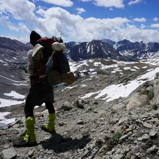
We started later than expected on the first day, 2pm, and weren't used to our pack weight (39.6lbs) so we only made it a few miles the first day. We stealth camped near Echo Mountain down towards the waterfalls, which was fun but also unsettling knowing so many people go up to Echo Mountain to party at night. All was well though and in the morning we awoke in a cloud of fog moving over the ridge and throughout the forest around us. It was eerie, spooky and incredibly cool.
We then started our 2 1/2 mile trek uphill towards Inspiration Point. We spent the morning walking through clouds and passing small trickles of water down granite rocks as we reached Inspiration Point at nearly 4,500ft. After a break and talking with some other hikers, two of which are about to do 8 days on the Pacific Crest Trail we got movin' to our next point - Mount Lowe Trail Camp a mile down the fire road that Inspiration Point is on.
Upon reaching the trail camp we were greeted by two scout leaders and two volunteer park rangers who informed us that 35 Scouts were on a trek to the campground and that it may not be the most quiet place to stay for the night. So, with that news we took a break and pondered our next move... We decided to continue on towards Bear Canyon Trail Camp, which was our original destination for the night before our setback the day before.
The Tom Sloan Trail from Mount Lowe Trail Camp to the Tom Sloan Saddle was trecherous to say the least. It ran mostly along granite cliffs, with a tight trail barely large enough for someone with a pack on to walk down without scraping the wall. The views were sweeping, beautiful and at time scary but we pushed on to the saddle. Once there, a sigh of relief, a nap and snack then onward 2 more miles to our camp. Heading down the trail to Bear Canyon CG from the Saddle was also clear that we were the first ones to walk on that trail in days, maybe weeks. The views were of the backcountry, fullly green and huge pine trees that have luckily made it through many burn years. It was reminescent of the Sierras with the sweeping greenery.
When we finally made it down the switchbacks to Bear Creek - that was a whole new set of challenges. Again, no one had hiked this trail so there were no crossings made when we had the cross the creek FOURTEEN TIMES! So, we took it upon ourselves to move downed logs to form bridges and large rocks for stepping stones so the next hikers are a little more fortunate. After what seemed like hours, we made it the two miles to the campground and were blown away. Such a gem in the middle of the forest and complete with fire pits, many tenting spots and 100+ year old stoves to with flat tops to cook anything on.
After an amazing night with a campfire and sleeping under a cloudless sky we had a late start out of camp at 10am and made our way back up the creek we built bridges for the day before, back up to the Tom Sloan Saddle and then down a couple miles towards Dawn Mine. Reaching the creek that runs along the Dawn Mine trail was another surprise. SO MUCH water in the Angeles Nat'l Forest right now! It's pretty amazing. Again, we had many crossings but only five this time but many more downed trees. It looked as though no one had hiked from the Tom Sloan Saddle to Dawn Mine recently, either.
Another quick break at the Mines for lunch then we set off on a spur trail that leads to Mount Lowe Rd., which turned out to be the sketchiest, tiniest trail of the trip. It was practically all up, which I knew from TOPO maps but I did not imagine how small the trail was and the sheer drops on the other side. It seemed as though a lot of the trail had eroded throughout the winter. There were many spots where you had to turn and side step to not hit the wall of the trail but yet, there was a sheer drop. I do not recommend anyone going down this trail with a pack. Amazing views, but not worth it.
Along the way I picked up someone's tank top that must have fallen off and found them at the road. When I gave it back to them they said it looked like we weren't even on a trail (even though we were). Just goes to show how tight that trail really was.
Once reaching Mount Lowe Rd. we spoke with some other day hikers and cyclists about our adventures the last two days and continued towards Cape of Good Hope and then finally catching the old trolley route trail from Mount Lowe Rd. over to Echo Mountain. We had one last break and meal next to where we camped two nights prior as a beautiful full circle to our trip.
All in all it's the perfect time to go backpacking in the Angeles National Forest. There's plenty of water and the temperatures aren't too crazy either hot or cold. Just make sure to go prepared, research your routes and Leave No Trace.
Hope this inspires or helps you in planning your next trip!
3 Day Backpacking including Mount Lowe Trail Camp -> Tom Sloan Saddle -> Bear Canyon CG -> Dawn Mine -> Echo Mountain
-
AnthonyEKing
- Posts: 24
- Joined: Mon Mar 25, 2019 3:45 pm
You do not have the required permissions to view the files attached to this post.
-
AnthonyEKing
- Posts: 24
- Joined: Mon Mar 25, 2019 3:45 pm
...and more photos continuing northwest on the Tom Sloan Trail towards the Saddle and down to Bear Creek.
You do not have the required permissions to view the files attached to this post.
-
AnthonyEKing
- Posts: 24
- Joined: Mon Mar 25, 2019 3:45 pm
& more photos from Bear Creek the next morning towards Dawn Mine / Mount Lowe Rd. Spur junction.
You do not have the required permissions to view the files attached to this post.
-
AnthonyEKing
- Posts: 24
- Joined: Mon Mar 25, 2019 3:45 pm
& the route
You do not have the required permissions to view the files attached to this post.
-
Anthony

- Posts: 332
- Joined: Mon Jun 05, 2017 11:53 am
39 lbs...yikes!
Sounds like a fun trip though. I hit Bear Mountain via Tom Sloan Saddle yesterday. I've been wanting to do an overnighter at Bear CG for years. It sounds like a relatively secluded CG considering its close proximity to the city.
Sounds like a fun trip though. I hit Bear Mountain via Tom Sloan Saddle yesterday. I've been wanting to do an overnighter at Bear CG for years. It sounds like a relatively secluded CG considering its close proximity to the city.
-
Uncle Rico

- Posts: 1481
- Joined: Thu Mar 20, 2008 7:48 pm
Nice trip. After reading the other Anthony's TR about Brown Mtn, I was wondering about the condition of the route through Bear Canyon so appreciate the update. Looks like it's still the path less traveled.
-
AnthonyEKing
- Posts: 24
- Joined: Mon Mar 25, 2019 3:45 pm
I'm pretty sure I saw you at the Tom Sloan Saddle on Sunday morning. We had just rested there for about a half hour and went down the Dawn Mine Trail as I looked back a few minutes later to say bye to the Saddle I saw someone with a bright blue shirt on. Was that you? Which route did you take to the Saddle? The sketchy Tom Sloan Trail or the Mount Lowe Fire Rd.?Anthony wrote: 39 lbs...yikes!
Sounds like a fun trip though. I hit Bear Mountain via Tom Sloan Saddle yesterday. I've been wanting to do an overnighter at Bear CG for years. It sounds like a relatively secluded CG considering its close proximity to the city.
How's that hike up to Brown Mountain, also?
You should definitely check out Bear Canyon CG. From the Saddle it isn't that hard to get to besides a bunch of stream crossings but I know you can get there from Switzer Falls, also, which seems about the same distance as coming from Dawn Mine or Cobb Estate (a bit longer).
Oh and thankfully, we weighed our packs when we got back to the car and my friend lost 15lbs on hers and I lost 9lbs on mine. My base weight was 19.2lbs, so just imagine how much food I had haha. I like to be prepared, ya never know.
-
AnthonyEKing
- Posts: 24
- Joined: Mon Mar 25, 2019 3:45 pm
The trail is in great shape from the Saddle to Bear Canyon CG. It's marked by red tape on trees in some parts, guessing from when it was full of snow. Besides the stream crossings, it's relatively easy to follow and get to. Definitely worth it.Uncle Rico wrote: Nice trip. After reading the other Anthony's TR about Brown Mtn, I was wondering about the condition of the route through Bear Canyon so appreciate the update. Looks like it's still the path less traveled.
-
Anthony
- Posts: 332
- Joined: Mon Jun 05, 2017 11:53 am
What about from Bear CG to Switzer? I remember that being very overgrown a few years back.AnthonyEKing wrote:The trail is in great shape from the Saddle to Bear Canyon CG. It's marked by red tape on trees in some parts, guessing from when it was full of snow. Besides the stream crossings, it's relatively easy to follow and get to. Definitely worth it.Uncle Rico wrote: Nice trip. After reading the other Anthony's TR about Brown Mtn, I was wondering about the condition of the route through Bear Canyon so appreciate the update. Looks like it's still the path less traveled.
-
AnthonyEKing
- Posts: 24
- Joined: Mon Mar 25, 2019 3:45 pm
I'm not too sure about that route but while we were in the campground that night there were two other groups that came from that direction. Two couples and two guys in their 20s, so just based on the amount of people I'd guess it's a bit easier in the long run. We didn't see anyone between Mount Lowe Trail Camp, along the Tom Sloan Trail down into Bear Canyon.
-
David R
- OG of the SG
- Posts: 630
- Joined: Sun Jun 12, 2011 10:28 pm
I did the entire route as a loop from Red Box. Some one last fall cleared up the route from the top of Bear Canyon to the CG where it used to be a complete bushwhack and put up the tape you saw on the trees for their route creation. From the CG to Switzer is a clear trail with no issues. Both trails from Mt Lowe fire road to the saddle were in fine shape prior to the rains.
-
Anthony
- Posts: 332
- Joined: Mon Jun 05, 2017 11:53 am
Cool loop idea. I assume you ascended/descended the Valley Forge Trail to/from Eaton Saddle?David R wrote: I did the entire route as a loop from Red Box. Some one last fall cleared up the route from the top of Bear Canyon to the CG where it used to be a complete bushwhack and put up the tape you saw on the trees for their route creation. From the CG to Switzer is a clear trail with no issues. Both trails from Mt Lowe fire road to the saddle were in fine shape prior to the rains.
-
AnthonyEKing
- Posts: 24
- Joined: Mon Mar 25, 2019 3:45 pm
Isn't it the Gabrielino Trail that goes from Red Box Picnic Area over to Switzer?
-
Anthony
- Posts: 332
- Joined: Mon Jun 05, 2017 11:53 am
Part of it, yes. He said he did a loop though, and the Gabrielino isn't a loop and it doesn't pass thru Bear CG or Tom Sloan.AnthonyEKing wrote: Isn't it the Gabrielino Trail that goes from Red Box Picnic Area over to Switzer?
-
AnthonyEKing
- Posts: 24
- Joined: Mon Mar 25, 2019 3:45 pm
Oh I know it isn't a loop... I was just confirming that was the name of the trail that goes from Red Box to Switzer, haha. All good  I had taken it once over to Switzer from the picnic area but haven't made it into a loop. What David did sounds like a good idea.
-
psykokid
- Posts: 80
- Joined: Fri Mar 18, 2016 1:15 am
I did the same route as David. I think he did it clockwise from Eaton Saddle whereas I did it counterclockwise. Unfortunately, when I did that loop someone hadn't been through and cleaned up the stretch from Bear Canyon Trail Camp to the Stone Hut and it it was quite the bushwhack. I had run or jogged the majority of the trail up to that point. I went back and looked at my GPS track and it took me an hour to cover that mile of trail ?, whereas I had made it from Eaton Saddle to the Bear Canyon Jct in just a smidge over two hours..David R wrote: I did the entire route as a loop from Red Box. Some one last fall cleared up the route from the top of Bear Canyon to the CG where it used to be a complete bushwhack and put up the tape you saw on the trees for their route creation. From the CG to Switzer is a clear trail with no issues. Both trails from Mt Lowe fire road to the saddle were in fine shape prior to the rains.
I ran the tom Sloan Trail couple of months ago and found it to be in good shape, and it seemed more than adequately wide in most places. I guess ones wide can be anothers narrow..
-
David R
- OG of the SG
- Posts: 630
- Joined: Sun Jun 12, 2011 10:28 pm
The route is Red Box along the road to JPL trail to Mt Disappointment, hop over San Gabriel peak trail to Mt. Lowe Fire Road and you can figure out the rest.
-
JeffH

- Posts: 1349
- Joined: Sun Nov 28, 2010 7:09 am
This sounds like a great trip!
I also have a tendency to carry too much food, plus you were carrying more than all dried stuff. When I return from backpacking trips I still have a couple of days remaining.
I also have a tendency to carry too much food, plus you were carrying more than all dried stuff. When I return from backpacking trips I still have a couple of days remaining.
"Argue for your limitations and sure enough they're yours".
Donald Shimoda
Donald Shimoda
-
hikeandhike
- Posts: 46
- Joined: Mon Sep 09, 2013 7:20 pm
The photos are excellent. Thanks for the report!
Did you see any fish in Bear Canyon? Or otherwise along the trip?
Did you see any fish in Bear Canyon? Or otherwise along the trip?
-
Sean

- Cucamonga
- Posts: 4250
- Joined: Wed Jul 27, 2011 12:32 pm
Thanks for the TR and photos. Anything spooky happen at night? That area has a bunch of bears.
-
AnthonyEKing
- Posts: 24
- Joined: Mon Mar 25, 2019 3:45 pm
Thanks!hikeandhike wrote: The photos are excellent. Thanks for the report!
Did you see any fish in Bear Canyon? Or otherwise along the trip?
I saw some minnows throughout Bear Canyon, but no fish of any size. Might be worth checking out now that it's a few weeks later.
-
AnthonyEKing
- Posts: 24
- Joined: Mon Mar 25, 2019 3:45 pm
Nope! We had no issues with animals either night. I figured there was a lot of bear activity from the name, but we didn't even see droppings or tracks.Sean wrote: Thanks for the TR and photos. Anything spooky happen at night? That area has a bunch of bears.