Shortcut has been cut off!

TRs for the San Gabriel Mountains.
Post Reply
User avatar
Tom Kenney
Posts: 385
Joined: Sat Sep 29, 2007 7:51 pm

Post by Tom Kenney »

I did a Rincon->Shortcut->CA-2 loop mostly on the bike yesterday, and wound up doing a bit of class 2 scrambling and some bushwhacking for good measure. There was still patchy snow all the way down to West Fork CG on the Rincon Road, and lots of water everywhere.

There are plenty of land/mud slides blocking the road, but below are 2 pics of the most serious. This slide is about 1km north of Rincon Road, and right at the base of a powerline tower. Debris covers the start of a spur road to 2 towers. The nearest tower is in danger of losing one concrete footing, which is within 1m of the edge of the slide. I managed to go up and over the debris cone, passing between the trees above/right of the yucca in foreground.
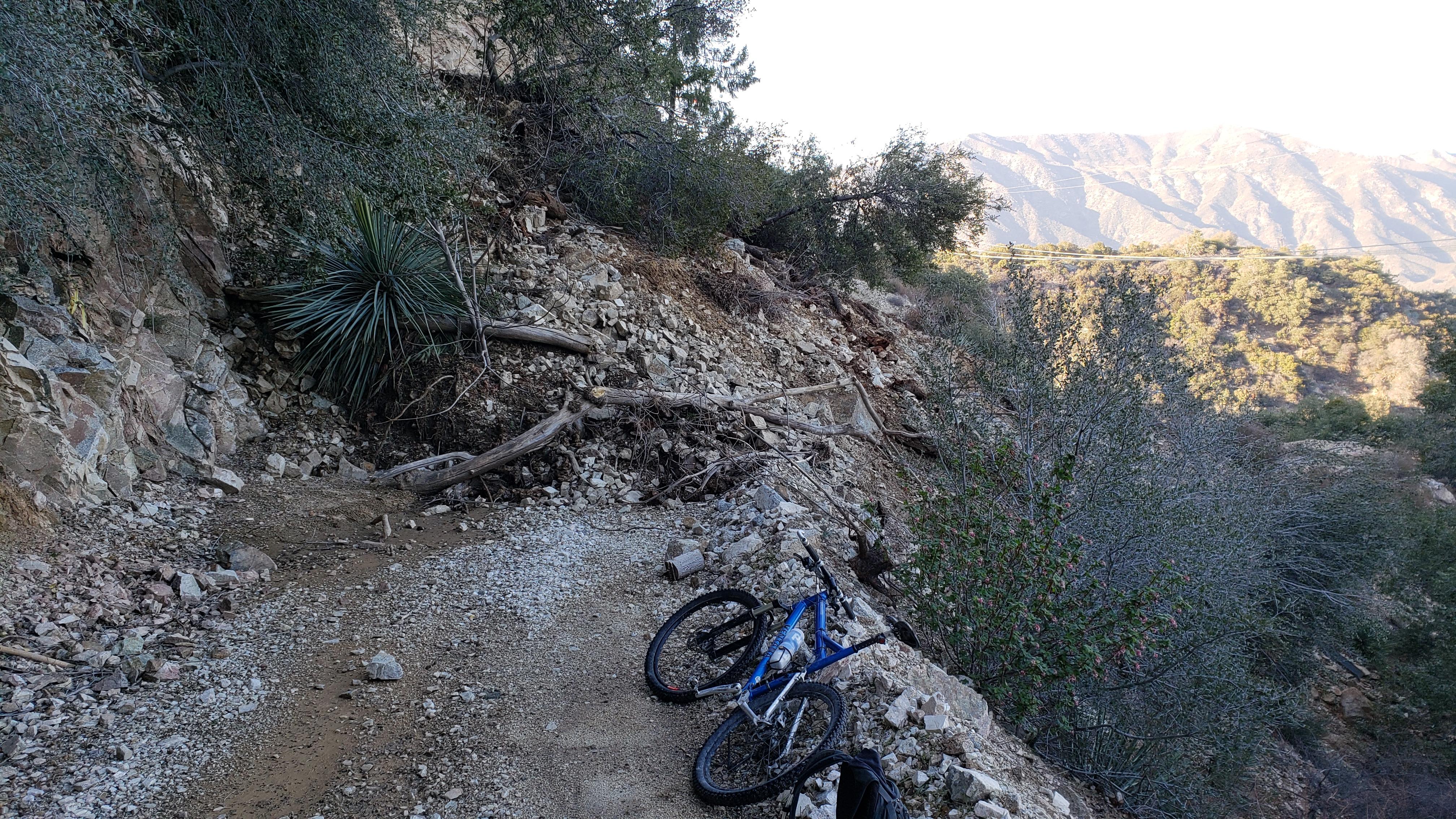
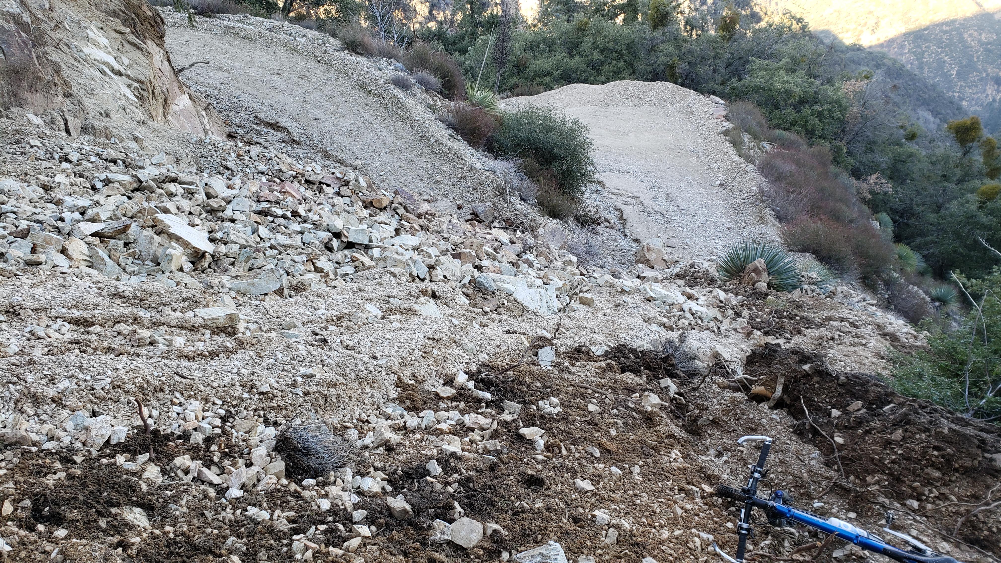
Image

Image

On my way up the other side of the canyon I passed a backpacker coming down the road. We spooked eachother pretty good, since it was dark and neither of us were using lights (I was conserving battery). I took this as a sign that the highway had been opened again, and thought no more of it for a while. Once I reached the highway I saw no cars parked. Also, I hadn't seen much traffic. When I got to Barley Flats Road, the gate across the highway was locked. Hmmm....

It wasn't cold enough for ice, and the highway was clear, but my puzzlement was squashed presently. I passed 2 excavators parked along the road, then saw a large, vaguely earth-colored mass nearing in my headlight. The road had been buried edge-to-edge for 150mW X 100mH by a huge landslide. A single truck-width 'lane' had been cleared, but the reason for total closure of the highway was no longer a mystery.

In other news...

My wife and I managed to summit Sandstone Peak on Sunday, but we had to bypass the sizeable snowfield below the summit headwall as we had neglected to bring crampons and ice axes. (80% of that statement is a fib, but the part about snow is Dog's Own Truth!)
User avatar
Sean
Cucamonga
Posts: 4052
Joined: Wed Jul 27, 2011 12:32 pm

Post by Sean »

I heard about that slide on ACH. I bet it was trippy going through the corridor.
User avatar
Anthony
Posts: 327
Joined: Mon Jun 05, 2017 11:53 am

Post by Anthony »

Tom Kenney wrote:There are plenty of land/mud slides blocking the road, but below are 2 pics of the most serious. This slide is about 1km north of Rincon Road, and right at the base of a powerline tower. Debris covers the start of a spur road to 2 towers.
Good report! Just to be clear: Rincon has the slides, not the Shortcut Canyon Trail (Silver Moccasin Trail)?
User avatar
Tom Kenney
Posts: 385
Joined: Sat Sep 29, 2007 7:51 pm

Post by Tom Kenney »

Anthony wrote:
Good report! Just to be clear: Rincon has the slides, not the Shortcut Canyon Trail (Silver Moccasin Trail)?
I didn't take any of the trails yesterday, just roads. Some minor slides on Rincon Road, the major one in my pics is on Shortcut Road. I wouldn't be surprised if there's some storm damage on the trails, but it is usually deadfall or minor rockfall.
User avatar
Anthony
Posts: 327
Joined: Mon Jun 05, 2017 11:53 am

Post by Anthony »

Do you have a GPX?
User avatar
Tom Kenney
Posts: 385
Joined: Sat Sep 29, 2007 7:51 pm

Post by Tom Kenney »

Anthony wrote: Do you have a GPX?
I wasn't tracking yesterday. I've got an older track of the same route, and I can mark the approx location of the slide. I'll try to get it done tomorrow AM.
User avatar
Anthony
Posts: 327
Joined: Mon Jun 05, 2017 11:53 am

Post by Anthony »

Tom Kenney wrote:
Anthony wrote: Do you have a GPX?
I wasn't tracking yesterday. I've got an older track of the same route, and I can mark the approx location of the slide. I'll try to get it done tomorrow AM.
No worries. I just thought that you took the Shortcut trail and I've been planning to hit soon.
Post Reply