
January 1, 2019
For my new year's day hike I did a little driving first, heading to Lake Ave so I could park near the Echo Mountain trailhead. While on the way I looked around the Ranger and realized that I didn't have any food with me other than a couple of old Lifesavers so I figured I could stop at a grocery store. It's Lake Avenue, busy street....New Year's Day and nothing is open until 8am at best. Not wanting to wait 30 minutes I stopped at a local market and happily found the Sierra Trail Mix Clif Bar, adding a Snickers with almonds meant I wouldn't be completely hungry. I reached the Cobb Estate around 7:45 and found a parking spot within two blocks, yippee for me.
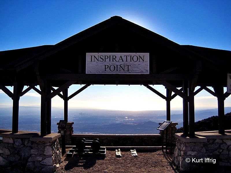
It was nice and cool at that time, and when the wind picked up it was actually cold - in fact the wind blew hard enough that I looked around for low flying aircraft but realized it was just the brush and trees blowing around. I stopped at one point to put on my windbreaker and gloves, which of course made things hot when the wind wasn't howling. I didn't hang around much at Echo Mountain and just headed up the Castle Canyon trail toward Inspiration Point. I've only been on this trail once before and forgot that since it's buried in the canyon the actual objective is out of sight until it's almost in reach, so I just kept moving uphill and occasionally catching a glimpse of the Pasadena area below. Only a tiny bit of water crossed the trail, it looks like three different places might be wet at times but only the lowest spot had any flow. Once I reached Inspiration Point I happily took a food break and also removed my outer shirt to dry off, the back always gets wet under my pack. It was cool enough there to use my down puffy, making it worthwhile to lug the 12 ounces along this trip.
Despite a fairly hard deadline to get home, I thought I could visit Muir Peak too - I had read a description mentioning a use trail going off to the right of the old One Man & Mule railway road so I looked for a spot there. I passed one that was faint and went another quarter mile or so but didn't see anything else so I backtracked to that spot. It was so faint I nearly missed it going the other way, but managed to follow something like a track up the side of the hill. I soon realized this couldn't be Muir Peak since I saw that when contouring around this little bump. Since I was up there I went ahead to the little summit, which had some old metal parts sticking out of the ground along with a great view of Muir and all the way to Catalina. Since it was windy again I didn't hang around for too long, heading back mostly the way I came up. For the return to civilization, I walked down to the Sam Merrill trail and used that to get to Echo, where I retraced my steps from earlier in the morning.
It turned out to be another great day in the mountains, nice to be able to do this stuff in January.....
Pics-
Trailhead at 7:45
Railroad remnants
Sign of progress on Castle Canyon trail
First view of Inspiration Point
It was barely clear enough to use the viewing tubes
Looking down at Inspiration Point from my high point
Return route - First time I saw this sign was on our group hike so I decided to visit sometime
I was going to ask who Sam Merrill was but this answered my questions
AllTrails data, I think the length was a bit shorter - my RunKeeper app clocked it at about 10.9 miles
Inspiration in 2019
-
JeffH

- Posts: 1349
- Joined: Sun Nov 28, 2010 7:09 am
You do not have the required permissions to view the files attached to this post.
"Argue for your limitations and sure enough they're yours".
Donald Shimoda
Donald Shimoda
-
JeffH
- Posts: 1349
- Joined: Sun Nov 28, 2010 7:09 am
Looking around at CalTopo I see that my high point actually has a name. Now to add into my hike log that I conquered Point 4668.

"Argue for your limitations and sure enough they're yours".
Donald Shimoda
Donald Shimoda
-
dima

- Posts: 1735
- Joined: Wed Feb 12, 2014 1:35 am
- Location: Los Angeles
Nice trip! You should explore that area more. It's FULL of various routes, with just a handful being overrun by humans. And according to some USGS maps, you summitted Muir Peak: somebody got point 4688 confused for point 4668 
-
Girl Hiker

- Posts: 1445
- Joined: Fri Apr 04, 2014 7:46 am
Nice report. I should take you on one of my favorite routes I hike around the back country of Echo Mountain. Sean introduced them to me years ago. I do them quite often. As Dima said there are many routes around Echo Mountain.
-
JeffH
- Posts: 1349
- Joined: Sun Nov 28, 2010 7:09 am
Yes you should.Girl Hiker wrote:Nice report. I should take you on one of my favorite routes I hike around the back country of Echo Mountain.
Long drive for me if they start from Eaton.
"Argue for your limitations and sure enough they're yours".
Donald Shimoda
Donald Shimoda
-
JeffH
- Posts: 1349
- Joined: Sun Nov 28, 2010 7:09 am
And I forgot this pic - cheers everyone!
Macallan Gold in the flask.

Macallan Gold in the flask.
"Argue for your limitations and sure enough they're yours".
Donald Shimoda
Donald Shimoda
-
Sean

- Cucamonga
- Posts: 4249
- Joined: Wed Jul 27, 2011 12:32 pm
Actually, I don't think it has anything to do with 4668. The error was likely introduced by a FS revision on the '95 USGS topo when they replaced Inspiration Point (4714) with Muir Peak (4688). I checked the available Sierra Club filing for Muir Peak in 1991, and it appears correct. So the mistake was not theirs in the original paperwork requesting the new name for 4688. After a recent discovery, I now suspect it was a mix up caused by a couple factors. First, GNIS apparently has Inspiration Point recorded at an elevation of 4688' with coordinates N34° 13' 21" W118° 06' 40".dima wrote: And according to some USGS maps, you summitted Muir Peak: somebody got point 4688 confused for point 4668
Inspiration Point
The coordinates are correct, but the elevation is wrong and precisely matches the elevation of Muir Peak.
Also, the GNIS elevation for Muir Peak is recorded as 4682', which does not match the original filing for Peak 4688.
These errors might help explain why Muir Peak was originally placed on Inspiration Point instead of 4688. It appears that the FS requested revisions based on GNIS elevation data, rather than USGS or coordinate information.
-
Tom Kenney

- Posts: 386
- Joined: Sat Sep 29, 2007 7:51 pm
Beautiful day for that loop!
If you continue east on OM&M (did not know it by that name) a little further, you reach the signed route to the eastern variant of Muir Peak. It shows on your second map.
If you continue east on OM&M (did not know it by that name) a little further, you reach the signed route to the eastern variant of Muir Peak. It shows on your second map.
-
David R
- OG of the SG
- Posts: 629
- Joined: Sun Jun 12, 2011 10:28 pm
The point above Inspiration Point called Muir Peak on that map is considered to be the true Inspiration Point as the Pavilion is a low point. There used to be a sign in can up there with confusing sign ins with some calling it Muir and some calling it Inspiration. Muir is the easternmost point and Point 4,668 is just Point 4,668. To add more annoyance the end of the fire road right below Muir is known as Panorama Point which seems rather random.
-
JeffH
- Posts: 1349
- Joined: Sun Nov 28, 2010 7:09 am
So is IP higher than Muir? Both it and the little peaklet I climbed - may be 4688 - are higher than the structure at the saddle. Maybe David has it correct and IP would be a higher point while the observation deck was lower.Sean wrote:Actually, I don't think it has anything to do with 4668. The error was likely introduced by a FS revision on the '95 USGS topo when they replaced Inspiration Point (4714) with Muir Peak (4688.dima wrote: And according to some USGS maps, you summitted Muir Peak: somebody got point 4688 confused for point 4668
Whatever I did, it was fun to be up there and one of these days I'll go up the other peak so I can definitively say that I climbed Muir Peak.
"Argue for your limitations and sure enough they're yours".
Donald Shimoda
Donald Shimoda
-
Sean
- Cucamonga
- Posts: 4249
- Joined: Wed Jul 27, 2011 12:32 pm
You climbed 4668, just south of the ramada. Historical Inspiration Point is just North of the ramada. And Muir Peak is the third bump south of the ramada, immediately above Panorama Point. You need to keep walking down the road a ways until you see an obvious singletrack on the right which is well-maintained. It goes up to Muir.
-
Sean
- Cucamonga
- Posts: 4249
- Joined: Wed Jul 27, 2011 12:32 pm
Incidentally the USGS has fixed the error on the 2015 map. Unfortunately it's still a shitty digital map that sites like CalTopo apparently don't want to use. So the error persists elsewhere.
https://viewer.nationalmap.gov/advanced-viewer/
https://viewer.nationalmap.gov/advanced-viewer/
You do not have the required permissions to view the files attached to this post.
-
CrazyHermit

- Posts: 343
- Joined: Mon Sep 07, 2015 1:03 pm
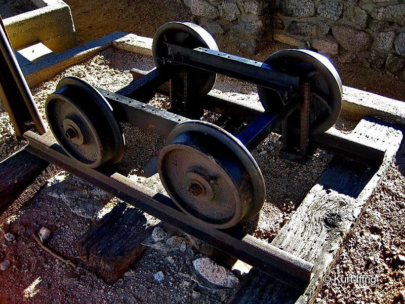
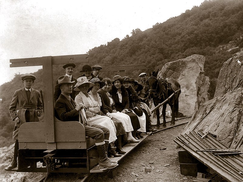
Great report. That's one of the nicest hikes in the San Gabriels. There used to be a tiny railroad that ran from Inspiration Point to Panorama Point called the OM&M Railway (One Man & Mule). Herbert the Mule used to pull the open air train, but they fed him leftover garbage from the Alpine Tavern and he farted so much they had to change the setup to where he pushed the train instead. Sometimes he'd run away, and the owner had to retrofit an old Model T to fit on the track and pull the train. The wheels you see below were part of the original train (found in front of Inspiration Point). There's also another set up at Henninger Flats.
Here's a photo of Herbert pushing the train. The railway operated from 1914 to 1935.
If you go up there near sunset the view is incredible, but you'll have to walk back partially in the dark.
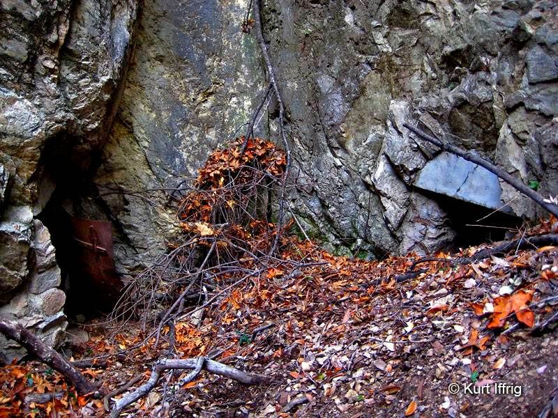
There's also some old gold prospects along the way. This one you can see from the trail if you know where to look.
Here's a couple more, nicknamed the Twin Castle Mines. These ones are down in the Castle Canyon and might be old water tunnels.
Here's a photo of Herbert pushing the train. The railway operated from 1914 to 1935.
If you go up there near sunset the view is incredible, but you'll have to walk back partially in the dark.
There's also some old gold prospects along the way. This one you can see from the trail if you know where to look.
Here's a couple more, nicknamed the Twin Castle Mines. These ones are down in the Castle Canyon and might be old water tunnels.
-
headsizeburrito

- Posts: 279
- Joined: Wed Nov 15, 2017 1:18 pm
I love history!Herbert the Mule used to pull the open air train, but they fed him leftover garbage from the Alpine Tavern and he farted so much they had to change the setup to where he pushed the train instead.
-
CrazyHermit
- Posts: 343
- Joined: Mon Sep 07, 2015 1:03 pm
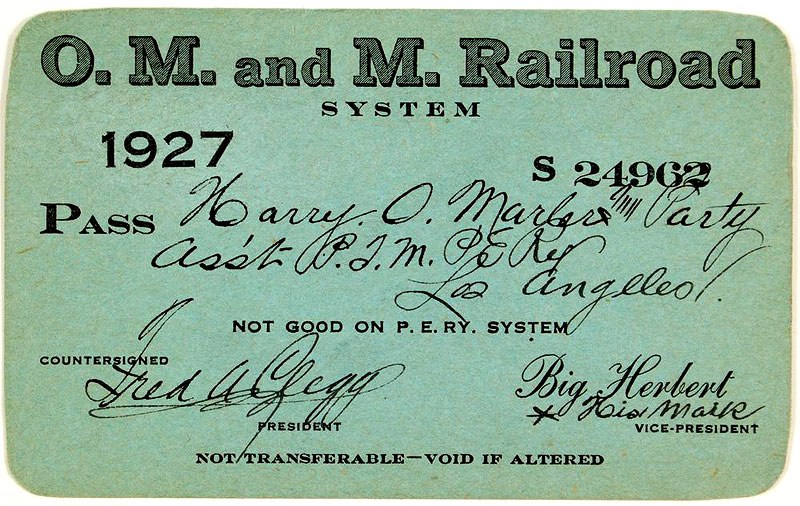
Notice the name of the Vice President on this train ticket.
-
Girl Hiker
- Posts: 1445
- Joined: Fri Apr 04, 2014 7:46 am
-
JeffH
- Posts: 1349
- Joined: Sun Nov 28, 2010 7:09 am
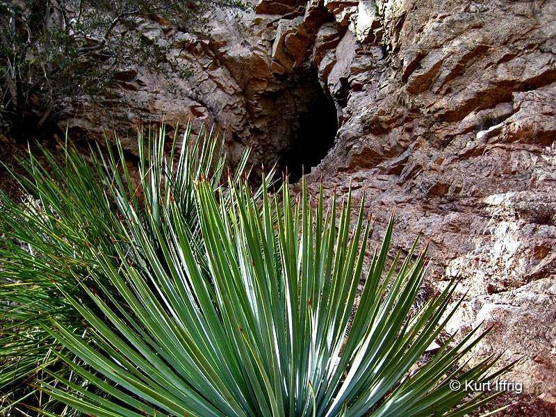
I saw this in Castle Canyon.


"Argue for your limitations and sure enough they're yours".
Donald Shimoda
Donald Shimoda
-
HikeUp

- Posts: 4036
- Joined: Thu Sep 27, 2007 9:21 pm
That hole in the wall is only a few feet deep if I recall. It's an easy scramble up from the trail at a point just down hill of where it crosses the creek I think.
You do not have the required permissions to view the files attached to this post.
-
CrazyHermit
- Posts: 343
- Joined: Mon Sep 07, 2015 1:03 pm
I nicknamed that one the Inspiration mine. It only goes in about 8 feet.
-
ReFreshing

- Posts: 68
- Joined: Mon Nov 26, 2018 1:00 pm
Been up to the little peaks around Inspiration. 4668 is kind of annoying to get to because there is some bushwhacking involved through some prickly stuff. Muir peak is beautiful and has a little wood post to denote the summit..
I made a little post about my trip here:
I made a little post about my trip here: