Will Thrall Pk (7845'), Pleasant View Ridge (7983')

TRs for the San Gabriel Mountains.
Post Reply
User avatar
Hikin_Jim
Posts: 4686
Joined: Thu Sep 27, 2007 9:04 pm

Post by Hikin_Jim »

On Saturday, 7/12/2008, I and cohorts Will and Adam climbed Will Thrall Pk (7845') and the western high point of Pleasant View Ridge (7983') with a quick pre-summit bivvy Friday, 7/11/2008, at "Confluence Camp" in Cooper Canyon near the confluence with Buckhorn Creek.

We started Friday after work at the Buckhorn Campground trailhead of the Burkhart Trail ("A"). http://mapper.acme.com/?ll=34.36845,-11 ... tains%20CA We proceeded about a mile and a quarter to a lovely streamside camping area near the confluence of Cooper Canyon and Buckhorn Creek ("B"). This isn't an official trail camp, but it's a beautiful sylvan spot with reliable year round water in both creeks. The spot is big enough for a larger group of people (twelve?). The three of us had it to ourselves. Look for a large fallen cedar log crossing Cooper Canyon Creek. The log leads directly to the camp site. If you get to the jct with the PCT you've got ~0.1 miles too far.

The mosquitos were fierce this year. There were no signs of bears, but we used the "triangle" anti-bear technique none-the-less (cook in one spot, sleep in another spot, store food in a third spot, all in triangular shape about 100yds apart). There's a lot of duff on the forest floor which makes for comfortable sleeping but sticks pose a hazard to your gear. One minor Thermarest puncture occured.

Saturday, we awoke with the dawn, stashed our overnight gear, and off we went. We soon passed the jct with the PCT and then lovely Cooper Canyon Falls. If you haven't visited the falls, they're worth a look even though the flow isn't particularly voluminous. Thereafter, we crossed Little Rock Creek, ascended the opposite bank and came to the junction of the Burkhart and Rattlesnake Trails ("C").

To the right (east) is the Rattlesnake Trail which would normally be the route of the PCT, but this section of the trail is closed in order to preserve an endangered frog's habitat. However, there was no sign posting said closure at this junction. There was a sign at the traihead in Buckhorn CG. There were the remains of a sign at the Buckhorn/Cooper Canyon jct, but the actual closure notice had been torn from the sign. This closure is however immaterial for Thrall and PVR inasmuch as one proceeds straight (north) and remains on the Burkhart Trail.

As the Burkhart Trail pulls away from the heavily travelled PCT and the popular Cooper Canyon Falls area, one enters territory far less visited. The trail is well constructed and well graded, but is clearly not as often used. The trail contours along the west side of the major south trending ridge that descends from a point on Pleasant View Ridge between Pallett Mtn and Mt. Williamson; this major south trending ridge is the ridge that contains Goodykoontz Pk (7558'). The trail is in generally good condition, but in many spots the trail traverses across scree. In several of these traverses, the trail is a bit loose. None of these loose spots is particularly hazardous although they may be a bit disconcerting to the novice hiker. In one spot, the trail was completely buried in scree. There wasn't even so much as an indentation where the trail had been. Fortunately, the angle of the slope here isn't excessive, and retaining structures above and below the trail exist making navigation of this short stretch of trail eminently doable.

Periodically, the USFS has placed large 4" x 4" wooden mileage posts in the ground tracking the mileage from the Buckhorn Campground trailhead of the Burkhart Trail. Shortly after milepost 3, a small side stream crosses the trail ("D"). This stream was flowing and had filterable amounts of water although given the location filtering would hardly be necessary. Shortly thereafter, the trail crosses a major drainage ("E"). There was a good flow of water here. Between points "D" and "E" there was a small spot suitable for a bivvy downslope (west) of the trail should one be so inclined. The trail then climbs out of the drainage and ascends into a side canyon ("F"). The trail doesn't quite go all the way to the stream bed in the side canyon, but water could be heard coursing down the canyon just below the trail. Point "F" is the last water that we found on the trail this trip.

From the side canyon ("F"), the trail begins it's final climb to Burkhart Saddle, crossing two more drainages ("G" and "H") which were both dry. Finally, one arrives at Burkhart Saddle ("I"). Milepost 5 sits directly in the saddle.

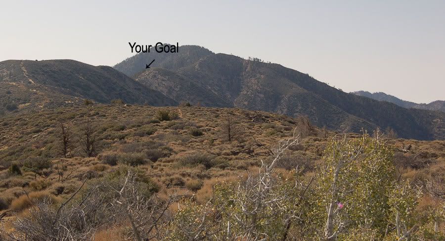
From Burkhart Saddle the route proceeds steeply up the ridge to the west to Thrall Peak. There is a fairly clear use trail. On the topo, a marked trail is shown going south of Thrall Peak from the saddle. We could see traces of the trail, but it did not appear that the trail was still in use, and we opted to use the standard peak bagger's use trail. After perhaps 0.5 miles west of the saddle on the use trail ("J"), the trail begins flatten out a bit. There's a nice spot with a log and some pine needles that would make a good bivvy site here. From "J," the trail proceeds almost due west to Will Thrall Peak ("K"). There are some nice views here of the desert and the Middle High Country, particularly of the Little Rock Creek drainage. We could not find a summit register. There is a commerative plaque honoring naturalist Will Thrall on the summit. Interestingly, just north and west of the summit of Thrall, there is a small bench like area ("N") that seems almost purpose built for camping. This area isn't on route, but it appears to be a natural flat area practically begging someone to spend an evening of star gazing. One of the great things about the entire reach of Pleasant View Ridge is the multitude of secluded spots wherein one could simply stretch out under the stars far removed from the frenetic cares of "civilization" a mere hour's drive away; an opportunity not to be missed.

To the NW of the summit of Thrall Pk, a higher summit can be seen ("M"). This summit is the western high point of Plesant View Ridge. To reach this high point, hereinafter simply referred to as "PVR," simply proceed NW along the ridge to the saddle ("L") between the two summits. Fortunately, one doesn't have to lose a lot of elevation to descend to the saddle. If one stays to the south side of the ridge, the going is generally easier, although use trails are found on both sides of the ridge. From the saddle, there is a trail that proceeds to the NW, staying well south of the crest of the ridge. This trail winds up at a point west of the summit of PVR but is generally easier going than simply following the ridge. Either route however works fine; both are fairly straight forward. From the summit of PVR, good views to the west, particularly of the Mt. Pacifico area, are had as well as views into the desert.

One could easily descend further down Pleasant View Ridge, territory seldom explored if the lack of a use trail is any indicator, but threatening clouds moving in from the east impelled us back to Burkhart Saddle and then to our waiting car.

Pleasant View Ridge, whether the section west of Burkhart Saddle as in this trip or the section east (Pallet Mtn to Mt. Williamson) is a peak bagger's paradise: seldom visited, fine open country, easily navigable with grand vistas in many directions.

Hikin' Jim says: "check it out." :)
User avatar
Tim
Posts: 560
Joined: Tue Apr 08, 2008 8:55 pm

Post by Tim »

Pleasant View Ridge sounds quite pleasant. I wish I could explore more out in that area but it's so far away from the Inland Empire. It's like for you folks in Pasadena who want to go to Vincent Gap but must go all the way around via the 15.
FIGHT ON

Post by FIGHT ON »

I thought you were dead.
User avatar
Hikin_Jim
Posts: 4686
Joined: Thu Sep 27, 2007 9:04 pm

Post by Hikin_Jim »

Rumors of my demise are greatly exaggerated.
FIGHT ON

Post by FIGHT ON »

Hikin_Jim wrote:Rumors of my demise are greatly exaggerated.
I heard no rumors. Thought you was going for a day hike only. Expected a trip report like Sat BUT NO :shock:
FIGHT ON

Post by FIGHT ON »

And those signs at Rattlesnake trail are STILL messed up? They don't care. Pathetic.
User avatar
Hikin_Jim
Posts: 4686
Joined: Thu Sep 27, 2007 9:04 pm

Post by Hikin_Jim »

Oh. Well, I post 'em as soon as I can, but I was in hot enough water already with my wife for spending that much time hiking on Saturday that I couldn't do a TR on Sunday.

I'm hoping to do either Vivian Creek to San G or Momyer Creek to East San B this Saturday. Gearing up for an attempt on the Matterhorn (12279') in the Sierra Nevada on the weekend of 8/2. If not either of those then Twin Peaks from either Three Points or at least Buckhorn.
FIGHT ON

Post by FIGHT ON »

Hikin_Jim wrote:Oh. Well, I post 'em as soon as I can, but I was in hot enough water already with my wife for spending that much time hiking on Saturday that I couldn't do a TR on Sunday.

I'm hoping to do either Vivian Creek to San G or Momyer Creek to East San B this Saturday. Gearing up for an attempt on the Matterhorn (12279') in the Sierra Nevada on the weekend of 8/2. If not either of those then Twin Peaks from either Three Points or at least Buckhorn.
Already in trouble with your wife? :cry: I avoid that by sticking to my plan. Nothing worse than a wife who has good reason to be MAD! :shock:
FIGHT ON

Post by FIGHT ON »

ya you gotta get in shape! Seems like you don't hike much.
User avatar
Hikin_Jim
Posts: 4686
Joined: Thu Sep 27, 2007 9:04 pm

Post by Hikin_Jim »

FIGHT ON wrote:Already in trouble with your wife? :cry: I avoid that by sticking to my plan. Nothing worse than a wife who has good reason to be MAD! :shock:
You've got that right.
FIGHT ON wrote:ya you gotta get in shape! Seems like you don't hike much.
Good one! Now let's see if Michiko buys it... :lol:
User avatar
Kit Fox
Posts: 152
Joined: Tue Dec 25, 2007 11:33 am

Post by Kit Fox »

I've hiked the NW section below "PVR" to visit an aircraft wreck site. My route was "all uphill," but fun nonetheless. I never summited "PVR" because I needed to descend to find the wreck site.

A topo I made that you guys might find interesting.

Image

The crash site photo album below Pleasant View Ridge.

A view from the hike halfway point.

Image
FIGHT ON

Post by FIGHT ON »

Kit Fox wrote:I never summited "PVR"
BECAUSE "The Mountains are the means, the man is the end; the idea is to improve the man, not to reach the top of the mountain." "The Mountains are the means, the man is the end; the idea is to improve the man, not to reach the top of the mountain." "The Mountains are the means, the man is the end; the idea is to improve the man, not to reach the top of the mountain." "The Mountains are the means, the man is the end; the idea is to improve the man, not to reach the top of the mountain." "The Mountains are the means, the man is the end; the idea is to improve the man, not to reach the top of the mountain."
YOU THOUGHT YOU COULD SNEAK THAT BY ME? NO WAY! I'M ALL OVER IT DUDE! :D

and somebody left their phone on a piece of bark painted red and white.
User avatar
Kit Fox
Posts: 152
Joined: Tue Dec 25, 2007 11:33 am

Post by Kit Fox »

That wasn't a cell phone, that was my old gps.

You're right the idea was to improve the man, not to reach the top of the mountain.

Here is a new quote to ponder.

Times of great calamity and confusion have been productive for the greatest minds. The purest ore is produced from the hottest furnace. The brightest thunderbolt is elicited from the darkest storm.

-Charles Caleb Colton

"Don't tell me the sky's the limit when there are foosteps on the moon."
Anon
User avatar
Hikin_Jim
Posts: 4686
Joined: Thu Sep 27, 2007 9:04 pm

Post by Hikin_Jim »

Interesting route! The ridge actually looks like a good avenue up into that area. How was the XC travel? The ridge looks a little rougher once you get past point 7025 ("P") but otherwise not bad. Getting down to the wreck in the vicinity of point "O" looks gnarly.

http://mapper.acme.com/?ll=34.39459,-11 ... %2Cunnamed

I'm curious why you decided to hike up the ridge from the west instead of using the Burkhart Trail and going west along the ridge from Burkhart Saddle. It seems like it would have been quicker and easier to take the trail in from Devil's Punchbowl. Or maybe you just really really like XC travel? :)

Out of curiousity, were you able to drive up the "Alimony Truck Trail" ("Q")?

HJ
User avatar
Kit Fox
Posts: 152
Joined: Tue Dec 25, 2007 11:33 am

Post by Kit Fox »

Hikin_Jim wrote:Interesting route! The ridge actually looks like a good avenue up into that area. How was the XC travel? The ridge looks a little rougher once you get past point 7025 ("P") but otherwise not bad. Getting down to the wreck in the vicinity of point "O" looks gnarly.


I'm curious why you decided to hike up the ridge from the west instead of using the Burkhart Trail and going west along the ridge from Burkhart Saddle. It seems like it would have been quicker and easier to take the trail in from Devil's Punchbowl. Or maybe you just really really like XC travel? :)

Out of curiousity, were you able to drive up the "Alimony Truck Trail" ("Q")?

HJ
I chose that ridge is because the Burkhart trail from Devil's Punchbowl is a longer hike with about 2000 feet more elevation gain.

The alimony trail is gated at a bit West of my parking spot. This is courtesy of that stupid toad closure, from the 90s.
User avatar
Hikin_Jim
Posts: 4686
Joined: Thu Sep 27, 2007 9:04 pm

Post by Hikin_Jim »

Kit Fox wrote:The alimony trail is gated at a bit West of my parking spot. This is courtesy of that stupid toad closure, from the 90s.
But you were able to get to the area you mark as "starting point," yes? Starting there is a signficant elevation advantage, and you don't have to go up and over Thrall and PVR. That makes sense.

Yes, the Burkhart Trail is a lot longer now, particularly since they shut down the original Carothers Creek trailhead. I wish the USFS would do a little to protect public rights of way instead of doing things like putting in a 4 mile (round trip) detour. At least I think it's 4 miles; my memory may not be correct.

It looks like one might be able to park at or near your "extraction point" which I've marked as "T" and proceed south up the drainage ("U"), then up the ridge marked "V" and gain the Burkhart Trail at point "W." I'm just looking at the topo; so I have no idea about fences or brush. It sure would be nice not to have to go all the way to Devil's Punchbowl in order to get to the trailhead.

http://mapper.acme.com/?ll=34.42135,-11 ... ossom%20CA
User avatar
Kit Fox
Posts: 152
Joined: Tue Dec 25, 2007 11:33 am

Post by Kit Fox »

Hikin_Jim wrote:
Kit Fox wrote:The alimony trail is gated at a bit West of my parking spot. This is courtesy of that stupid toad closure, from the 90s.
But you were able to get to the area you mark as "starting point," yes? Starting there is a signficant elevation advantage, and you don't have to go up and over Thrall and PVR. That makes sense.

Yes, the Burkhart Trail is a lot longer now, particularly since they shut down the original Carothers Creek trailhead. I wish the USFS would do a little to protect public rights of way instead of doing things like putting in a 4 mile (round trip) detour. At least I think it's 4 miles; my memory may not be correct.

It looks like one might be able to park at or near your "extraction point" which I've marked as "T" and proceed south up the drainage ("U"), then up the ridge marked "V" and gain the Burkhart Trail at point "W." I'm just looking at the topo; so I have no idea about fences or brush. It sure would be nice not to have to go all the way to Devil's Punchbowl in order to get to the trailhead.

http://mapper.acme.com/?ll=34.42135,-11 ... ossom%20CA
Believe me, you don't want to start at the extraction point. The only reason I chose that route was because I had a cell phone signal, and I was able to call my wife. The last 1/2 mile is actually posted but vacant private property. The property is only marked where my wife picked me up.

That descent was nothing but a brush and alder tree choked canyon. I opted to avoid he creek bottom because I forgot to bring a chainsaw and machete. I had to kick my way through brush on a loose hillside for over a mile and a half. The other downside about the river bottom was all the Black Bear tracks and scat that I encountered.


My parking spot was a bit steep to get too, but my front wheel drive car managed ok. This route is steep, very steep, but I perservered. The view of the AV was nice from this route.
FIGHT ON

Post by FIGHT ON »

Kit Fox wrote:
Hikin_Jim wrote:
Kit Fox wrote:The alimony trail is gated at a bit West of my parking spot. This is courtesy of that stupid toad closure, from the 90s.
But you were able to get to the area you mark as "starting point," yes? Starting there is a signficant elevation advantage, and you don't have to go up and over Thrall and PVR. That makes sense.

Yes, the Burkhart Trail is a lot longer now, particularly since they shut down the original Carothers Creek trailhead. I wish the USFS would do a little to protect public rights of way instead of doing things like putting in a 4 mile (round trip) detour. At least I think it's 4 miles; my memory may not be correct.

It looks like one might be able to park at or near your "extraction point" which I've marked as "T" and proceed south up the drainage ("U"), then up the ridge marked "V" and gain the Burkhart Trail at point "W." I'm just looking at the topo; so I have no idea about fences or brush. It sure would be nice not to have to go all the way to Devil's Punchbowl in order to get to the trailhead.

http://mapper.acme.com/?ll=34.42135,-11 ... ossom%20CA
Believe me, you don't want to start at the extraction point. The only reason I chose that route was because I had a cell phone signal, and I was able to call my wife. The last 1/2 mile is actually posted but vacant private property. The property is only marked where my wife picked me up.

That descent was nothing but a brush and alder tree choked canyon. I opted to avoid he creek bottom because I forgot to bring a chainsaw and machete. I had to kick my way through brush on a loose hillside for over a mile and a half. The other downside about the river bottom was all the Black Bear tracks and scat that I encountered.


My parking spot was a bit steep to get too, but my front wheel drive car managed ok. This route is steep, very steep, but I perservered. The view of the AV was nice from this route.
Jim. Notice how many times this guy mentions his wife! :D cell phone contact etc! HEEP BIG DIFFERENCE WHEN HE GOT HOME I BETCHA!! :D :D :D :D HERTZ? SHE PICKED HIM UP!!!!!!!!!!!!!!!!!!!!!!!!!!!!
User avatar
Kit Fox
Posts: 152
Joined: Tue Dec 25, 2007 11:33 am

Post by Kit Fox »

She didn't mind picking me up.

I got lazy and didn't want to scale that damn scree slope again. After doing that brush filled gulley, I think i'd rather upclimbed instead.
User avatar
Hikin_Jim
Posts: 4686
Joined: Thu Sep 27, 2007 9:04 pm

Post by Hikin_Jim »

Kit Fox wrote:
Hikin_Jim wrote:
Kit Fox wrote:The alimony trail is gated at a bit West of my parking spot. This is courtesy of that stupid toad closure, from the 90s.
But you were able to get to the area you mark as "starting point," yes? Starting there is a signficant elevation advantage, and you don't have to go up and over Thrall and PVR. That makes sense.

Yes, the Burkhart Trail is a lot longer now, particularly since they shut down the original Carothers Creek trailhead. I wish the USFS would do a little to protect public rights of way instead of doing things like putting in a 4 mile (round trip) detour. At least I think it's 4 miles; my memory may not be correct.

It looks like one might be able to park at or near your "extraction point" which I've marked as "T" and proceed south up the drainage ("U"), then up the ridge marked "V" and gain the Burkhart Trail at point "W." I'm just looking at the topo; so I have no idea about fences or brush. It sure would be nice not to have to go all the way to Devil's Punchbowl in order to get to the trailhead.

http://mapper.acme.com/?ll=34.42135,-11 ... ossom%20CA
Believe me, you don't want to start at the extraction point. The only reason I chose that route was because I had a cell phone signal, and I was able to call my wife. The last 1/2 mile is actually posted but vacant private property. The property is only marked where my wife picked me up.

That descent was nothing but a brush and alder tree choked canyon. I opted to avoid he creek bottom because I forgot to bring a chainsaw and machete. I had to kick my way through brush on a loose hillside for over a mile and a half. The other downside about the river bottom was all the Black Bear tracks and scat that I encountered.

My parking spot was a bit steep to get too, but my front wheel drive car managed ok. This route is steep, very steep, but I perservered. The view of the AV was nice from this route.
What I was actually driving at was not to get up to the wreck site -- I fully believe that the drainage you descended would have been a huge PITA -- but rather to get from your extraction point to the Burkhart Trail. Take a look at the map link I posted. Point "W" is an obvious place to pick up the trail without the huge waste of having to pick up the trail 4 miles* to the east in Devil's Punchbowl Co. Park. Plane wrecks are very cool, but in this case I was just speculating how to get reasonable access to the Burkhart trail.

HJ

*I said 4 miles round trip originally (based on memory). If what I've read subsequently is correct, it's 4 miles each way :shock: extra now that the original trailhead is closed.
User avatar
AW~
Posts: 2040
Joined: Mon Oct 01, 2007 12:00 pm

Post by AW~ »

Thanks for the info on the wreckage site...curiously enough...
"07/14/2008 13:21 ANF-2486 Remnants of a Crash Site Miscellaneous Near Pleasant View Ridge 34,23.22 x 117, 52.05 "
Post Reply