
As of 19 Apr 2013 the east closure was at the gate immediately west of Vincent Gap, so you could approach from the Wrightwood side and park at V. Gap. We went north to Pinyon Ridge, but the folks parked next to us in the lot said the didn't quite get to the top of Baden-Powell due to snow. Said it was probably do-able, but they opted out due to the clothing & shoes they had on.
The typical winter closure is actually stated as from Islip Saddle to 5 mi west of Big Pines according to http://dot.ca.gov .... "5 mi west of Big Pines" being Caltrans-speak for Vincent Gap for some reason.
Note: The DOT website sometimes doesn't get the message right away when the road is open or closed.
Vincent Gap Trail (Mt. Baden-Powell)
-
Beantown
- Posts: 45
- Joined: Wed Mar 21, 2012 9:06 am
Went up Baden Powell today from islip saddle th, pretty much snow free except for a few small patches left.
-
oldcoot
- Posts: 64
- Joined: Wed Jun 16, 2010 9:42 pm
Too late for original poster, but in case anyone's interested, drove Hwy 2 from the 210 to Vincent Gap Friday and climbed all the switchbacks to Baden-Powell...road was open and in great shape, and trail had just one small patch of snow, about midway between MM3 and the top, easily bypassed...
-
HikeUp

- Posts: 4036
- Joined: Thu Sep 27, 2007 9:21 pm
Great update coot. Thanks!oldcoot wrote: Too late for original poster, but in case anyone's interested, drove Hwy 2 from the 210 to Vincent Gap Friday and climbed all the switchbacks to Baden-Powell...road was open and in great shape, and trail had just one small patch of snow, about midway between MM3 and the top, easily bypassed...
-
shreddy

- Posts: 241
- Joined: Sun Jan 16, 2011 10:40 pm
The short post just after Lamel Springs says 2. Is this accurate?
Thanks!
Thanks!
-
mattmaxon

- Posts: 1137
- Joined: Mon Mar 24, 2008 12:48 pm
-
tekewin

- Posts: 1385
- Joined: Thu Apr 11, 2013 5:07 pm
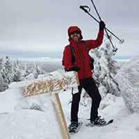
I went up to Baden-Powell and friends yesterday.
The north face is still holding a lot of snow but the trail is mostly clear. I ran into about a dozen snow/ice patches covering the trail. They get slippery after they have melted a little in late morning. It was very cold in the early AM. Ridgelines to Burnham and Throop are clear.

Typical snow patch on the trail

North face of Baden-Powell
TR if you want to see more photos:
http://ironhiker.blogspot.com/2013/10/m ... -peak.html
-
mrnizegy
- Posts: 37
- Joined: Tue Dec 18, 2012 3:02 pm
I'm planning on hitting Baden-Powell this Saturday. If anyone has some first-hand info on current conditions, please let me know. The latest I'm aware of is mostly based on the video from the recent rescue due to the older man who slipped on the ice and had to be rescued.
Very curious about the ridge and peak due to the recent heat wave, and then the rains from yesterday and today.
I'll of course have Snowshoes, Microspikes, Crampons and Ice Axe to be used as needed.
Hope to see you on the trail!
–––––– UPDATE–––––
Hiked the area, first half mile or so is clear with a few patches of ice, becoming more frequent until hard packed ice and snow the rest of the way. See my TR.
-
Sean

- Cucamonga
- Posts: 4251
- Joined: Wed Jul 27, 2011 12:32 pm
As of Feb. 18, little snow and ice on most of the trail. Microspikes recommended for last mile before the summit, but doable without.