This is a hike that Hikin Jim had described to me on the Wrightwood forum site. In his description he had mentioned that it should not be attempted alone. I now can certainly see why.
We arrived at the mine at around 9:30 after hiking in from Vincent Gap. We stood at the edge of the Mine gazing down at the steep scree field which comprised the descent. After mustering up some courage, down we went. My dog Violet looked at me more than once with a "What the heck did you get us into" look on her face, but after 45 minutes of bumblin' and stumblin' we made it down to the main section of Mine Gulch, and much easier traveling. The trip down was worth it if only for the cool old mine cars we passed along the route. 8) I must say, I agree with Jim in that this route should not be attempted alone. (If I'd have broken a leg or worse I'd have pretty much been screwed) Lesson learned.
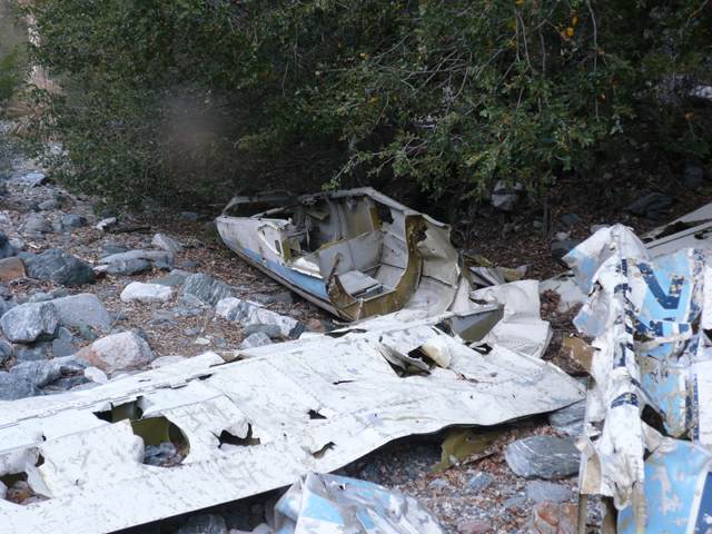
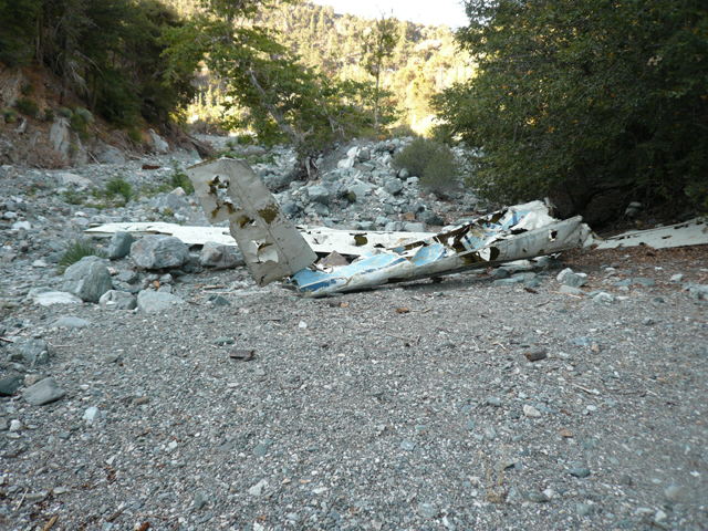
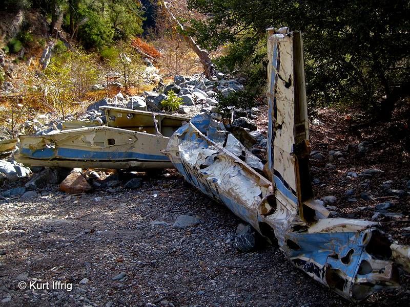
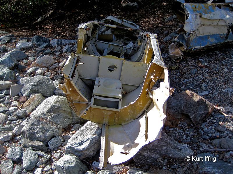
After reaching Praire fork I made the left turn at Vincent Gulch, and was searching for the Vincent trail when I stumbled upon an old plane wreck.
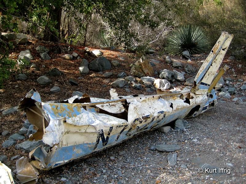
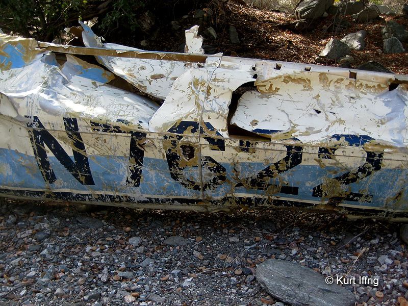
Anyone know the history of this one? Looks like an old Cessna or something.
Reached the Vincent Gap parking area around 13:30 a welcome site! Even the dog was whooped. http://www.flickr.com/photos/30922174@N ... 103350983/
Very cool hike. Good country over there. All the old mining equipment below the mine is one of the the most interesting parts of the hike.
You started at 9:30 and got back to your car at 1:30?! Wow! Only 4 hours?! You were moving. Did you drink like 10 cups of coffee or something?
HJ
Actually, I got to the mine at 9:30. I left Vincent gap around 8:30. I did have a grande cup of Starbucks though! 8) (Thanks Taco)
Thanks for the info Jim.
Did you see that plane when you came up Vincent? Judging from the graffiti on it, It preceeded 1994.
Five hours? That's still pretty impressive. Must be that good Wrightwood acclimitazation.
I don't recall seeing that aircraft the last time I was there. That was in Vincent Gulch? You'd think I'd have seen that, but Vincent Gulch is pretty wide at the mouth with a lot of little tree covered hillocks that tend to compartmentalize what you can see.
Hikin_Jim wrote:Five hours? That's still pretty impressive. Must be that good Wrightwood acclimitazation.
I don't recall seeing that aircraft the last time I was there. That was in Vincent Gulch? You'd think I'd have seen that, but Vincent Gulch is pretty wide at the mouth with a lot of little tree covered hillocks that tend to compartmentalize what you can see.
Yeah, I was almost on top of it before I realized what it was. It was on the south side of Vincent gulch under a large scrub oak tree, not too far from the intersection with Praire fork. I marked it with my GPS. Here are the coordinates N3420.824 W11743.551.
As for the speed of it, I was fueled a little more by anxiety, than acclimitazation although living at a higher elevation helps. I think because I was'nt sure how long it would take, I quickened my pace a bit.
Maybe a little less enjoyable for that reason.
Bill wrote:
After reaching Praire fork I made the left turn at Vincent Gulch, and was searching for the Vincent trail when I stumbled upon an old plane wreck.
Anyone know the history of this one? Looks like an old Cessna or something./
Did you get any other photos... GPS data etc?
Part numbers registration number etc... would be helpful
The only one I know of out that way is a Helo, it was salvaged with just a few parts remaining Rotor blades I was told....
My AFRCC database shows a N2180N Cessna 140 crashed 1/23/1983
I'm no expert, but it looks like a glider to me. A great place to post a question about the plane is www.wreckchasing.com (then visit the discussion board.)
AW wrote:where is that graffiti at? thats ridiculous(what graffiti isnt but...)...anyways..nice country..thanks.....
Yeah, I agree. Graffiti was scratched on the tail section. I think because of curiosity and just an excuse to go hiking, I'll head down there and investigate further. Maybe get some kind of identifying numbers or markings. 8)
I'm no expert and I'm not a "wreck chaser", but I can say that this wreckage has been there for a pretty long time. I first came upon it sometime around 1988, but friends told me it was there long before that. I always stop by to look at it when I'm in this area but I've never analyzed it for identifying markings. I thought it was a glider, perhaps one from the glider place at Crystalaire. Maybe they would have more info about it.
Side note: If you ever get a chance, take one of those glider rides. I took my wife for her birthday one year and the view you get of the region is incredible (including buzzing the people standing on the top of Baden). It's quite a rush.
Ditto on the glider thing. I took a lesson a few years ago. It is a major rush. When you heel that baby over, there ain't nothin' 'tween you and the ground. The cockpit glass extends down to about your hips. When you're really banked, it is freaky.
Hikin_Jim wrote:Ditto on the glider thing. I took a lesson a few years ago. It is a major rush. When you heel that baby over, there ain't nothin' 'tween you and the ground. The cockpit glass extends down to about your hips. When you're really banked, it is freaky.
Looks like fun! Hopefully if I do go, I won't get in with a guy that only "stayed in a Holiday Inn Express last night" like the guy at the bottome of Vincent gap did!
Kit Fox wrote:I'm no expert, but it looks like a glider to me. A great place to post a question about the plane is www.wreckchasing.com (then visit the discussion board.)
Thanks for the tip! I posted an inquiry about the wreck, and general consenses seems to indicate it is a glider a Schweizer 2-32.
Hi, I'm wondering if anyone knows about how far down the scree slope (from the mine) those mine carts are located. We're considering doing that route dropping from the mine to the river to the glider wreck and back up to Vincent Gap but might take a slightly alternate route down but don't want to miss the carts.
It's a Mooney M20. I was just there. And in my previous life a pilot and mechanic....
I did some quick research on some sites i kno, but interestingly found no info.
Earliest "graffiti" date inscribed I found was 1977. Anyone find more info, please elaborate.
No one ever replied to my posting so I finally had to get another courageous hiker to do the Mine Gulch loop hike with me. Found at least 2 possibly 4 mine carts very far down the scree slope from the mine. It is 1600' decent in 0.8 miles (about 2000'/mile) and very dangerous most of the way (25' dry waterfall; rusty nails; splinters; very unstable scree; hidden soft spots). NEVER attempt alone. I had a hiking partner, GPS, bear spray, and a reliable PLB. Whole trip took 6 hours and was a tough 8.4 miles.
The No.5 entrance is easy to find along the "hidden" rim trail but it is sealed. If you continue past it along the rim trail for about a mile, you'll come to a spot where the trail has fallen away and someone tied a rope to a strong bush and presumably repelled down... to what I don't know. We weren't about to trust a rope that we didn't bring.
The wreckage down in the gulch is a sailplane that crashed in February of 1974. Both people survived the crash.
It is 1600' decent in 0.8 miles (about 2000'/mile) and very dangerous most of the way (25' dry waterfall; rusty nails; splinters; very unstable scree; hidden soft spots). NEVER attempt alone.
That probably explains why no one could answer your question.
Fantastic find Bill. The mine at the bottom is called the Fenner Tunnel, part of the Bighorn family. It's a two level mine that only operated for about a year and is heavily shored up on the inside with some very dangerous cave ins. Someone dragged a tall ladder inside to get to the second level, although I've never seen pictures of it.
Here's a little background on that plane wreck. Yes, it was a glider or sail plane. It crashed on 2/6/74. The flight came out of Llano, California. The plane is a Schweizer SGS 2-32 N7622. James Webb and his passenger Harry Diltiz were soaring in high winds near Mt. Baden Powell and flew into a violent downdraft. The pilot attempted to land in the wash when the plane hit trees on the final approach. Although the plane was totally destroyed, both the passenger and pilot walked away with only minor injuries. Truly amazing.
There's a great website by a guy named Joe Idoni who has successfully found dozens of these wrecks, highly recommended ,,,
Fun fact: Henry Diltz is a photography who took a number of famous photos of rock musicians from the 60s and 70s and Jimmy Webb is an accomplished songwriter. According to Wikipedia, Diltz was filming when they crashed but the film didn't survive...