Impromptu Akawie to Winston Traverse

TRs for the San Gabriel Mountains.
Post Reply
User avatar
Sean
Cucamonga
Posts: 3792
Joined: Wed Jul 27, 2011 12:32 pm

Post by Sean »

You can always change your mind, but not your footwear.

Image

Cecelia was going to take the day off. But when she heard me preparing for a hike, she decided to come along and keep an eye on her man. I had no particular plan. Usually that means I drive up the Angeles Crest and await inspiration. And that was indeed the case this time.

Shortly after leaving La Canada we bumped up against a large caravan of slow-moving Volkswagens. They controlled the flow of traffic until Chilao, where, I guess, they intended to have an outdoor convention.

Image

Continuing along Cecelia suggested doing something around Buckhorn--always a great area to spend a day. Plus, she hadn't summited Mt. Akawie, so that became the plan.

Akawie is pretty easy (0.8 miles one-way with 420' of gain), so I packed light and wore my hiking sandals. It's a Sierra Club peak, which means I don't need to bother with approach details.

The top contained a bunch of boulders. We could see where a benchmark had once been.

Image

The missing mark disappointed Cecelia. I tried to cheer her up by finding a neat rock formation, which we dubbed Potato Chip Crumb Rock.

Image

On the way back I looked across the canyon toward Winston Peak and felt an idea pop into my mind.

Image

I had never done the cross-country traverse between Akawie and Winston (2.1 miles with 1100' of gain). Looking at the topo map, the route seemed okay. Nothing horrible. The only problem was that I had left my boots in the car. Oh well, the sandals would have to suffice.

Image

We hit some steep sections and did the old pine needle shuffle, trying not to slip and fall on our butts while dropping about 900' of elevation. Eventually we made the bottom of upper Cooper Canyon. A little water still pooled and trickled in the creek bed. Utilizing deer paths we escaped up the opposite bank and hit the Pacific Crest Trail.

Image
(Looking back at our descent route from Akawie.)

From the PCT we found an easy way to access the east ridge of Winston Peak.

Image
(XC traverse route in red.)

The east ridge was great, with a nice mix of moderate to steep grades. We enjoyed some shade under big trees and among periodic boulder fields.

Image

I took note of an impressive cloud formation to the north, which later that evening turned into a powerful thunderstorm that crossed the high desert.

Image

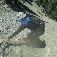
By the time we reached Winston Peak, my feet had taken a small amount of abuse. Rocks, sand, and twigs routinely fought their way into my ill-considered footwear and caused quite a bit of mischief. I spent a good twenty minutes or so with a sharp pebble buried in the bottom of my index toe. Yeah, it hurt, but sometimes you just don't want to bother emptying your sandals for the umpteenth time. One rock in the foot isn't worth the effort. Two, maybe. Three, definitely. This is the law of the hiking sandals.

Image
User avatar
Girl Hiker
Posts: 1341
Joined: Fri Apr 04, 2014 7:46 am

Post by Girl Hiker »

It was a fun hike with beautiful views all around
User avatar
Tom Kenney
Posts: 372
Joined: Sat Sep 29, 2007 7:51 pm

Post by Tom Kenney »

Great pics! Lots of neat stuff up there. As the PCT gets toward Eagle's Roost (Rattlesnake Cyn, IIRC) there are some pretty early-season waterfalls adjacent to the trail.

Here's that thunderstorm, gearing up for the light show:
Image

And some action over Baden-Powell:
Image

And a short vid of the light show, viewed from the Jackson Lake Trail (couldn't figure out how to embed vids, so did a link):
Thunderstorm Over Palmdale (YouTube)
User avatar
tekewin
Posts: 1195
Joined: Thu Apr 11, 2013 5:07 pm

Post by tekewin »

Like! Sometimes the best plans are no plans. Hard to go wrong in that area, unless you run into a Sasquatch den.
User avatar
HikeUp
Posts: 3861
Joined: Thu Sep 27, 2007 9:21 pm

Post by HikeUp »

Winston A. Sasquatch, Esquire.
User avatar
Sean
Cucamonga
Posts: 3792
Joined: Wed Jul 27, 2011 12:32 pm

Post by Sean »


HikeUp wrote:Winston A. Sasquatch, Esquire.
Image

The O.G. Sasquatch.
User avatar
HikeUp
Posts: 3861
Joined: Thu Sep 27, 2007 9:21 pm

Post by HikeUp »

Hmmm...Winston photobombed you.
1.jpg
User avatar
Sean
Cucamonga
Posts: 3792
Joined: Wed Jul 27, 2011 12:32 pm

Post by Sean »


tekewin wrote:Hard to go wrong in that area, unless you run into a Sasquatch den.
I'm always prepared with a bag of Sasquatch cookies--you know, for the kids. The trick to making friends with any legendary beast is: bring snacks for its children.

Image
User avatar
Sean
Cucamonga
Posts: 3792
Joined: Wed Jul 27, 2011 12:32 pm

Post by Sean »

HikeUp wrote:Hmmm...Winston photobombed you.
Image That dude's so funny. Gets me every time!
User avatar
tekewin
Posts: 1195
Joined: Thu Apr 11, 2013 5:07 pm

Post by tekewin »

HikeUp wrote: Hmmm...Winston photobombed you.
I missed that the first time. Scary.
User avatar
Sean
Cucamonga
Posts: 3792
Joined: Wed Jul 27, 2011 12:32 pm

Post by Sean »


Tom Kenney wrote:As the PCT gets toward Eagle's Roost (Rattlesnake Cyn, IIRC) there are some pretty early-season waterfalls adjacent to the trail.
Never been in there because of the closure order. Got any pictures? I've only seen Cooper Canyon Falls in that area. Thanks for the video of the light show. Neat!
User avatar
Tom Kenney
Posts: 372
Joined: Sat Sep 29, 2007 7:51 pm

Post by Tom Kenney »

Sean wrote:
Tom Kenney wrote:As the PCT gets toward Eagle's Roost (Rattlesnake Cyn, IIRC) there are some pretty early-season waterfalls adjacent to the trail.
Never been in there because of the closure order. Got any pictures? I've only seen Cooper Canyon Falls in that area. Thanks for the video of the light show. Neat!
Sorry, no pics. This was nearly 35 years ago, when I did my first long-term hike with BSA. We did east-to-west starting at Vincent Gap. I just recall that the section descending from Eagle's Roost was very scenic. We didn't see any samsquantches, but I smelled something really funky when we got to Cooper Cyn CG!

If you search YouTube for 'thunderstorm palmdale lancaster' there are some better vids of the same storm. I only had my phone cam. It's hard to tell, but there was about twice as much activity as visible in my vid. Lightning going off about every 0.5-2.0 seconds.
User avatar
Girl Hiker
Posts: 1341
Joined: Fri Apr 04, 2014 7:46 am

Post by Girl Hiker »

HikeUp wrote: Hmmm...Winston photobombed you.
haha!! I acturally saw him but didn't tell Sean
User avatar
Uncle Rico
Posts: 1402
Joined: Thu Mar 20, 2008 7:48 pm

Post by Uncle Rico »

Sasquatch is here. Or at least in Fresno. http://kmph.com/news/local/is-bigfoot-b ... the-valley
User avatar
Sean
Cucamonga
Posts: 3792
Joined: Wed Jul 27, 2011 12:32 pm

Post by Sean »


Uncle Rico wrote:Sasquatch is here. Or at least in Fresno. http://kmph.com/news/local/is-bigfoot-b ... the-valley
“The [five Bigfoots] scattered and the one [carrying] the pig was running so fast it didn’t see an irrigation pipe and it tripped, with the pig flying over,” says Gonzalez.
I'll believe in Sasquatch...

Image
User avatar
HikeUp
Posts: 3861
Joined: Thu Sep 27, 2007 9:21 pm

Post by HikeUp »

Doing the Winston!
winston.gif
User avatar
AW~
Posts: 2044
Joined: Mon Oct 01, 2007 12:00 pm

Post by AW~ »

Squatchy does monitor the forum right? With the left behind cell phones and whatnot. I bet it already has iphone 10.
Was that log that displaced hikers at 3 points Squatchy's work or just a coincidence?
The sign to Twin Peaks saddle kept getting knocked down now that I think about it.
Its lasted as far as I know , after I put some rocks to stabilize it...so if the sign is down again, this is not natural :)
Might want to consider turning back if so ;)
Post Reply