New look on Baldy

TRs for the San Gabriel Mountains.
Post Reply
User avatar
JeffH
Posts: 1169
Joined: Sun Nov 28, 2010 7:09 am

Post by JeffH »

I went up on Sunday evening, spent a cold windy night at the summit and walked down on Monday morning. On the way I saw evidence of some trail work, as markers were put up above the ski hut and real signs at the top. Unfortunately they don't point exactly where to go, so I say people are still going to be on the wrong trail at some point.
The annual run to the top is on Labor Day, so I thought it would be cool to be up there for the finish. I was right on the cool part only, I didn't hang around long enough to see any of the runners. I got to the summit just about sunset, with a very cool wind howling and lots of people hunkered down in the rock shelters. Unfortunately there wasn't a good space for me, so I plopped down at a spot barely wide enough to keep the wind off of my back. I sat there for a while shivering, so out came the Jetboil and I heated some water for tea and a white bean chili dinner. That made me feel much better, but trying to set up my tent was a loser idea. I set the narrow foot part next to the rocks, but trying to drape the tent over the frame just turned it into a giant sail. Since I didn't want to chase it down over Harwood, I just left the footprint on the ground and set up my sleeping pad on top. Since I didn't want to sleep downhill, I put my feet into the rock shelter and bundled up inside my bag. First time I've ever slept with my jacket on, but I was actually very comfortable. Every time I woke up I thought I might be able to set up the tent but the wind was moaning all night long so that didn't happen. One of the people up there had a anemometer, he measured the wind at a steady 24 mph with gusts of about 38. Combined with the 40 degree temperature it felt pretty cold.
In the morning we were treated to a great sunrise, as the low elevation clouds topped out at about 5000 feet. Watching it peek over the horizon was definitely worth the cold evening (and morning!). However, the wind never died down and it wasn't fun to just sit bundled up behind some rocks so I headed downhill via the Baldy Bowl trail around 7:45. The race started at 8:00, with the first runners expected a little after 9:00 so I'm glad I didn't wait around.
Lots of hikers on the way asked me if they were on the right trail, along with plenty of folks panting out "how much further?".

Just another great day on Baldy.


Image
Marker on the trail. These go up closer to the edge of the bowl than before, even though all the trails eventually end up at the same place.


Image
Another new marker although with the old sign there this may be unnecessary.


Image
The picture doesn't look anything near as good as it did in person. The fiery orange color along Ontario ridge was fantastic.


Image
Sunset shadow all the way to San Gorgonio.


Image
First glimpse of the sun. According to the iPhone it was 6:21am, it started to get light around 5:40.


Image
New sign at the top. The arrow to the village actually points more toward the Bowl trail.


Image
Another new sign. These are about 30-40 feet apart on the summit. And I think the mileage to Manker campground is more than 3.5.


Image
The summit marker has been cemented and grouted in place a little higher.


Image
Sunrise shadow on the clouds.


Image
Cloud cover as I was walking down.


Image
This marker is at the ridge above the ski hut. It says "Trail" on two sides, no arrows pointing out the direction but this one is obvious.


Image
Seems people don't like signs on this part of the trail. Not like it's a secret anymore.
"Argue for your limitations and sure enough they're yours".
Donald Shimoda
User avatar
HikeUp
Posts: 3855
Joined: Thu Sep 27, 2007 9:21 pm

Post by HikeUp »

Wow. Interesting new signs and grouting of the plaque. Vandalized by Thanksgiving I predict.

Thanks for the pictures!
User avatar
Sean
Cucamonga
Posts: 3782
Joined: Wed Jul 27, 2011 12:32 pm

Post by Sean »

Those signs wth the cutout lettering are going up everywhere now. They seem like a good choice to me. Spray painters couldn't possibly get much satisfaction from tagging the faceplate. The writing would be all broken up. And the metal will be more sturdy than the previous wooden ones.

The metal guide stakes are also helpful, especially in foul weather. People will still get lost, because they have limited or no navigational skills, and apparently cannot follow a well-beaten trail. But in terms of Baldy trails, the Ski Hut is all-around the safest. The FS should improve the Backbone, where it's truly hazardous, even in good weather.
User avatar
SGBob
Posts: 101
Joined: Wed Jan 07, 2015 12:47 pm

Post by SGBob »

Sean wrote: The FS should improve the Backbone, where it's truly hazardous, even in good weather.
As far as I know the Forest Service has not done any work to maintain or improve trails in at least a decade. Almost all trail work you see in the Angeles is accomplished by volunteers with their own tools, time, and signage at their own expense. The Forest Service pays nothing. I believe there have been a couple of trails where the Forest Service hired a contractor to repair them, but that's it.
User avatar
Girl Hiker
Posts: 1330
Joined: Fri Apr 04, 2014 7:46 am

Post by Girl Hiker »

Nice report!. The new signs are great! Unfortunately, hikers still get lost but I suppose if everyone could afford a GPS unit, pay attention to signs, or really study maps like one nerd I know, lol then no one would be lost. However, it does happen to the best of us!

I love the sunrise pics
User avatar
Edward
Posts: 42
Joined: Sat Oct 11, 2014 11:02 am

Post by Edward »

Sean wrote: But in terms of Baldy trails, the Ski Hut is all-around the safest. The FS should improve the Backbone, where it's truly hazardous, even in good weather.
Perhaps. Certainly room for differences of opinion. But it is not the conclusion I drew, on a recent hike where I went up the Devil's Backbone and down by the Ski Hut. The Devil's Backbone seemed wider and safer than it used to be, I thought quite safe, as long as there is no snow. People were slipping and sliding all over the place on the way down to the Ski Hut, with a lot of pausing and peering down to see where to place their feet, and proceeding carefully with both knees bent. Anyone descending that way is well-advised to have trekking poles, unless they are very sure-footed. Many people did not have them. I did, but found that the slippery footing was still slowing me down.
User avatar
JeffH
Posts: 1169
Joined: Sun Nov 28, 2010 7:09 am

Post by JeffH »

I think a lot of the loose trail is because there isn't a single trail anymore. Once above that ridge it is a confused mess of partial trails and cut switchbacks.
From Manker to the ridge and then the last half mile or so it really is a good trail. That one section is hard to navigate.
"Argue for your limitations and sure enough they're yours".
Donald Shimoda
User avatar
Edward
Posts: 42
Joined: Sat Oct 11, 2014 11:02 am

Post by Edward »

JeffH wrote: I think a lot of the loose trail is because there isn't a single trail anymore. Once above that ridge it is a confused mess of partial trails and cut switchbacks.
From Manker to the ridge and then the last half mile or so it really is a good trail. That one section is hard to navigate.
I agree. I can remember when there was scarcely a visible trail on the ridge, or from the Baldy-Harwood saddle to the summit. Frankly, the footing seemed better then. The trail up to/down from the ridge through the trees was definitely a good trail, except when it was covered with hard, slippery snow, which was not unusual, due to the shade. Now it is terribly eroded. On the Devil's Backbone, I used to think there were one or two places where my shoulders were nearly bumping the side of the mountain. They seem much wider now.
User avatar
Hikin_Jim
Posts: 4686
Joined: Thu Sep 27, 2007 9:04 pm

Post by Hikin_Jim »

SGBob wrote:
As far as I know the Forest Service has not done any work to maintain or improve trails in at least a decade. Almost all trail work you see in the Angeles is accomplished by volunteers with their own tools, time, and signage at their own expense. The Forest Service pays nothing. I believe there have been a couple of trails where the Forest Service hired a contractor to repair them, but that's it.
Really? I thought that the FS at least provided tools.

HJ
User avatar
Sean
Cucamonga
Posts: 3782
Joined: Wed Jul 27, 2011 12:32 pm

Post by Sean »

Ed wrote:
Sean wrote: But in terms of Baldy trails, the Ski Hut is all-around the safest. The FS should improve the Backbone, where it's truly hazardous, even in good weather.
The Devil's Backbone seemed wider and safer than it used to be, I thought quite safe, as long as there is no snow. People were slipping and sliding all over the place on the way down to the Ski Hut, with a lot of pausing and peering down to see where to place their feet, and proceeding carefully with both knees bent.
By "hazardous" I mostly mean "exposed." There is a decent stretch of the Backbone where people can suffer an unobstructed, near-vertical tumble of up to a thousand feet or more. Whereas on the Ski Hut you might slide on your ass for a few yards. Maybe slam into a tree.

People can lose their footing on any trail. It's the exposure that makes the Backbone special. I believe there used to be a chain rope up there. Such a thing might save lives still, especially in winter conditions.
User avatar
Edward
Posts: 42
Joined: Sat Oct 11, 2014 11:02 am

Post by Edward »

Sean wrote: By "hazardous" I mostly mean "exposed." There is a decent stretch of the Backbone where people can suffer an unobstructed, near-vertical tumble of up to a thousand feet or more. Whereas on the Ski Hut you might slide on your ass for a few yards. Maybe slam into a tree.

People can lose their footing on any trail. It's the exposure that makes the Backbone special. I believe there used to be a chain rope up there. Such a thing might save lives still, especially in winter conditions.
Sean,

I understand the distinction you are making. But I am not sure what can be done about the exposure. When there is no snow, I don't think a cable is necessary. When there is snow, it will encourage people to undertake a hike that requires mountaineering skills and equipment, and even then can be far from safe. Rather than a cable on the Devil's Backbone, I would prefer to see signs at the upper end of the ski lift and on the summit warning people that this route can be dangerous with snow, even with mountaineering skills and equipment.

Our mountains can be dangerous when there is snow, I don't think there is anything that can be done about that. On the Ski Hut route with snow, there is ample opportunity to slip, fall a short distance, and collide with a tree, rock or log. Frankly, I would rather take a fall in the bowl and have a chance of self-arresting before I hit something. Same for Icehouse Canyon, etc.

Anyway, makes for interesting discussions.
User avatar
RichardK
Posts: 727
Joined: Sun Sep 30, 2007 12:33 pm

Post by RichardK »

Sean wrote: I believe there used to be a chain rope up there.
The beginning of the Backbone trail just past the top of the ski run had cables similar to the cables on Mt. Whitney's 97 switchbacks. The remnants of the iron posts are still visible in a few spots. I read that they were installed long ago in response to some winter fatalities. I don't know why they are gone. Maybe they rusted out and there was no money to replace them.

I have seen hikers struggling with steep downhill sections on the Ski Hut trail. The thing is, they weren't on the trail. They were on one of the numerous switchback cuts. The last few times we did the Ski Hut trail, it was a real effort to follow the original track. The forest service and the San Gabriel Trailbuilders could do a real service by restoring and marking the original trail.

Likewise, the last section of the Backbone trail up the summit pyramid is also a tangle of use trails. The trick on the ascent is to bear right at every turn. That is the original trail.

There is one section of the Backbone trail that gave me the willies on the descent. It was narrow, steep, and loose. The big storm that washed through the Village made it worse.
User avatar
AW~
Posts: 2040
Joined: Mon Oct 01, 2007 12:00 pm

Post by AW~ »

RichardK wrote: The beginning of the Backbone trail just past the top of the ski run had cables similar to the cables on Mt. Whitney's 97 switchbacks. The remnants of the iron posts are still visible in a few spots. I read that they were installed long ago in response to some winter fatalities. I don't know why they are gone. Maybe they rusted out and there was no money to replace them.
I'll call it the official FS "Backbone trail" as soon as someone gives me trail#s.Interesting that people who promote the myth of it being a trail wont do the same if they are wrong...which they are. There is the FS 'wetwater' trail above the east fork. There is the FS trail to Eaton Canyons second waterfall. There is the FS trail from the bottom of Hermit Falls, etc. If the REI collective says its the backbone trail, then thats what it is.

The winter fatalities are referenced in the 1953 Redland Daily Facts.
"On the Devils Backbone the Forest Service placed handrails of steel cable, mounted on iron posts. But a cornice forms on the ridge, encasing the cables with tons of ice and the posts bow over like candles in the summer sun".....the article referencing the death of a 14 year old girl who went to help a fallen hiker. They installed it and more showed up...big surprise there.

Not that there is already metal available for the Devils Backbone...its this crazy product called "crampons"...but why should anyone buy and know how to use them, when we can install steel cables? And if they do use crampons, Id advise them not to follow the "trail", but stay closer to the ridge.

As far as the signs, Im glad they help people who get lost on the way to Wrightwood via the singular trail that will take you there. Too many people going to West Baldy, thinking its the way to Wrightwood...or is it on the way? The signs dont say.
User avatar
Hikin_Jim
Posts: 4686
Joined: Thu Sep 27, 2007 9:04 pm

Post by Hikin_Jim »

AW wrote: I'll call it the official FS "Backbone trail" as soon as someone gives me trail#s.
Well, (ahem) now that you mention it...
The "other" (north) Devil's Backbone Trail (the section from Blue Ridge to Baldy) has official designation 7W05.2 The trail number is official. The trail name is not.

The Devils Backbone Trail proper (Baldy Notch to the summit) has two designations since it exists partially in the ANF and partially in the SBNF. The ANF section is 7W05.1. The SBNF section is 7W04.2. 7W04 continues over to Thunder, Telegraph, and Timber, then Icehouse Saddle, then to Cucamonga and Etiwanda Peaks (bypassing the summits but coming close), and then over to Big Tree Road (1N34).

Forest Service trails receive their official designations, by the way, based on the survey range that they start in, i.e. on the trailhead, followed by a number. For example, the Devil's Backbone Trail, the portion that is in the ANF, starts in Range 7 West, SBBM, and is therefore 7W05.

Roads on the other hand are designated based on survey townships and are then followed by a number. For example, Big Tree Road starts in Range 1 North, SBBM, and is therefore 1N34.

How they come up with the numbers that follow the townships and ranges, I do not know. Presumably it is a sequential number.

There are exceptions to this general rule; for example the PCT is designated "2000" and has neither township nor range as part of its designation.

Me? A map geek? What on earth are you talking about? ;)

HJ
User avatar
Hikin_Jim
Posts: 4686
Joined: Thu Sep 27, 2007 9:04 pm

Post by Hikin_Jim »

AW wrote: I'll call it the official FS "Backbone trail" as soon as someone gives me trail#s.
Well, (ahem) now that you mention it...
The "other" (north) Devil's Backbone Trail (the section from Blue Ridge to Baldy) has official designation 7W05.2 The trail number is official. The trail name is not.

The Devils Backbone Trail proper (Baldy Notch to the summit) has two designations since it exists partially in the ANF and partially in the SBNF. The ANF section is 7W05.1. The SBNF section is 7W04.2. 7W04 continues over to Thunder, Telegraph, and Timber, then Icehouse Saddle, then to Cucamonga and Etiwanda Peaks (bypassing the summits but coming close), and then over to Big Tree Road (1N34).

Forest Service trails receive their official designations, by the way, based on the survey range that they start in followed by a number. For example, the Devil's Backbone Trail, the portion that is in the ANF, starts in Range 7 West, SBBM, and is therefore 7W05. The number portion of the trail's designation is typically followed by a second number which designates which sub section of the trail one is talking about, for example 7W05.1 (Backbone Trail) and 7W05.2 ("other" or north Devils Backbone).

Roads on the other hand are designated based on survey townships and are then followed by a number. For example, Big Tree Road starts in Range 1 North, SBBM, and is therefore 1N34.

How they come up with the numbers that follow the townships and ranges, I do not know. Presumably it is a sequential number.

There are exceptions to this general rule; for example the PCT is designated "2000" and has neither township nor range as part of its designation.

The Ski Hut trail is 7W02. The Mt Baldy Trail (from the village via Bear Flats) is 7W12.

Me? A map geek? What on earth are you talking about? ;)

HJ
User avatar
Sean
Cucamonga
Posts: 3782
Joined: Wed Jul 27, 2011 12:32 pm

Post by Sean »

Trail designations appear on the USGS Topo maps.

Image
User avatar
AW~
Posts: 2040
Joined: Mon Oct 01, 2007 12:00 pm

Post by AW~ »

Sean wrote: Trail designations appear on the USGS Topo maps.
Im aware of that, but neither trail deals with the backbone exposed section.
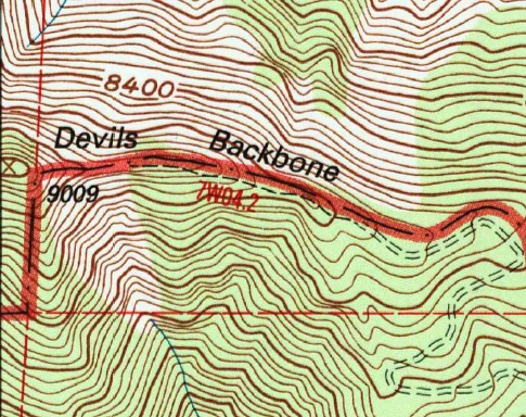
7W05.01 stops on top of subpeak 9009.
7W04.02 is from approx elevation 8700 to Baldy Notch.
The 1955 topo shows the exact same thing.

The use-trail in question has little to do with 9009, instead it starts its contour to avoid it.
Image
User avatar
Edward
Posts: 42
Joined: Sat Oct 11, 2014 11:02 am

Post by Edward »

The beginning of the Backbone trail just past the top of the ski run had cables similar to the cables on Mt. Whitney's 97 switchbacks. The remnants of the iron posts are still visible in a few spots. I read that they were installed long ago in response to some winter fatalities. I don't know why they are gone. Maybe they rusted out and there was no money to replace them.
Interesting. Also interesting the 1953 article that AW cites. I hiked the Devil's Backbone for the first time in 1969. I don't recall seeing the cables. The trail above, where it narrows while traversing the steep slope on the south side, had a few steps which were considerably spookier then than they are now.

I would not mind cables if they made safe a few yards on an otherwise safe route. But with snow on the route, they would only be encouraging people to continue on a route that can be hazardous in a number of places. So it looks like I am in agreement with AW there.

As usual, HJ has to throw water on the fire with his damn well-researched facts! Or is it gasoline? I saw AW's comment, but is it a true gap between two trails? Maybe. I have wondered why the trail does not continue straight up the ridge, where it looks like there is some rock to provide footing.

I'm learning some things here, nice discussion.
User avatar
Huff and Puff
Posts: 35
Joined: Sun Feb 07, 2016 1:33 pm

Post by Huff and Puff »

AW wrote:
Sean wrote: Trail designations appear on the USGS Topo maps.
Im aware of that, but neither trail deals with the backbone exposed section.
7W05.01 stops on top of subpeak 9009.
7W04.02 is from approx elevation 8700 to Baldy Notch.
The 1955 topo shows the exact same thing.

The use-trail in question has little to do with 9009, instead it starts its contour to avoid it.
Image
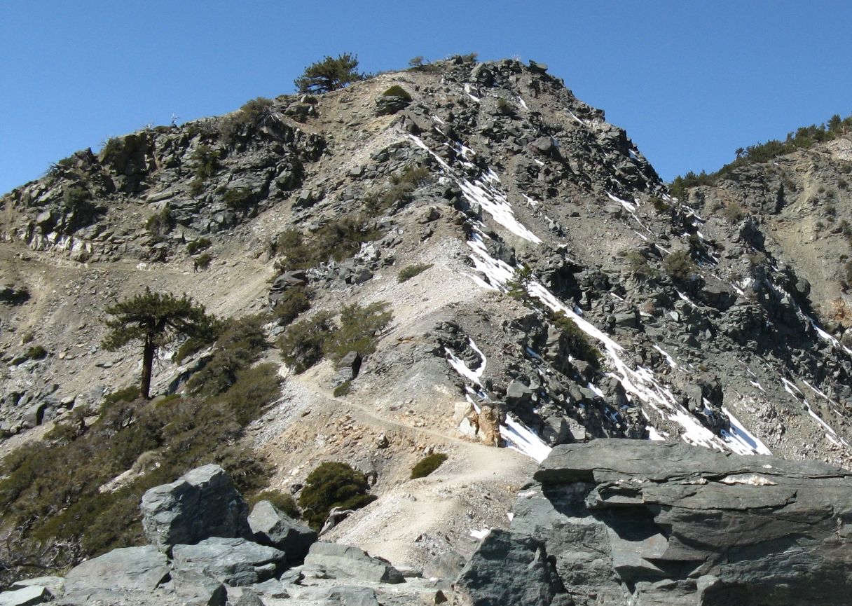
Is this the use trail that contours peak 9009?

Image
User avatar
Sean
Cucamonga
Posts: 3782
Joined: Wed Jul 27, 2011 12:32 pm

Post by Sean »

AW wrote: Im aware of that, but neither trail deals with the backbone exposed section.
7W05.01 stops on top of subpeak 9009.
7W04.02 is from approx elevation 8700 to Baldy Notch.
The 1955 topo shows the exact same thing.

The use-trail in question has little to do with 9009, instead it starts its contour to avoid it.
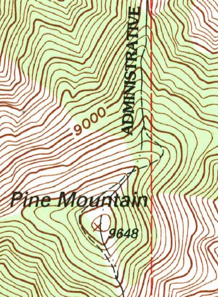
7W04.2 goes up to Pt. 9009' (The NF boundary), exactly like Jim said. Except that he misassociated the designations. 7W04.2 is actually in the ANF, and 7W05 is in the SBNF.

It is important to understand how the mapmakers dealt with boundary-trail overlap. Normally, the boundary is symbolized with a long line, one or two dots, and then another long line. But when it overlaps a trail, the symbols are integrated, thus the boundary-trail is represented with a long line, a dash, and another long line.

As for the "use trail" deviation from the line on the map, let's keep some context here. Trails are rerouted all the time, by the FS or by volunteers. This does not mean that the FS disowns the trail, simply because it's been reconfigured since the 1995 topo.

Also, CalTopo should not be used for such research as this. They sometimes omit things when stitching two USGS quads together. For example, you can see that CalTopo missed the trail designation east of 9009.

Image

And here is a clear example of what I was talking about regarding boundary-trail overlap.

Image
User avatar
Hikin_Jim
Posts: 4686
Joined: Thu Sep 27, 2007 9:04 pm

Post by Hikin_Jim »

Sean wrote: 7W04.2 goes up to Pt. 9009' (The NF boundary), exactly like Jim said. Except that he misassociated the designations. 7W04.2 is actually in the ANF, and 7W05 is in the SBNF.
Sean is correct. I reversed the two.

I can give you my lat lon down to 2 decimal positions. You'd think I'd know which frickin' forest I'm in. :lol:

HJ
User avatar
Edward
Posts: 42
Joined: Sat Oct 11, 2014 11:02 am

Post by Edward »

I've always taken the view that I am not concerned with fine details on maps, partly because I don't trust them, and partly because if they become important, I am in deep trouble already. But it is fascinating following discussions by people who are into them.
User avatar
Sean
Cucamonga
Posts: 3782
Joined: Wed Jul 27, 2011 12:32 pm

Post by Sean »

Ed wrote: I've always taken the view that I am not concerned with fine details on maps, partly because I don't trust them, and partly because if they become important, I am in deep trouble already. But it is fascinating following discussions by people who are into them.
Some amount of rational skepticism is healthy. But the USGS topo maps were created with a fine attention to detail and professionalism. I've discovered that the error rate is extremely low, hardly worth mentioning. However, they have not been updated in twenty years. So that's a problem sometimes. Overall, I trust these maps until I prove an error by personal observation.
User avatar
Edward
Posts: 42
Joined: Sat Oct 11, 2014 11:02 am

Post by Edward »

I forget to mention the visual problem. I was never eagle-eyed, and am much worse now. I need reading glasses to follow a trail on an original 7.5' map on the kitchen table. In the field, it's hopeless. Of course, you can trace over it with a pen. But I suspect my bold red trace is less than a perfect match to the original trail. If it is covered by Tom Harrison, that is what I use.
User avatar
RichardK
Posts: 727
Joined: Sun Sep 30, 2007 12:33 pm

Post by RichardK »

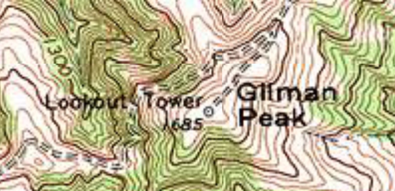
I believe that the USGS 7.5' maps are highly accurate when it comes to terrain. Man made structures are less accurate because these things can and do change. I was very disappointed on my first hike to Gilman Peak in Chino Hills SP to find that the fire lookout tower was gone.

Image
User avatar
AW~
Posts: 2040
Joined: Mon Oct 01, 2007 12:00 pm

Post by AW~ »

Huff and Puff wrote: Is this the use trail that contours peak 9009?
Looks good to me...I lose interest in this pretty fast because I get the same answer in the end. Its the road to mighty. 'If I want to mess this land up, I can mess this land up, because its my land, its my birthright'

"Our folks are spending every day, from the time their boots hit the ground in the morning to the time they collapse into their beds at night, finding what we call, simply, more. We define more as more people having more fun in more parks more often.That’s their sole goal in life, is to make sure that when the next generation of visitors comes to Utah, they are met with amazing family and friend activities that will cement those relationships for the eternities...."
User avatar
Sean
Cucamonga
Posts: 3782
Joined: Wed Jul 27, 2011 12:32 pm

Post by Sean »

AW wrote: Looks good to me...I lose interest in this pretty fast because I get the same answer in the end. Its the road to mighty.
The Road to Mighty

It's an ad campaign in Utah referring to that state's five national parks, which they call the Mighty Five. It promotes visiting the parks, not messing them up. I don't see how Utah's campaign relates to our discussion about the Devil's Backbone and map reading.
User avatar
AW~
Posts: 2040
Joined: Mon Oct 01, 2007 12:00 pm

Post by AW~ »

Sean wrote: It's an ad campaign in Utah referring to that state's five national parks, which they call the Mighty Five. It promotes visiting the parks, not messing them up. I don't see how Utah's campaign relates to our discussion about the Devil's Backbone and map reading.
It about monetizing their version of the parks. The Devil's Backbone is "devilishly exciting". And the rest of it is going to be their road to mighty, since they know better than anyone and have the political power.
You really think those signs have some adaptive purpose lol? That defies the open borders. They are tourism signs. Nothing to do with the environment, nothing to do with safety, nothing to do with forest design. They are a big yawn....wheres the admission fee? Wheres the taxes? Wheres the hardball? http://www.outsideonline.com/2103006/mr ... washington
Post Reply