Cabin Hunting in Dark Canyon

TRs for the San Gabriel Mountains.
Post Reply
User avatar
Sean
Cucamonga
Posts: 3787
Joined: Wed Jul 27, 2011 12:32 pm

Post by Sean »

Yesterday Dima, Henry, and I joined forces on a cabin hunting mission in Dark Canyon. These cabins occupied the banks of the streambed until the great flood of 1938, which permanently shut down the area to motor traffic. The Brown Mountain debris dam was constructed in '42 for flood control, and the cabins in Dark Canyon were demolished or abandoned when the Forest Service assumed management of the watershed.

We started our hike at 8am heading down the CCC Ridge and connecting with the old road into Dark Canyon.

Image

The initial descent to the stream proved relatively easy. Most of the roadbed still exists, and a good use path can be followed. Only a couple washouts and landslide sections required extra care in passing.

Image

The real fun began once we reached the main branch of Dark Canyon. Nearly eighty years of neglect has rendered the lower road sections practically nonexistent, especially where it crosses the stream.

Image

At times the canyon scramble offers heavy brush and log crossings. Other times there is a recognizable use path.

I had printed out copies of the 1939 topo map, and we used it to locate some cabin sites and ruins.

Image
(Sitting on steps at the first cabin site)

Image
(Henry between cabin walls)

Image
(Steps leading from a cabin site down to the stream)

Image
(The only remaining pillar structure we found, perhaps used to support an arch or porch.

The most intact cabin had been surprisingly renovated by someone not present during our visit, but who shall be referred to as Darkman.

Image

Image
(Henry and Dima at the entrance to Darkman's Cabin)

Image
(Inside Darkman's Cabin)

Around 11:30am we reached the Oakwilde site at the mouth of Dark Canyon, where it empties into the Arroyo Seco. A fairly thorough search of the area revealed only a few items of historical interest, including a retaining wall.

Image

If you follow the flagged trail you'll also come across some circular slabs and a small stone pillar.

After grabbing a bite to eat, we continued up the Arroyo Seco, following the recently worked Gabrieleno Trail.

Image

A few downed trees remained to be cleared.

Image

Otherwise it was an easy and scenic trip along the Gabrieleno, and we had fun collecting other people's trash and balloons.

Image

The trail left the Arroyo Seco and climbed around an active waterfall into Long Canyon.

Image
(On the trail above the Long Canyon Falls)

The trail stayed above the Long Canyon stream, on the south side. After approximately a mile into the Canyon, we decided to leave the trail and continue cross-country up the Canyon going north, where the trail sharply turns to the south.

Image
(Dima climbing the dry falls at the start of our cross-country section in Long Canyon)

Image
(Henry getting up the waterfall)

After working a bit to climb the falls, we had a decent stretch of light bushwhacking while following the water course upward.

Image

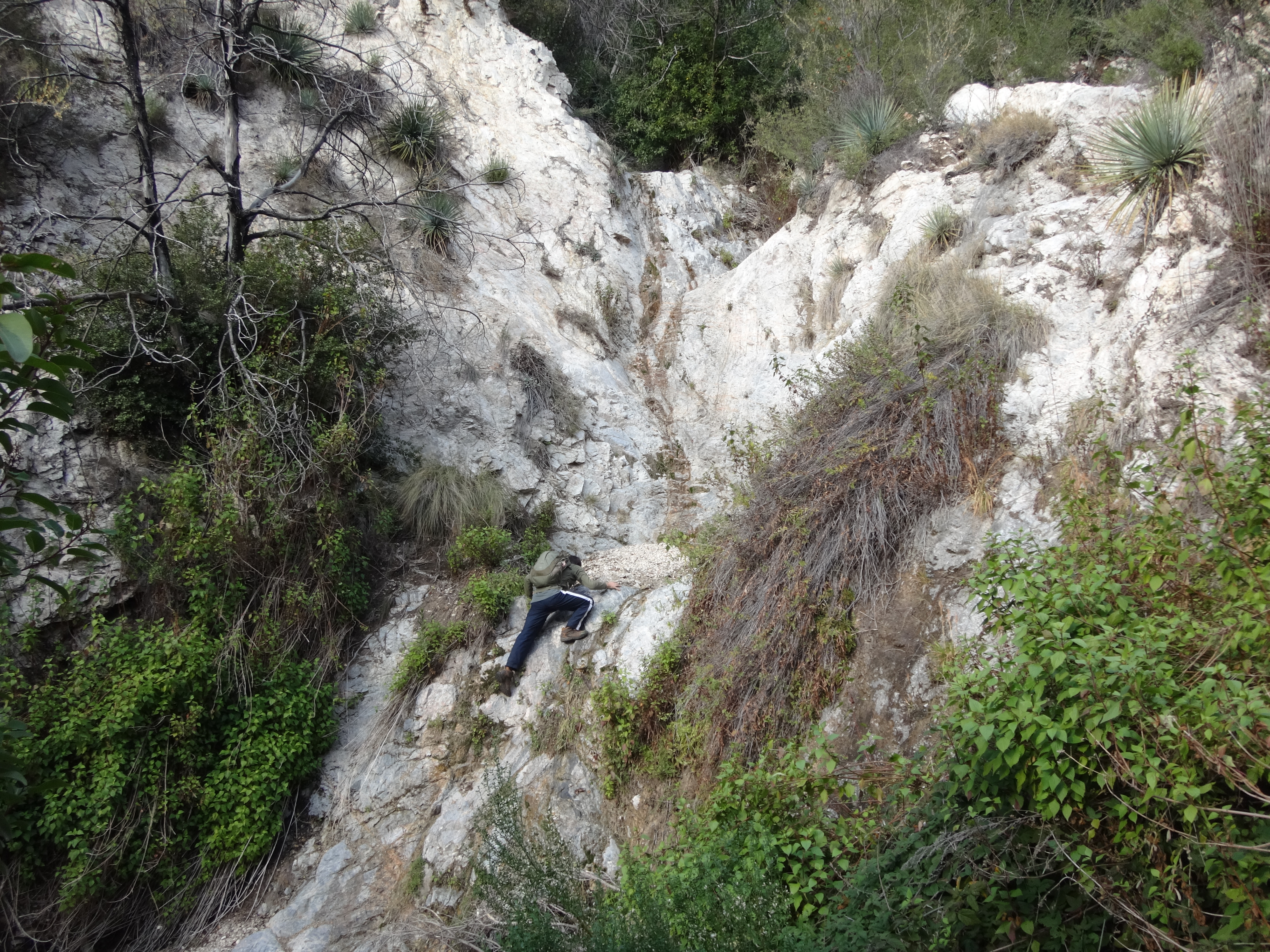
Then we encountered a bigger and badder dryfall.

Image

This one had to be bypassed along the left side. Using all fours, and grabbing branches for leverage, we made it up the very steep and loose slope to the ridge.

Image

By now the predicted storm clouds were rolling in, and we decided to stick to the ridge for a quicker exit to the highway, which was now in view directly north of us, a rough half-mile or so away. This area has some neat rock features.

Image

Image

Dima pushed ahead, locating an obscure animal trail which contoured around the final bump and saved us some difficult scrambling.

Image
(Dima contouring around the final bump, with the highway in sight.)

We then dropped down a little ridge and crossed the gully below the road, before finding a way out on the other side.
User avatar
dima
Posts: 1354
Joined: Wed Feb 12, 2014 1:35 am

Post by dima »

The only thing I have to add are these bicycle remains found maybe half a mile above Oakwilde:

Image

This is not an easy place to get to on a bike. This person probably rode in from JPL, cycled around the dam, pushed through the soft, sandy bottom of the arroyo until the point in the photo. Then they gave up, dropped the bicycle into the river, removed the wheels, tires, chain and seat, and kept walking upstream, carrying with them one tire, one tube, the chain and the seat for protection. Then they were probably eaten by a bear.
User avatar
tekewin
Posts: 1195
Joined: Thu Apr 11, 2013 5:07 pm

Post by tekewin »

Looks like a fun canyon adventure!

Now, who is the mysterious Darkman and when will he return?
User avatar
Uncle Rico
Posts: 1402
Joined: Thu Mar 20, 2008 7:48 pm

Post by Uncle Rico »

The only thing I have to add are these bicycle remains found maybe half a mile above Oakwilde
WTH? That's so random. Lol. :?
User avatar
walker
Posts: 248
Joined: Mon Apr 08, 2013 11:14 pm

Post by walker »

Nice one, guys! An impressive piece of work.

I remember hearing about several bicycle misadventures/rescues where at least two or three parties since the station fire have tried to ride down the unmaintained Gabrieleno trail from Switzer's or thereabouts. It seems they would ride for a while, then bushwack a while and end up stuck at the top of Brown Mt Dam, unable to find the high trail around the dam. I can only imagine they read descriptions of the ride from before the fire not realizing how far it really is and how impassable it has been since the fire.

Perhaps those bikes were left by these fellows:

http://www.amrt.org/blog/entry/amrt-res ... er-29-2014
User avatar
Sean
Cucamonga
Posts: 3787
Joined: Wed Jul 27, 2011 12:32 pm

Post by Sean »

That sounds like the ones, which means there might be a second abandoned bike. Anyone want to help me pack them out?
User avatar
AW~
Posts: 2043
Joined: Mon Oct 01, 2007 12:00 pm

Post by AW~ »

Cool...some canyoneers have been looking at a tributary to Long canyon. Too late I say LOL....just after the Station Fire was the time to do it.

There is another picture after that with those rock formations...are they worth hiking to and is there anything to do after that or?
User avatar
Sean
Cucamonga
Posts: 3787
Joined: Wed Jul 27, 2011 12:32 pm

Post by Sean »

AW wrote: There is another picture after that with those rock formations...are they worth hiking to and is there anything to do after that or?
We went up the east fork of Long Canyon, north from the Gabrieleno Trail. In about a half-mile stretch, there are at least two big falls, one medium one, and several small ones. At the head of the canyon is a huge climbing rock. People have placed an anchor on top. There are also some cliffs across from the rock.
User avatar
dima
Posts: 1354
Joined: Wed Feb 12, 2014 1:35 am

Post by dima »

I had a few free hours today, so I fished out the bicycle. If anybody needs a lightly-used child's (or other small human's) hardtail, holler.
User avatar
Sean
Cucamonga
Posts: 3787
Joined: Wed Jul 27, 2011 12:32 pm

Post by Sean »

Did you see any evidence of a second bike?
User avatar
dima
Posts: 1354
Joined: Wed Feb 12, 2014 1:35 am

Post by dima »

Sean wrote: Did you see any evidence of a second bike?
No second bike. I'm skeptical the S&R report from above is related here since this was a child's bike, and there wasn't enough rust to make me think it's been there for a year. And there's the whole question about why it was dismantled...
User avatar
dima
Posts: 1354
Joined: Wed Feb 12, 2014 1:35 am

Post by dima »

Bumping thread since I just stumbled on a new piece of info. So apparently cougarmagic found this very bike in Dec 2014:

viewtopic.php?p=50577#p50577

This was 9 days before the rescue in walker's link, so isn't from that incident. It really didn't look that bad for lying in the Arroyo for years.
Post Reply