
http://www.everytrail.com/view_trip.php?trip_id=845551
Driving portion
http://www.everytrail.com/view_trip.php?trip_id=848007
Cucamonga Peak is on the south facing ridge on the east end of the San Gabriel Mountains. The is one of the more obscure routes. Even more so since the 2003 Grand Prix Fire.
Since that time San Sevaine & Big Tree roads have not regularly been open. Apprently they are open for hunting season after Labor Day, but what the schedule is ???
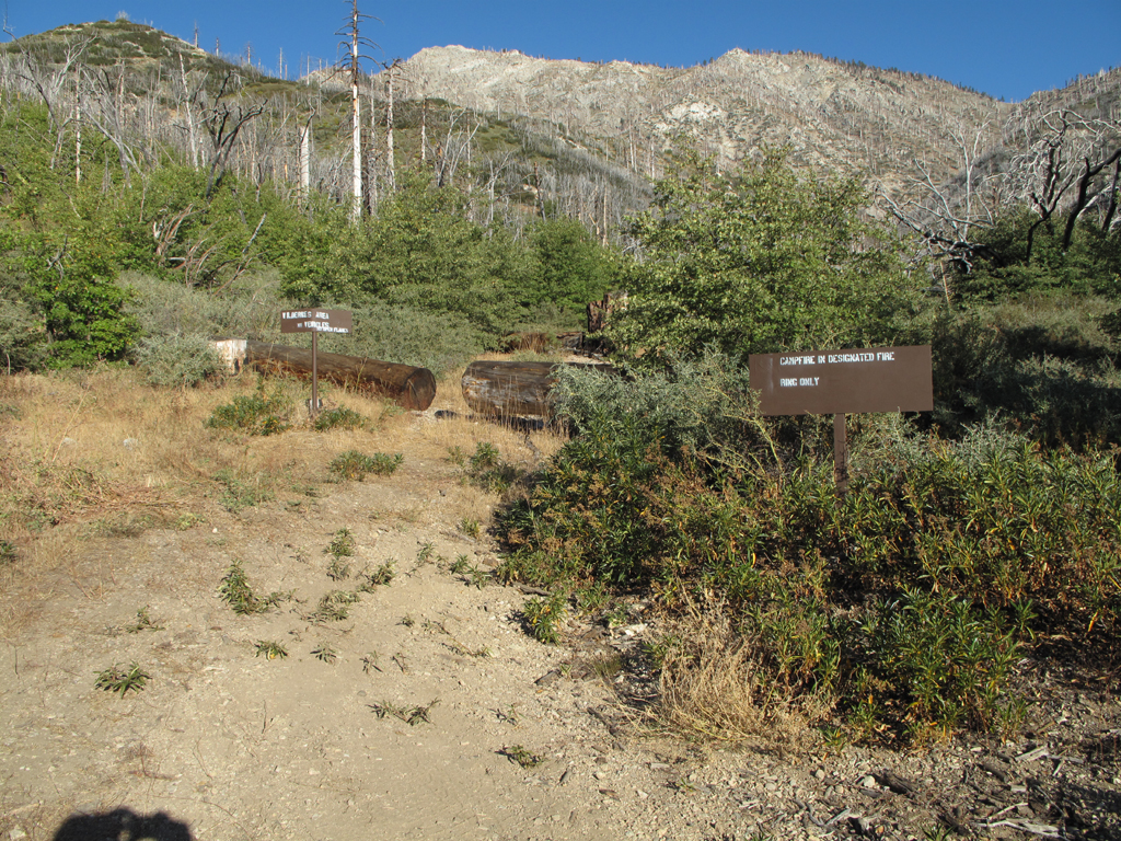
The trailhead is not obvious nor is the trail but it is there! There are two old signs something about "wilderness area" and a large 4' log with a pass through.
The Oaks seem to be recovering but the Pines do not. My cogent analysis is the fire burned hot sterilizing the soil. The pine nuts where burned. Now the Scrub Oak and the hated Buckthorn are taking over. Maybe sometime in 200 years from now it may recover somewhat but certainly not in any human scale time.
After leaving the wash you climb up on a ridge and back to the wash. There are some interesting cliffs on the south side of Etiwanda Peak (HPS name), further on you cross another wash with a saddle above. (possible XC "shortcut")
From there you switchback on a well built trail but now unmaintained detouring around down trees to another ridge... More down trees, toward a prominent saddle. Here we stayed on the trail but I'd recommend you go XC up the ridge to rejoin the trail as there are 8-10 down trees on the next trail segment.
The fire didn't make it onto the north facing side and is welcome relief to the fire scarred south. BTW higher up there are some pine tree seedlings! WAHOO WAHOO!
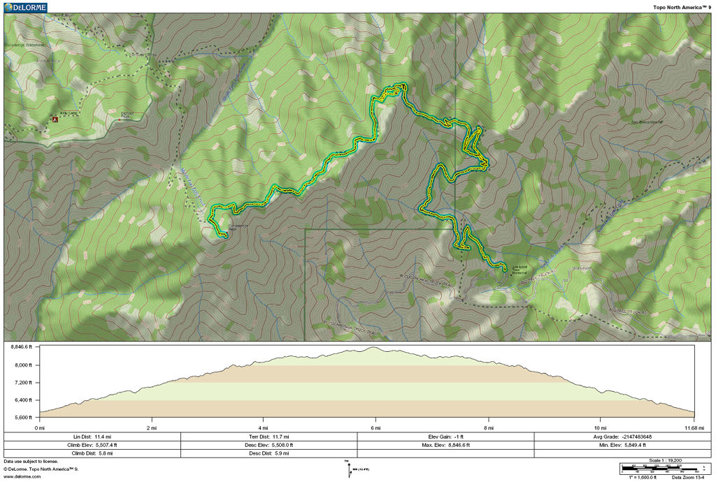
At 3 miles 7740ft you cross the saddle you saw from the 2nd wash crossing. Past here the trail switchbacks through lush pine forest. You cross another saddle at 3.87 miles 8294ft. The trail narrows and cross a few vertigo inducing slide areas.
8475 ft there is a use trail to the Etiwanda Peak (7.00)
4.62 miles 8354ft is the final ridge top saddle. Shortly after here you reach a small bowl like area. The trail is difficult to follow here. But continue straight to an old sign and you'll see the trail on the right.
The trail goes around the north side of Cucamonga Peak and meets the trail up from Ice House Cyn Saddle @ 5.5 miles 8627ft. At this point I realized I no longer have my SPOT II clipped on my pack.
It was very windy on this day and gusts on the summit where probably 40 MPH. Had a bit of lunch and started down, I stopped when I got a good cell phone signal and called my son Ian who relayed the SPOT's Lat/Long while Bernd went ahead to look for the unit.
The coordinates where dead on but it was right on the trail...Couldn't miss it(?)
On the way down we collected trash left by some hunter and pick up some Mylar balloons along the way.
My GPS indicated 11.36 miles when we arrived there at 2:30pm. Roughly 6½ hours.
Cucamonga Peak from San Sevaine Rd 101010
-
Hikin_Jim

- Posts: 4688
- Joined: Thu Sep 27, 2007 9:04 pm
Hi, Matt,
I've never done Cucamonga from the east. Sounds interesting despite the abandoned trail and the Grand Prix fire.
So, you did find your spot? Guess that tracking feature is worth the 50 bucks.
HJ
I've never done Cucamonga from the east. Sounds interesting despite the abandoned trail and the Grand Prix fire.
So, you did find your spot? Guess that tracking feature is worth the 50 bucks.
HJ
-
HikeUp

- Posts: 4025
- Joined: Thu Sep 27, 2007 9:21 pm
Dang I'm jealous Matt! Nice TR.
What kind of vehicle would you recommend for that road - 4wd? high clearance? standard car ok?
What kind of vehicle would you recommend for that road - 4wd? high clearance? standard car ok?
-
lilbitmo

- Posts: 1092
- Joined: Tue Mar 04, 2008 9:44 pm
Nice Report Matt, sounds like it's worth the effort, glad you were able to find the Spot 
-
mattmaxon

- Posts: 1137
- Joined: Mon Mar 24, 2008 12:48 pm
Yeah the SPOT was right spot on  My son said it hadn't moved since 10:30am
My truck is a 1995 Toyota Tacoma extra cab 2WD, 2.4L 2RZFE engine
It has more ground clearance than the average passenger car but not much.
I've taken it in many places people with 4WD wouldn't go.
There is one very steep segment a short way past San Sevaine Flat that seems like it's 20-30% grade. Real keaster puckering experience.
Once you start up there is no place to turn around, you could only back down, which would be F@#*ING scary IMO, IE do not go over the edge, it is a long way down.
But if you're asking me, if you have access to 4WD use it, the more the ground clearance you can have the better
I do not think a standard passenger car could make it, at least not your own car... A rental could make it, you'd be in the clear so long as they didn't look at the bottom of the car
Watch out for numb skulls driving way too fast for single lane dirt roads
Cheers
Matt
-
Taco

- Snownado survivor
- Posts: 6124
- Joined: Thu Sep 27, 2007 4:35 pm
Good access to the south face of Etiwanda. Take any cool pics of the cliffs there or anything absurdly steep and preferably "impossible"? 8)
-
mattmaxon
- Posts: 1137
- Joined: Mon Mar 24, 2008 12:48 pm
Didn't take many photosTacoDelRio wrote:Good access to the south face of Etiwanda. Take any cool pics of the cliffs there or anything absurdly steep and preferably "impossible"? 8)
-
Taco
- Snownado survivor
- Posts: 6124
- Joined: Thu Sep 27, 2007 4:35 pm
Thanks Matt!
Figure there's a shortcut to get to Etiwanda from MFLC...
Figure there's a shortcut to get to Etiwanda from MFLC...
-
HikeUp
- Posts: 4025
- Joined: Thu Sep 27, 2007 9:21 pm
-
EManBevHills

- Posts: 387
- Joined: Fri Sep 28, 2007 12:40 am
Always wanted to do this route. Thanks, Matt, for the beta!
-
RichardK

- Posts: 727
- Joined: Sun Sep 30, 2007 12:33 pm
I have wondered about this route to Cucamonga. Thanks for posting the report. Unfortunately, I don't have a suitable vehicle for the road.
-
Sean

- Cucamonga
- Posts: 4227
- Joined: Wed Jul 27, 2011 12:32 pm
I dug this thread up because I'm interested in any current information on the Cucamonga Peak Trail segment between Joe Elliot CG and Etiwanda Peak. I've never done this portion myself, but I'm planning to do it sometime this spring as part of a larger fastpacking adventure.
Specifically:
1. What percentage of the trail segment is difficult to follow? Did you ever lose the trail? If so, where did you lose it?
2. What percentage of the trail segment is bushwhacking? What sort of bushwhacking (typically light, heavy, and/or thorny brush, generally up to knees, waist, or head)? Are there still downed trees across the trail? If so, about how many?
3. What percentage of the trail is covered in rocks? Generally what size are the rocks?
4. Are there any reliable water sources on or very near the trail during May or June? Is there water at Joe Elliot?
5. I estimate the distance between Joe Elliot and the Etiwanda turnoff to be 3.6 miles. What do you think? (A GPX file would be much appreciated.) I'm unsure whether the Cucamonga Peak Trail begins at Joe Elliot or slightly beyond it. If beyond, what is the distance to the TH from Joe Elliot?
6. Lastly, does anyone have images of the trail itself, including the trailhead at/near Joe Elliot?
Thanks in advance for any replies.
-
jfr
- Posts: 154
- Joined: Sat Dec 12, 2009 3:01 pm
I've never been on this trail (or the road) but I can help with the gpx file, as the Cucamonga Wilderness is actually part of the San Bernardino National Forest and not the Angeles NF. There is an excellent Google Earth kmz file of every dirt road and trail (and more!) in the SBNF:Sean wrote: 5. I estimate the distance between Joe Elliot and the Etiwanda turnoff to be 3.6 miles. What do you think? (A GPX file would be much appreciated.) I'm unsure whether the Cucamonga Peak Trail begins at Joe Elliot or slightly beyond it. If beyond, what is the distance to the TH from Joe Elliot?
Thanks in advance for any replies.
http://www.fs.usda.gov/Internet/FSE_DOC ... 213004.kmz
Save that file and load it into Google Earth. Zoom in to your zone (Big Tree Cucamonga Road and the Cucamonga Peak-Icehouse Saddle Trail). Right-Click either one and select "Show Elevation Profile." That'll give you some mileage and elevation data.
If you want a gpx file to load into your gps, you can export from GE the road and trail into individual .kml files. To do this, right-click the trail or road, select "Properties." The individual trail should then be showing/highlighted in the Sidebar on the left. Right-click the trail in the sidebar and select "Save Place As" then use the pull-down to save it as a .kml file rather than a .kmz file. You can convert a .kml file into a .gpx file using the freeware gpsbabel program (I'll let you have fun learning to use gpsbabel on your own).
Have a great hike, and be sure to post pics not only of the trail but also of the dirt road!
P.S. Now how do we get the Angeles National Forest to produce a kmz file of all of their trails and dirt roads???
My hiking trip reports: https://hikingtales.com/
-
Elwood

- Posts: 620
- Joined: Fri Aug 15, 2008 5:23 pm
I hiked this trail three weeks ago, and several time in the past few years. I have plenty of pictures that I'll post, but not today. A few sections of this trail are quite dangerous; high traverses on steep scree, where the trail has slid out. Bonus: I've seldom failed to see Ovis canadensis nelsoni when hiking this area.
1) Save for one spot where the trail turns around the bump at 8368' it's very easy to follow.
2) Little or no bushwacking per se. Though the trail is unmaintained, folks including myself periodically trim back ceanothus, yucca, etc. that have overgrown the bed. There are an increasing number of deadfalls to climb over or navigate around. I would estimate around a dozen of these. Much of the forest is dead here following fires; each winter seems to drop a trunk or two.
3) Terrain varies as does most in the Gabriels'. Some dirt, some scree, some talus, and everything in between.
4) There is a drainage in Elliot that may still be running in May/June depending upon remaining snow and precipitation this winter. Same for the main drainage dropping due east from Etiwanda. I've never felt it prudent to rely on these.
5) http://www.electricskates.com/Pix/Other22/Current.gpx
Trailhead is at the northwest corner of Joe Elliot at the marked Cucamonga Wilderness boundary.
6)
-
Sean
- Cucamonga
- Posts: 4227
- Joined: Wed Jul 27, 2011 12:32 pm
Thanks, JFR. According to the KMZ file, the segment is about 3.7 miles, and the trail starts at the CG.
-
Sean
- Cucamonga
- Posts: 4227
- Joined: Wed Jul 27, 2011 12:32 pm
Thanks, Elwood. That information is tremendously helpful. I'm planning to do my first 50-mile fastpack covering every official trail in the Cucamonga Wilderness. I'd like to be able to jog at least half of the descent to Joe Elliot from Etiwanda, and then power walk back up with a 2 or 3 mph pace.
-
wiggingout
- Posts: 10
- Joined: Thu Jan 10, 2013 9:45 am
I love MFLC>Etiwanda! I did this back in October, or late September awesome hike!
-
cahikr
- Posts: 15
- Joined: Fri Oct 17, 2014 3:16 pm
Saw the road open last weekend and have always wondered about this trail.
I and going to try to get this one in next Saturday the 8th of Nov. if anyone is interested in joining. I have a very capable 4x4.
I and going to try to get this one in next Saturday the 8th of Nov. if anyone is interested in joining. I have a very capable 4x4.
-
Chicken Legs
- Posts: 33
- Joined: Fri Oct 19, 2007 12:04 am
Did you end up making the hike on Nov 8th?
Last season, a buddy and I made it to the trail head on an recon trip on our motorcycles to see what shape the road was in. But haven't made it back up there to do the hike.
Curious on current conditions...any update would be helpful.
Thanks
Last season, a buddy and I made it to the trail head on an recon trip on our motorcycles to see what shape the road was in. But haven't made it back up there to do the hike.
Curious on current conditions...any update would be helpful.
Thanks
-
cahikr
- Posts: 15
- Joined: Fri Oct 17, 2014 3:16 pm
Yes I did this hike on November 8th.
The road to the trail head took approx. 1hr. 10 min and was in very good condition, easily made by any 2 wheel drive vehicle with decent clearance.
Started the hike around 6:30 am and was quite surprised at what great condition this trail was in for the exception of about a dozen or so fallen trees that crossed the path. I traveled as far as Cucamonga peak arriving around 9:15 and after a 30 minuet break started back down the trail traversing the ridge line most of the way to Etiwanda. Finished the hike around 1:00 pm. Other than the long drive to the trail head this was a very enjoyable hike with only two other hikers passed along the way.
-
Chicken Legs
- Posts: 33
- Joined: Fri Oct 19, 2007 12:04 am
Thanks for the info. I need to get this hike done in the near future.
-
Sewellymon
- Posts: 109
- Joined: Tue Feb 12, 2008 8:55 pm
I've got a Toyota FJ Team Edition. It'd cruise the road without issue.
I could be talked into this hike. Been eyeballing it on the map for 40 years.
I could be talked into this hike. Been eyeballing it on the map for 40 years.
-
cahikr
- Posts: 15
- Joined: Fri Oct 17, 2014 3:16 pm
My FJ made it in 2 wheel drive with no problem.Sewellymon wrote: I've got a Toyota FJ Team Edition. It'd cruise the road without issue.
I could be talked into this hike. Been eyeballing it on the map for 40 years.
It's not that the road is difficult it's just a long way to the trailhead approx. 1 hr. 15 min.
Might need to wait until next year to do it though as they close the road for the season at the first heavy snow fall, and it's raining hard out right now.
-
Chicken Legs
- Posts: 33
- Joined: Fri Oct 19, 2007 12:04 am
When the gate opens back up, lets take a run at it...
-
Mike P

- Posts: 1005
- Joined: Tue Oct 02, 2007 10:48 pm