
This is the other side of the coin to walker's TR of his ascent to Point 4441 yesterday afternoon. While walker was making his way up to Gold Creek Saddle from Little T, I was coming up the other side from Trail Canyon in Big T. My objective was Mt. McKinley, but I got such a later start that I had to turn around about 30 minutes before the summit to avoid getting down in the dark.
As you know, the route to Gold Creek Saddle from Trail Canyon is by way of a meandering fire road that takes it's own sweet time ascending to the saddle. The gradual ascent, and the way the fire road winds in and around every conceivable drainage and prominence reminds me a lot of the route to Fox Peak. As walker mentioned, from Gold Creek Saddle to the saddle between Point 4441 and McKinley the path is somewhat overgrown but easily passable. Beyond the saddle between Point 4441 and McKinley, the path is very overgrown and quite brushy in places. Doesn't look like it's had any maintenance in a long time.
After I met walker at the saddle, I ran into 3 guys on motorcycles. Those were the only folks I saw all day. On the way down, the clouds moved and created some interesting lighting. The sunset as I neared the trailhead was amazing.
The only bummer of the whole day was when I got back to my car. Some thugs had broken my passenger side rear window and rummaged through my car looking for valuable. They got none but I'm still stuck replacing the window. When I parked at the trailhead there were several other cars there with Adventures Passes hanging from their mirrors so figured there'd be safety in numbers. I was wrong, maybe because my car was the only one at the trailhead by the time I got down.
Oh well, what are you gonna do? Another spectacular day to be out.
Ascending Gold Creek Road
Lukens and Friends
View Down Big T Canyon
Trail Canyon
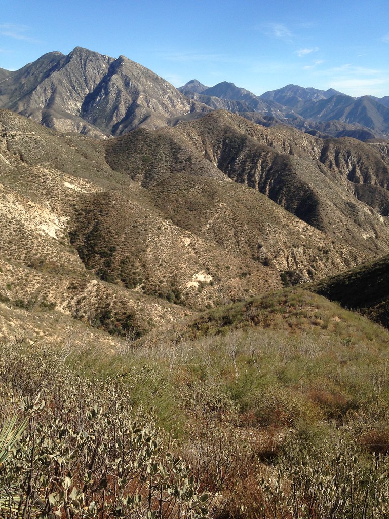
Point 4441 and McKinley. You can see the path cutting across the face of Point 4441.
Leftovers
Looking back at Lukens as you near Gold Creek Saddle
Typical trail conditions between Gold Creek Saddle and the saddle between Point 4441 and McKinley. The trail worsens considerably beyond that saddle.
Pano at saddle between Point 4441 and McKinley
View down Gold Creek drainage from my turn-around point
View of Point 4441 on my return trip
329 Days of Sun at Yerba Buena Water Tank
Clouds moving in over the ridge on my descent
Condor in the last light
Ojai is not the only place with pink moments
Sunset over Big Tujunga Canyon
Blow out window
Remnants of Big T Thugery
Finis
Smashed Windows and McKinley Fail: A Great Day
-
RichardK

- Posts: 727
- Joined: Sun Sep 30, 2007 12:33 pm
Sorry to hear about your car. We got "car clouted" once in Death Valley while hiking Corkscrew Peak. Luckily, the Safelite in Vegas had the glass in stock though we lost a hiking day dealing with it. Great report and pictures!
-
Hikin_Jim

- Posts: 4688
- Joined: Thu Sep 27, 2007 9:04 pm
Bummer about the car windows. Nice TR. I'm digging on the alpenglow pics.
HJ
HJ
-
AW~

- Posts: 2090
- Joined: Mon Oct 01, 2007 12:00 pm
Some vandals also got the baseball field before the forest as well...
http://www.prweb.com/releases/2014/11/prweb12334050.htm
"The artificial turf field on Big Tujunga Canyon Road, was stolen overnight on Saturday November 8. Sunday morning as parents and their young ball players went to the field to start practicing, they were greeted with nothing but gravel, dirt and what was left of the turf’s infill. Thieves had torn up and removed the field within hours"
Great pictures of Condor Jr though.....I want to hike that peak(would be attempt #2)...maybe on a weekday?
-
walker

- Posts: 248
- Joined: Mon Apr 08, 2013 11:14 pm
Hey, Rico, great to see you up in the hills again. Sorry about the window. I guess every day in the Big-T is like Mardi Gras. I've never seen so much broken glass in my life as the last time I was poking around monkey canyon below the guaging station about 10 years ago. It still like that?
Those sunset shots are amazing, hopefully those moments helped balance it out a little.
Do you think the frustratingly long, meandering road is a moderate enough grade to get up on a bicycle?
Those sunset shots are amazing, hopefully those moments helped balance it out a little.
Do you think the frustratingly long, meandering road is a moderate enough grade to get up on a bicycle?
Is Condor Jr the pointy one that's looming over Trail Canyon? Looking up at that thing has always been one of the highlights of a hike up in the area. Would you take a direct route up from around Tom Lucas or somewhere? Here's a photo of it from Gold Creek Road:Great pictures of Condor Jr though.....I want to hike that peak(would be attempt #2)...maybe on a weekday?
-
Uncle Rico

- Posts: 1481
- Joined: Thu Mar 20, 2008 7:48 pm
Oh yeah, definitely. There was a couple of loose spots and a wash-out or 2 but nothing major. No real steep sections either. Riding is probably the better option if truth be told.Do you think the frustratingly long, meandering road is a moderate enough grade to get up on a bicycle?
I'll defer to Canyon Man on the Condor Jr. options. Coming at it directly out of Trail Canyon looks pretty darn imposing to this old man.
-
tekewin

- Posts: 1374
- Joined: Thu Apr 11, 2013 5:07 pm
That stinks about the car, Rico. I am getting concerned about parking anywhere in the front range where thugs can easily cruise by.
Photos are fantastic. I really like the whole big T area.
Photos are fantastic. I really like the whole big T area.
-
mattmaxon

- Posts: 1137
- Joined: Mon Mar 24, 2008 12:48 pm
walker wrote: Do you think the frustratingly long, meandering road is a moderate enough grade to get up on a bicycle?
I rode to Gold Creek Saddle 2/24/2014
http://connect.garmin.com/modern/activity/451737891
Plenty of sandy spots and rocks not something I am going to repeat anytime soon
-
AW~
- Posts: 2090
- Joined: Mon Oct 01, 2007 12:00 pm
Thats the one. I tried from just upstream of Trail Canyon Falls on a hot day and quit once the sun came out LOL. That is the way up though.walker wrote: Is Condor Jr the pointy one that's looming over Trail Canyon? Looking up at that thing has always been one of the highlights of a hike up in the area. Would you take a direct route up from around Tom Lucas or somewhere? Here's a photo of it from Gold Creek Road:
The way it has been done was by coming up Ybarra side and then down to Trail Canyon....thats documented on Google Earth, but it was when the area was closed from the Station Fire.
-
Taco

- Snownado survivor
- Posts: 6125
- Joined: Thu Sep 27, 2007 4:35 pm
Sucks about that incident. I like your choice of car, though. Real fun.
Cheers
Cheers