
My friend Tom and I, thinking we were bigger men than we apparently are, decided to have a go at the SW ridge of Iron Mountain via the Heaton Flats trail to Allison Mine on Sunday 3/30/14. I had planned to essentially follow this route.
The night before I load several waypoints from @Hikin_Jim into my GPS to help navigate to Allison mine and I am ready to go get it.
After Tom nearly gets a speeding ticket on the way in we meet at Heaton Flats around 7 am. He's very happy having only received a warning. Despite showers in Irwindale on the drive, the weather looks like it’s going to be perfect. A little warm up from the parking to Heaton Flats. Plenty of permit slips in the box, even a pencil. This is going great!
Starting strong we make Allison\Heaton Saddle in a little over 2 hrs. The split to Allison Trail isn't well marked but we know where to look and where it needs to go (see image of the route). We find it's a pretty obvious fork in the brush (really just take the first fork to the left you see as you’re crossing the saddle). The traverse was in ok shape. The trail is well established and apparent, though washed out in places and a little overgrown. Not the kind of trail where you make great time but that makes the adventure feel more authentic.
Shortly after the split @ Heaton Saddle
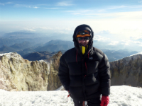
Tom checking out the view
One of the washed out sections
A lot of the Yucca is trimmed along the way but still very close on the trail
The nature of the trail adds a lot to the sense of adventure while still giving a clear path to follow. (In many places the slope and trail are falling away. It's easily passable but careful attention is required.) The downside to the traverse trail is ticks are ever present. Tom has to be very aware wearing short sleeves.
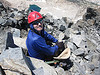
It takes nearly an hour and a half to reach Allison mine. Once we do reach the mine we take a few minutes to explore the obvious shafts. One is directly on the trail. We seem to have lost the trail at the first shaft so slide down a short step to find a second shaft just a little way toward the gorge. After only a minute or so at the second shaft, looking at the daunting ridge ahead of us, we decide to get going.
After a hop, skip, and a jump or two we are on the other side of the gorge and on the southern foot of the SW ridge. We follow a clear trail (this seemed to be the continuation of the traverse trail which led to Allison mine from the saddle and continued in much the same state) keeping an eye up slope for anything that could be a trail starting up to the ridge. After a short distance it’s clear we've either missed any trail to the ridge or it no longer exists, so we turn and go straight up hoping to pick our way through the brush up to the SW ridge. (According to SP we should have followed a talus chute, which seemed pretty unstable when we crossed it following the trail we were on. Tom says we should try it next time.)
Without a clear way through the brush and yucca, progress up the steep slope is slow and requires a lot of investigation to find a way through. After gaining only around 300 feet in nearly 30 minutes we run into a dense thicket of brush. (I'm not confident the talus chute recommended on SP would have bypassed this as we traversed a good way along the slope looking for a possible path through.) After pondering the 3500' remaining we decide it would be a mistake to try to force through the brush and that we should work our way back down to the trail. We turn and pick our way back down, surfing large rocks and scree as carefully as we can. We try to avoid, the yucca, sending a wave of rock down on anyone or thing below, or tumbling out of control down the steep slope ourselves. Once we get back down to the trail we quickly find a stable place which is wide and flat enough to sit on the trail, empty our shoes (not for the last time) and have a bit of lunch. Relieved that we made it through the toughest part we’re confident that we can just head back the way we've come or out through Allison gulch.
Based on reports and comments researched beforehand a trail should continue from Heaton Flats up Allison gorge and ultimately to Allison mine. It was even suggested that this approach is the faster means of reaching Allison mine. The trail is even marked on my US Topo! 2008, good to go! After a bite to eat, looking to avoid doubling back and possibly the ticks, we follow the trail paralleling Allison Gorge expecting it to be in at least as good shape as the traverse from the saddle.
After only a short distance we are surprised at how steep the trail has gotten, after only 1 or 2 "switchbacks" anything that resembles a consistent trail is gone. "That's OK I have the GPS with the trail marked" I think to myself. After more traversing to navigate brush, trying to keep some relation to the line shown on the screen, we arrive at a choice between continuing to attempt to traverse on loose, sandy dirt mixed with very broken rock on an increasingly steep slope or to just go for it and follow the indicated line straight down what appears to be a shallow shoot leading through brush only a foot or so off the ground.
Tom is the first to take the leap. I look over and sure enough there's Tom lying on his back in the dirt and rock waterpark style. He pushes off and goes sliding feet first straight down the shoot under and through the brush. I give up the traverse; make sure he has a good head start, then follow. Roughly 1000' later my a$$ hurts, but we are down in the creek bed. I swear that I left the seat of my pants somewhere on the slope but Tom assures me I remain decently covered so we empty our shoes for the second time and start winding our way down, linking broken remnants of a trail that has clearly ceased to exist years ago, mostly picking our way through various obstacles in the dry creek bed
About a mile later we emerge to the East Fork of SGR to empty our shoes for the final time before following the crowds returning from Bridge to Nowhere and elsewhere along the river. It’s the first time either Tom or I have walked this path. We are both amazed; at the number of people out enjoying the river, at yucca thriving among oaks right on the banks of the river, at the huge, impressive rock faces and cliffs towering over.
Elevation profile
Full track:
Mine and Gorge Descent Zoomed track:
Full GPS info:
http://connect.garmin.com/activity/471219893
Allison Mine Loop (or failed attempt on SW ridge Iron Mount)
-
Ze Hiker

- Posts: 1432
- Joined: Mon Jul 28, 2008 7:14 pm
nice effort Alan!
finding an unknown trail on the descent is always harder. Based on your waypoints looks like you were a bit west of the actual trail into Allison gulch.
finding an unknown trail on the descent is always harder. Based on your waypoints looks like you were a bit west of the actual trail into Allison gulch.
-
dima

- Posts: 1856
- Joined: Wed Feb 12, 2014 1:35 am
- Location: Los Angeles
Agreed. You were west of the trail. I added the openstreetmap trail myself after a hike 2 years ago, and that's what it says. The trail definitely existed at that point.
-
aklackner
- Posts: 16
- Joined: Mon Dec 09, 2013 11:32 pm
I kept thinking we were missing it that's why we did the big traverse back and forth but there just wasn't anything there that's remotely continuous any more, aside from the brush. We chose to descend further to the west since the slope eased from more vertical drops above the gorge back to the east. This was more or less confirmed for us, where the trail is supposed to follow the creek we could see some remnants of a trail but nothing much was left of it until pretty far toward east fork. Judging by the state of the creek bed and Allison Gorge in general I'd guess a big flow of water has rewritten a lot of that area. But if someone can find something that's still there it would make this a much faster approach to the SW ridge and Allison mine.
-
tekewin

- Posts: 1392
- Joined: Thu Apr 11, 2013 5:07 pm
Thanks for the write up. A very interesting and useful report, even if you didn't make it up the SW ridge. No doubt that is a rough and tumble area. With your clothes intact, you can always make another run.
-
bechtt
- Posts: 17
- Joined: Sat Oct 06, 2007 10:16 am
The talus slope is the correct route leading to a class 3 slope. Not too much brush until you hit the ridge.
-
Augie

- Posts: 345
- Joined: Fri Sep 28, 2007 2:17 pm
Reminds me of the time Tom, Travis Linds and I took the traverse trail to Alison Mine, then dropped into Alison Gulch, did about 3 rappels, and then out to the East Fork and back to the trailhead. This was in January and the water was dam cold!