Lost & Found
-
A6
- Posts: 7
- Joined: Sat Jul 26, 2008 1:33 pm
If you left some gear behind on saturday at about the 8200 foot level.....identify it to me and you can get it back....otherwise thanks for the goodies.
-
shreddy

- Posts: 241
- Joined: Sun Jan 16, 2011 10:40 pm
Accidentally dropped an old shopping bag filled with bills on a recreation from a heist in the spirit of the Banditos.
Thanks for being a true soul and sharing this.
Thanks for being a true soul and sharing this.
-
A6
- Posts: 7
- Joined: Sat Jul 26, 2008 1:33 pm
How much cash and how many gold nuggets were in the bag?? I can't believe I may have found the owner so quickly !!
-
asbufra
- Posts: 135
- Joined: Sun Oct 26, 2008 10:27 pm
I found a "walkie talkie type" 2 way radio on the summit of Baldy Sunday morning. If you dropped one, email me at asbufra@yahoo.com and I will get it back to you.
-
SageUrsus
- Posts: 57
- Joined: Fri Jul 08, 2011 3:24 am
Found a pair of nice trekking poles on Mt. Wilson Trail rd around 9:00PM today.
-
lilbitmo
- Posts: 1092
- Joined: Tue Mar 04, 2008 9:44 pm
I found a set of keys in the parking lot of Humber Park. If they belong to you or anyone you know contact me here and I'll get them to you.
Looks to be like one house key/one car key and two other specialty keys.
Patrick/Lilbitmo
Never mind everyone, owner just called from another board, happy ending
Looks to be like one house key/one car key and two other specialty keys.
Patrick/Lilbitmo
Never mind everyone, owner just called from another board, happy ending
-
BrownMtnBob

- Posts: 96
- Joined: Mon Oct 15, 2012 1:55 pm
Samsung Galaxy with a black rubberized protector. Left right ON the Dawn Station plackard on the road up to Mt Lowe camp. It's locked and in "airplane mode"....so I can't even call it. Went back up there this morning and it was already gone.
Thanks!
Thanks!
-
fortified
- Posts: 105
- Joined: Sat Mar 02, 2013 10:03 pm
My discovery on Thursday might be related. I was at inspiration Pt. Thursday at about sunset. The combination of items lefty behind was peculiar. A light sleeping bag, a blanket. Small luggage with wheels, the kind you might take for an airplane. One small carry bag. So obviously the person(s) is not a regular camper.
In the travel bag were a business card for a therapist, another card that had notes scribbled that are worrisome. The combination of the very unusual carrying bags and the notes sparked me to look around. I didn't see anything else in the area. I did turn the business cards and notes to the Altadena sheriffs Thursday evening while returning. I have a couple pictures of the items left at Inspiration Pt on my iphone just in case.
OH YEAH... their was also a couple phone adaptors, to the best I can recall, I remember seeing the Samsung name on it.
-
BrownMtnBob

- Posts: 96
- Joined: Mon Oct 15, 2012 1:55 pm
.....Left it there Saturday. Went back Sunday....gone. I left signs at the gate at Chaney and also at the top of Lake. Still nothing.
-
Uncle Rico

- Posts: 1477
- Joined: Thu Mar 20, 2008 7:48 pm
Found an Eno Atlas Suspension System (http://www.eaglesnestoutfittersinc.com/ ... ST001.html) at Forbush Flat in the Los Padres on Sunday morning. If you lost this, or know who did, let me know so I can get it back to you.
-
davantalus

- Posts: 203
- Joined: Mon Jun 08, 2009 9:09 am
Not mine... but chiming in to say... super easy to forget! I've lost two sets of these (homemade with webbing and ultra-light biners in my case).
Good guy for posting!
Good guy for posting!
-
Sean

- Cucamonga
- Posts: 4185
- Joined: Wed Jul 27, 2011 12:32 pm
Somewhere in the thorns around/above Bear Flat I lost my Garmin Etrex Legend. If you find it, I will be truly amazed.
-
Hikin_Jim

- Posts: 4688
- Joined: Thu Sep 27, 2007 9:04 pm
Pretty much a long shot, but if anyone is heading to Charlotte Lake (just off the JMT near Kearsarge Pass), I lost a man's wedding ring there this past Sunday. It's titanium (silvery in color), so no great dollar value, but of course there's sentimental value.
I camped at the west end of the lake just east of two large Knaack brand brown/tan metal tool boxes that are presumably used by horse packers as food storage boxes. Note that these boxes are not the NPS supplied bear locker which is further east. From where I was, I could see the two tool boxes out of the corner of my eye, so I was close, just east of them.
I've marked the approximate position on a topo map. Note that the position of the trail is wrong on the map. The trail ran below my position, not above it. If you zoom in on the map, you should be able to see where I've sketched in the corrected position of the trail.
Yep, major long shot I realize, but if anyone is out that way, look for it on top of a rock just east of those two tool boxes.
Much obliged,
HJ
-
Hikin_Jim

- Posts: 4688
- Joined: Thu Sep 27, 2007 9:04 pm
In case people don't know what I mean by a Knaack tool box, this is a big, honking tool chest, the kind that gets left at a job site. I think they're about 4 1/2 feet wide and maybe 3 1/2 feet tall. Big. I have no idea how they got these things up there (there are two of them), even with mules.
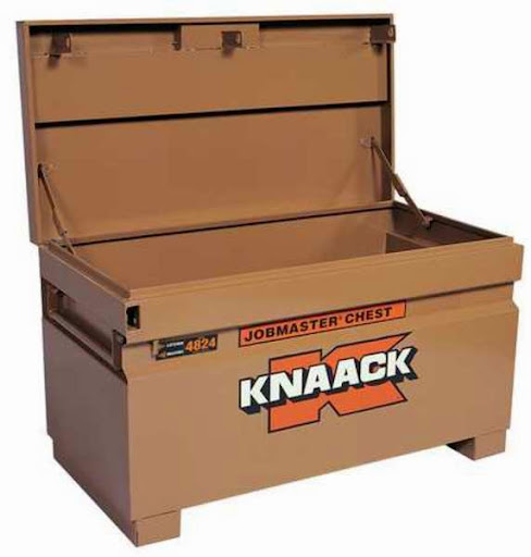
There were two of these, about where I've shown them on the linked topo map in my first post. I was in a flat area just east of the two tool boxes. I could see the closer tool box quite clearly. Maybe I was 30 yards away. I was above the trail even though the topo map shows the trail higher than where I was. The topo map is wrong in that aspect.
So, the references are:
1. Just east (30 yds?) of the two big Knaack boxes.
2. Above the trail.
3. In a flat area (basically a camp site)
4. West of the outlet of Charlotte Lake.
The ring is most likely still on top of the rock that I seem to recall that I set it on.
HJ
-
HikeUp

- Posts: 4013
- Joined: Thu Sep 27, 2007 9:21 pm
Gollum has it by now I bet.
Seriously, I hope it is rescued soon.
Seriously, I hope it is rescued soon.
-
Tom Kenney

- Posts: 386
- Joined: Sat Sep 29, 2007 7:51 pm
Hi, Jim...
Try posting at SummitPost, in the CA forum. Lots of locals on there, and maybe someone would be willing to run a mission for you. If you don't have an account, I can post a link to this thread if you'd like.
Good luck!
Tom
Try posting at SummitPost, in the CA forum. Lots of locals on there, and maybe someone would be willing to run a mission for you. If you don't have an account, I can post a link to this thread if you'd like.
Good luck!
Tom
-
Hikin_Jim

- Posts: 4688
- Joined: Thu Sep 27, 2007 9:04 pm
Ah! Now, I hadn't thought of that. I've posted stuff on the local LA forums, High Sierra Topix, Facebook, etc., but SummitPost hadn't occurred to me. Thanks for the suggestion.Tom Kenney wrote: Try posting at SummitPost, in the CA forum. Lots of locals on there, and maybe someone would be willing to run a mission for you. If you don't have an account, I can post a link to this thread if you'd like.
HJ
-
Hikin_Jim

- Posts: 4688
- Joined: Thu Sep 27, 2007 9:04 pm
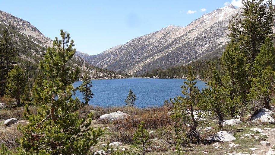
If anyone is headed out in the vicinity of Charlotte Lake this weekend, please keep an eye out for my ring. 
Thanks,
HJ
Thanks,
HJ
-
Hikin_Jim

- Posts: 4688
- Joined: Thu Sep 27, 2007 9:04 pm
A PCT Through Hiker that I know just looked for my ring earlier today, but he didn't find the two large jobsite type tool chests. It occurs to me that maybe I just got lucky with spotting them in the trees, so I wrote up a hopefully better, more detailed description below. I hope this is clearer. Feedback welcomed.
MORE DETAILED DESCRIPTION:
If one were walking west on the trail along Charlotte Lake, one would first come to the ranger station, then to the NPS bear locker, and then to the west end of the lake. As the trail draws even with the west end of Charlotte Lake, it is some distance away from the outlet stream. As the trail proceeds further west, it turns a bit to the left (~SW) and comes closer to the outlet stream. If one looks to the right (~NW), there is a bit of a rise with a pretty faint use trail going toward it. If one were to follow this faint use trail, there is a flat area, suitable for a large group to camp in on a sort of bench type area that is just above and slightly to the north of the Charlotte Lake trail. West of this flat area there is a bit of a rise, the crest of an indistinct ridge. In an cluster of trees more or less on the crest of the indistinct ridge are two large jobsite type tool chests. The brand name "Knaack" can be seen on at least one of the tool chests. These tool chests are similar in size to a NPS bear locker but are a bit lighter in color. The eastern most of these two tool chests can be seen from the above described flat area but most definitely cannot be seen from the Charlotte Lake Trail. I lost my ring in the flat area just east of the two tool boxes, perhaps 30 yards east, perhaps a bit less. As I recall, I set my ring on a rock that might have been about 18 to 24 inches in height while I washed up. I have revised slightly my topo map of the vicinity; I have now sketched in the faint use trail using yellow dots. Note also that the tool chests are on the crest of the indistinct ridge (placement approximate) and that the lost ring location is just east of the tool chests.
HJ
-
Hikin_Jim

- Posts: 4688
- Joined: Thu Sep 27, 2007 9:04 pm
UPDATE 7/6/2014: My ring was found by JMT through hiker Tim. Thank you to all who searched (especially Tim!).
HJ
HJ
-
Mike P
- Posts: 1005
- Joined: Tue Oct 02, 2007 10:48 pm
Good for you, Jim! Are you allowed home now?
-
tekewin

- Posts: 1344
- Joined: Thu Apr 11, 2013 5:07 pm
Congrats, Jim!
I'd say you beat the odds. Glad it was a happy ending.
I'd say you beat the odds. Glad it was a happy ending.
-
Hikin_Jim

- Posts: 4688
- Joined: Thu Sep 27, 2007 9:04 pm
Yeah, talk about your long shots.
Tim, the guy who found it, isn't done with his JMT hike yet (probably Wednesday), so I don't have it in hand yet. Hopefully it continues to work out.
HJ
-
Uncle Rico

- Posts: 1477
- Joined: Thu Mar 20, 2008 7:48 pm
Wow, congrats. Needle in haystack. You must be living right Jimbo.
-
Hikin_Jim

- Posts: 4688
- Joined: Thu Sep 27, 2007 9:04 pm
I wish. But God smiles upon whom he smiles.Uncle Rico wrote: You must be living right Jimbo.
We had a collision with a deer while we were on vacation last week at 70 mph at 2:00 A.M. People die in such things and/or vehicles get totaled. I lost a right side mirror. All things considered, that's a pretty good outcome.
Maybe I should buy a lottery ticket...
Of course the real "luck" is the gal I get to be with every day:
And the fact the we are blessed to have a daughter:
HJ
-
Hikin_Jim

- Posts: 4688
- Joined: Thu Sep 27, 2007 9:04 pm
I found the lower section of a BD Trekking Pole (including the tip) at the Mt. Waterman Trailhead on Saturday. Well, the use trail trailhead I should say, not the crappy official trail head that is so oddly placed further up the road.
Let me know if you lost it.
HJ
Let me know if you lost it.
HJ
