Not the whole JMT, I entered from Onion Valley over Kearsarge Pass.
Since I missed out on the lottery in February, I looked into alternate trails. I had mentioned someday going in from the West, so this was apparently the year for it. I found an exit permit for July 27 and then an Onion Valley entrance for July 23, and started making plans. I've backpacked a few times, but never anything this far on an unfamiliar trail. However, it is the JMT so lots of information is available….
Day 1: Drove up to Lone Pine on Monday, getting a nice truck wash due to heavy rain in the stretch from Olancha to the Visitor's Center. I had looked at the weather again that morning, and things were expected to clear up a little by Wednesday. That turned out to be a little wrong, but part of the adventure. Monday night we all got some rain, so the next morning began with drying things out before repacking.
Day 2: I managed to hit the trail at 8am, and soon after was feeling the extra weight on my back. But the familiar route to Kearsarge Pass was nice and cool with little sunshine, and plenty of other people were on the trail for conversation and a chance to grab a little standing rest. The view from Kearsarge is one of my favorites - it shows pretty much everything good about the Sierras with the high peaks, blue-green lakes, pine trees and amazing blue skies. All but the last part happened today… I had five days to travel, but felt good enough to push on until just below Forester Pass, a total of 13.5 miles for my first day out.
Day3: More drying out the next morning, but once on the trail to Forester I realized I might be a little tired already. However, I took a standing break every other switchback and just kept walking up, finally reaching that rocky pass. Seems you can almost see forever from up there, the vistas both North and South are tremendous. But I was certainly feeling the effects of the elevation, which is a little unusual for me - I don't normally get that until nearly 14,000 feet but I didn't do my two full days of acclimation first. This year there isn't much water between there and Tyndall Creek, but I found a little spring before the Lake South America junction. Was great to sit on the grass and relax for a while, just what I needed at the time. I camped on the high spot just above Wallace Creek, and got to watch a little bit of sunset in between the clouds.
Day 4: After filling up on water, I stopped again near the Crabtree Meadow signs for a break, listening to the pounding noise of the new construction there. I didn't see very many people this day until I reached Guitar Lake, which seemed to just appear out of nowhere while walking past treeline. A two-hour break there was great, including some rather frigid swimming and rinsing of the clothes. Since it was still early, I headed up the trail to the spots near the MMWT junction, thinking that would be a nicer starting place for the summit on the next day. Good thing it was cool, it's tough to carry enough water for an overnight all the way up there. I actually got fixated on the trail sign and walked right past the camp sites, so had to backtrack a couple hundred yards. Once again I got to see only a short piece of sunset.
Day 5: Hikers started walking on the trail just below me around 3am, a pretty steady stream for about 90 minutes. I finally got up around 6am and hit the trail at 7. I put a trash bag over my pack and left it with about 30 others at the junction and headed upwards. After a few days at altitude, I felt really good and not carrying any weight was even better! I reached the summit just about 8:30, right when it began to snow. It was very cold and windy up there, so after a short while I retreated to the hut, where I joined up with about eight scouts from Bakersfield. We chatted for a while and then took pictures and headed back down. There was a bit of rain and plenty of wind until I got to the windows. Walking down the switchbacks, I was really looking forward to filling up on water at number 23 and then making some hot chocolate at Trail Camp. But when I got there it was raining again, so I just kept on walking. About every time I thought I might be able to stop for a while it began raining again so I just kept walking. As I reached Outpost Camp it turned into a downpour, which of course quickly drenched me. I had steady rain all the way down to the Portal, but of course the burger and beer was worth the walk.
Stuff I think of:
I was really expecting the JMT to be bigger, but it's just a single-track as far as I could see. Since it gets so much traffic I figured the walking pathway would be enough for two people side by side but it's not the case.
A guy saw me getting water out of Wallace Creek and asked me which direction Whitney was located. I saw him much later that day arriving at Guitar Lake.
Saw a guy walking his dog without a leash at the JMT junction. Big black Lab, of course the owner said she wouldn't hurt anyone. I told him dogs were not allowed in the National Park, and said m "yeah, I saw that on the sign back there"… and kept on walking.
This is an awesome walk. Sometimes in the middle of it I think about how hard it is, but I would definitely do it again.
Lots of pics:

Onion Valley trailhead.

Gilbert Lake, only about two miles into the hike.

Bullfrog Lake, just before joining up with the JMT southbound.

Following Bubbs Creek for a few miles before climbing out of this valley.

Morning routine to dry stuff out before hitting the trail.

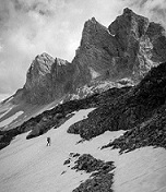
Forester Pass right of center, highest point on the PCT. This one kicked my a$$.

Looking at the trail down (southward) Forester Pass.

Break time just before reaching Tyndall Creek.

View of Whitney from Bighorn Plateau shows how massive it really is.

Alpenglow at sunset on Mt Russell from my campsite above Wallace Creek.

Leaving Wallace Creek.

Big Sandy Meadow, between Wallace Creek and Crabtree Meadows.

Timberline Lake. Could sit here and just look for hours.

Leaving Guitar Lake after food, bathing, laundry and rest.

Last big climb, glad I did this in late afternoon rather than first thing in the morning.

Did not get a lot of sunset views due to overcast weather but this was a nice night.

Morning over the Hitchcock Lakes.

Whitney summit in sight.

Sitting on top of the country. Wind chill was probably in the teens.

Looking back from the 97 switchbacks.

Bighorn Park below. Just about here it started raining much harder.

Whitney from the trail just above the Portal.

I was thinking about this all week.