
I have been wanting for at least five years to hike the Idlehour Trail but nothing about the route was particularly appealing. I would either need a car shuttle or spend a hour walking through residential neighborhoods, neither which particularly interested me. With all the conversation about the Rubio Canyon trails, I finally found my in, the Lone Tree Trail.
I started from the Loma Alta trailhead which is difficult to find unless you know where it is as you have to walk up the old driveway on the left of the house to get to an unmarked trail. I walked up the other driveway but realized where the trail had to be. From there the trail is in good shape with a couple of narrow spots. At the junction with the SCE Tractor trail, I realized that to get to the start of the Lone Tree I would have to lose altitude so stuck with the SCE route. I met my one person on this trail a hunter with a cross bow in camo, weird. This trail transitions to the next canyon over and gets a bit rough and brushy. You finally reach a cement block where you switchback up to the main ridge and the Lone Tree Trail.
From here the Lone Tree trail is in pretty solid shape most of the way. It moderates between steep and brushy but the route is apparent. I saw two clippers on the trail and at one shady spot near a rock a gallon of water for our tireless trail creator. The only spot that threw me off was where the trail does a contour to the left, right below West Fuji. the contour lasted too long and I thought it was the mine route. I turned back since I had seen a flagged route to the right but that died out. I saw a use trail going straight up the ridge and decided screw it, up I go. It was loose and gravelly but easily manageable. At the top of this spot right below the high point someone has created a stone bench with a strange balloon stick cross behind it. I don't think anyone goes here anymore but it has the best viewpoint. From there I had to bushwhack on a faint use trail to the highpoint and the register that had four entries.
The final section to Panorama Point is really close to West Fuji but has a rocky section to get over. This time I was smart and noticed that there was a cut bypassing this section, I followed it knowing that it would switchback up the ridge. Wrong! Another loose climb up some gravelly crap and some minor bushwhacking from there gained me the ridge and I was a moderate climb from the Point. From there I continued up the ridge to Muir Peak as a logical conclusion of climbing this ridge. I got to this point in exactly two hours.
From there I descended down to the fire road and passed Inspiration Notch where a couple were lolling on the benches. I finally got to the point of this hike, Idlehour Trail which first goes through a burnt section in the upper canyon but quickly turns shaded and green. The trail stays on the south side of the Eaton Canyon tributary, drops down, crosses it, climbs back up the ridge separating it from Eaton Canyon, and finally drops you into Eaton Canyon proper. Eaton Canyon at this point is dry and not very shady but as you descend down canyon it gets more and more beautiful as the stagnant ponds of water give way to flowing water and a very pretty canyon. I reached Idlehour Campground the lowest point you go in Eaton Canyon a hour and a half from Muir and took a well deserved break.
From here you get about a half hour climb out of the canyon and a fifteen minute contour back to the Mt Wilson Toll Road. You get dropped out just above Henninger Flats. I did a shuffle jog all the way down the Toll Road. I had never hiked this section since I hate fire roads and was surprised at how many people hike this ugly road up to Henninger, it was like a family reunion. I finally reached the bridge climbed up the last section to the road and then had a short fifteen minute walk back to Loma Alta and to my car. The whole hike was about 5 hours and 15 minutes and I have no patience to figure out mileage and altitude gain. Fun loop, get on it.
Lone Tree-Idlehour Trail Loop
-
HikeUp

- Posts: 4028
- Joined: Thu Sep 27, 2007 9:21 pm
Cool!
Nice loop...only recently available due to the restoration of the Lone Tree Trail. Reduces the street walking portion quite a bit compared to starting at the top of Lake Ave. Taking the SCE Tractor trail is a nice touch too, for variety!
Thanks for the trail condition update(s)! Keep 'em coming!
Nice loop...only recently available due to the restoration of the Lone Tree Trail. Reduces the street walking portion quite a bit compared to starting at the top of Lake Ave. Taking the SCE Tractor trail is a nice touch too, for variety!
Thanks for the trail condition update(s)! Keep 'em coming!
-
Sean

- Cucamonga
- Posts: 4238
- Joined: Wed Jul 27, 2011 12:32 pm
I have updated the Lone Tree trail info at Everytrail.com. There is a detailed description of the route and several pictures.
http://www.everytrail.com/view_trip.php?trip_id=1539441
There are three ways to access this trail. David described the route starting behind 1101 E Loma Alta. It is also possible to walk up the Camp Huntington Rd across the street from the Rubio debris dam. The road is technically private but nobody has ever bothered me. Just don't linger, and don't take the driveway up to the reservoir. Shortly after you reach the streambed just beyond the water company's well, find a trail on the right taking you behind the reservoir and to the unmarked Lone Tree trailhead. The third option is to begin at the Rubio right-of-way trailhead on the corner of Rubio Vista Dr and Pleasantridge Dr. Follow the path 0.1 miles to the Camp Huntington trail on the right. Camp Huntington will take you down to the Rubio streambed. Walk a few feet downstream and find the trail on the left which takes you behind the reservoir.
-
shreddy

- Posts: 241
- Joined: Sun Jan 16, 2011 10:40 pm
Thanks for both posts. Looking forward to checking out these new routes to Echo and beyond....
-
fortified
- Posts: 105
- Joined: Sat Mar 02, 2013 10:03 pm
Went up lone tree trail for the first time.....and I did everything wrong.
I am more of a trail runner, than a hiker. After running up Eaton canyon, and Echo thousands of times, and living here most of my 55 years, it was time to finally learn all the trails. Not knowing about this website until minutes ago, I looked at google earth and decided to make a go for it.
The trail looks like people must of been working there minutes before I started, about 2:30, or 3:00 pm. I don't know if tools are left on purpose, but a black plastic bag with an ax an something else was left on the trail. I never saw anyone the whole way
Somewhere between rock scramble and either at the muir x where you turn right, or just after I decided I could not go any higher. I don't scramble up loose rocks way up somewhere.(Flashbacks of Eaton cyn first falls when I was a kid)....or maybe its just me anyway.
On the way down I went on the firebreak too long and ended up in a maze of stick bushes ....don't laugh....20 minutes. It was an hour before sunset.
Was this going to be the first time after thousands of hikes I get lost?
I saw my broken earphones on a bush.......10 minutes later, my Walkman
that I didn't know i dropped was in the same place. Yep, just like on T.V. I was walking in a circle, and now with many scrapes and scratches, as I was in shorts. I don't know if anyone else has ever wandered the ( I will call it the stick maze), but their were other footprints all around in there.
After watching many stories on T.V about how people make the wrong choices in these circumstances, I realized I was starting to panic. I stopped, took a breath, and made my way up the firebreak to where I know was not off the route.
The trail was off to the west side as I remembered
This was the first time in a year I brought water, since it was a combination of warm, and an unknown trail)
Of course back down in the canyon, in the darkness I could not find the way back up the side to rubio vista, so I walked down and around.
The last fooly was....if you are in the canyon in the area the trail starts up, and it pitch black.....I was looking with my light around ands I saw two eyes reflecting back to me....large....unblinking.......I made a rustling noise, still unblinking,.....moved my light away...and oh Its something to do with the water storage, inside a gate.
-
Sean
- Cucamonga
- Posts: 4238
- Joined: Wed Jul 27, 2011 12:32 pm
Sounds like you continued down the ridge from West Fuji plateau. Some people bushwhack through there instead of taking the trail around the west slope. But it's not the easiest thing to do. I did it once or twice, before restoring the trail. Glad you made it out in one piece.fortified wrote: Went up lone tree trail for the first time.....and I did everything wrong...
-
fortified
- Posts: 105
- Joined: Sat Mar 02, 2013 10:03 pm
Sean, Thanks for the info, and pictures. Now I just feel incomplete until I make all the way around, and back down through Echo.
The reason I stopped the first time was it looked from a distance the last 10 minutes looked like it was hands and feet scrambling, close to sunset, on an unknown area, and by myself. I do remember faintly seeing what i now know must be where one goes off to the right for the Muir peak road. So, now I ask, is the last 10 minutes hands and feet or....
I also took the wrong way going up to the electric towers. Must be an old trail.
Extra credit.....Have you ever gone straight up the firebreak directly above Lake Ave? No way will I attempt the last 200 feet. But it looks like turning left at the 3060 foot level. Maybe a total of 500 feet horizontally to a little plateau on the Mt. lowe road
Thanks
-
Sean
- Cucamonga
- Posts: 4238
- Joined: Wed Jul 27, 2011 12:32 pm
fortified wrote: So, now I ask, is the last 10 minutes hands and feet or...I also took the wrong way going up to the electric towers. Must be an old trail...Have you ever gone straight up the firebreak directly above Lake Ave
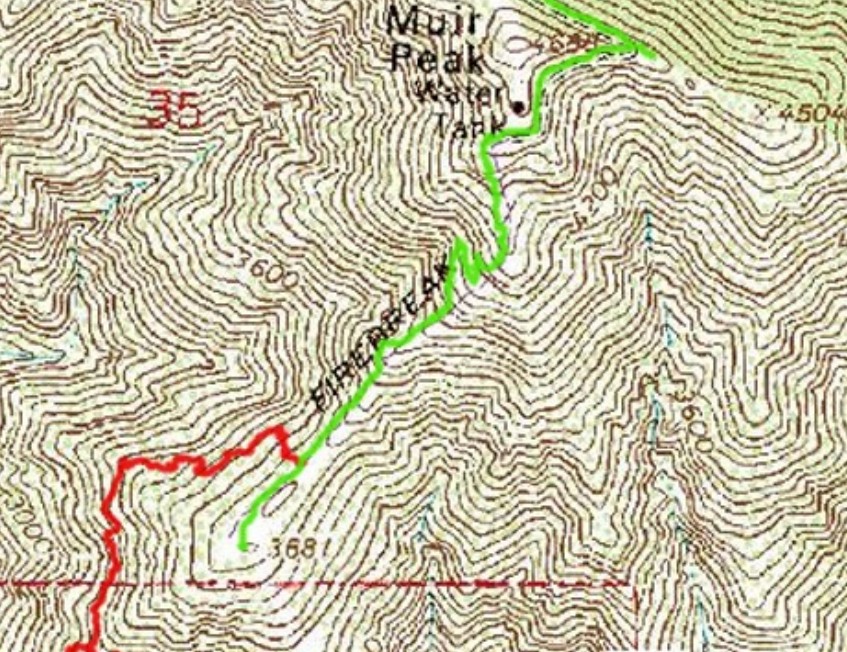
Above is a map showing the Lone Tree segment where you turned around. Notice the switchbacks before the final climb to the fire road. If you miss these switchbacks, which appear as wide, overgrown, rocky roadbeds with a sort of use trail, then you will encounter steeper scrambling going straight up the ridge. After the few switchbacks, continue along the ridgetop. You may need a hand-assist once or twice, but if you choose your route carefully, the terrain is actually pretty easy to negotiate. After the switchbacks there is one of those metal signs you sometimes find on firebreaks. Stay to the left of it.
Also, it sounds like you initially took the old SCE Tractor Road Trail up to the electrical towers. That was actually built forty years later than the Lone Tree. The tractor road was used to install the towers and hasn't been cleaned up in years, but that might change in the near future, as we are slowly trying to motivate ourselves to work on it. It goes through Pine Canyon, east of Rubio. The Lone Tree begins off of the tractor road, directly behind the reservoir, and immediately tackles Rubio's east ridge.
If you haven't done so, you could read my write-up and see a complete topo map for the Lone Tree. There is a link in my signature below.
And to answer your other question, I have taken the ridge route north of Lake. Beyond the towers you reach a relatively flat stretch right before a class 2/3 climb. You don't have to do that climb. We recently restored part of the Camp Sierra trail, which branches off to the left at the beginning of the flat stretch, curves around the head of Chiquita Canyon and connects with the Mt. Lowe fire road.
-
Ze Hiker

- Posts: 1432
- Joined: Mon Jul 28, 2008 7:14 pm
I went up once past the electric towers to the fireroad, and it was decently brushy. I think my motivation was there was an old trail here on the old historial topos.
Map / pics :
http://socalhikes.com/2009/03/double-hi ... ploration/
Map / pics :
http://socalhikes.com/2009/03/double-hi ... ploration/
-
VermillionPearlGirl
- Posts: 239
- Joined: Wed Apr 06, 2011 9:57 am
So since this thread was resurrected I was kind of fascinated by it, I didn't know there were trails on that side of Rubio at all. Decided to do a little exploring this weekend and just did Lone Tree and the Tractor trail as a loop.

J --> I --> H --> G --> H --> I --> J
The Lone Tree trail seemed in pretty good shape. But up to the towers is 1000 feet of elevation gain in 1 mile, kind of leg buster The SCE Tractor Road seemed a little rougher, with some tricky bits (I even fell down once, but the the threshold for me falling is decidedly pretty low) and a good amount of brush, but I really liked it -- it takes you out of Rubio and into the canyon next to it. New scenery for me.
Fortunately I ran into a guy on the way down who confirmed I was on the right trail and that it looped back. I have a sorry history connecting trails I've never been on in a loop. These two meet up at the towers and they're both pretty obvious. I liked taking the Tractor Road down because it wasn't as steep as the Lone Tree was up.
Going to push much further last time, I was recovering from the flu this week so the little 2.5 mile loop was just the right size. Thanks for pointing this out, seems like a great alternative to the Disneyland queue that is Sam Merrill. I like that it's so accessible, but challenging, with lots of bigger loop opportunities.
Although, it's so brushy, any snake danger in the warmer months you think? I don't like not being able to see where my feet are
J --> I --> H --> G --> H --> I --> J
The Lone Tree trail seemed in pretty good shape. But up to the towers is 1000 feet of elevation gain in 1 mile, kind of leg buster
Fortunately I ran into a guy on the way down who confirmed I was on the right trail and that it looped back. I have a sorry history connecting trails I've never been on in a loop. These two meet up at the towers and they're both pretty obvious. I liked taking the Tractor Road down because it wasn't as steep as the Lone Tree was up.
Going to push much further last time, I was recovering from the flu this week so the little 2.5 mile loop was just the right size. Thanks for pointing this out, seems like a great alternative to the Disneyland queue that is Sam Merrill. I like that it's so accessible, but challenging, with lots of bigger loop opportunities.
Although, it's so brushy, any snake danger in the warmer months you think? I don't like not being able to see where my feet are
-
Sean
- Cucamonga
- Posts: 4238
- Joined: Wed Jul 27, 2011 12:32 pm
Yes, be careful on the SCE trail. We've only just started cleaning it up, and we don't expect to reach the Pine Canyon side for awhile. You might encounter rattlesnakes and ticks. They are there. I've seen them.VermillionPearlGirl wrote: Although, it's so brushy, any snake danger in the warmer months you think? I don't like not being able to see where my feet are
-
VermillionPearlGirl
- Posts: 239
- Joined: Wed Apr 06, 2011 9:57 am
Grumble. I hate the summer.
Thanks for your trail work though!
Thanks for your trail work though!
-
phstudio

- Posts: 12
- Joined: Sat Nov 03, 2012 4:05 pm
Fantastic news about the Lone Tree Trail. The last time I was there it wasn't quite ready for prime time.
I appreciate the Every Trail link. I was never really a fan of their maps, so if you don't mind I created a map of your GPX file on Caltopo, with their new increadibley detailed and razor sharp rasters of the USSF Topo Maps. here's the link: http://caltopo.com/map?id=0F4H
I have to hit up Lone Tree in he next couple of days.
Thanks for your hard work!
-
fortified
- Posts: 105
- Joined: Sat Mar 02, 2013 10:03 pm
SEAN, Thanks for all the info. I finally made it all the way. The last 1,000 feet was mostly scrambling. I paid more attention to foot prints, and the little flags (orange), I think?
I get a bit uneasy on big cliffs, but all the climbing over the last two years, made it a go. I was just beginning the last 1,000 feet when the sun was setting, and was fully committed by then. I finished with a run to inspiration point, sunset ridge, and down through echo.
So over all, the trail up to "rock scramble" looks really good. But the 1.000 foot climb after would not be suggested like I did....by yourself the first time, while it is getting dark.
So, who is doing the actual work on the trails? And volunteering? Wow!
How about a fund raiser bbq at Farnsworth Park, and everyone can share knowledge, and stories. It would also be a good place to get some people to sign up for times and places for trail work.
-
Sean
- Cucamonga
- Posts: 4238
- Joined: Wed Jul 27, 2011 12:32 pm
Cool! Glad you made it up the last section alright. I agree, you probably want to try that during daylight on your first attempt.fortified wrote: SEAN, Thanks for all the info. I finally made it all the way...So, who is doing the actual work on the trails?...
Paul Ayers and some other volunteers, including myself, work on trails around Rubio Canyon for the Arroyos and Foothills Conservancy. I suggest contacting them if you're interested in supporting trail work. We work on Rubio every other Friday and an occasional Saturday.
http://www.arroyosfoothills.org/
-
Sean
- Cucamonga
- Posts: 4238
- Joined: Wed Jul 27, 2011 12:32 pm
Thanks! That is a much better map.phstudio wrote: ... if you don't mind I created a map of your GPX file on Caltopo, with their new increadibley detailed and razor sharp rasters of the USSF Topo Maps. here's the link: http://caltopo.com/map?id=0F4H
-
turtle

- Posts: 152
- Joined: Wed Jan 27, 2010 11:35 am
Sean, just wanted to offer my thanks to you and the other trail builders -- all your hard work is much appreciated.
I finally had a chance to check out the Lone Tree Trail this morning, and now I'm wondering why I waited so long. What a great route!
I can think of few if any other Front Range routes that match if for sustained pitch. The aggressive line it takes up an aesthetic ridge is really remarkable. Seems like I was even with Echo across the way in no time at all! The northward zig and eastward zag leading into Fuji do offer brief relief and a welcome diversion through some varied vegetation (grass, oaks). But above Fuji you're right back at it again!
In the NW facing bowl just below Fuji, I passed an orange, one-man tent surrounded by some tools. Perhaps that was you? I briefly queried with your name, but it was still early and I did not want to rouse whoever might be inside if he/she was still sleeping.
Thanks again for all your efforts...
-
Sean
- Cucamonga
- Posts: 4238
- Joined: Wed Jul 27, 2011 12:32 pm
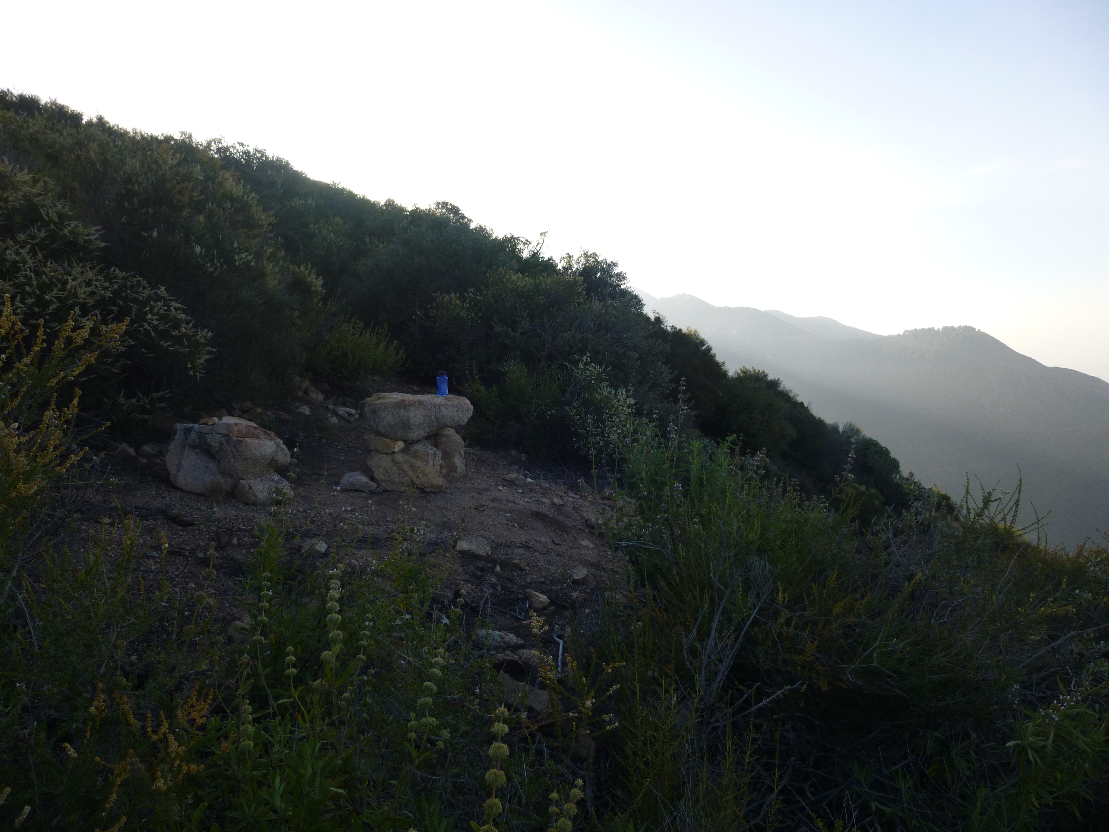
You're welcome. I'm glad you enjoyed the trail. That was my stuff you saw this morning. I hiked up yesterday afternoon to create the campsite among the oak trees. Then I chilled the rest of the evening, drank a beer, listened to the basketball game. I got up at first light and walked to West Fuji to watch the sunrise over Mt. Wilson. Then I sat on the secret bench for awhile. Didn't return to the tent until around 7AM. I guess we just missed each other. Next time I should leave a note in case someone visits while I'm away.turtle wrote: Sean, just wanted to offer my thanks to you and the other trail builders -- all your hard work is much appreciated ... I passed an orange, one-man tent surrounded by some tools. Perhaps that was you?
I plan on visiting West Fuji every Memorial Day, to celebrate the restoration of the Lone Tree Trail. It's been one year so far.
Paul's Love Nest (in the oak grove)

West Fuji - marine layer over Pasadena - sign of the Byche Mob Gang
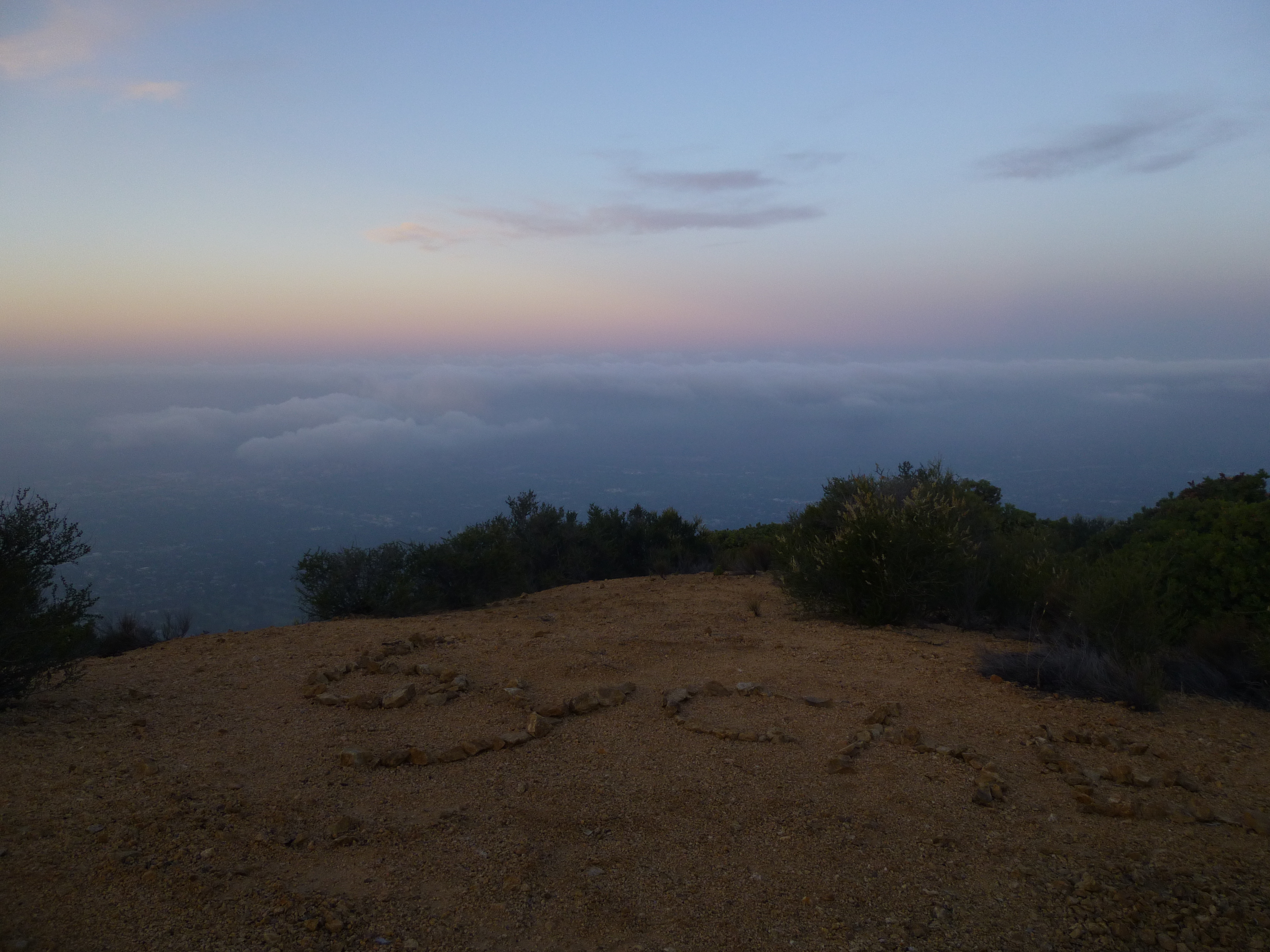
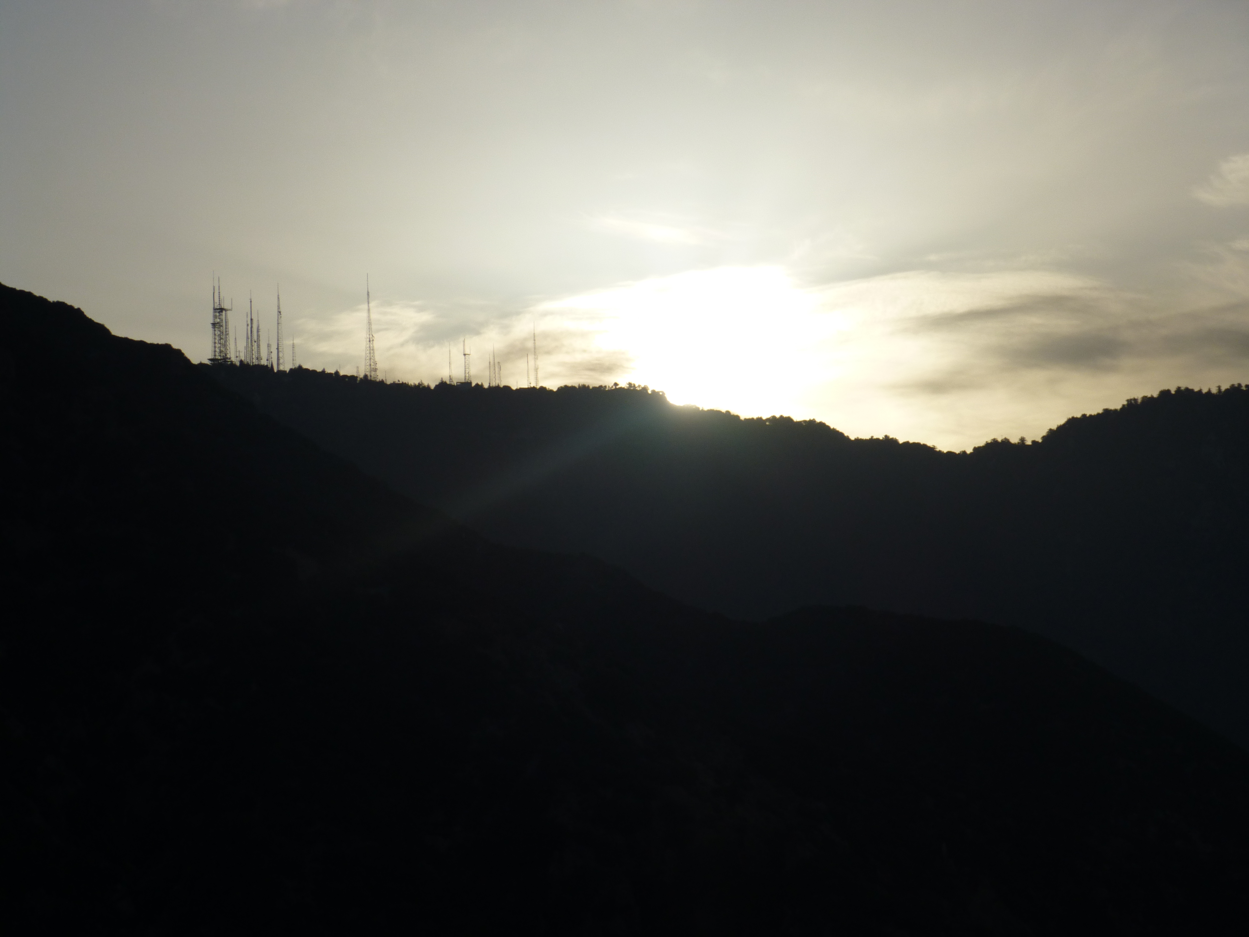
West Fuji - watching the sunrise

Sunrise over Mt. Wilson
Jesse's Secret Bench
-
walker

- Posts: 248
- Joined: Mon Apr 08, 2013 11:14 pm
I was in Rubio Canyon yesterday and noticed orange trail tape marking a route ascending through the bushes up the canyon wall to the shoulder opposite Rubio Pavillion. Is a trail being developed over there as well? I'd always assumed that that shoulder was the line the original lonetree trail took up to the ridge.
I got curious about the route of the old trails around there and stumbled across this:
http://upload.wikimedia.org/wikipedia/c ... te_Co..png
You can see in the image what appears to be one branch of the Lonetree trail switchbacking up what I assume is the shoulder opposite Rubio Pavillion, but you can also see another trail contouring up canyon towards the waterfalls along the canyon wall and yet another path cutting back towards the main ridgelline. The steep one shooting for the ridgeline might be a phone line or power lines? Does anybody know the story on those offshoots?
It was cool to see those stereo images of the area. Anybody know if more of them were shot on or around the railway?
-
Paul Ayers
- Posts: 50
- Joined: Fri Sep 14, 2012 5:21 pm
Hi-I've been fooling around with this trail system, which I call the Lone Tree-Pavilion (“LTP”) trail system, for just under 20 years. In 1994 and 1995 I mapped a number of lost 19th century trails in Rubio; the 1993 Kinneola Fire had revealed trail beds which I could follow and flag. These included the Lone Tree, the Old Echo Mtn. and one lower segment of the LTP system running from the Lone Tree to the discharge reservoir below the Pavilion. This lower segment was included in the very first trail map I drew of Rubio in 1995. (See, below)

During the time I was building the Incline Trail, 2005-2008, I spent a lot of time looking at the east wall of Rubio Canyon. I kept seeing trail patterns. I did some exploring and found a number of trail fragments including one that ran all the way to the lower of the three upper switchbacks of the Lone Tree. But it was not until the photo you posted surfaced about two years ago that I had some historic record of the trail. The best resolution copy I have found is from the UC Riverside collection; you can clearly see the upper two switchbacks of the Lone Tree in the upper right hand corner. (See, below)

I have just roughed in a through route from the Lone Tree to the Pavilion. I am not sure what I am ultimately going to do with the trail; the system is quite extensive as you can see from the photo below.

A SERIOUS WARNING-if you go wandering around in this area be very careful there are some major drop-off of up to 100’ that will come upon you suddenly
Best
Paul
-
walker
- Posts: 248
- Joined: Mon Apr 08, 2013 11:14 pm
Wow, Paul. Thank you so much for sharing the results of your experience and research and for all of your work making access to that area possible.
It's remarkable how the fire cycle can expose pieces of history thought to be "lost" but basically still there underneath the chaparral.
A few years ago, a fire near the Cobb Estate revealed the track of what I guess was the Camp Sierra trail in pretty good shape. After the Station Fire, I followed the remains of a trail that switchbacks up the side of the Arroyo Seco from cabin ruins near Gold Mesa CG.
It's remarkable that these historic routes have been neglected since the Great Hiking Era. Especially since with a bit of basic maintenance, they might still be viable. In the meantime, firebreaks, debris basins, access roads and private residences have been constructed on top of them, effectively turning the foothill area into an industrial buffer zone or shutting down access entirely. Perhaps restoring some of these trails and reclaiming access to the foothills can help the region get back in touch with where it is situated, where it's been and where it's going.
-
Paul Ayers
- Posts: 50
- Joined: Fri Sep 14, 2012 5:21 pm
Dear Walker-Thank you for your kind words. I have actually done some work on the Camp Sierra but that is a little off-topic for this thread; will start another on it at some point. I too saw the trail from Gould, but from the other end at Starlight Drive. They fenced it off about 2 months after the fire but I did some exploring and have a few pics I will probably post as well.
Here are a couple of shots from my first trip down the Lone Tree on 5-30-1992. I had been doing a lot of restoration work on Echo Mountain and could see the trail portions and decided to explore; my companions were Nancy Yeo and Margo Reynolds. Here is Nancy (l) and Margo at West Fuji

I completely missed the right turn down into the Oak Grove and we went right off the end of West Fuji. It was a little scrambly but near the Summit Mine we hit the cross trail and found our way west to the Lone Tree. Here is a picture of our scramble.

Best
Paul
Here are a couple of shots from my first trip down the Lone Tree on 5-30-1992. I had been doing a lot of restoration work on Echo Mountain and could see the trail portions and decided to explore; my companions were Nancy Yeo and Margo Reynolds. Here is Nancy (l) and Margo at West Fuji
I completely missed the right turn down into the Oak Grove and we went right off the end of West Fuji. It was a little scrambly but near the Summit Mine we hit the cross trail and found our way west to the Lone Tree. Here is a picture of our scramble.
Best
Paul
-
fortified
- Posts: 105
- Joined: Sat Mar 02, 2013 10:03 pm
I notice one of the original posters last year said they shaved of time by starting his loop near the lone tree trail start, instead of Lake ave. However You can continue down from the Sam Merrill trail, through the wash, and exit on Rubio canyon. Its just a few minute long.
-
David R
- OG of the SG
- Posts: 622
- Joined: Sun Jun 12, 2011 10:28 pm
Second time up here, this time parked off of Huntington Drive and went into Rubio Canyon. Took the left fork and connected to the main Rubio trail. I got to the ruins of the Pavilion and took the butt ugly trail up to Echo Mountain. The trail is narrow and eroded at spots just like me so I enjoyed its dubious mug. The only section that may give you pause is a small rock scramble that may be able to be bypassed on the left. To the right there is some great air, into a gully. Once you get above the gully the trail contours to the right on to the luscious bump of Echo. From here it is a bit brushy and kind of boring as you switchback up very gently to the top. The top was covered with the scourge of the earth AKA the weekend hikers. I even got forced into taking a picture of a group of whiny sniveling ones, I almost egested my lunch.
From here I took Castle Canyon which is just an awesome trail and there were even some hot young things to look at on the way up. I finally got to Inspiration Notch and left the hordes as I went to Muir Peak. There I had some solitude and took my first rest, two hours from the start. I descended to Panorama Point and was surprised to see some hikers on the ridge leading to that point relaxing. On the way down to W. Fuji I was even more surprised to meet a hiker and his dog coming up LT. He had a bottle of water and was just kicking it, I love these type of guys. The way down to Fuji is steep, loose, and full of yucca also known as shitty. Fortunately it is short and before you know it you're Fujiing. That sign in book is sure damn full I was the third signature the first time up and now over 3/4 of the book is full.
From here to the bottom, the trail is noticeably improved. You can even jog some sections. A quick right at the bottom gets you back into Rubio canyon. I did notice what appeared some work on the east side of Rubio Canyon from this trail not sure where that is supposed to go. A nice loop in 3.5 hours I appreciate all the new trails and variations.