
The Tom Harrison Baldy Map? Thinking about picking it up because there are some peaks / trails in the area I want to explore.
If you have this map would you say it is pretty comprehensive of the trails in the area?
Tom Harrison - Baldy Map?
-
blueshammer
- Posts: 105
- Joined: Wed Nov 25, 2009 1:03 pm
I have the Tom Harrison Angeles High Country Trail Map. It covers a broad area, from the San Gabriel Wilderness to the Cucamonga Wilderness. Just about all the trail info in the Baldy map is present in the High Country map.
http://www.tomharrisonmaps.com/ANG%20Web%20Map.gif
To me, the Baldy map, while more detailed, isn't really necessary.
http://www.tomharrisonmaps.com/MB%20Web%20Map.gif
http://www.tomharrisonmaps.com/ANG%20Web%20Map.gif
To me, the Baldy map, while more detailed, isn't really necessary.
http://www.tomharrisonmaps.com/MB%20Web%20Map.gif
-
Breabonnie
- Posts: 50
- Joined: Fri Jan 13, 2012 11:18 am
Hi there,
A map is always a good idea, but its also helpful to "know before you go" on hikes. If you look up recent reports on www.localhikes.com using this link for the LA/Riverside/OC area: http://www.localhikes.com/MSA/MSA_4472.asp
then you can see what the most recent trail conditions are if you click on the name of the hike you might consider doing. (The reports are listed by date once you click on the name. There you get helpful info ie: "over grown chaparral bushes blocking path" for instance, "washed out/lost trail" areas, hard to find areas with details to help you not get confused, "new rattle snake infestation" in spot, or "new burned out areas" etc.) and photos from some hikers ...recommendations and corrections or things to look for, helpful hints or creative changes to some hiking trails.
I had been up to Baldy last summer and enjoyed the three Tee's hike as a loop hike to hit all three Tee's in one hike for instance. I took a "short cut" to make the hike a more pleasant 10 mile loop by taking the ski lift in both directions (up from and back down to parking lot) (Note: ski lift is only open Fri-Sun http://www.mtbaldyskilifts.com/).
There are some insider tips on how to save on ski lift prices for the savvy coupon hunting local (like myself -check out https://www.getfreeticketshere.com/).
Then you have money to spare to use at the one restaurant "Top of the Notch" (casual but great scenic views). Its also the only place to buy food from once you ride the ski lift to the top. So pack your own food or eat in town before you get on the ski lift or just eat at the " Top of the Notch".
Mt. Baldy - its hot during summer even at high elevation and most hikes have little to no shade...so water, water and more water is key...sun screen and hat are helpful too. There are no outhouses. Just the restroom at the parking lot at bottom of ski lift and one at the "Top of the Notch" restaurant.
Advise: Cooler temps early AM are very pleasant to hike in. Temperature change will vary in shade and at higher elevation and also early morning...a very light jacket for slightly cooler temps is helpful at times, but you'll want to tie it round your waist as you heat up and then perhaps put it on again when you reach a cooler section of shade or windy conditions.
I advise hiking poles for most Mt. Baldy hikes due to the steep and rocky terrain. Its hard on the knees coming down and I don't like to carry things, but I'm grateful on the way down for a hiking pole, especially on the rocky trails where its easier to stumble on the tons of loose rock laying around.
I think I read somewhere that there might be a parking fee at Mt. Baldy parking lot now. That would be new. Anyone else know anything about that? Well, perhaps just check the link to the Mt. Baldy ski lifts that I have posted above and see what you find on that.
Happy Trails!
BreaBonnie
-
shreddy

- Posts: 241
- Joined: Sun Jan 16, 2011 10:40 pm
This is great info. I am only familiar with the Mt, Baldy Run to The Top trail. Have always been intrigued by the other trails up there and the surrounding peaks .. Thanks!
-
Sean

- Cucamonga
- Posts: 4251
- Joined: Wed Jul 27, 2011 12:32 pm
I purchased the Angeles High Country Trail map. I do a lot of off-trail stuff and like to have a detailed topo map for reference. But if you simply want to know what the trails are, the Forest Service recently put up a perfectly good trailhead map at San Antonio Falls Rd.
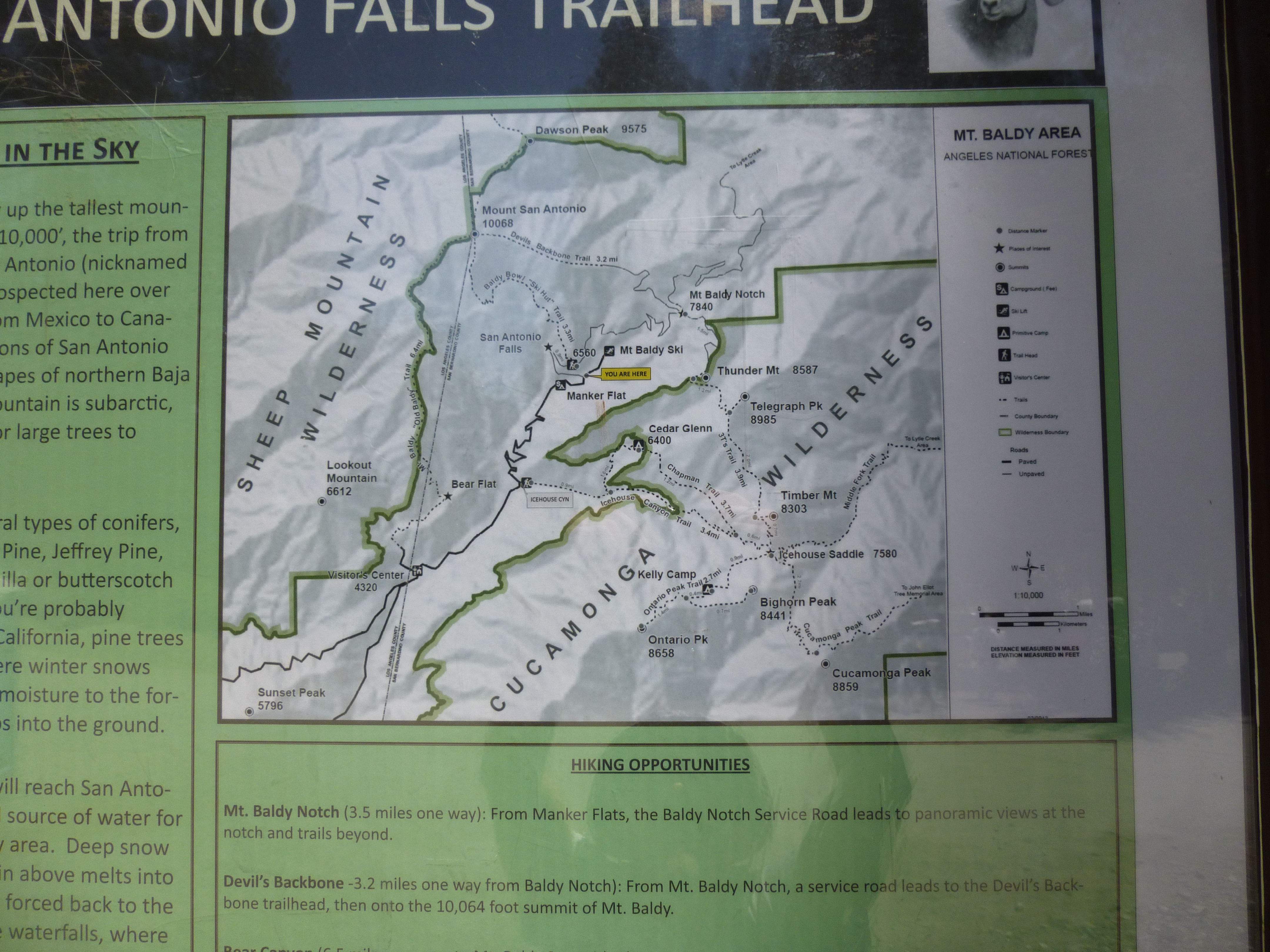
They don't include the semi-popular Register Ridge route or the Lookout Mtn trail, but neither does Tom Harrison.
P.S. The FS map is also missing labels for Mt Harwood, West Baldy, and Sugarloaf Peak. So the Harrison map is superior in that regard. There are well-established use trails to Harwood and West Baldy. Sugarloaf is steep cross-country scrambling.
http://angeles.sierraclub.org/hps/guides/17a.htm
-
Hikin_Jim

- Posts: 4688
- Joined: Thu Sep 27, 2007 9:04 pm
I like the Angeles Front Country and Angeles High Country maps. Those two maps basically give you the entire Angeles National Forest. They're great for pre-trip planning, and they're fine generally for on-trail hiking. I prefer the more detailed USGS topos for off trail/sketchy trail hiking.
All of Harrison's maps are the same price (about $10). I'd just get the two main maps (Front Country and High Country) and be done with it.
HJ
All of Harrison's maps are the same price (about $10). I'd just get the two main maps (Front Country and High Country) and be done with it.
HJ
-
Phil B
- Posts: 101
- Joined: Wed Oct 03, 2007 12:47 pm
I go along with that HJ, and personally, I have always felt that USGS 7.5 topos are the favourite when off trail or in remote areas. At about 6/7 bucks apiece thats cheap insurance for something that can get you out of a though situation. Of course, you also need the orientation skills to go with it.
Phil
Phil
-
shreddy
- Posts: 241
- Joined: Sun Jan 16, 2011 10:40 pm
Have both the front & high country San Gabe Harrison Maps. They're great!
-
Hikin_Jim
- Posts: 4688
- Joined: Thu Sep 27, 2007 9:04 pm
Oh. Well, if you've already got those two, there's really no reason to get Baldy unless you just want it for the sake of convenience.
HJ
HJ
-
Sean
- Cucamonga
- Posts: 4251
- Joined: Wed Jul 27, 2011 12:32 pm
They were charging $5 on the weekends during snow season. I haven't noticed them doing it the rest of the year. Maybe on special event days.Breabonnie wrote: I think I read somewhere that there might be a parking fee at Mt. Baldy parking lot now. That would be new. Anyone else know anything about that?
-
Phil B
- Posts: 101
- Joined: Wed Oct 03, 2007 12:47 pm
I know that the last two weekends the Parking lot at the Ski lift was charging $5.00 a car, did'nt think they did that out of ski season.
-
Breabonnie
- Posts: 50
- Joined: Fri Jan 13, 2012 11:18 am
Thanks for the parking info guys. Good to come prepared for it just in case.
-
Sean
- Cucamonga
- Posts: 4251
- Joined: Wed Jul 27, 2011 12:32 pm
According to their website, it now costs $5 to park from 6AM-11PM, $10 for 24-hours, and $30 for a year pass. But there is no fee for people with an Adventure Pass, Season Pass, or Club Baldy membership.Phil B wrote: I know that the last two weekends the Parking lot at the Ski lift was charging $5.00 a car, did'nt think they did that out of ski season.
http://www.mtbaldyskilifts.com/rates.php
-
JeffH

- Posts: 1352
- Joined: Sun Nov 28, 2010 7:09 am
I just parked there on Friday night (TR coming....) and didn't see anything about a charge. Now I'll have to go back and look!
"Argue for your limitations and sure enough they're yours".
Donald Shimoda
Donald Shimoda
-
Uncle Rico

- Posts: 1481
- Joined: Thu Mar 20, 2008 7:48 pm
FWIW, when I was there in early May, there was a dude collecting the $5 fee as you approached the main parking area. He was gone when we came down late in the afternoon.JeffH wrote: I just parked there on Friday night (TR coming....) and didn't see anything about a charge. Now I'll have to go back and look!