
I have seen the beginning of this journey called "Bastard Ridge". Kind of a coincidence since I kept blurbbing out "son of a bitch" the whole way. This was the first time for me, and was not sure what I would come across.
As usual, I made some basic mistakes. Tennis shoes with completely worn out soles, left cell phone at home. For me there was no way I would take this route back down, so I was quickly dedicated to 2,700 ft climb 1/2 of which was rugged ridge climbing.
Anytime I start talking out loud to myself on a trail, I know I am on one I wish I never started. This is where I came up with the "S.O.B". trail.
CAUTION: The last part, your final assault to Mt. Wilson toll, the metal cable someone put for assist. is frayed a bit, and has VERY SHARP bits of metal protruding. Serious hand damage if you are not looking. Also when I set my bag down on the toll road......are those ticks that are clinging on for the ride? Looks like ticks.
Maybe most of you do these hikes a lot, but it was about as rugged as I ever want to get. Some points you are on all fours with nothing stable to kick off from. But then hiking alone, an hour before sunset, with no cell phone, at 56 years old makes this journey......um.. interesting.
The fun part was the 13 miles back. Yep, the toll road for seven miles down, and then 5 or 6 miles from Altadena to my car in Sierra Madre.
Jones peak to wilson toll from sierra madre
-
mcphersonm80

- Posts: 243
- Joined: Mon Aug 23, 2010 11:46 am
Love that route. 
You're right about that metal cable, seems like it'd be a nice aid until you grab it in the wrong spot. I don't bother with it. And I've also noticed an abnormal amount of ticks this year, usually in the areas overgrown with mustard flowers... 'tis the season, I suppose.
A nice alternative to coming down Bastard Ridge is either the Bailey Canyon Trail or the Connector Trail down to the regular Mt Wilson Trail. Both add a little distance, but the trails are a cakewalk compared to that crumbly ridge.
-
fortified
- Posts: 105
- Joined: Sat Mar 02, 2013 10:03 pm
Mcphersonm80
Yeah, I thought about the options I know the Wilson trail meets the Toll road, but not sure about a connector. Is this "connector" different than the actual trail?
The Bailey. I have never been on that one. I saw the trail but did not know where it went, and did not want to compound the problem as the sun already set as I reached the toll road.
Also, open question for you and anyone. On the ridge hike as described, I think the purple flower are not the same as the poisonous Itchy ones. Right?
-
mcphersonm80
- Posts: 243
- Joined: Mon Aug 23, 2010 11:46 am
Both the Bailey Canyon Trail and the Connector Trail branch off of the route you took just north of Jones:fortified wrote: Mcphersonm80
Yeah, I thought about the options I know the Wilson trail meets the Toll road, but not sure about a connector. Is this "connector" different than the actual trail?
The Bailey. I have never been on that one. I saw the trail but did not know where it went, and did not want to compound the problem as the sun already set as I reached the toll road.
Also, open question for you and anyone. On the ridge hike as described, I think the purple flower are not the same as the poisonous Itchy ones. Right?
-Bailey heads west just after the little scramble down to the saddle from the top of Jones. It's very well maintained, easy to follow, and not particularly steep. Descending this trail approx 3.5 miles would put you at Bailey Canyon Park in Sierra Madre, leaving you with a 3/4 mile walk back over to Mt Wilson Park.
-"Hiker Bob's Connector Trail" branches off a bit north from there and from a slightly higher elevation, and is a signed junction. It switchbacks down to the east and joins the main Mt Wilson Trail near the helipad. Descending this trail will put you right back where you started.
Both are very well maintained and easy to follow, and make excellent routes to loop together with Bastard Ridge (because like you mentioned... descending that would suck)
Regarding the flowers, there is no Poodle Dog Bush on that route. Right now, purple sage is blooming abundantly and the lupine may also be starting to flower, and there's a TON of that on the stretch between Jones and Hastings (pic below). Also some wild snow pea with purple flowers, but nothing poisonous.
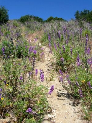
Lupine between Jones and Hastings, June 2012