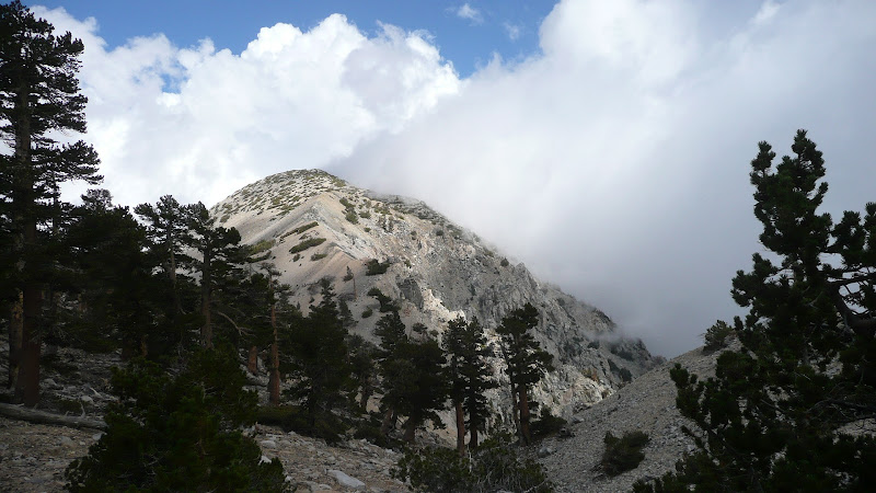
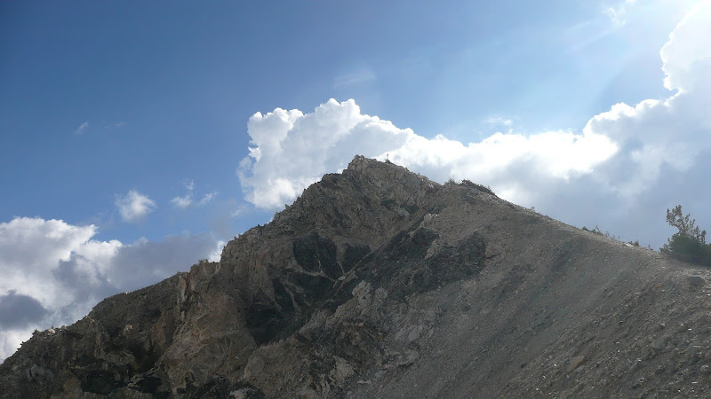
I did a multi-day backpacking trip last week in the San Gorgonio Wilderness. For day one, I did an ascent of Bighorn Mtn (10,997') and the Dragon's Head (10,866'). If you're interested, you can check it out on my TR on my Hikin' Jim blog.
Outstanding trip report Jim,
You know it never occured to me until I read your blog,.
that there are 24, 10 K peaks in socal, after thinking about it I realise that I have only done half of them. So now I have another goal, to tag all 24.
I assume you took the trail head off of Jenks Lake Road, looking at the map to reach Dragon Peak and then get back to your campsite was a pretty though days hike. Did you camp at Trail Flat or Lodgepole spring campsite, either way that must have been about 17/18miles round trip. Thats one great first day out on the trail.
Thanks, guys. It was a really fun trip; one I've been wanting to do from as far back as 2006.
RichardK wrote: Excellent blog and trip report. It made me feel that I was there with you.
Thanks, Richard. That was actually what I was trying to do. I wanted to walk the reader through the hike, showing the terrain and scenery as well as discussing why particular points were important to the trip. Hopefully you got some insight in to the trip as well as some nice wilderness shots.
Phil B wrote: Outstanding trip report Jim,
You know it never occured to me until I read your blog,.
that there are 24, 10 K peaks in socal, after thinking about it I realise that I have only done half of them. So now I have another goal, to tag all 24.
I assume you took the trail head off of Jenks Lake Road, looking at the map to reach Dragon Peak and then get back to your campsite was a pretty though days hike. Did you camp at Trail Flat or Lodgepole spring campsite, either way that must have been about 17/18miles round trip. Thats one great first day out on the trail.
Cheers
Phil
Hi, Phil,
Yes, I came in from South Fork off of Jenks Lake Road. I didn't calculate the exact mileage (difficult to do with XC trips), but I assumed it had to be in the high teens. My evening's camp was in the Lodgepole area.
It was a big first day. I was tired the next morning, so I slept in until 0630. I paid for that a bit later in the day, but it worked out. Look for a future post on the subject.
Great blog and trip report Hikin Jim!! You do certainly have a knack for narration. I am anxiously awaiting your next installment of the trip and of future trips. I, like you, have young kids and don't get out as much these days so it is always nice to live vicariously through other people's trip reports.
Question. You mention that you followed an old mining trail (lodgeople trail I think), but does that trail lead to any mines in that area? Forgive my ignorance, but I cannot recall anyone mentioning any mining history in that area. Inquiring minds want to know
If you look at a map of the area, you'll see that Mineshaft Saddle lies along my route. To the east of Mineshaft Saddle is Mineshaft flats, reportedly the site of an old mine. I understand that you used to be able to see some remains from the mining operation, but when I've looked around, I haven't seen anything. It's really sandy there. Sandy soil tends to fill in shafts quickly.
Scott Gardner (February 11, 2006) stated that all that remains of the mine at Mineshaft Flats is a small (approximately 10 feet x 10 feet) depression, and a few timbers
I'm not sure who Scott Gardner is, but it sounds like a first hand observation and is consistent with what I know.
Here's a link to the approximate position of the mine: