
Winston Ridge - Middle Little Rock Creek
-
Elwood

- Posts: 622
- Joined: Fri Aug 15, 2008 5:23 pm
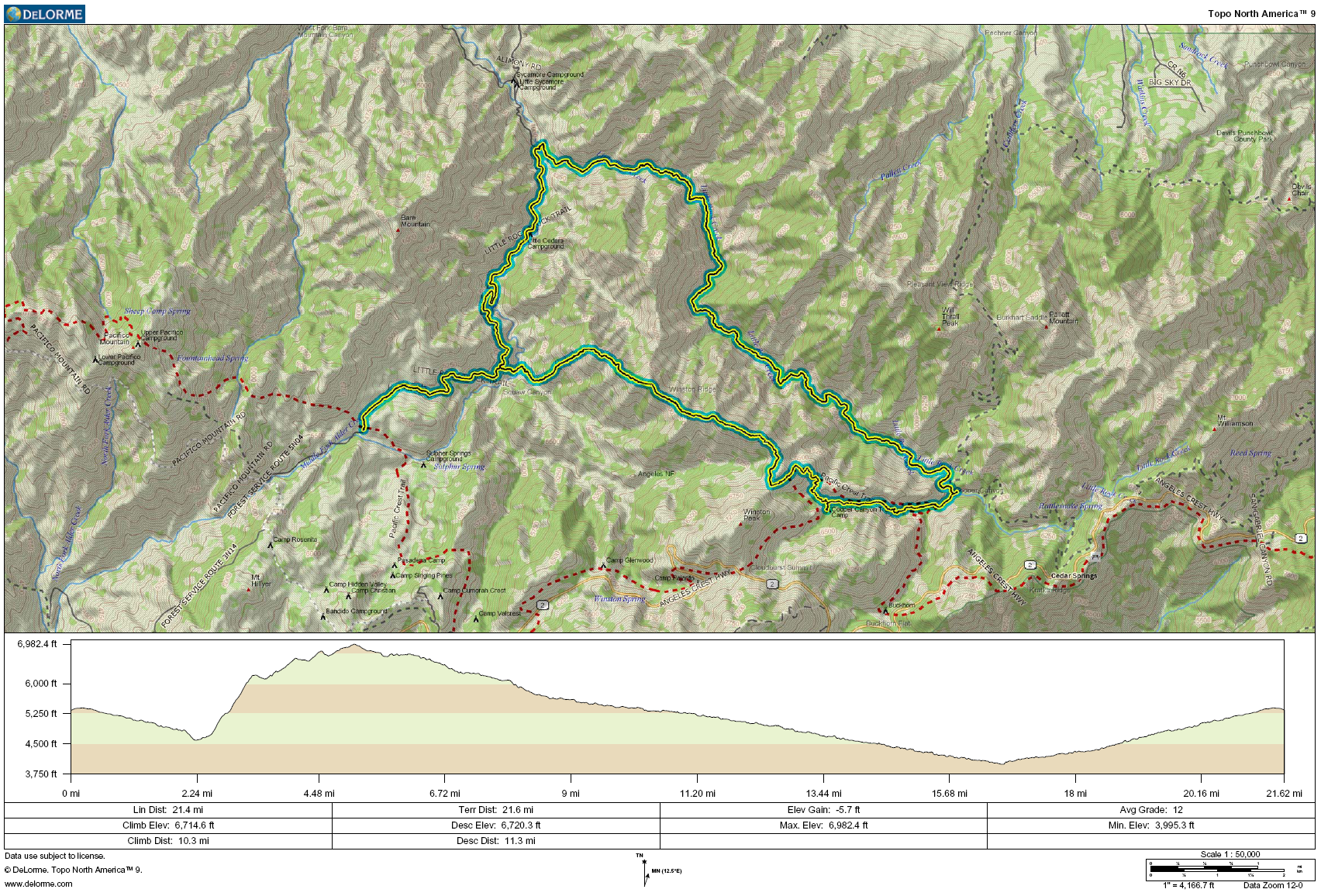
0400 Saturday morning I met the good Dr. Turtle along SR 2 in La Canada- Flintridge. We drove the Jeep to the closed gate on 5N04.4 near Pinon Flats / Sulphur Springs. We were on the hoof at 0500 headed towards the western toe of Winston Ridge. Turtle and I had scouted the route from satellite imagery and GPS tracks from my previous excursions through the area. We had ascertained that the most satisfactory route towards Winston Ridge would begin at one of bends in 5N04 after it turns northward past Pinyon Flats. We had to pick up around 1,600 feet from the creek bed to reach the ridge on Winston. This climb was pretty energetic due to the steep and sandy terrain. We topped out right on schedule, before the sun could start baking us. The western third of the ridge had suffered badly during the 2009 conflagration. Consequently the preferred route was covered in turricula. Turtle traversed the steep, loose north slope, while I opted for the poodledog-covered ridge top. I figured that I might stop itching long before recovering from the results of a misplaced foot. To each their own. Traversing the unburned part of Winston Ridge was pleasant and uneventful. It is mostly good trail with a few climby and brushy spots thrown in to keep it interesting. This trail wraps around the 6,903 foot bump before joining the Pacific Crest Trail down to Cooper Canyon Trail Camp. Turtle and I grabbed a few liters of water at Cooper, then headed eastward towards our drop-in point along Little Rock Creek. We accidentally overshot this waypoint, having realized this when we got to the Eagle's Roost trail cutoff. Just past the drop-in, we stopped for a snack, and replaced the (totally palatable) Cooper water with aerated, running water from a more energetic source along Little Rock Creek. The ~ 7.7 mile trek from here to the exit point a ways north along 5N04.3 was very pleasant. Typical of our canyons, it was mostly rock-hopping, a few easy down-climbs, and route-finding along numerous benches. Our dry winter probably made this a lot safer and easier than this major mountain drainage would normally otherwise represent. There were fish and frogs in most of the bigger pools along the way. As expected, we encountered a couple of rattlesnakes along the way. Both of them were too cranky to have their pictures taken. Bear scat was abundant along the entire route. Flying bugs were just awful. Turtle managed to inhale a few, and I could barely keep them out of my eyes. This was problematic, while constantly trying to aim my steps towards the next stable rock. It was very hot in the canyon bottom, over 90F according to my not-excessively-accurate pack thermometer. The net hat was out of the question; we just suffered through the buzzing tormentors. We availed ourselves of good water for most of the segment. Things started getting stagnant or dry for the last few miles though. We made better time through the canyon than expected. Drop-in to exit took around 6:30. The five mile slog back up the road to the car was a bit tiresome. We were both dreaming of the four liters of water I had on ice in the Jeep. I can't recommend this hike to any but the most considerate, experienced local hikers. There are few practical escape routes for tired or injured trekkers. This area is so beautiful and appears to be so unused that it would be shameful for it to become cluttered with litter, water bottles, and the usual detritus cast off by casual visitors to the Angeles.
-
HikeUp

- Posts: 4028
- Joined: Thu Sep 27, 2007 9:21 pm
Nice hike/TR...the first I've seen for Little Rock Creek...always have wondered if it was walkable.
-
MattCav

- Posts: 356
- Joined: Thu Sep 23, 2010 4:13 am
nice job, elwood. i always wondered what was out there. any pics?
-
Elwood
- Posts: 622
- Joined: Fri Aug 15, 2008 5:23 pm
I took precious few pictures on this hike. The lot of them safely in my camera which I managed to lose somewhere in the canyon. I may go back for it before the rains carry it away.
-
Phil B
- Posts: 101
- Joined: Wed Oct 03, 2007 12:47 pm
That sucks losing your camera, if its like mine I have about nine hundred unsaved pics, bummer.
Phil
Phil
-
AW~

- Posts: 2090
- Joined: Mon Oct 01, 2007 12:00 pm
nice explore...with excellent route design. If someone gets lost in those parts, we tell S&R to CALL ELWOOD. 