Mount Whitney Dayhike - 7/24/2012

Archived TRs for Sierra Nevada ranges.
Post Reply
User avatar
mcphersonm80
Posts: 243
Joined: Mon Aug 23, 2010 11:46 am

Post by mcphersonm80 »

Headed back up to Whitney earlier this week.

The forecast Sunday through Wednesday called for a 30% chance of thunderstorms, and when we arrived at the Portal on Sunday we did some calculations and determined it was, in fact, 100% raining.

Image
(click on the photos for larger version, obviously)

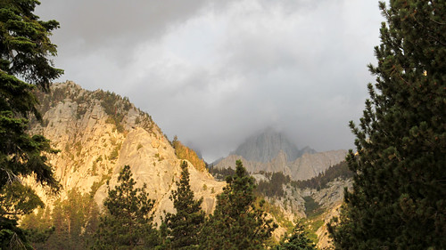
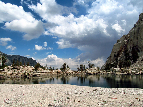
Our permit was for Tuesday, so we weren't too worried yet. The thunder was loud and the showers pretty persistent, but it led to some pretty cool visuals. Monday saw more of the same, although the showers were lighter, so we headed up to Lone Pine Lake for a couple hours.

Image

Image

Image


When we got back to camp, the weather seemed to be clearing a bit and we had hope that Tuesday would be clear enough to go for the summit. Sunday definitely would have been a bad day, and Monday was questionable...

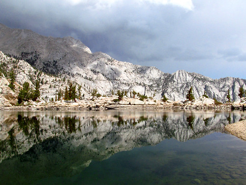
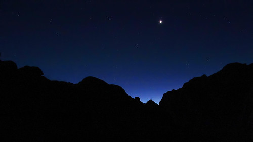
We hit the trail at 2:00am Tuesday, no moon and more stars than you can imagine. Not a cloud in the sky, so it looked good. Venus shone brightly above the eastern horizon and we reached Trail Camp just before sunrise:

Image

Image


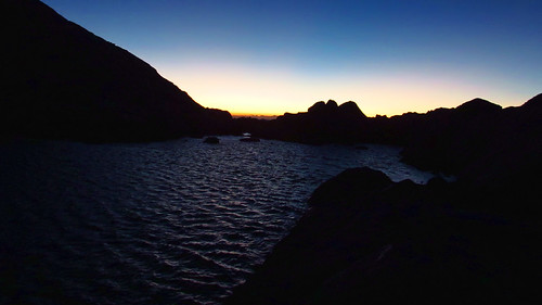
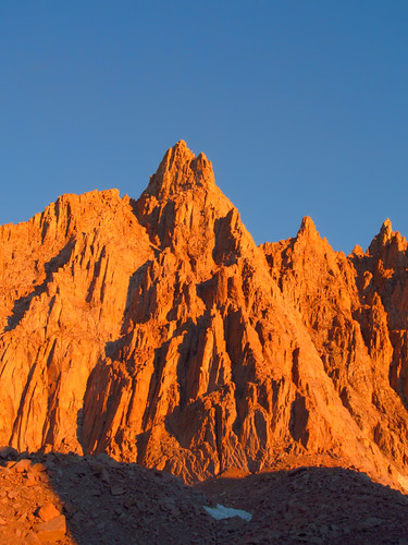
We stopped here to filter and took a break, waiting to catch the alpen glow on the crest before heading up the switchbacks. It's incredible to see how quickly the peaks seem to catch fire.

Image

Image


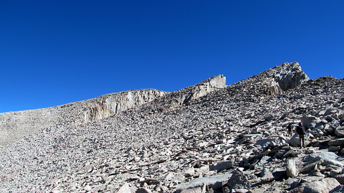
So up the switchbacks we went, encountering surprisingly few people. The regular dayhike crowd starts around 3 or 4, and the Trail Campers were just waking up when we were leaving, so we were ahead of the pack.

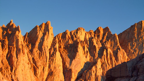
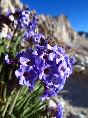
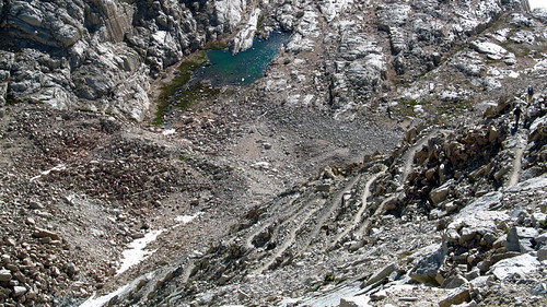
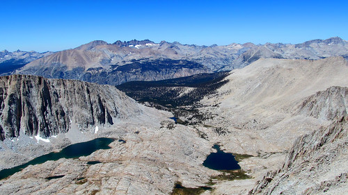
Fast-forwarding, here are a few shots from the switchbacks to the summit:

Image

Image

Image

Image


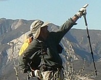
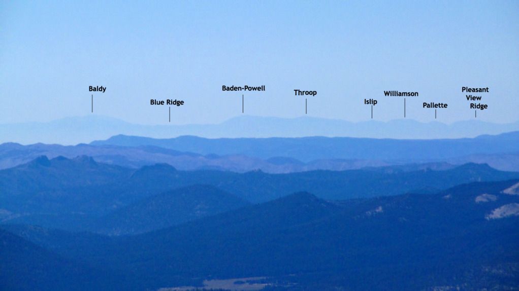
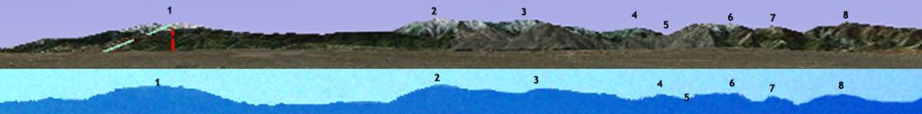
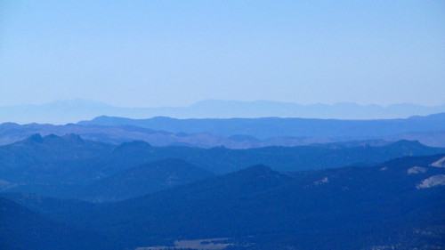
One of my favorite moments of the entire hike came at the top, looking at a seemingly insignificant series of bumps on the far southern horizon tucked in between countless others. The system that had dumped rain on us the past couple days cleared the air enough to where we could easily make out Baldy and the entire San Gabriel Range from 165+ miles away.

Image


See the rest of my 75 million photos here:

http://www.flickr.com/photos/wattifoto/ ... 763200606/

Cheers 8)
User avatar
bsmith
Posts: 119
Joined: Wed Oct 28, 2009 7:36 pm

Post by bsmith »

thanks for sharing!

i'm looking forward to my dayhike 8.22.12.
User avatar
Hikin_Jim
Posts: 4686
Joined: Thu Sep 27, 2007 9:04 pm

Post by Hikin_Jim »

mcphersonm80 wrote: we could easily make out Baldy and the entire San Gabriel Range from 165+ miles away.
OK, now that's cool.

HJ
User avatar
mcphersonm80
Posts: 243
Joined: Mon Aug 23, 2010 11:46 am

Post by mcphersonm80 »

Not 1,000,000% sure of this (is that Pleasant View?), but for kicks:

Image
User avatar
lesper4
Posts: 72
Joined: Tue Nov 23, 2010 9:38 am

Post by lesper4 »

I have no idea but I would think Baldy is actually Gorgonio and Baden-Powell is Baldy?
User avatar
Hikin_Jim
Posts: 4686
Joined: Thu Sep 27, 2007 9:04 pm

Post by Hikin_Jim »

Interesting question. Hard to say. Do you have any photos of the area to the immediate left and to the immediate right?

The gap marked as "Blue Ridge" looks way too wide to me...

Highly cool photo and question. I'm sure the brain trust here will dissect it in no time.

HJ
User avatar
JeffH
Posts: 1154
Joined: Sun Nov 28, 2010 7:09 am

Post by JeffH »

Great time out in the Sierras. Lone Pine Lake is highly underrated, mostly bypassed by everyone hustling to get up or down Whitney. I spent a few hours there one day when my permit was thunderstormed out. It's also a really good warmup/acclimation hike.
Yep, I'm getting ready too - permit for this year is August 31.

That's a really neat angle on the switchbacks, one I've never noticed. Hope I'll be coherent enough to look this year.


To the other comments:
If Baldy is Gorgonio and Baden-Powell is Baldy doesn't that mean Throop is Baden-Powell? And so on, and so on......

Still, it's awesome that you could see them and nearly as awesome that your camera could capture that much detail.
"Argue for your limitations and sure enough they're yours".
Donald Shimoda
User avatar
mcphersonm80
Posts: 243
Joined: Mon Aug 23, 2010 11:46 am

Post by mcphersonm80 »

lesper4 wrote: I have no idea but I would think Baldy is actually Gorgonio and Baden-Powell is Baldy?
Hikin_Jim wrote: The gap marked as "Blue Ridge" looks way too wide to me...

Those are exactly the thoughts I had at first, too. But a little bit of fooling around in Google Earth proved otherwise.

I started by drawing a line directly from Whitney to Baldy:

Image


I then zoomed in on that line to get keep the relative angle the same. Note how far off to the left of this capture San Gorgonio is:

Image


And finally I took the photo from the summit, jacked the contrast way up to highlight the contour line of the mountains, and resized to roughly match the Google Earth shot as close as I could:

Image

Some pixels were lost on either side of the line, but the contour is pretty spot-on.

Unfortunately I don't have any wider shots that are zoomed in enough to have captured the peaks, the camera metered on closer objects and essentially washed the far horizon out (our group shot at the summit in the flickr album is the right angle, for example. The SGs would but just above my left shoulder).

Another interesting note, doing the same straight line thing with Gorgonio, it appears the sight-line to Gorgonio is directly blocked by Olancha Peak.


This is fun. :lol:
User avatar
mcphersonm80
Posts: 243
Joined: Mon Aug 23, 2010 11:46 am

Post by mcphersonm80 »

bsmith wrote: thanks for sharing!

i'm looking forward to my dayhike 8.22.12.
JeffH wrote: Great time out in the Sierras. Lone Pine Lake is highly underrated, mostly bypassed by everyone hustling to get up or down Whitney. I spent a few hours there one day when my permit was thunderstormed out. It's also a really good warmup/acclimation hike.
Yep, I'm getting ready too - permit for this year is August 31.
Good luck, guys! I had concerns about the weather for obvious reasons, but as usual, it worked out. Couldn't have asked for better weather on our summit day, and hope you guys get the same.

I agree about Lone Pine Lake. In fact, the beauty of the entire trail often goes unmentioned, and instead people talk about their record times to the top, other hikers being underprepared, etc . Kind of strange, given that it's one of the most awe-inspiring trails I've set foot on.
User avatar
Phil B
Posts: 101
Joined: Wed Oct 03, 2007 12:47 pm

Post by Phil B »

Yup, looks like Google Earth proves the point, thats a pretty neat picture.

My Whitney date for this year is 21st Aug, but this year has special meaning as my thirteen year old hiking/ rock climbing grand daughter is coming over from Europe to hit the trail with me. Guess I will make this a 2am start as well to avoid those afternoon storms.

Cheers

Phil
User avatar
lesper4
Posts: 72
Joined: Tue Nov 23, 2010 9:38 am

Post by lesper4 »

So Google does have the answers for everything. Great pictures, I did Whitney last year as a through hike from Horseshow Meadows. I want to do it as a dayhike sometime. How is it compared to C2C?
User avatar
Hikin_Jim
Posts: 4686
Joined: Thu Sep 27, 2007 9:04 pm

Post by Hikin_Jim »

Ah! Nicely done. Didn't realize that you had already done so much homework. Very good.

HJ
User avatar
turtle
Posts: 152
Joined: Wed Jan 27, 2010 11:35 am

Post by turtle »

This is fantastic... thanks for walking us through the analysis.
User avatar
mcphersonm80
Posts: 243
Joined: Mon Aug 23, 2010 11:46 am

Post by mcphersonm80 »

lesper4 wrote: I want to do it as a dayhike sometime. How is it compared to C2C?
Can't say, as I haven't done C2C, but I'm surprised to find conflicting arguments on either side. I just assumed C2C would be tougher what with its 10,200+ feet of gain or whatever, but I suppose it comes down to how well you handle altitude...
User avatar
Phil B
Posts: 101
Joined: Wed Oct 03, 2007 12:47 pm

Post by Phil B »

Personally I find C2C a little harder than the Whitney day hike, this may be because of the extra preparation that I give to Sierra hikes which makes things go more smoothly. While they both require early starts 2am to 5am for most people, they are of course different animals, C2C has larger elevation gain and generally hotter temperatures, Whitney has the higher altitude and more fluctuating weather patterns.

Phil
User avatar
lesper4
Posts: 72
Joined: Tue Nov 23, 2010 9:38 am

Post by lesper4 »

I guess I will find out soon enough (I have done C2C before). We are planning on doing Langley in September and C2C in October. Langley should be about 400 ft lower with about 1500 less gain than Whitney.
User avatar
Apologist49
Posts: 1
Joined: Tue Aug 07, 2012 2:54 am

Post by Apologist49 »

mcphersonm80 wrote:
lesper4 wrote: I have no idea but I would think Baldy is actually Gorgonio and Baden-Powell is Baldy?
Hikin_Jim wrote: The gap marked as "Blue Ridge" looks way too wide to me...

Those are exactly the thoughts I had at first, too. But a little bit of fooling around in Google Earth proved otherwise.

I started by drawing a line directly from Whitney to Baldy:

Image


I then zoomed in on that line to get keep the relative angle the same. Note how far off to the left of this capture San Gorgonio is:

Image


And finally I took the photo from the summit, jacked the contrast way up to highlight the contour line of the mountains, and resized to roughly match the Google Earth shot as close as I could:

Image

Some pixels were lost on either side of the line, but the contour is pretty spot-on.

Unfortunately I don't have any wider shots that are zoomed in enough to have captured the peaks, the camera metered on closer objects and essentially washed the far horizon out (our group shot at the summit in the flickr album is the right angle, for example. The SGs would but just above my left shoulder).

Another interesting note, doing the same straight line thing with Gorgonio, it appears the sight-line to Gorgonio is directly blocked by Olancha Peak.


This is fun. :lol:
Actually, you CAN see San Gorgonio from Whitney, as the following page below shows - it's just to the left of Olancha Peak:

http://www.viewfinderpanoramas.org/gall ... itney.html

I also saw Baldy from Whitney in August 2010, though I was not 100% sure if I saw Gorgonio - after all 190 miles is very far, but I've seen the Sierra from San Gorgonio (Oct. 2009).

Line-of-sight research is always fun, for sure! :D
User avatar
Hikin_Jim
Posts: 4686
Joined: Thu Sep 27, 2007 9:04 pm

Post by Hikin_Jim »

Gorgonio from Whitney? Nice.

HJ
User avatar
calicokid
Posts: 90
Joined: Wed Feb 27, 2008 1:07 pm

Post by calicokid »

Phil B wrote: Personally I find C2C a little harder than the Whitney day hike, this may be because of the extra preparation that I give to Sierra hikes which makes things go more smoothly. While they both require early starts 2am to 5am for most people, they are of course different animals, C2C has larger elevation gain and generally hotter temperatures, Whitney has the higher altitude and more fluctuating weather patterns.

Phil
Just went to Whitey last Friday 8/10, we got thunderstorm, hail, and rain right at 1pm on the summit. It was a little bit hairy, but every one was fine. The noon-afternoon thunderstorm is consistent for the last 4 days we were there. An early summit time is advised.
Post Reply