SG's Grand Canyon - Waterfall - March 2011?

Trip planning, history, announcements, books, movies, opinions, etc.
Post Reply
User avatar
outwhere
Posts: 323
Joined: Sun Jan 25, 2009 5:40 pm

Post by outwhere »

1. March of this year? Does anybody know how much of the Grand Canyon was burned in the Station fire - thought I heard it was hit pretty hard.

2. I always wanted to get down in the bottom of that canyon but never did. Anyone here been down there? If so, anything memorable/nice scenery ?

tia...

http://www.summitpost.org/grand-canyon- ... ins/703279

Waterfall seen across Grand Canyon from the Mount Lowe Fire Road. San Gabriel Mountains, Ca. Mar.5, 2011.

Image
User avatar
cougarmagic
Posts: 1409
Joined: Wed May 07, 2008 5:21 pm

Post by cougarmagic »

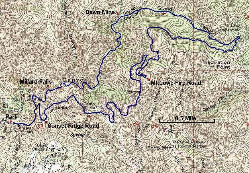
I have been down there before the fire. It's very nice, and easy to hike down Grand Canyon from the old tavern site. Finding the waterfall requires a GPS or good map skills, as it comes into Grand Canyon from a side canyon and you need to walk up into it to get a view of the falls.

I don't think it burned badly, if at all, right in that area. Mt Lowe camp (Tavern site) is supposedly untouched and the falls are very close.

http://www.dankat.com/advents/alpine.htm

(I should clarify - you do not need to canyoneer the falls to see it. You can hike to the bottom of it if you read Chris' description of the two different "exit" routes that are possible)
User avatar
Hikin_Jim
Posts: 4686
Joined: Thu Sep 27, 2007 9:04 pm

Post by Hikin_Jim »

CM,

Is that non-technical canyoneering to go down from the tavern site? I've been down a hundred meters or so from the tavern site but no further.

HJ
User avatar
MattCav
Posts: 356
Joined: Thu Sep 23, 2010 4:13 am

Post by MattCav »

you're right, cm... tavern site/campground is untouched from the fire, though just barely.
User avatar
outwhere
Posts: 323
Joined: Sun Jan 25, 2009 5:40 pm

Post by outwhere »

Thanks very much for that link Cougarmagic! That really helped me sort a few questions regarding the the canyon and the waterfall.

Good to hear that the Alpine Tavern area was spared in the fire.

Hope I'm wrong but one of the Station fire maps seems to show much of the Grand Canyon as part of the burned area.

[Hope pt.2] Maybe Matt will hit that area and snap a pic of a lush, green canyon :wink: :wink:...

It must have been an amazing sight to be on the north side of the Grand Canyon back in the day when you'd look across the canyon and see the Mt. Lowe trolly gracefully snaking along on it's way to the Alpine Tavern. Talk about 'grand' times!
User avatar
HikeUp
Posts: 3861
Joined: Thu Sep 27, 2007 9:21 pm

Post by HikeUp »

Here are some pictures I took in October 2009 of the area...sorta. Pics 27 thru 30 are a panorama of the Grand Cyn from high point 4714 (just above Inspiration Pt.). Other pictures include upper eaton cyn., easter rock (a few hundred feet from Inspiration Pt.), etc.
User avatar
cougarmagic
Posts: 1409
Joined: Wed May 07, 2008 5:21 pm

Post by cougarmagic »

Hikin_Jim wrote: CM,

Is that non-technical canyoneering to go down from the tavern site? I've been down a hundred meters or so from the tavern site but no further.

HJ
Yes - non technical. It is (or it was...) just a hike down a forested streambed.

(It would be advisable to have a rope and harness if you planned to go all the way down to Dawn Mine/Millard in the streambed. But I have never done that myself, so who knows...)

Oh what the heck - someone will do this if I post the link: :) http://www.dankat.com/advents/grandc.htm
User avatar
Hikin_Jim
Posts: 4686
Joined: Thu Sep 27, 2007 9:04 pm

Post by Hikin_Jim »

Is Millard Canyon open now?

Sounds very interesting. Some day. Once the bed bug crisis here is taken care of.

Image

HJ
User avatar
Paul Ayers
Posts: 42
Joined: Fri Sep 14, 2012 5:21 pm

Post by Paul Ayers »

As Chris B. notes the name of the falls is Chapman Falls. Named after the same Chapman who helped build the Plaza Church.
Post Reply