
What an amazing weekend it was, even though it was a bit to sunny for a February weekend. I am becoming a bit concerned that there might not be any more big storms this winter, which would be a real shame. My long weekend started on Friday, with a hike near Echo Mountain. During the week my wife and I had been driving around Alta Dena looking for a nicer place to live then our current abode. We were driving east bound on Loma Alta Dr when I spotted this very cool looking dry waterfall below the Echo Mountain Toll Road. On Friday I hiked up to do some further investigation. It was a steep hike up the ridge with a 1,200 foot elevation gain in 1.05 miles!
View from the high point.
When I reached my high point, I dropped into the canyon via the brush-choked hillside. It was an epic hike down where I was literally walking on top of bushes they were so thick.
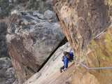
When I reached the canyon bottom I discovered a beautiful untouched “paradise”. Over time the water has carved amazing rock formations into this narrow canyon. There was no signs of human passage, no garbage, no spray paint just nature at its finest .The 1st waterfall came quickly and required a fun 5th class chimney to descend. The 2nd waterfall came shortly thereafter, a three-tiered drop of about 15 meters.
view looking up from the top of the bottom tier.
The water had carved a very narrow “crack” down the center that allowed a fun 4th class decent down all three tiers. The 3rd waterfall (all of them were dry, the canyon is only fed by storm runoff) had a short 5th class chimney to a sandy platform followed by a very steep 15-meter drop.
I was unable to rappel down this waterfall as there were no suitable anchors so I bypassed on the hillside and rapped from a large oak tree to the canyon bottom.
A short hike down the canyon revealed the gem, an amazing granite dry waterfall about 30 – 40 meters tall (best guess when looking down from the top and Google Earth). Unfortunately there were no suitable anchors (I was hoping for a nice tree) so I was unable to descend. I spent some time soaking in the views while emptying my boots and ascended my rope up the loose and cliffed out hillside and began the long and arduous ascent back out of the canyon.
Total trip time: 3hours
On Sunday I decided against watching the Super Bowl and instead drove out to Moreno Valley, where a buddy of mine lives. He had been talking a lot about the amazing climbing potential just out his backdoor and I decided we should check it out. He wasn’t lying we spent the afternoon climbing amazing boulders up to 10 meters tall putting up V2 to V4 First Ascents on impeccable rock. We even found a large rock that we Top Roped (about 20 meters tall). We put up two routes, one was mid 5.11 range and the other was a hard 5.10 or easy 5.11. The upper portion of the route was on high quality granite with very sharp (and very small) knife edged holds. It was surreal. We finished off the night with Mexican food at Cuca’s in Redlands (if you’ve never been you need to go). I got home late so I was up late packing for my next adventure on Monday.
Monday morning I awoke early and drove to Icehouse Canyon. I made it to the saddle in 75 minutes, which by the way is quite the hike.
Snow level was right at the Cucamonga Wilderness boundary.
From the saddle I hiked up Timber Mountain (8,303ft)...
...Then dropped back down to the saddle and summited Bighorn Peak and Ontario Peak! It was a great day! Crampons definitely would have made it safer and faster and not to mention having sunscreen would have made the post hike a bit more enjoyable!
Bighorn Summit (8,441ft) shot! Also if anyone is planning a trip there soon the summit register has less than one page left...
Ontario Peak (8,693ft) summit shot!
It was a long day with the majority spent hiking/climbing on snow and ice. In places I was post-holing almost to my waist in others the snow was powdery and soft and quite a few times the ice was so hard it was nearly impossible to kick steps.
Breaking in my new Kayland MXT boots, Love em!!!
On the decent I lost my footing more than once and had to employ my ice axe to arrest my plunge.
It was an 8.5 hour day, I know I could have done it faster with crampons because there were several sections where I was moving very carefully (aka slowly) as a slip would have proven very bad for my health.
I dropped down into Icehouse via this canyon, which had an impressive dry waterfall... Does anyone know the name of the canyon (sorry it isn't the greatest shot)?
It was beautiful day up there in an amazing alpine like setting (kind of reminded me of some of my High Sierra hikes). I did not see anyone the whole day. I even had a Snow White moment as I was hiking up to the saddle in the morning when I was being followed by a large troop of chipmunks and chickadees!
I do have 2 questions for the forum: 1) Why is it called Icehouse Canyon (besides being cold) & 2) Is there a register on Ontario Peak? I could not find it...
So besides a bad sunburn on my face and neck, a strained tendon in my forearm, a weird rash on my biceps (from some sort of plant) and a large gash on my face (got in a fight with a log on Friday) I am in great shape and cannot wait for next weekend!!!!
Adventure filled weekend!
-
simonov

- Posts: 1102
- Joined: Tue Nov 27, 2007 5:44 pm
- Location: Reno, NV
Wow, that's a lot of hiking and climbing on one day.
It's called Icehouse Canyon because it was the site, in the 19th century, of an ice factory/warehouse (back when refrigeration meant delivering ice that had been stored since the winter).
There is usually a register on Ontario Peak. As I recall, last time I was there, it was a plastic Folgers coffee container and it was crammed into some rocks under the dead tree.
Nunc est bibendum
-
lilbitmo

- Posts: 1092
- Joined: Tue Mar 04, 2008 9:44 pm
rokclimbr - Great TR, nice pictures, way to knock out three peaks in one day. Simonov is correct., the upper end of the canyon used to get more running water and major frozen chunks of ice were carted down to the parking lot area, carved up and delivered on trucks to the urban areas.
I've never seen the log register on Ontario but I've been told it's there, the canyon you downclimbed, is it the one closest to the saddle area by Bighorn just before you get to the main trail at Icehouse Saddle? Taco will know the name of that one.
Thanks for the TR
I've never seen the log register on Ontario but I've been told it's there, the canyon you downclimbed, is it the one closest to the saddle area by Bighorn just before you get to the main trail at Icehouse Saddle? Taco will know the name of that one.
Thanks for the TR
-
Taco

- Snownado survivor
- Posts: 6125
- Joined: Thu Sep 27, 2007 4:35 pm
If you can put a virtual pin in a virtual map for that canyon, I can probably tell you a bit about it.
Cool TR, thanks for posting! I especially dig that canyon.
Cool TR, thanks for posting! I especially dig that canyon.
-
rokclimbr

- Posts: 124
- Joined: Mon Jan 03, 2011 5:32 pm
Here is the screenshot of my GPS App that shows my route (the rest-stop waypoint was taken on the way to Ontario Peak) My route down started just west-southwest of the rest-stop.
Here is a Google Terrain which shows the topography a bit better.
I saw the beer opener nailed to the tree, on top of Ontario Peak, but no Folgers Coffee container. Maybe it was buried under snow...
I was kind of hoping I dropped down the right canyon so I could check out Phoenix Wings but I was to far east
-
Taco
- Snownado survivor
- Posts: 6125
- Joined: Thu Sep 27, 2007 4:35 pm
I believe that is Delker Canyon. Phoenix Wings is up in Falling Rock Canyon, just above the same elevation as Sugarloaf's summit.
-
turtle

- Posts: 152
- Joined: Wed Jan 27, 2010 11:35 am
I unfortunately cannot find the reference, but I once saw on the web a "Bushwacking Scale" reminiscent of the YDS.rokclimbr wrote: It was an epic hike down where I was literally walking on top of bushes they were so thick.
Departing the ground as you describe is what defined "Class 5" bushwacking.
-
rokclimbr
- Posts: 124
- Joined: Mon Jan 03, 2011 5:32 pm
It definitely felt "Class 5"! I am surprised I didn't get any ticks!
-
MattCav

- Posts: 356
- Joined: Thu Sep 23, 2010 4:13 am
awesome t.r.'s, rok! i feel lazy all of a sudden... truly inspirational stuff.
-
rokclimbr
- Posts: 124
- Joined: Mon Jan 03, 2011 5:32 pm
@MattCav - I was looking at Iron Mtn the other day, what a peak. you shouldn't feel lazy