

It is Official: Mt Baldy Road Closed
-
hvydrt
- Posts: 494
- Joined: Thu Sep 27, 2007 8:18 pm
I think the 38 and 18/330 are closed also. I wonder what part of Angeles Crest HWY was destroyed this time?
-
xmastree
- Posts: 3
- Joined: Sat Dec 18, 2010 5:57 am
I called the Baldy ski lifts yesterday and I was told that Manker Flats is flooded.
-
Ze Hiker

- Posts: 1432
- Joined: Mon Jul 28, 2008 7:14 pm
lol yeah once I was told Heaton Flat was flooded. of course that was after an insignificant amount of rain compared to this weather.
trust me if it was the rangers saying this (and not ski lifts) I still wouldn't trust them!
trust me if it was the rangers saying this (and not ski lifts) I still wouldn't trust them!

-
Hikin_Jim

- Posts: 4688
- Joined: Thu Sep 27, 2007 9:04 pm
I hear that the summit of Mt. Baldy is flooded.
HJ
HJ
-
norma r

- Posts: 707
- Joined: Thu Nov 06, 2008 4:22 pm
i'm not surprised by the amount of water and mud we saw flowing on Sunday. too many days of constant deluge. well there is always the Bear Flat Trail.
i'm heading out of town for the holiday and was totally bummed to know i was gonna' miss out on seeing what this storm left behind. hope you all get up there soon. have fun, be safe!
-
harryquach
- Posts: 4
- Joined: Thu Oct 21, 2010 10:23 pm
Am I missing something or did mt baldy move east of the 15. According to the TV map it has moved
-
AlanK

- Posts: 1069
- Joined: Thu Sep 27, 2007 9:28 pm
The flow got REALLY heavy!harryquach wrote: Am I missing something or did mt baldy move east of the 15. According to the TV map it has moved
-
mattmaxon

- Posts: 1137
- Joined: Mon Mar 24, 2008 12:48 pm
Prolly the same parts they just spent $$16.5 million fixinghvydrt wrote: I think... I wonder what part of Angeles Crest HWY was destroyed this time?
Should have put in the via-duct on the lower washout. Ladybug Cyn is a problem.
So expect the reopening gala sometime around 2014 or 2015
-
Johnny Bronson
- Posts: 179
- Joined: Mon May 31, 2010 2:04 pm
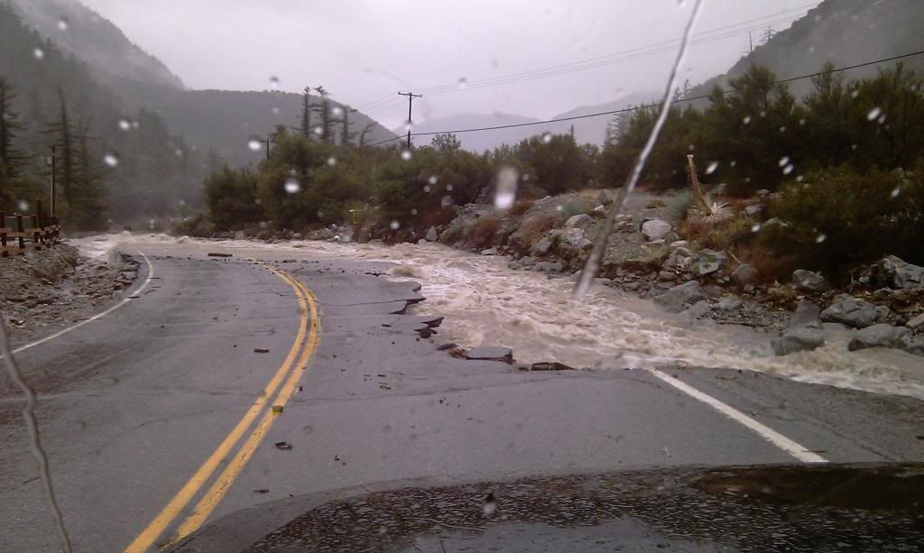
A buddy of mine who lives up there sent me this pic yesterday, part of the road collapsed stranding some residents(again)...
-
hvydrt
- Posts: 494
- Joined: Thu Sep 27, 2007 8:18 pm
Wow! That looks like the area between Ice House and the village?
-
norma r
- Posts: 707
- Joined: Thu Nov 06, 2008 4:22 pm
looks like we'll be doing some major snow climbs... Village to Baldy, IHC to Baldy, Iron to Baldy. where there's a Will there's a Way! our quads will be in good shape, that's for sure!
-
simonov

- Posts: 1100
- Joined: Tue Nov 27, 2007 5:44 pm
- Location: Reno, NV
Looks like some San Gorgonio snow climbing is in our future.
Nunc est bibendum
-
AW~

- Posts: 2088
- Joined: Mon Oct 01, 2007 12:00 pm
From what I read nothing was wrong, just the 'precautionaty' measure. I remember many people getting fear stuck last year....nevertheless, someone decided to forgo the closure and...mattmaxon wrote:Prolly the same parts they just spent $$16.5 million fixinghvydrt wrote: I think... I wonder what part of Angeles Crest HWY was destroyed this time?

Should have put in the via-duct on the lower washout. Ladybug Cyn is a problem.
So expect the reopening gala sometime around 2014 or 2015
12/21/2010 10:37 Missing Motorcyclist Search & Rescue Angeles Crest Highway/Newcomb's Ranch
-
EnFuego

- Posts: 677
- Joined: Mon Dec 15, 2008 11:14 am
"All travellers who had preceded me into the Barren Grounds had relied on the abundant game, and in consequence suffered dreadful hardships; in some cases even starved to death."simonov wrote: Looks like some San Gorgonio snow climbing is in our future.
San Gorgonio? Really?
-
simonov
- Posts: 1100
- Joined: Tue Nov 27, 2007 5:44 pm
- Location: Reno, NV
Latest news from a buddy in Wrightwood is that the rain which has been washing out roads up three has just turned to snow.
Nunc est bibendum
-
Taco

- Snownado survivor
- Posts: 6124
- Joined: Thu Sep 27, 2007 4:35 pm
-
snmtbaldy
- Posts: 66
- Joined: Tue Nov 24, 2009 7:01 pm
The Mt. Baldy road is clear till the bridge just 100 yards beyond the visitor center. It is closed for public higher up. It is ONLY open for residents.
As of at 7:28 12/23/2010.

This is the snow level.

According to the maintenance crew, it will take some time to repair the damage caused by the storm.
My friend took off to Bear Flat trail this morning.
Shin
As of at 7:28 12/23/2010.
This is the snow level.
According to the maintenance crew, it will take some time to repair the damage caused by the storm.
My friend took off to Bear Flat trail this morning.
Shin
-
Dave G

- Posts: 321
- Joined: Sun Jun 22, 2008 9:51 am
Just heard that the road is open all the way up. 
-
Funyan005
- Posts: 203
- Joined: Tue Apr 01, 2008 11:17 pm
Road is definately open all the way. The part that washed out is all dirt now. Pretty well packed in, just hopefully no more huge torrential rains

-
solar

- Posts: 14
- Joined: Fri Aug 21, 2009 9:08 pm
Was that on Sunday?
This morning, Monday 12/27 the Forest Service was turning people around at the fire station.
Took a hike up to Sunset Peak instead of IHC.
Looking down from the ridge, there was no traffic moving past the Trout Ponds.
Looked like Buckhorn lodge was jumping, tho'!
Upon returning to the car there was about 20 cars parked in the Mt Baldy Ranch RV Park turnout. The people were just standing around starring at the snow that was... so close, but oh so far!!!
Sunset Peak is pretty cool!
-
Johnny Bronson
- Posts: 179
- Joined: Mon May 31, 2010 2:04 pm
Just got back from the area with taco,the road is blocked off to residents only.
Though you can get in if you go really early in the am to avoid that as we did and were also advised by the nice gentleman working the roadblock.=D
When we were leaving at about 3:00 ,people were just walking up the road in hords lol jam packed traffic a good ways down.
Manker flats and up till the skilifts had a bunch of gravel trucks doing round about runs and road work.
A bit of wind,Snow/weather was very good.
-
simonov
- Posts: 1100
- Joined: Tue Nov 27, 2007 5:44 pm
- Location: Reno, NV
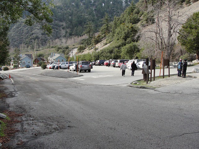
Since the repaired road is just gravel, I suspect they graciously opened the road on Sunday only to allow the Mt Baldy Ski Area, as well as the Snowcrest, etc, to take advantage of the big holiday storm. And maybe to allow hikers into Icehouse Canyon, since the parking lot quickly filled with cars, as can be seen here:
Maybe they closed the road again today so they can continue working on it and making the repairs more permanent in time for this next weekend.
Just guessing. It was definitely open yesterday.
Nunc est bibendum
-
asbufra
- Posts: 135
- Joined: Sun Oct 26, 2008 10:27 pm
http://www.mtbaldy.com/
This is from the Ski Area Web site:
"Temporary Road Closures:
The San Bernardino County Department of Public Works has done a phenomenal job of repairing and clearing the road to Mt Baldy ski area after our recent storm. Although we received over 25 inches of rain and nearly 3 feet of snow, the county crews were able to make the roads passable and safe for access to the ski area. The county will be doing maintenance and repair today (Monday) and tomorrow (Tuesday). They will delay the balance of the work until later to enable the skiing public to enjoy skiing during the holidays Although this huge storm brought torrential rains, it brought some of the most phenomenal snow for skiing in years..
If you are going to ski or snowboard tomorrow (Tuesday) you must be up to the ski area parking lot about 9:00 am to avoid road closures for uphill traffic. Please print out this webpage or your reservation and bring it up with you.
We should be open and accessible all day Wednesday-Sunday thanks to the county. Note during these days try to arrive at the ski area as early as possible to avoid any road block due to the heavy traffic that may come from snow play."