
On the other hand, if I could show you an newspaper article in which the only mistake was a single word, you'd give it a pass, right?Hikin_Jim wrote:Wow, there's a 66 mile long pass up there? Boy am I ever glad they printed this article to clear up any confusion.About 20 miles of the 66-mile mountain pass...
Angeles Crest Highway (CA-2)
-
AlanK

- Posts: 1069
- Joined: Thu Sep 27, 2007 9:28 pm
-
Ze Hiker

- Posts: 1432
- Joined: Mon Jul 28, 2008 7:14 pm
your radar just isn't very good."It wasn't even on my radar that this was closed," Groves said as he stopped to fill his water pouch near the intersection of Angeles Crest Highway and Angeles Forest Highway. "I had read that it was clear to come up from the Palmdale side so I figured everything here was cool."
gee I wonder why there are all these "closed" signs all over the place where there is no vegetation left? hmm I dunno let's continue hiking.Some of the trespassing seems to be due to genuine misunderstanding about the status of different portions of the road and forest. In late June, Caltrans Public Information Officer Patrick Chandler intercepted a dozen family members setting off on a hike.
"They parked at Angeles Forest Highway where it meets Angeles Crest and walked up to the closure and were going to go down Switzer Falls," Chandler said.
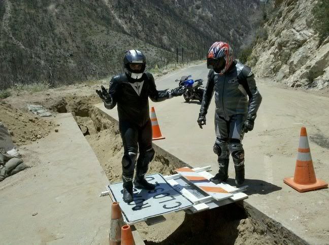
it's good the motorcyclists are keeping up their end of the crest death toll even though the road is closed. good looking outL.A. County Fire Battalion Chief Mitch Brookhyser confirmed one such incident. On May 31, units from La Cañada's Station #82 responded to a call of a motorcycle that had gone off the side of Angeles Crest, Brookhyser said. The responders were forced to stop at a locked gate. The call was canceled minutes later, he said.
damn cyclists. this guy is a moron. really you didn't know there was damage, with road closure signs and dump trucks? hell I admittedly cycle up 39, but wouldn't pretend I didn't know it was closed. idiot."Big Tujunga Canyon was open," Blake said. "Then they had some signs on Angeles Forest Highway that it was closed ahead, but cars could go through. At Angeles Crest Highway they had a gate, but I could get through there."
He enjoyed having the road to himself, Blake said, although he did have to steer clear of a couple of dump trucks.
"I thought it was great, there was no traffic," Blake said. "But I wasn't aware they had this kind of damage here. I wasn't prepared for this."
-
cougarmagic

- Posts: 1411
- Joined: Wed May 07, 2008 5:21 pm
What exactly was this guy's plan?? Hitchhike down?With a small day pack strapped to his back, Scott Groves set out from his home in Pasadena to the foot of Mt. Wilson Trail in Sierra Madre. He climbed seven miles to the top of the mountain and then proceeded down Mt. Wilson Road before happening upon the closed portion of Angeles Crest Highway (SR-2).
The former Boy Scout and U.S. Army soldier had already been hiking for five hours, and it was too far to turn back.
-
Hikin_Jim

- Posts: 4688
- Joined: Thu Sep 27, 2007 9:04 pm
I was up there yesterday afternoon (taking Joyce on her first "real" hike). The place is almost deserted. I thought that maybe the heat scared people off, but the guy at Newcomb's Ranch said that business was down about 70% because of the road closures. I guess people don't want to do that extra 30 or 40 minutes to go up Big T.Zé wrote:it's good the motorcyclists are keeping up their end of the crest death toll even though the road is closed.
The motorcyclists, however, were not in short supply at Newcomb's!
HJ
-
AW~

- Posts: 2119
- Joined: Mon Oct 01, 2007 12:00 pm
-
Taco

- Snownado survivor
- Posts: 6208
- Joined: Thu Sep 27, 2007 4:35 pm
That's friggin' great!
We're all the same.
We're all the same.
-
EManBevHills

- Posts: 387
- Joined: Fri Sep 28, 2007 12:40 am
I went for a bike ride up Big T yesterday. Got too late of a start after watching the Tour, and the heat was on. I saw a reading on my bike thermometer of 116 at one point, and it was consistently over 100.
But here's an update on the roads:
Lower Big T from Mt. Gleason to before the Angeles Forest sign was being repaved yesterday and there were regular construction delays of 5-10 minutes. The ANF heading towards the Angeles Crest (2) was also posted as closed for construction activity, although the gate was open presumably for trucks.
There is no roadside parking at all on Big T.
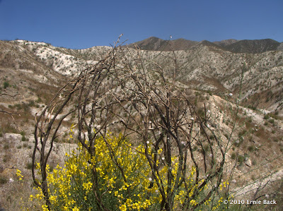
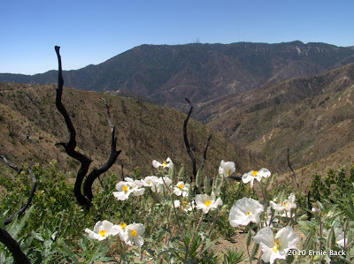
Upper Big T was in good shape, although the fire made the landscape pretty barren. There were loads of wildflowers, butterflies, and signs of new growth.
There were signs posted at most trailheads indicating they were closed.
But here's an update on the roads:
Lower Big T from Mt. Gleason to before the Angeles Forest sign was being repaved yesterday and there were regular construction delays of 5-10 minutes. The ANF heading towards the Angeles Crest (2) was also posted as closed for construction activity, although the gate was open presumably for trucks.
There is no roadside parking at all on Big T.
Upper Big T was in good shape, although the fire made the landscape pretty barren. There were loads of wildflowers, butterflies, and signs of new growth.
There were signs posted at most trailheads indicating they were closed.
-
simonov

- Posts: 1110
- Joined: Tue Nov 27, 2007 5:44 pm
- Location: Reno, NV
Can we drive there now? I'd like to schedule a hike to Mt Baden-Powell from there.
Nunc est bibendum
-
yobtaf

- Posts: 297
- Joined: Fri Jun 12, 2009 8:52 am
I was up there a couple weeks ago and they said the road was still open, coming from wrightwood. I also checked with the caltrans person I know, we are delivering concrete still up on hwy 2, and he said you can come in that way.
-
Hikin_Jim
- Posts: 4688
- Joined: Thu Sep 27, 2007 9:04 pm
It shouldn't be a problem. You can come in through either Wrightwood or Big Tujunga although from OC you'd probably want go through Wrightwood.simonov wrote:Can we drive there now? I'd like to schedule a hike to Mt Baden-Powell from there.
HJ
-
Phil B
- Posts: 101
- Joined: Wed Oct 03, 2007 12:47 pm
I climbed Baden-Powell on Saturday (10/09/10) and noticed that the gate at Vincent Gap was finally open to traffic. It seems ages since that was last open, is the Angles crest highway open all the way to La Canada? are the restrictions from last years fire lifted? can we now get back to hiking all the trails in the area? It would be great getting back to normal.
Cheers,
Phil
Cheers,
Phil
-
Taco
- Snownado survivor
- Posts: 6208
- Joined: Thu Sep 27, 2007 4:35 pm
I believe it's still closed to about Mt Wilson, requiring a redirect to AFH or Tujunga. Others should be able to fill you in on the real intel.
-
AlanK
- Posts: 1069
- Joined: Thu Sep 27, 2007 9:28 pm
I just happened to talk to someone today about driving to Mt. Wilson. You have to go up Lower Big Tujunga Canyon Road to Angeles Forest Highway. However, you can't take a right and go over to Rt. 2 at Clear Creek. Instead, you have to take Angeles Forest Highway towards Palmdale and turn onto Upper Big Tujunga Canyon Road to Rte. 2. You can then backtrack to Mt. Wilson. Or go left towards the higher peaks. From the 210 offramp to Mt. Wilson is 36 miles.
-
cougarmagic
- Posts: 1411
- Joined: Wed May 07, 2008 5:21 pm
Very nice history of the road, and explanation of the current repair work.
http://www.latimes.com/news/local/la-me ... ory?page=1
http://www.latimes.com/news/local/la-me ... ory?page=1
-
HikeUp

- Posts: 4082
- Joined: Thu Sep 27, 2007 9:21 pm
Thanks for the link! Good story.
And no mention of global warmening!
And no mention of global warmening!
-
Richard N.
- Posts: 91
- Joined: Tue Feb 12, 2008 9:47 pm
I have heard rumors that ACH pout of la Canada might be opened near the end of November. A couple of bridges are being built where the highway slipped away a few months ago. The rumors are from the USFS so we know what that might mean.
If I were a betting man, and I am, I'll say good luck to the end of November. Once the rains come the whole highway will be shut down due to concerns of mud and debris flows on the roadways.
If we get heavy rains, expect the roads to just wash away and end up in the Pacific. Maybe we'll get lucky and Jody will wash away into the Pacific as well.
Well, let hope she washes down the Santa Ana to the Pacific.
-
lik2hik

- Posts: 82
- Joined: Sun Sep 30, 2007 8:46 am
Here is a link to an LA Times article that explains how some of the major problem areas are being repaired.
http://www.latimes.com/news/local/la-me ... .htmlstory
http://www.latimes.com/news/local/la-me ... .htmlstory
-
simonov
- Posts: 1110
- Joined: Tue Nov 27, 2007 5:44 pm
- Location: Reno, NV
Haven't any of those people ever read any John McPhee?
Nunc est bibendum
-
AW~
- Posts: 2119
- Joined: Mon Oct 01, 2007 12:00 pm
How about CalTrans being the most hostile agency to mtn users in the USA? There are landslides all the time, and they are typically reopened quickly...in days/weeks rather than Caltrans years/decades.simonov wrote:Haven't any of those people ever read any John McPhee?
Lets go back in time to 1999. Remeber that year? That was the year, the 'project' began to repair a bridge along Hwy39.
http://www.dot.ca.gov/dist07/Publicatio ... .php?id=60
You'll see in the link all the 'adventure' and 'challenge' they think it takes to repair a small bridge....
"Last October(yr 2006), the Design team literally worked around the clock for seven days on the bridge just to find the proper equipment that would not damage the bridge, but strong enough to lift and hoist the drilling equipment over the rails and down to the riverbed for the drilling operation. "...or 168 hours straight to know what equipment to use.
Compare that to http://dma.mt.gov/des/Library/2007_PDM_ ... dslide.pdf
The Montana/Beartooth/Yellowstone slide of 2005, which 12 miles of highway long was repaired in less than 6 months at a cost of $15.2million...compared to $16 million thus far for just the ACH. It also mentions Montana Highway 287 from the 1959 earthquake which was "buried to depths as great as 394 feet" and opened less than a year later.
-
hvydrt
- Posts: 494
- Joined: Thu Sep 27, 2007 8:18 pm
That's not really very long considering what they were doing. Its not like you can go to home depot and rent a crane. The equipment came from Sacramento. It takes time to move machines like that around.AW wrote:The Design team literally worked around the clock for seven days on the bridge just to find the proper equipment that would not damage the bridge, but strong enough to lift and hoist the drilling equipment over the rails and down to the riverbed for the drilling operation........
-
norma r

- Posts: 707
- Joined: Thu Nov 06, 2008 4:22 pm
cool graphics. thanks for sharing the link CM and lik2hik.
-
EManBevHills
- Posts: 387
- Joined: Fri Sep 28, 2007 12:40 am
Interesting graphics. Appreciate the links, as well. Danke.
-
simonov
- Posts: 1110
- Joined: Tue Nov 27, 2007 5:44 pm
- Location: Reno, NV
Well, my John McPhee reference was about how difficult it is to build a highway through the San Gabriels, one of the most unstable mountain ranges around.
Compared to the rest of the country, CalTrans actually delivers timely projects and good value for money. We have highway projects here in California completed in a couple years that would literally take decades in corrupt east coast states.
Nunc est bibendum
-
yobtaf
- Posts: 297
- Joined: Fri Jun 12, 2009 8:52 am
wow a year later...
I personally drove a load up to hwy 2, 4 miles past the split for palmdale and they have a long way to go. It was my first time going up there, I usually just load the trucks. The new crew that is doing most of the work is doing a great job on ordering and not wasting money, and seem to have their hands full with all the work up there. I drove through 2 spots where the road is gone and where I delivered is the 3rd spot they are working on. Pretty sad to see all the destruction and no animals at all. I will try and take a camera up there next time.
I personally drove a load up to hwy 2, 4 miles past the split for palmdale and they have a long way to go.
-
lik2hik
- Posts: 82
- Joined: Sun Sep 30, 2007 8:46 am
Looks like they expect to open it up this month - unless the rains have something to say about it!
http://www.whittierdailynews.com/news/ci_16842265
http://www.whittierdailynews.com/news/ci_16842265
-
yobtaf
- Posts: 297
- Joined: Fri Jun 12, 2009 8:52 am
we have delivered about the last of the concrete that they need. I drove up 2 times this week and the road is good.