Mineral King, Sequoia, Big Kaweah

Archived TRs for Sierra Nevada ranges.
Post Reply
User avatar
lilbitmo
Posts: 1092
Joined: Tue Mar 04, 2008 9:44 pm

Post by lilbitmo »

A few days overdue but coming at you just the same :D

Zach and I headed to Sequoia National Park at Mineral King after he got out of class last Thursday, the plan was to go as deep into the park as we could on the first day (Friday morning), then continue to Big Kaweah and /or the Kern Hot Springs, he did the first, we never made the springs. On the way up we stopped just shy of Mineral King spending the night at Atwell Mill Campground a few short miles from the ranger station. Up early and grab our permit ($15 for walk ins - we both assumed it would be free but that changes on the 26th of Sept).

After clearing the car of any bear material we parked at the Monarch Creek Trail head and headed up the Sawtooth Pass/Timber Gap combo trail, then turned up the Sawtooth Ps Trail and made our way to the pass. If you've never carried a 40+ lbs pack straight up 1,200 feet in soft sandy conditions on a sunny day I highly recommend it, it will test your resolve and help you loose weight. :shock:

After making it over the top we continued down the Lost Canyon Trail to the junction with the Five Lakes Trail where we made camp for the night.
Early the next morning we headed south first to Big Five Lakes, then continued over to Little Five Lakes stashed some of our gear in the Bear Box there and continued down to the Big Arroyo where it almost touches the High Sierra Trail. After a 45 minute break to eat and set up some of our camp there we raced (I mean that) up the HST for 4.2 miles with a day pack to where the trees start to thin out and meet the scree fields that lead up to Big Kaweah - Zach looked at me and could tell I was nearing the end, sensing that it was decision time I encouraged him to go bag the big kahuna and I would meet him back at camp. I was only holding up the show and sometimes you just gotta say "Screw it" just didn't have it in me and I'm not one to keep anyone from doing what they want.

I headed back down to the camp area, collected wood (not easy to do) to make a fire, soaked my feet in the Big Arroyo creek, made dinner, laid down for 30 minutes and as soon as it got dark I started the fire. Less than two minutes later Zach rolled in from bagging Big Kaweah, we kicked it for 2 hours then called it a night.

Sunday morning we were up by 6:45, made breakfast, pack up and head out. This is where the real fun began, we made it back to Little Five Lakes, ate some more food then headed over the Black Rock Pass, dropped down the Pinto Lake (Zach decided to take a swim) then we kept going to where the trail meets Cliff Creek/Timber Gap Creek fork, by now we had covered 11.8 miles and it was fairly hot day, we had dropped over 4,000 feet from the last pass and it was time to regain 2,400+ feet in the next 3.5 miles. After eating some more snacks I took off like a bat out hell, halfway to the pass I was sucking wind, overheating and wasn't doing so hot. By the time I reached the pass I was "gagging on my water intake" I just could consume anymore it was making me ill, so I had to break for a while, then we covered the last two miles downhill to the car, soaked our feet in the Monarch Creek and headed home.

The skies were clear all four days, only ran into five peple the whole time, that area is stunningly beautiful, couldn't (editted section)ask for a better place to get away, had a great time in spite of feeling the effects of going uphill on the last climb to fast. :D

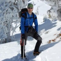
Zach's Pictures Here
User avatar
Elwood
Posts: 612
Joined: Fri Aug 15, 2008 5:23 pm

Post by Elwood »

Great report ! Zach's got a ton of beautiful pictures in there too.
User avatar
TracieB
Posts: 216
Joined: Mon Feb 22, 2010 8:57 am

Post by TracieB »

Nice photos - I'm glad it worked out for you guys, and that Zach was able to reach his goal. It's a lot different going the distance with a backpack than a daypack - but a great way to lose weight! I saw a bear out there but he didn't stop long enough to pose for a picture.
User avatar
PackerGreg
Posts: 623
Joined: Sat Sep 12, 2009 9:31 pm

Post by PackerGreg »

Let me know next time, while you were eating "snacks" I had the BBQ going on the deck of my Three Rivers home on the South Fork of the Kaweah River - same goes for the rest of y'all.
User avatar
Dave G
Posts: 321
Joined: Sun Jun 22, 2008 9:51 am

Post by Dave G »

Nice trip, you guys! That sure is beautiful country. I sympathize with you Patrick about the big pack. I hauled an overnight pack, including 6 liters of water, to the top of Whitney last week so that we could sleep on the summit, and my mantra during the climb up the switchbacks was "never again!". Hey, maybe if we pool our resources, we can get a timeshare deal on a Sherpa. :lol:
User avatar
Hikin_Jim
Posts: 4686
Joined: Thu Sep 27, 2007 9:04 pm

Post by Hikin_Jim »

What a fabulous area that is. I did a 5 day loop out of Mineral King (out Timber Gap, return Sawtooth Pass) last year. It was ab fab.

Out of curiosity, why did you guys go up Sawtooth and down Black Rock instead of the other way around?

HJ
User avatar
lilbitmo
Posts: 1092
Joined: Tue Mar 04, 2008 9:44 pm

Post by lilbitmo »

Hikin_Jim wrote:What a fabulous area that is. I did a 5 day loop out of Mineral King (out Timber Gap, return Sawtooth Pass) last year. It was ab fab.

Out of curiosity, why did you guys go up Sawtooth and down Black Rock instead of the other way around?

HJ
We were thinking of bagging Big Kaweah from the junction of the HST and easiest shortcut across the Big Arroyo up the steep side (east side) of the canyon wall, but from our vantage point we could not see the easy way up, so we went out of our way to go past the Big Five, then the little Five Lakes, then cutting back uphill on the HST in the southeastern directioin.

If I were doing this as a day hike or even went back to do this again, I wouldn't even hesitate to go due east, with a slight north inclination, there are at least two spots where you can go from the end of Lost Canyon across the Arroyo Meadow and up the other side (yes it's steep but there's at least two good places that I have spotted where the contour isn't bad to cut uphill between trees and isn't all scree) it will take you on a more direct route to the summit of Big Kaweah.

The far canyon wall can be intimidating but it's not that different from Register Ridge or Yaciapa Ridge or any other short cut route some of us do now. With full packs it would be a nightmare but with day packs it would be just another slug up tougher stuff. To me it's shorter to go this way by far, maybe 5 to 8 miles.

But looking back at the weekend we had out there I'm glad we went the way we did, it taught me how tough it can get in sandy conditions, that approach to Sawtooth with full pack is one of the hardest I've ever had to do, it's not to be taken lightly, I made that mistake and halfway up I was having my doubts, but I'm stubborn to the point of being silly sometimes, I made it but I was feeling it for the next three hours. :shock:

I would go back to that area in a heart beat. Timer Gap is very pretty as well and it made for a good way out and different views to the Loop we did, but I'm always in favor of going straight to where I want to be and going out on a multiple of choices - in this case there was only one choice other than the way we can in. :D
User avatar
Hikin_Jim
Posts: 4686
Joined: Thu Sep 27, 2007 9:04 pm

Post by Hikin_Jim »

I think the old trail to the Monarch Lakes area to Glacier Pass (use trail only) to Spring Lake, then along the 10K contour line to Black Rock Pass down through Little 5 Lakes to Big Arroyo and then to the drainage shown is considered the quickest way in from Mineral King. I'm basing that on Secor's book and on internet posting of others. I've seen the old trail at both ends. I don't know what kind of shape it's in, but it sure is a lot more direct route down than the current trail from Monarch Lakes which takes for-freaking-ever. You still have to pretty much ascend 90% of the way to Sawtooth to get to Glacier Pass which is pretty suck. Neat, neat area.

HJ
User avatar
Zach
Posts: 522
Joined: Sun Jan 04, 2009 4:25 pm

Post by Zach »

Looking back I wish we had at least TRIED to go all the way down and out of Lost Canyon. Patrick's right, there's gotta be a direct route up those cliffs... even if its class 3 it would SIGNIFICANTLY reduce the distance and time it would take you otherwise.
User avatar
mve
Posts: 414
Joined: Fri Dec 11, 2009 12:53 pm

Post by mve »

What a cool trek! And you can actually make fire!
User avatar
PackerGreg
Posts: 623
Joined: Sat Sep 12, 2009 9:31 pm

Post by PackerGreg »

Snow in the southern Sierras this morning - Alta Peak, Sawtooth. Not enough to stick to Castle Rocks. It's half melted now, but more weather on the way.
Post Reply