Baldy -North Backbone Trail-

TRs for the San Gabriel Mountains.
Post Reply
User avatar
mattmaxon
Posts: 1137
Joined: Mon Mar 24, 2008 12:48 pm

Post by mattmaxon »

Baldy -North Backbone Trail- @ Everytrail.com

We got to the trailhead on Blue Ridge road at the appointed hour of 6:30am and got going shortly after. I for one was not surprised to see other vehicles here but my fellow hikers Bernd and Johanna where somewhat surprised.

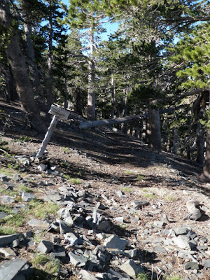
Though there is a trail on the map it is not a maintained trail. To look at it you'd say this is going to be a short trip, but there is a reasonable path The consensus was class 1.5 not quite a trail not really cross country scrambling etc...

Pine Mtn lived up to it's name with plenty of Lodgepole Pines, on the ridge below Pine Mtn the trail snakes through a large patch of Ceanothus cordulatus AKA Mountain White Thorn,or Snow Bush

We where hoping to see some Bighorn Sheep but alas it was not to be.

On Pine Mtn we made some navigational errors and failed in our Non-summit attempt of the NHPS listed Pine Mtn. Scandal and accusations ensued when examination the summit register as "HikeUp!" was at the head of the list.

Below Pine Mtn We passed the old Dawson Peak trail shown on most maps but it doesn't see much if any use. But looks to be in excellent shape.

Image

As we got to Dawson Peak Johanna said she wasn't going to Mt Baldy, the main purpose of this outing was a conditioning hike for a backpack trip later in the summer. I asked if she would possibly pick Bernd and I at Manker Flat. She agreed and we set a meet up time of 1:30pm

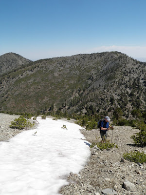
From Dawson Peak area Badly looks vertical but it is not, yes it is steep but "Zen and the art of uphill" is practiced here frequently I'm sure. About halfway up from the saddle (9450ft) there was a large patch of snow! Wow snow in SoCal in late July!

Image

We crossed over the summit of Baldy where Shin Nimura was completing his 200th Baldy summit.

We stopped below the summit for lunch in the shade, on the way down we must have passed 150-200 other hikers (or so it seemed) 1/2 of who made some comment on my Golite "Chrome Dome" Umbrella

By the time we got to Baldy Bowl and Harwood Lodge it was in the mid to upper eighties. Further down the trail some guy was humping up a 100lb backpack, he looked absolutely miserable, ever lower some girl noob was suffering from heat exhaustion sitting in the shade and vomiting.

I was filled with envy of the canyoneers enjoying the water at San Antonio Falls. A perfect day for it! We arrived at Manker Flat a bit late at 1:50pm. Johanna said she'd been waiting about 20 min.

I had a bit of a heat / dehydration headache and was / am a bit sore but I haven't done enough hiking lately. This is a hike I've wanted to do for years

THANK YOU Johanna!
User avatar
cougarmagic
Posts: 1409
Joined: Wed May 07, 2008 5:21 pm

Post by cougarmagic »

It was a nice day, and an interesting trail. It was steeper, and more un-maintained than I expected - but that's not a criticism!

This is what happens when you hike with canyoneers. Note Baldy in the background, yet these two guys are looking in the opposite direction - down into Fish Fork...:)

Image

Pine Mountain is a real deceitful place. We got OFF the trail and tried to wander aimlessly past the peak, and ended up right on top of it. My initial concern has faded, and I think we should give HikeUp a pass, and offer support if he needs it.

Image

Image

Image

I took one look at the slope heading up Baldy and wanted to take a nap. I think I ended up with the tougher hike back though - they only had to tackle that last bit, and then go downhill to Manker. But I had to go up Pine mtn again, and then a few steep bits up & down back to the car. So I got exercise after all.

I also thought the sound of the little slate-like bits of rock making up a lot of thr trail was cool. Like walking on dinner plates or something.
User avatar
HikeUp
Posts: 3902
Joined: Thu Sep 27, 2007 9:21 pm

Post by HikeUp »

Cool TR guys. I'm envious of Matt and Bernd for making the trip all the way to Manker, but I agree with Johanna that the hike back to Blue Ridge is not a cake walk either!

BTW, I make no apologies for bagging peaks. After all there is no shame in peak bagging!!! :twisted:
User avatar
Hikin_Jim
Posts: 4686
Joined: Thu Sep 27, 2007 9:04 pm

Post by Hikin_Jim »

Way to hang tough for NHPS on Baldy, Johanna. :)

Dunno who got the worst of it on that deal. That slidey N Face of Baldy is steep. The first time I looked at the Dawson-Baldy Saddle and realized just how much elevation I'd have to give up before climbing to Baldy, my jaw practically dropped. Interesting country though.

Matt, that trail down to Fish Fork may look good at the top, but I read a recent TR that said it's extremely difficult to follow. I also talked to a couple of guys last time I was down at Little Fish Fork that said the same thing.

It's with good reason that one would look longingly down Fish Fork. The middle section above the falls down by the East Fork but below the falls near Upper Fish Fork may go years in between human visits. I have never heard of anyone passing through there. Pretty inaccessible country.

HJ
User avatar
EManBevHills
Posts: 387
Joined: Fri Sep 28, 2007 12:40 am

Post by EManBevHills »

It's a real nice way to ascend Baldy. I always come away with an entirely different perspective on the range.
I don't get to go this way often enough, unfortunately. Logistics frequently become a major element of the equation.
User avatar
Ze Hiker
Posts: 1432
Joined: Mon Jul 28, 2008 7:14 pm

Post by Ze Hiker »

Hikin_Jim wrote: Matt, that trail down to Fish Fork may look good at the top, but I read a recent TR that said it's extremely difficult to follow. I also talked to a couple of guys last time I was down at Little Fish Fork that said the same thing.

It's with good reason that one would look longingly down Fish Fork. The middle section above the falls down by the East Fork but below the falls near Upper Fish Fork may go years in between human visits. I have never heard of anyone passing through there. Pretty inaccessible country.

HJ
geez can you make it any more tempting?
User avatar
Hikin_Jim
Posts: 4686
Joined: Thu Sep 27, 2007 9:04 pm

Post by Hikin_Jim »

wrote:
Hikin_Jim wrote: Matt, that trail down to Fish Fork may look good at the top, but I read a recent TR that said it's extremely difficult to follow. I also talked to a couple of guys last time I was down at Little Fish Fork that said the same thing.

It's with good reason that one would look longingly down Fish Fork. The middle section above the falls down by the East Fork but below the falls near Upper Fish Fork may go years in between human visits. I have never heard of anyone passing through there. Pretty inaccessible country.

HJ
geez can you make it any more tempting?
And I hear it's dangerous. Really dangerous. It'll be brushy, arduous, and hazardous. No one but a fool or a mad man would go through there.

:lol:

HJ
User avatar
mattmaxon
Posts: 1137
Joined: Mon Mar 24, 2008 12:48 pm

Post by mattmaxon »

Hikin_Jim wrote:Way to hang tough for NHPS on Baldy, Johanna. :)
The shame and humiliation of being busted on Mt San Gorgonio must have flashed back when we failed in our Nonsummit bid for Pine Mtn!
Dunno who got the worst of it on that deal. That slidey N Face of Baldy is steep. The first time I looked at the Dawson-Baldy Saddle and realized just how much elevation I'd have to give up before climbing to Baldy, my jaw practically dropped. Interesting country though.
The north backbone trail has nearly identical elevation gain and distance to Stone Cyn Trail to Mt Lukens, a mere walk in the park!
Matt, that trail down to Fish Fork may look good at the top, but I read a recent TR that said it's extremely difficult to follow. I also talked to a couple of guys last time I was down at Little Fish Fork that said the same thing.
Sounds like I'll have to check it out!
It's with good reason that one would look longingly down Fish Fork. The middle section above the falls down by the East Fork but below the falls near Upper Fish Fork may go years in between human visits. I have never heard of anyone passing through there. Pretty inaccessible country.
I know of one person though very few if any details are available, this is third hand information from recollections no written TR photos or other data
User avatar
Hikin_Jim
Posts: 4686
Joined: Thu Sep 27, 2007 9:04 pm

Post by Hikin_Jim »

mattmaxon wrote:The north backbone trail has nearly identical elevation gain and distance to Stone Cyn Trail to Mt Lukens, a mere walk in the park!
Starting from what point? Dawson-Baldy saddle?
mattmaxon wrote:
hikin_jim wrote:It's with good reason that one would look longingly down Fish Fork. The middle section above the falls down by the East Fork but below the falls near Upper Fish Fork may go years in between human visits. I have never heard of anyone passing through there. Pretty inaccessible country.
I know of one person though very few if any details are available, this is third hand information from recollections no written TR photos or other data
Ah, Fish Fork, great unknown of the San Gabriels!

HJ
User avatar
mattmaxon
Posts: 1137
Joined: Mon Mar 24, 2008 12:48 pm

Post by mattmaxon »

http://www.epicfail.com/
Epic Fail and Fail Pictures, Fail Videos, and User Submitted Anonymous Fail Stories

The Epic Fail website inspired this edited photo of our failed non-summit of Pine Mtn

After this failure I felt a rating system for non-summit bids.

Something like YDS or the ACA rating system

This will take considerable research, for a NHPS rating system.

Though I do like Johanna's suggestion for the NHPS 12 step program, literally 12 steps! That way you'll never risk summiting a peak ever again!

This is pure genius! It is so simple, and elegant KISS lives!

Image
Post Reply