
Iron>Baldy SA Ridge Traverse 6-11-10
-
Dave G

- Posts: 321
- Joined: Sun Jun 22, 2008 9:51 am
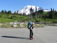
It was drizzle and fog as I swam/made my way for a little over 5 hours through the rainforest which is the Iron Mtn trail. I was completely soaked by the time I got to Allison Saddle and questioning the logic of hauling 5 additional liters of water in my pack when I was literally dripping with the stuff. Finally got some sunshine at about 7500’ and the weather was pleasant on Iron’s summit, so I spread most of my clothes out on the rocks to dry for an hour while I read the registers and otherwise enjoyed the day. Leaving Iron and heading east, I spent the next 6.5 hours very carefully (being solo and all) picking my way along the San Antonio Ridge and negotiating the various notches until I was past Gunsight Notch—where the technical difficulties end and the beloved Buckthorn begins—all the way to Baldy. Having done part of the ridge earlier this year with Zach helped a lot, but a lot of time is spent route finding on this hike—both through the notches and the Buckthorn. After tagging Baldy, I headed down the Baldy Bowl trail to the Ski Hut and on to Manker Flats, for a 10,545’ day. I still needed to get back to my Jeep though, and since I couldn’t get cell service anywhere, I hitchhiked a ride to the village with a carload of teenagers with a really loud sound system who drove way too fast (definitely the crux of the trip) and apparently through some misunderstanding, thought I was going to score some beer for them (I didn’t). Called my wife for a ride and eventually got home. Pics are here:http://www.flickr.com/photos/21042415@N ... 269605892/

-
AlanK

- Posts: 1069
- Joined: Thu Sep 27, 2007 9:28 pm
Eric mentioned seeing your entry in the summit log. While waiting for us to show up on Saturday, he had a lot of time to study it -- the only reading matter form miles around. Great trip -- and we're glad you survived, referring mainly to the trip down to the Village in that loud car. It was good judgment to let them brew their own beer.
-
lik2hik

- Posts: 82
- Joined: Sun Sep 30, 2007 8:46 am
Way to go Dave!
I know you've been working on it for a while waiting for the right time/conditions, and you got er' done.
Great pictures of the "route" along the ridge.
Congrats!!
I know you've been working on it for a while waiting for the right time/conditions, and you got er' done.
Great pictures of the "route" along the ridge.
Congrats!!
-
spotfin
- Posts: 53
- Joined: Fri Jan 01, 2010 2:30 pm
Nice Pics! This hike is on my "to do" list, looks like route finding will be a challenge, maybe first time out I'll only go half way and do a bit of exploring.
-
norma r

- Posts: 707
- Joined: Thu Nov 06, 2008 4:22 pm
Rock 'n Roll G-man! You did it, you really did! Congrats my friend! I know that traverse has been teasing you for quite some time and it's finally yours 
I bet that light rain kept the trail up Iron in great condition. Then taking the break to dry your clothes probably upped your endurance to navigate the ridge so efficiently.
Way happy for YOU! And great pix too.
I bet that light rain kept the trail up Iron in great condition. Then taking the break to dry your clothes probably upped your endurance to navigate the ridge so efficiently.
Way happy for YOU!


-
Phil B
- Posts: 101
- Joined: Wed Oct 03, 2007 12:47 pm
Great pictures Dave, you really caught the spirit of the ridge, and just when you think the worst is behind you the Buckthorn is there to welcome you up Baldy. Still at least you got lucky with a ride out, I quess after being picked up by your wife you had to go get your vehicle from the East Fork, that makes for a long day.
Cheers, Phil
Cheers, Phil
-
hamik

- Posts: 77
- Joined: Fri Jan 22, 2010 2:50 pm
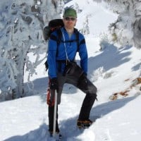
Nice! I remember you telling me you wanted to do this route. I like the picture of the class three part with the marine layer below.
-
tinaballina
- Posts: 182
- Joined: Thu Jun 18, 2009 11:28 am
Dave GGGGGGGGGGGGGGGGGGGGGGGGGGGGGGGGGGGGGGGGGGGGGGGGG
Congrats my friend. what is the mileage doing the traverse?
Congrats my friend. what is the mileage doing the traverse?
-
lilbitmo

- Posts: 1092
- Joined: Tue Mar 04, 2008 9:44 pm
Glad you are now able to put this one to rest - great pictures.
Good weekend to get this one done
Good weekend to get this one done
-
Sam Page

- Posts: 267
- Joined: Fri Sep 04, 2009 10:59 am
Great outing, Dave. Your summit self-portrait says a lot.
-
Dave G
- Posts: 321
- Joined: Sun Jun 22, 2008 9:51 am
Thanks everyone for the kind words! A few of you know how stoked I am to have this one sewn up--it has eluded me for a while. 
Tina~The entire hike (Heaton to Manker) was 16.4 miles. From Iron to Baldy is 3.9 (feels a helluva lot further ) as the crow flies. I'd have to look at my GPS track to give you my exact mileage for the traverse section.
Tina~The entire hike (Heaton to Manker) was 16.4 miles. From Iron to Baldy is 3.9 (feels a helluva lot further
-
Elwood

- Posts: 622
- Joined: Fri Aug 15, 2008 5:23 pm
Very, very nicely done and documented. I've gotta try this route someday. Still worried that Gunsight will wig me out.
-
TracieB

- Posts: 216
- Joined: Mon Feb 22, 2010 8:57 am
NICE! or should I say "epic" 
Great photos...
Great photos...
-
taktical
- Posts: 33
- Joined: Mon Feb 02, 2009 4:04 pm
Great work! Nice bumping into you at the visitor center on Friday night.
-
mve
- Posts: 414
- Joined: Fri Dec 11, 2009 12:53 pm
Congratulations Dave -- amazing route especially solo!