
The trailhead is 5.4 miles past the entrance gate to the Lake Piru Recreational Area. During winter months there is a locked gate at 1.2 miles from the entrance gate. And at 2.3 miles from the entrance gate there's another locked gate - always locked - just past the 2nd boat launch ramp. Two miles past the second locked gate is the Pothole Trail trailhead.
The Pothole Trail is 4.7 miles long. From the trailhead it gains 2,000', enters the Sespe Wilderness, and then loses about 1,000' to the Pothole. The Pothole was created when a mountainside slid - while no one was looking - a long time ago. And after heavy rains it fills with water. The trail can be hiked by itself or it can be the beginning - or end - of a Pothole Trail / Agua Blanca Trail loop.
On Saturday February 20, 2010 I joined a group of nine volunteers to do some trail work on the Pothole Trail. The group was led by Alan Coles of the Sierra Club in conjunction with the National Forest Service.
We left the trailhead at 09:43, reaching the junction where the trail heads down towards the Pothole at 12:25.

After a lunch break we headed down towards the Pothole,

turning around about 45 minutes later - about halfway to the bottom - due to time constraints.

During the outing we cut swaths through the grass reopening the path,

removed vegetation growing into and on the trail, and during the 45 minute downhill, bushwhacked our way through some very dense brush that has grown back since the 'Ranch' fire in 2007.

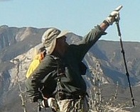
The weather was perfect and the views outstanding. For those who prefer to avoid the snow, this is a great place to go where you'll not see many others. And the wildflowers should present a spectacular show after this year's rains. Routefinding is made easier with the NFS trail signs and pink plastic ties that guide the way. Do take a map.
Although we saw deer (one), turkey vultures (many), we saw no condors. The area is known for them.

more pix here: http://picasaweb.google.com/bardley.smi ... directlink
