Running Water Trail 2010/02/11

TRs for the San Gabriel Mountains.
Post Reply
User avatar
mattmaxon
Posts: 1137
Joined: Mon Mar 24, 2008 12:48 pm

Post by mattmaxon »

TR on everytrail.com

Photos @ picasa

Image

After experiencing the east ridge of Cougar Cyn a better way in and out of the area had to be found!

A check of old maps shows a trail from Bear Divide to Pacoima Cyn.

I started on Santa Clara Divide road where the plantation road meets it. Down I went and at the appropriate point I started looking for signs of an old trail. At 070 I spotted a trail and took it down to the creek bed and went up the other side. trying to make it work with the trail shown on the map.

There is a cliff and slide area where it is impossible to traverse with out safety gear, I spotted a trail descending from the plantation further down from where I dropped in so back I went and took it (102)

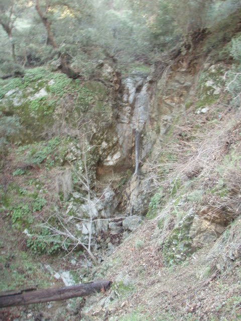
Now this is more like it! as I got to the creek there is a small waterfall about 40ft high and several smaller ones below. There is also the remains of an old stock bridge ! Hah this is it! A faint trail is on the other side off I go.

Image

While faint there was a trail here at one time, it is covered with slides but it is a trail. As I rounded the first ridge there was a wall of brush. Probing it looks like the trail has disappeared but I persisted. I can see signs of the trail in the distance and hack my way through the brush on the line where the trail should be.

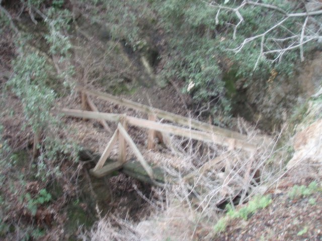
I emerge at a slide... I carefully traverse (don't slip!) and rejoin the faint trail grade. I arrive at the next draw to be greeted by another decrepit stock bridge!

Image

I set up a handline and dropped down to the draw and up the other side leaving my rope behind. Down trees and patches of poison oak block my progress, but persistence wins out as does my Sandivk brush axe, folding saw, and loppers.

I'd resolved to continue until 10am before turning back. My initial mission accomplished, so after hacking my way through a brush and poison oak choked draw I made it to an open area (200) and took a break

A check of my watch indicates 9:55am. I stow the Sandvik and saw and neaten up the path on the way back, when I come back a Pulaski would be good to make those slide areas safer

I get back to my truck and consider the outing a total success!

Wracking my brain for a name for the trail since there is none on the old map I decided on Running Water Trail since Pacoima is according to "California Place Names" by Erwin T Gudde, Pacoima is derived from a Gabrielino- Shoshonean word, and may mean Running Water

Though Maple Cyn trail at one time might be a more accurate name. The trail goes from Bear Divide tp Limekiln Cyn by way of Maple Cyn where some structures are shown on the map. There was no homestead claims filed with the BLM and there are no mines in Maple Cyn or claims in the area

My guess is, and it is a pure unadulterated guess is they are Forest Service permitted recreational cabins , likely revoked when Pacoima Dam was constructed. Again this is pure speculation
User avatar
Dave G
Posts: 321
Joined: Sun Jun 22, 2008 9:51 am

Post by Dave G »

mattmaxon wrote: when I come back a Pulaski would be good to make those slide areas safer
Not many guys have a Pulaski in their tool shed--are you ex-USFS? Fond memories of swinging a Pulaski covered in Foscheck and having it slip out of my hands, nearly dismembering my supervisor :shock: .

Nice TR and forensics.
User avatar
mattmaxon
Posts: 1137
Joined: Mon Mar 24, 2008 12:48 pm

Post by mattmaxon »

Dave G wrote:Not many guys have a Pulaski in their tool shed--are you ex-USFS? Fond memories of swinging a Pulaski covered in Foscheck and having it slip out of my hands, nearly dismembering my supervisor :shock: .

Nice TR and forensics.
Nope nope no Green Shirt here

I've volunteered doing trail maintenance for many many years

I own several Pulaski's and McLeod's, along with rock bars, various mattocks, chain saws, brush saws, grip hoist, & Pionjar 120
User avatar
mve
Posts: 414
Joined: Fri Dec 11, 2009 12:53 pm

Post by mve »

Nice scouting and bushwhacking Matt!
User avatar
mattmaxon
Posts: 1137
Joined: Mon Mar 24, 2008 12:48 pm

Post by mattmaxon »

After going out last Saturday (round two) with 3 others,we made it to the end of the ridge. (inaugural outing for the fabled "Canyoneer Coveralls ®")

The remnants of the old trail petered out as we left the Big Cone Douglas Fir forest, entering 10-15ft high chaparral.

I am hoping to restore access to the area behind the dam for all and want a reasonable trail hike-able by adventurous but non-technical people.

With that in mind where we ended on Saturday didn't fit that requirement. The choss was bad and considerable work would be needed to make it hike-able

I returned for round three on Tuesday after maps where circulated with route suggestions. I headed out about 7:30 am heading down through the plantation. I said "howdy" to two joggers from the fire station. Who seemed surprised to see me, esp. with my bush whacking get up.

I made good time to the point that was selected for the by-pass and found a spot to go up.

I didn't want a dead end trail heading off to nowhere so I didn't establish a "Y" jct but rather when past the point where this bypass would connect with what we'd already done and ascended to where the by-pass would be.

Plenty of brush here but no choss, I plugged along making a shoulder wide path, unsure if this would actually lead where we wanted. Navigating when you can only see 10ft ahead can be difficult but I stayed on the track.

As the route rounded the ridge the brush thinned a bit and lowered to head to shoulder high. There was lots of dead brush also and the mix of plants in the brush changed somewhat making the going easier

I kept saying I was done...just a bit further... but it was getting hot and my water was running low.

I headed back about 11:15 am confident I'd made good progress.

A check of the maps at home shows I got around the bad segment we'd encountered, stopping basically where we'd stopped on round 2, just 160 vertical feet above it.

So I didn't get as far as I thought but made good progress none the less. This always seems to be the case, visions of the terminus of my hike in my head I set out and just don't get what I think I'm gonna do, done.

I figured I'd get to the ridge so I could see into the canyon and get an idea of what lay ahead, oh well Rome wasn't built in a day nor will this.

[RANT]
Time spent locating a good route now will be well spent for the future. Though this route will have one of those things I find maddening. A trail that descends into some area that has parts that ascend.

Many times there is no apparent reason for these segments, but I don't know what the people who laid put the trail encountered off the current route.

Sometimes places where a trail drops or ascend abruptly are the result of poor coordination of separate trail crews. A perfect example of this is the Pacific Crest Trail mile 434.5 down to North Fork Saddle mile 436.5

When the separate groups discovered their trails didn't align, they just connected them as quickly and directly as possible making for abrupt steep unstable segments

Ah well enough trail routing ranting
[/RANT]
Post Reply