
Hi Guys,
Relatively new to the forum, but have been reading up on past posts, and value your collective experience and wisdom. Here's the situation:
Two friends and I, all intermediate or advanced intermediate 3 season hikers and backpackers are looking into giving some winter dayhiking a try.
We'd been planning a BP summit attempt prior to all of this weather, and still would like to give it a try via Vincent Gap in a few weeks on Sun 12/20. We'd all like to have a good trip and return home at night.
My question(s) is/are:
Is this perhaps biting off a bit more than we should chew?
Is this a good snowshoe route?
Crampons/axe? Have them, but if I haven't had formal training, should I leave them for another route?
Any suggestions, opinions, warnings, info, etc would be greatly appreciated. Thanks.
Advice regarding Baden Powell
-
hvydrt
- Posts: 494
- Joined: Thu Sep 27, 2007 8:18 pm
Its hard to say if you are biting of more than you can chew. Its really a personal decision based on conditions and your experiences.
Its not the greatest snowshoe route. If you are looking for a good snowshoe route try the south fork in the San Gorgonio Wilderness or take the tram at San Jacinto State Park. San Jacinto is a good place to start.
Give it a shot. Don't worry about making the top, use good judgment and know when to turn around.
-
Tim

- Posts: 560
- Joined: Tue Apr 08, 2008 8:55 pm
Ditto what hvydrt said. South Fork is nice for snowshoeing because it's not that steep and it's not a narrow trail on the side of a steep slope like most other trails. Round Valley from the PS Tram is also another good place if you don't mind the $22 tram ride, as well as Deer Springs to Suicide Rock if there's enough snow. Usually there are only a couple of opportunities per season to go snowshoeing here because big dumper storms are rare and when they do happen it gets warm afterward and we get these freeze/thaw cycles.
Most of us here probably don't have formal training. We might have learned from friends or on our own. That's what I did, although I sort of want to get training. You can learn most of it from books or youtube and then doing a lot of practice. The main thing, I think, is having good judgment and a much higher level of awareness and respect for the mountain in the winter. I tell my friends that on average every winter SOMEONE WILL DIE. Who's it gonna be? Just make sure it's not you. So watch every step, keep your eyes and ears open, and just generally be more careful. Other than that, it's a beautiful time to be outside!
One tip about crampons: they should have a left and a right, but if not always have your latches on the outside of your legs. Same with your gaiters. This way you won't trip on them.
-
norma r

- Posts: 707
- Joined: Thu Nov 06, 2008 4:22 pm
i agree that the south fork of San G is a beautiful snowshoe route as is San J from the tram. i'm doing the south fork tomorrow. will post conditions.
-
Taco

- Snownado survivor
- Posts: 6125
- Joined: Thu Sep 27, 2007 4:35 pm
Waiting a bit longer for consolidation would mean you can leave the snowshoes behind, and just go with crampons and an axe. Much more enjoyable 99% of the time.
-
mattmaxon

- Posts: 1137
- Joined: Mon Mar 24, 2008 12:48 pm
Depending on the weather the road to Vincent Gulch Divide may be closed at some point from Big Pinesmichaelmagno wrote:try via Vincent Gap in a few weeks on Sun 12/20.
That is a personal question you need to evaluate yourself. Before and during the trip.michaelmagno wrote:My question(s) is/are:
Is this perhaps biting off a bit more than we should chew?
That is a good question? if not why not.michaelmagno wrote:Is this a good snowshoe route?
I for one would have them on hand, there are videos on youtube showing how to use an ice axe for self arrestmichaelmagno wrote:Crampons/axe? Have them, but if I haven't had formal training, should I leave them for another route?
Conditions in the San Gabriel's tend to become icy quickly, ideal conditions for crampons
I'd say if you feel you are out of your league carefully consider what you are doing.michaelmagno wrote:Any suggestions, opinions, warnings, info, etc would be greatly appreciated. Thanks.
Don't become complacent, very experienced people have met their doom on Baden-Powell in the winter
post a TR and photos PLEASE!
-
KathyW
- Posts: 212
- Joined: Thu Sep 27, 2007 9:00 pm
Try these first if you're looking for day trips:
1. South Fork to Dry Lake - a good snowshoe route
2. Tram to Mount San Jacinto - a good snowshoe route
3. Baldy via the Bowl - this one will be a real climb and you'll want that axe and crampons, but the bowl is a great place in the winter to practice snow travel skills.
IMO (and I'm no expert), all of these are safer than Baden-Powell in the winter. Look for a climb with a safe run-out - one that gives you plenty time to arrest before you go off a cliff or hit a tree - You won't have much time to arrest if you take a fall and start sliding on Baden-Powell.
-
EManBevHills

- Posts: 387
- Joined: Fri Sep 28, 2007 12:40 am
My 2 cents:
B-P from Vincent Gap tends to ice up due to its exposure. Because of the many switchbacks -- which can lull you into a false sense of security -- the trail can be deceptively dangerous...
As previously stated, San J and San G are great suggestions. Another good introduction is (surprise) Mt. Pinos. Easy access and gentle, open spaces to enjoy.
Or if the 2 is open to Islip Saddle, you can have a gas along the closed section of ACH to Dawson Saddle.
-
norma r
- Posts: 707
- Joined: Thu Nov 06, 2008 4:22 pm
i second what EManBevHills said about B-P being deceptively dangerous.
Dave G and i played hooky today and snowshoed the South Fork up San Gorgonio. pristine! we broke trail. too tired to post pix tonight, but will tomorrow.
Dave G and i played hooky today and snowshoed the South Fork up San Gorgonio. pristine! we broke trail. too tired to post pix tonight, but will tomorrow.
-
michaelmagno
- Posts: 45
- Joined: Thu Nov 26, 2009 6:11 pm
Thanks all, for the very helpful tid bits of wisdom. Taking it all into consideration and waiting to see what conditions are like closer to launch.
Norma, your pics are eagerly awaited.
Norma, your pics are eagerly awaited.
-
Elwood

- Posts: 620
- Joined: Fri Aug 15, 2008 5:23 pm
As our esteemed colleagues have pointed out, Lord Baden-Powell's namesake can be hit-or-miss, depending on accumulated precipitation and subsequent weather conditions.
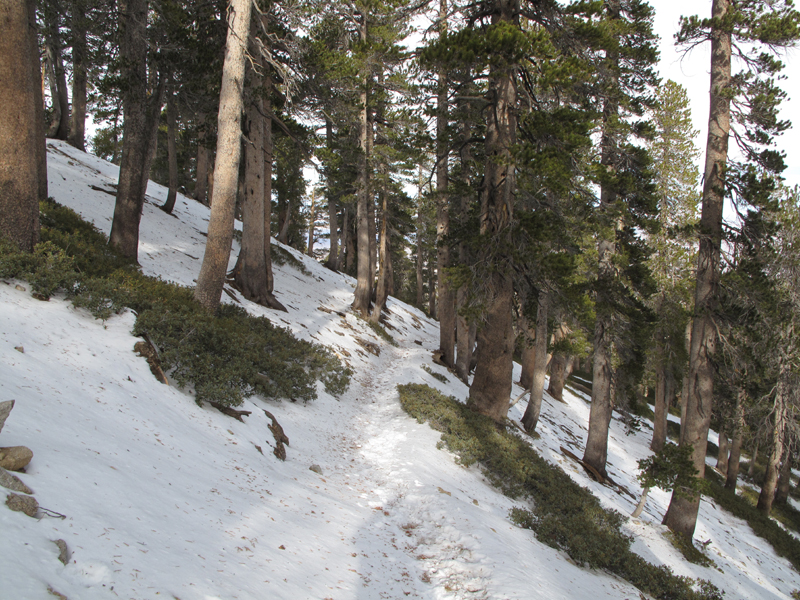
"Worst" of the trail conditions this past Saturday.
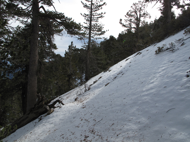
Adjacent slope, and a good indication of what the trail looks like after a good storm. Keep in mind that this could be loose powder or hard ice.
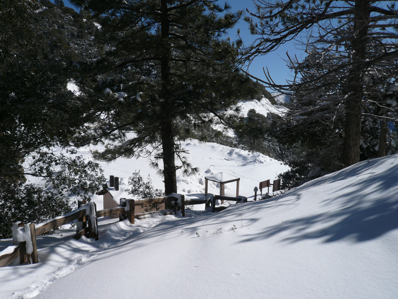
Baden-Powell PCT trailhead on February 14th of this year.
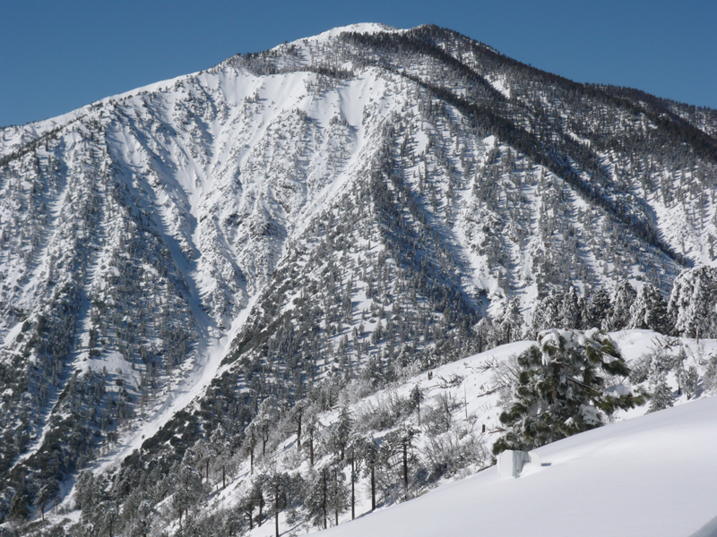
B-P in its snow-capped glory on the same day. Also note that the Crest Highway was closed at Grassy Hollow and that tire chains were required to get there.
"Worst" of the trail conditions this past Saturday.
Adjacent slope, and a good indication of what the trail looks like after a good storm. Keep in mind that this could be loose powder or hard ice.
Baden-Powell PCT trailhead on February 14th of this year.
B-P in its snow-capped glory on the same day. Also note that the Crest Highway was closed at Grassy Hollow and that tire chains were required to get there.

-
Taco
- Snownado survivor
- Posts: 6125
- Joined: Thu Sep 27, 2007 4:35 pm
Hope you don't mind that I stole your photo, Elwood. 8)
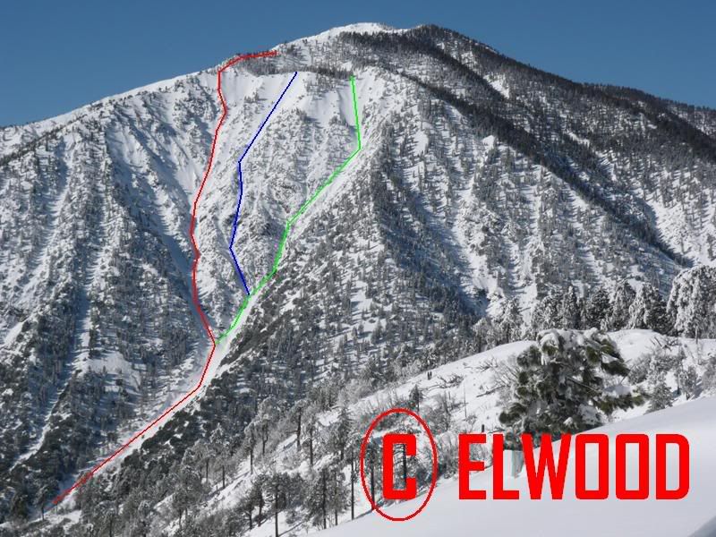
-Red is Boulderdash
-Green is the right mixed couloir (did not go up past first mixed step/waterfall) (want to try this this month)
-Blue is a line I just plotted now that would be mixed to a nice easy bowl of sorts, terminating at the east flat, east of the summit.
Boulderdash is an awesome climb. 2nd favorite climb in the SG's.
http://www.summitpost.org/route/372697/ ... 4-AI2.html
-
Elwood
- Posts: 620
- Joined: Fri Aug 15, 2008 5:23 pm
Hey Taco,
Any picture I post is fair game. No attribution necessary.
-Elwood
Any picture I post is fair game. No attribution necessary.
-Elwood
-
Zach

- Posts: 522
- Joined: Sun Jan 04, 2009 4:25 pm
those lines look sick! holy cow when are you guys going out?!
-
Taco
- Snownado survivor
- Posts: 6125
- Joined: Thu Sep 27, 2007 4:35 pm
Zach, depends on how Icehouse feels on sunday. If it is consolidated enough, I might head up Boulderdash during the week, and might camp out and also do one of the other ones, like completing the green line. Lemme know if you're interested.