What peak is this?

Trip planning, history, announcements, books, movies, opinions, etc.
Post Reply
User avatar
Sam Page
Posts: 267
Joined: Fri Sep 04, 2009 10:59 am

Post by Sam Page »

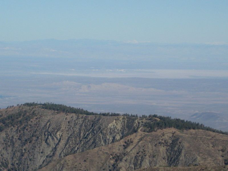
From the summit of Mt. Baldy, the snowy Sierras can be seen far to the north, as in this picture:

Image

There are two clusters of snowy peaks in the distance. I assume that the peaks on the right are the Whitney/Langley group. But what is that snowy peak on the left (which is actually in the top center of the photo)?
User avatar
edenooch
Posts: 504
Joined: Fri Jul 03, 2009 7:42 pm

Post by edenooch »

olancha? tehachapi?
User avatar
moppychris
Posts: 87
Joined: Mon Sep 07, 2009 12:56 pm

Post by moppychris »

Is this a recent picture? Are the Sierras that covered in snow yet? I imagine that there is snow on peaks but not enough to actually cover them like that. My mate lives in Tahoe and sends pictures to me of the peaks around there, and they don't have any snow on them, higher latitude at around 11,000ft.
I think those could just be clouds over the mountains. But I have no 20/20 vision.
Tahachipe would be a good guess.
User avatar
Ze Hiker
Posts: 1430
Joined: Mon Jul 28, 2008 7:14 pm

Post by Ze Hiker »

too far for tehachapis. plus they are lower elevation, only high altitude stuff would have that much snow.
User avatar
Sam Page
Posts: 267
Joined: Fri Sep 04, 2009 10:59 am

Post by Sam Page »

moppychris wrote:Is this a recent picture? Are the Sierras that covered in snow yet?
The photo was taken about three weeks ago, but I saw the same view again this past Sunday.
User avatar
Taco
Snownado survivor
Posts: 6010
Joined: Thu Sep 27, 2007 4:35 pm

Post by Taco »

Don't think it's the Kaweah group?
User avatar
Sam Page
Posts: 267
Joined: Fri Sep 04, 2009 10:59 am

Post by Sam Page »

TacoDelRio wrote:Don't think it's the Kaweah group?
Yes. Someone at summitpost made a compelling case that it's the Kaweah group.
User avatar
Taco
Snownado survivor
Posts: 6010
Joined: Thu Sep 27, 2007 4:35 pm

Post by Taco »

Saw that. :lol:

Looks like it could very well be, having been in your position before wondering what's what out there.
User avatar
HikeUp
Posts: 3861
Joined: Thu Sep 27, 2007 9:21 pm

Post by HikeUp »

Did you take a bearing on it? That would support/debunk the case for the Kaweahs.
User avatar
norma r
Posts: 707
Joined: Thu Nov 06, 2008 4:22 pm

Post by norma r »

DaddyLongLegs wrote:
TacoDelRio wrote:Don't think it's the Kaweah group?
Yes. Someone at summitpost made a compelling case that it's the Kaweah group.
that's fascinating!! :D cool thread.
User avatar
canoeman
Posts: 60
Joined: Wed Jul 08, 2009 1:04 am

Post by canoeman »

thats edwards air base in the background
so its north east of edwards
looking from about about 310 degrees from edwards
i think
User avatar
canoeman
Posts: 60
Joined: Wed Jul 08, 2009 1:04 am

Post by canoeman »

table mountain wrightwood
User avatar
canoeman
Posts: 60
Joined: Wed Jul 08, 2009 1:04 am

Post by canoeman »

wright mountain?
User avatar
canoeman
Posts: 60
Joined: Wed Jul 08, 2009 1:04 am

Post by canoeman »

I was drinkin beer never read the whole post thought you were referring to the peak in the foreground
sorry
User avatar
canoeman
Posts: 60
Joined: Wed Jul 08, 2009 1:04 am

Post by canoeman »

Oh think Whitney is on the left the white mountains on the right.
maybe?
this is almost the same view from my house.
I'm at 5000 ft in juniper hills on pleasant view ridge.

canoeman
Post Reply