The Station Fire Thread

Rescues, fires, weather, roads, trails, water, etc.
User avatar
cougarmagic
Posts: 1409
Joined: Wed May 07, 2008 5:21 pm

Post by cougarmagic »

This blog has good information:

http://www.altadenablog.com/
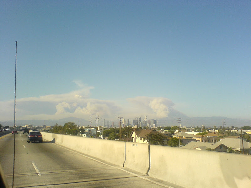
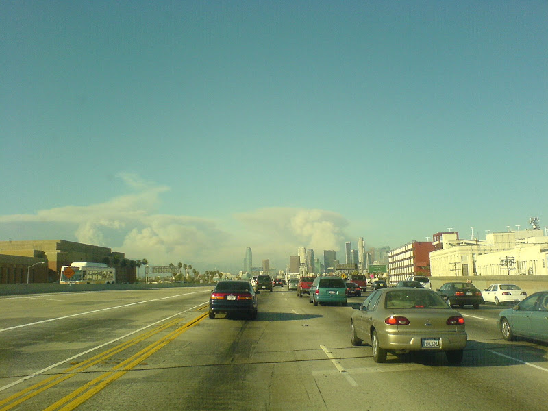
UPDATE 1:30: Mt. WIlson: Apparently now there is growing concern that the critical communications towers on Mt. Wilson may be endangered. In a note to the "neighbors" usegroup, Steve Bass reports that there is only one engineer now on the hill taking care of all stations. Upper Big Tujunga Rd. is no longer usable for egress due to a fire 300 yards from Colby Ranch on Upper Big Tujunga. The only safe way out now is through Wrightwood.
User avatar
mattmaxon
Posts: 1137
Joined: Mon Mar 24, 2008 12:48 pm

Post by mattmaxon »

http://www.youtube.com/watch?v=k5Kxun2MvEQ

This was still processing @ 3:02pm
User avatar
Ze Hiker
Posts: 1430
Joined: Mon Jul 28, 2008 7:14 pm

Post by Ze Hiker »

via cell phone on the 110

Image


Image

Image
User avatar
AlanK
Posts: 1069
Joined: Thu Sep 27, 2007 9:28 pm

Post by AlanK »

I added more local pictures today.
User avatar
Kit Fox
Posts: 152
Joined: Tue Dec 25, 2007 11:33 am

Post by Kit Fox »

Matt,

It looks like your "Sugarbush" geocache was right in the middle of this fire.
User avatar
mattmaxon
Posts: 1137
Joined: Mon Mar 24, 2008 12:48 pm

Post by mattmaxon »

Yeah, that's "toast" as are my tools on Stone Cyn Trail

Hopefully my friends house isn't one of the 3-5 lost in Big Tujunga :(
User avatar
robnokshus
Posts: 130
Joined: Fri Apr 04, 2008 7:25 am

Post by robnokshus »

Here's a link to a thread on what's going on up at Mt. Wilson:

http://boards.radio-info.com/smf/index. ... c=151865.0
User avatar
cougarmagic
Posts: 1409
Joined: Wed May 07, 2008 5:21 pm

Post by cougarmagic »

mattmaxon wrote:Hopefully my friends house isn't one of the 3-5 lost in Big Tujunga :(
Some good news - Jane has heard her house is still there!

The other homes in the canyon...not so much....
User avatar
mattmaxon
Posts: 1137
Joined: Mon Mar 24, 2008 12:48 pm

Post by mattmaxon »

cougarmagic wrote:
mattmaxon wrote:Hopefully my friends house isn't one of the 3-5 lost in Big Tujunga :(
Some good news - Jane has heard her house is still there!

The other homes in the canyon...not so much....
Yeah
talked with'em

Definitely too bad about the others 10 on the south side of the river

Some of the other canyon residents went to our fearless leaders news conference at Hansen Dam and held his feet to the fire

apparently he got some answers

The unofficial figure I've heard is 30
User avatar
mattmaxon
Posts: 1137
Joined: Mon Mar 24, 2008 12:48 pm

Post by mattmaxon »

After watching this fire for some time now it has become readily apparent the fire fighting strategy is to not fight it

They let all of Yerba Buena Ridge burn to Riverwood ranch burn before trying to do anything

Haines Cyn and Pipe Cyn are now burning. Zero effort to fight it

All they are doing is structure protection

Very disheartening

They might as well go back to the station house and clock out if they are going to stand around and watch
User avatar
simonov
Posts: 1087
Joined: Tue Nov 27, 2007 5:44 pm
Location: Reno, NV
Contact:

Post by simonov »

It hasn't burned since the 1950s. They probably reckon it's high time. And it's not a bad time to let the burning happen, since there are only light winds.

I saw a report somewhere today that they anticipate containment a week from Tuesday.
Nunc est bibendum
User avatar
mattmaxon
Posts: 1137
Joined: Mon Mar 24, 2008 12:48 pm

Post by mattmaxon »

The RED areas are the most currently actively burning areas

Yeah sure let the whole thing burn... Most of it hasn't burned in a while

Just another prime example of Forest Service mismanagement

As I've always said, some of the worst things done to the Angeles has been at the hands of the FS Policies and their stupidity, from the Git Go to now.

Ranching, Mining, Timber Sales, Road Building, Homesteading, you name it

Image
User avatar
outwhere
Posts: 323
Joined: Sun Jan 25, 2009 5:40 pm

Post by outwhere »

Just got these two sentences inna email blast, the first one about 5:15, the second one, about 15 minutes later:

"As of now, there are visible flames on the front side of Sunset Ridge, NNW of Echo."

"Bad news. The Cape is burning."

---

That being 'The Cape of Good Hope' from the Mount Lowe railway fame...

:cry: :cry: :cry:
User avatar
cougarmagic
Posts: 1409
Joined: Wed May 07, 2008 5:21 pm

Post by cougarmagic »

And so goes the pavilion at Inspiration Point, which the Mt Lowe volunteers worked so hard to rebuild, and make historically accurate:

http://www.mtlowe.net/pavillion.htm
User avatar
outwhere
Posts: 323
Joined: Sun Jan 25, 2009 5:40 pm

Post by outwhere »

cougarmagic wrote:And so goes the pavilion at Inspiration Point, which the Mt Lowe volunteers worked so hard to rebuild, and make historically accurate:

http://www.mtlowe.net/pavillion.htm
Cougarmagic, is that [reasonable] speculation or have you heard that the pavilion has or is burning?

Just read this from the SG Valley Tribune:

....... Los Angeles County Fire Department Capt. Mark Savage said a strike team and engines were in place and air tankers had laid down fire retardant on the mountain directly in front of the “huge communication location.”

“It’s not a matter of if it impacts Mt. Wilson, it’s a matter of when,” he said. “Unfortunately today it was so smoky that our tankers couldn’t work anywhere near that area......

----

Yikes...

Does anyone know if the fire has gone up the Grand Canyon, just west of where the Alpine Tavern once stood?

Always wanted to get down in there... sure looked pretty when looking down on it from the Granite Gate area...
User avatar
cougarmagic
Posts: 1409
Joined: Wed May 07, 2008 5:21 pm

Post by cougarmagic »

outwhere wrote:Cougarmagic, is that [reasonable] speculation or have you heard that the pavilion has or is burning?
Speculation - but the thing is made entirely of wood...so...
User avatar
HikeUp
Posts: 3861
Joined: Thu Sep 27, 2007 9:21 pm

Post by HikeUp »

I holding out hope that it's still there...
Image
User avatar
outwhere
Posts: 323
Joined: Sun Jan 25, 2009 5:40 pm

Post by outwhere »

Oh, now that I look a bit closer at the map provided by mattmaxon, looks like most of Mt. Lowe Railway area has been burned to some degree.

Is it safe to say that those areas shaded in the orangish/peachish color are areas that have already burned?

And if so, is it also safe to assume that burned means, nothing left but ash?

Damn, that would be sad, that area around Granite Gate was gorgeous.
:cry: :cry: :cry:
User avatar
cougarmagic
Posts: 1409
Joined: Wed May 07, 2008 5:21 pm

Post by cougarmagic »

I just got this email from Brian Marcroft, who runs the Mt Lowe volunteers:

"Fire at cape and circular bridge. they were fighting another fire at sunset point near granite gate. It appears that they stopped the fire in millard at about granite gate"

Maybe those beautiful pines near the camp are OK.
User avatar
Hikin_Jim
Posts: 4686
Joined: Thu Sep 27, 2007 9:04 pm

Post by Hikin_Jim »

HPS peaks in closed area in and around the Station Fire:
09A Mount Gleason (in the burn perimeter)
09B Iron Mountain #2 (in the burn perimeter)
09C Condor Peak (in the burn perimeter)
09D Fox Mountain #2 (in the burn perimeter)
09E Mount Lukens (in the burn perimeter)
10A Mount Emma
10B Old Mount Emma
10C Pacifico Mountain
10D Bare Mountain
10E Granite Mountain #1
10F Rabbit Peak #1 (in or at the edge of the burn perimeter)
10G Iron Mountain #3
10H Round Top
10I Mount Hillyer
10J Cole Point
11A Josephine Peak (in the burn perimeter)
11B Strawberry Peak (in or at the edge of the burn perimeter)
11C Mount Lawlor
11D Barley Flats
11F Vetter Mountain (LO)
12A Mount Deception (in the burn perimeter)
12B Mount Disappointment (in or at the edge of the burn perimeter)
12C San Gabriel Peak (in or at the edge of the burn perimeter)
12D Mount Markham (in the burn perimeter)
12E Mount Lowe (in the burn perimeter)
12F Occidental Peak
12G Mount Wilson
15A Monrovia Peak
User avatar
Hikin_Jim
Posts: 4686
Joined: Thu Sep 27, 2007 9:04 pm

Post by Hikin_Jim »

mattmaxon wrote:My friends who live at la paloma flat where evacuated with flames within ¼ mile

I drove from Big-T Rd to La Cresenta (Ocean View Blvd)

Fire down into Hall-Beckley Canyon to at least 2900ft level

Probably lower from what I could see, but to there for sure

The south Side of Mt Lukens has fire in the Head of Haines Canyon

The North face of Mt Lukens from Grizzly Flat to probably Delta Cyn is in flames

The fire has jumped Big-T rd @ Stony Vale and is making a run for Condor Peak

Mandatory evacuations for Colby Ranch area too....
Dang. Hatin' it.

My mom was evac'd from Briggs Terrace yesterday. House is still there as of this afternoon. A lot of fuel still left in the Pickens Canyon area.

Haines Canyon burning? Crap. Nice stretch of trees in the head of the canyon. :(
User avatar
HikeUp
Posts: 3861
Joined: Thu Sep 27, 2007 9:21 pm

Post by HikeUp »

Inspiration Point is still standing as of 7:00 pm Sunday night. :D

My 12x zoom on a point and shoot can't pick it up clearly, but through my binoculars I was able to clearly see it standing proud still (full size)
Image

I saw rather large flames on Mt. Lowes SSW flanks.

I took picture from corner of Santa Rosa Ave and Poppyfields Dr (NW of Altadena and Lake a block or two).
User avatar
Mike P
Posts: 1005
Joined: Tue Oct 02, 2007 10:48 pm

Post by Mike P »

mattmaxon wrote:After watching this fire for some time now it has become readily apparent the fire fighting strategy is to not fight it

They let all of Yerba Buena Ridge burn to Riverwood ranch burn before trying to do anything

Haines Cyn and Pipe Cyn are now burning. Zero effort to fight it

All they are doing is structure protection

Very disheartening

They might as well go back to the station house and clock out if they are going to stand around and watch
Hmmm... maybe the fire guys know something about the dangers of this fire. Do you think it is worth putting boots on the ground and have them injured or killed trying to save decades-old chaparral? Some of the areas you mentioned are difficult to get to.
User avatar
Hikin_Jim
Posts: 4686
Joined: Thu Sep 27, 2007 9:04 pm

Post by Hikin_Jim »

HikeUp wrote:I saw rather large flames on Mt. Lowes SSW flanks.
Oh, yeah; you've got that right.
User avatar
Mike P
Posts: 1005
Joined: Tue Oct 02, 2007 10:48 pm

Post by Mike P »

Dang it! Too late about firefighter deaths. Two were killed today... reportedly on Mount Wilson:

http://cbs2.com/firewatch/Fire.Watch.An ... 52524.html

Hopefully, this is just misinformation from the fire truck rollover near Mt Gleason.
User avatar
HikeUp
Posts: 3861
Joined: Thu Sep 27, 2007 9:21 pm

Post by HikeUp »

Hikin_Jim wrote:
HikeUp wrote:I saw rather large flames on Mt. Lowes SSW flanks.
Oh, yeah; you've got that right.
I mean within a hundred feet of the peak or so, directly behind Inspiration Point in my picture (if it was at all in focus)!!! I need a digital SLR!!! Argh!

Anyway, it either came up Grand Cyn. to that point or is spilling over southward from Bear Cyn. and trying to get into the Eaton Cyn watershed. Looks like the entire Arroyo Seco watershed is toast except (maybe, hopefully) upper part of Grand Cyn.
User avatar
HikeUp
Posts: 3861
Joined: Thu Sep 27, 2007 9:21 pm

Post by HikeUp »

Mike P wrote:Dang it! Too late about firefighter deaths. Two were killed today... reportedly on Mount Wilson:

http://cbs2.com/firewatch/Fire.Watch.An ... 52524.html
1070 was reporting a 'rig' turnover on Mt. Gleason sometime in the 6 o'clock hour tonight.
User avatar
Hikin_Jim
Posts: 4686
Joined: Thu Sep 27, 2007 9:04 pm

Post by Hikin_Jim »

HikeUp wrote:
Hikin_Jim wrote:
HikeUp wrote:I saw rather large flames on Mt. Lowes SSW flanks.
Oh, yeah; you've got that right.
I mean within a hundred feet of the peak or so, directly behind Inspiration Point in my picture (if it was at all in focus)!!! I need a digital SLR!!! Argh!

Anyway, it either came up Grand Cyn. to that point or is spilling over southward from Bear Cyn. and trying to get into the Eaton Cyn watershed. Looks like the entire Arroyo Seco watershed is toast except (maybe, hopefully) upper part of Grand Cyn.
So, sounds like Switzers and Bear Canyon are pretty much toast? Crap.
User avatar
HikeUp
Posts: 3861
Joined: Thu Sep 27, 2007 9:21 pm

Post by HikeUp »

Hikin_Jim wrote:My mom was evac'd from Briggs Terrace yesterday. House is still there as of this afternoon.
Good to hear HJ! I have a few friends in the same general area that had to be evac'd too. Not fun.
User avatar
Mike P
Posts: 1005
Joined: Tue Oct 02, 2007 10:48 pm

Post by Mike P »

I suspect the Angeles Crest 100 will be no-go on Sept 19 as much of the lower trail (Prieto, Millard, Sam Merrill) is gone. I work the Newcomb Saddle Aid Station. I'm hoping it is still there in the morning.
Post Reply