Red Rock Mine (fail) but still a great adventure.

TRs for ranges in California.
Post Reply
User avatar
Kit Fox
Posts: 152
Joined: Tue Dec 25, 2007 11:33 am

Post by Kit Fox »

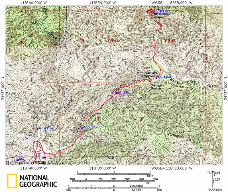
I was hoping to visit the old mine mentioned in The Search for Redrock Canyon – a lost Shangri-la. Having never visited the area, and not knowing what the water situation would be, I prepared for the worst case scenario. I carried full survival gear, couples days worth of food, 3 gallons of water, and an ammo can. Just my luck there was water in many places. :roll:


I made it to the Pianobox Prospect which is 4.5 miles from my vehicle. At this point, I had lunch, and then decided to give Red Rock mtn a try. This is the peak you have to climb over, just to get to the mine. A combination of high humidity, and not being used to carrying such a heavy load, took its toll me. I started up the trail, at hit a wall and called it a day. This was the same moment I discovered that my 3/4 gallon canteen had sprung a leak, and filled by backpack with water. :evil: Fortunately I keep everything in waterproof sacks. :)

I decided to call it a day and head home. I took a few pictures if your interested.


Image

Image


Image


My Fish Canyon Series.

My PianoBox Prospect Series
User avatar
Taco
Snownado survivor
Posts: 6037
Joined: Thu Sep 27, 2007 4:35 pm

Post by Taco »

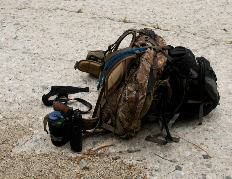
Nice Ruger Redhawk. 8)
User avatar
Ze Hiker
Posts: 1432
Joined: Mon Jul 28, 2008 7:14 pm

Post by Ze Hiker »

well, great attempt even if you didn't make it.

how was the terrain? what would most likely deter you from getting to the mine? steep terrain, bad brush, etc...?
User avatar
Kit Fox
Posts: 152
Joined: Tue Dec 25, 2007 11:33 am

Post by Kit Fox »

TacoDelRio wrote:Nice Ruger Redhawk. 8)
Thanks, but it is actually a GP100 .357 :wink:
User avatar
Kit Fox
Posts: 152
Joined: Tue Dec 25, 2007 11:33 am

Post by Kit Fox »

wrote:well, great attempt even if you didn't make it.

how was the terrain? what would most likely deter you from getting to the mine? steep terrain, bad brush, etc...?
The terrain to the base of the mountain is a cake walk, my problem was the load on my back. I'm not used to carrying a 60 pounds plus backpack for long distances. The beginning of the trail to the summit of Red Rock Mtn, is heavily overgrown with Yuccas, Chaparral, and at the beginning, you have to do a "dance around" Poison Oak. Some pruners are in order.

Had the climb to the summit started at the beginning of the hike, I think I could have made it to the mine. My goal was to summit the peak, then drop water at several strategic points. I plan on making one or two additional "pre-trips" just to bury water. I had know way of knowing that the streams would be flowing so well at the base of Red Rock Mtn.

If I would have known in advance, I would have carried one 3L bladder to drink along my hike, then fill the rest using my Katadyn, before hiking to the top. Another down side is the desert / chaparral climate. The day I chose had a high of 84, but thanks to heavy cloud cover, the humidity was the pits. I can't remember sweating that hard before. Until you climb the summit of Red Rock Mtn., most of the day is spent below 2000 feet elevation.


The positive side to the hike was no crowd, no diapers, and only a few spots with spray paint damage (most being well faded out). I saw two people (both backpackers) the entire day.

I may make it an overnighter next time.
User avatar
Hikin_Jim
Posts: 4686
Joined: Thu Sep 27, 2007 9:04 pm

Post by Hikin_Jim »

When you said "Pianobox" that rang a bell for me. Years and years ago (maybe when I was in Jr. High -- 70's), my dad, my uncle, and I did a loop out to the Gillette Mine from Cienaga Campground through Pianobox to the Gillette Mine Trail to the mine itself, and then returning via Bear, Cienga, and Redrock Canyons.

Here's a map of our route. You'll need to scroll around and zoom in to make any sense out of the map.
A = Cienaga CG
B = Pianobox
C = Windy spot in Fish Canyon
D = Jct with Burnt Pk Trail (actually, I marked this one confluence South of true jct)
E = Jct with Gillette Mine Trail
F = Gillette Mine
G = Confluence of Bear and Cienaga Canyons
H = Exit point out of Cienaga Canyon
I = Pt. on route to Redrock Canyon
J = Jct with trail back to Pianobox (our intended route)
K & L = points along our intended return route to Pianobox
M = Actual return route down Redrock Can.
N = Approx. loc of trailhead in Redrock Can.

It was a long hike. I remember being impressed that there were pines and such back in and not just chapparal. We did finally get to the mine area, but we were running way late. To complicate matters, the routes down Bear, Cienaga, and Redrock canyon were in poor shape. There had been a lot of rain recently, and there were a lot of water crossings which were difficult in the dark. We opted not to take the trail back to Pianobox since it was dark and continued down Redrock Canyon to the trailhead where we hitched a ride back to our car at Cienaga CG. We got back to the car at about 1:00 A.M. give or take. It was a long hike and a real test of endurance and perserverance. Oddly enough, I do remember some of the nice things like pine trees and scenery. Odder still, I still remember our route.

I have no idea what the trails would be like back there now, 30 or so years later. That part of the forest has never gotten the kind of hiking traffic that the main section does.

QUESTION: Is the "Redrock Mine" you were talking about one and the same as the "Gillette Mine" marked on the map or is it another mine? If so, can you plot it on an Acme map and post it here on the forum? I'm just curious.
User avatar
Kit Fox
Posts: 152
Joined: Tue Dec 25, 2007 11:33 am

Post by Kit Fox »

Hikin_Jim wrote:When you said "Pianobox" that rang a bell for me. Years and years ago (maybe when I was in Jr. High -- 70's), my dad, my uncle, and I did a loop out to the Gillette Mine from Cienaga Campground through Pianobox to the Gillette Mine Trail to the mine itself, and then returning via Bear, Cienga, and Redrock Canyons.

I have no idea what the trails would be like back there now, 30 or so years later. That part of the forest has never gotten the kind of hiking traffic that the main section does.

QUESTION: Is the "Redrock Mine" you were talking about one and the same as the "Gillette Mine" marked on the map or is it another mine? If so, can you plot it on an Acme map and post it here on the forum? I'm just curious.
No this is a different mine. http://www.lagoldmines.com/index.php?page=356299.txt

Image

Most of Redrock Canyon is now choked in thick brush, and a sea of Poison Oak. I actually had considered continuing Northwest towards Roger's Camp, but the owner of the geocache mentioned habitation by persons unknown. The first finder of the geocache mentioned seeing supplies which included gardening tools, and old drip line. This strikes me as a remote Marijuana grow. The last person filed a report with LASD. I really didn't want to tangle with dope growers by myself, especially with a wife and two kids at home who depend on me.
User avatar
EnFuego
Posts: 677
Joined: Mon Dec 15, 2008 11:14 am

Post by EnFuego »

Looked like apretty nice excursion. And wow!!! 3 gallons of water.

Side question - are you allowed to carry a firearm in the Angeles?
User avatar
Hikin_Jim
Posts: 4686
Joined: Thu Sep 27, 2007 9:04 pm

Post by Hikin_Jim »

KF:

OK, gotcha. I re-read Blanchard's write up and realized that we were talking about two different mines. I note that in Blanchard's writings, he mentions that there was nothing much to be found in the Gillette Mine area. That jibes with my memory of the area.

I had no idea how fortunate we were to just drive right up to Cienaga CG back in the day. My dad describes driving his old Ford on back roads in what is now the Sespe Condor Refuge. Interesting days.

It is a great shame that Mr. Blanchard passed away recently in what appeared to be some type of hiking accident. His website is the most informative I've ever seen. I hope the pages remain up for some time even though their author is now sadly gone. Perhaps I should arhcive the html and images lest they be lost.

That sounds like some really tough terrain, KF. I think "fail" should be removed from your TR. Just getting back there is "win" in my book.

HJ
User avatar
Kit Fox
Posts: 152
Joined: Tue Dec 25, 2007 11:33 am

Post by Kit Fox »

EnFuego wrote:Looked like apretty nice excursion. And wow!!! 3 gallons of water.

Side question - are you allowed to carry a firearm in the Angeles?

As a hunter yes. I have a valid California hunting license, and Coyotes season is all year long :mrgreen: . The only thing I had to do is comply with the new lead ban by carrying "lead free" ammo.
User avatar
Hikin_Jim
Posts: 4686
Joined: Thu Sep 27, 2007 9:04 pm

Post by Hikin_Jim »

Kit Fox wrote:
EnFuego wrote:Looked like apretty nice excursion. And wow!!! 3 gallons of water.

Side question - are you allowed to carry a firearm in the Angeles?

As a hunter yes. I have a valid California hunting license, and Coyotes season is all year long :mrgreen: . The only thing I had to do is comply with the new lead ban by carrying "lead free" ammo.
There's a lead ban now? Entire state? LA County only? Angeles NF? Or ??
User avatar
Kit Fox
Posts: 152
Joined: Tue Dec 25, 2007 11:33 am

Post by Kit Fox »

A good portion of the state is now lead free. A 20 round box of .357 cost me over $30.00 bucks. One box of lead free ammo for my 7mm was $63.00 bucks :evil:

http://www.dfg.ca.gov/wildlife/hunting/ ... ionAct.pdf
User avatar
Hikin_Jim
Posts: 4686
Joined: Thu Sep 27, 2007 9:04 pm

Post by Hikin_Jim »

Interesting. Looks like all of the Angeles and Los Padres Forests are included and at least part of the San Berdoos. Looks like San Jacs are out of the non-lead area.

Haven't done much shooting in the last 10 years. Intersting to know the current developments.
User avatar
Kit Fox
Posts: 152
Joined: Tue Dec 25, 2007 11:33 am

Post by Kit Fox »

This only applies to hunting so far. Recreational shooting hasn't been restricted yet.


Are those old trails you mentioned (and still visible via the maps) available in old books?
User avatar
Hikin_Jim
Posts: 4686
Joined: Thu Sep 27, 2007 9:04 pm

Post by Hikin_Jim »

I imagine that they would be. I believe my uncle picked that route out of a guide book, but God alone would know which one. Both my dad and my uncle have gone to meet their maker. I may look in some of my books tonight if I get a chance.
User avatar
Kit Fox
Posts: 152
Joined: Tue Dec 25, 2007 11:33 am

Post by Kit Fox »

I found it by viewing Trails of the Angeles By John W. Robinson, John Robinson, Doug Christiansen, Doug Christiansen on Google books.
User avatar
Hikin_Jim
Posts: 4686
Joined: Thu Sep 27, 2007 9:04 pm

Post by Hikin_Jim »

Interesting. So that was a 24 mile loop we were attempting -- although I suppose it would have been a bit shorter since you could drive in farther back then. Still a pretty good trek. Another spot I'll have to back into that I haven't been to in a long time.

I've got an older copy of Trls of the Angls at home from the 80's. I'll have to compare the write ups.

Shame that those trails have been let go. If I ever get a week off, my loppers and I will have to take a walk... :)

HJ
User avatar
Kit Fox
Posts: 152
Joined: Tue Dec 25, 2007 11:33 am

Post by Kit Fox »

Hikin_Jim wrote:Interesting. So that was a 24 mile loop we were attempting -- although I suppose it would have been a bit shorter since you could drive in farther back then. Still a pretty good trek. Another spot I'll have to back into that I haven't been to in a long time.

I've got an older copy of Trls of the Angls at home from the 80's. I'll have to compare the write ups.

Shame that those trails have been let go. If I ever get a week off, my loppers and I will have to take a walk... :)

HJ
It would be a blast if we could organize a group effort to re-establish those trails.
User avatar
HikeUp
Posts: 3932
Joined: Thu Sep 27, 2007 9:21 pm

Post by HikeUp »

Giddy up!
Image
User avatar
kgw
Posts: 133
Joined: Fri Jul 18, 2008 11:48 am

Post by kgw »

Where is that fish canyon site? Looks interesting. . .
User avatar
Taco
Snownado survivor
Posts: 6037
Joined: Thu Sep 27, 2007 4:35 pm

Post by Taco »

Kit Fox wrote:
TacoDelRio wrote:Nice Ruger Redhawk. 8)
Thanks, but it is actually a GP100 .357 :wink:
Damn, it's been too long. :lol:
User avatar
Hikin_Jim
Posts: 4686
Joined: Thu Sep 27, 2007 9:04 pm

Post by Hikin_Jim »

kgw wrote:Where is that fish canyon site? Looks interesting. . .
Near Castaic Lake.
User avatar
Richard N.
Posts: 91
Joined: Tue Feb 12, 2008 9:47 pm

Post by Richard N. »

You can start from either end of Warm Spring Truck Trail.
On the east off of Lake Hughes Road and from the west at the end of Templin Highway.
You can mountain bike in for a fast way back down or you can take my way and drive in.
Oh wait, you don't have keys. :cry:
The east end has been repaired so driving in is easy.
I've driven to Cienaga to do habitat work.
The camp is decommissioned but its all there.
Seen a lot of hunters in there as well. Where they get keys is anyone guess.
I'm hoping to get up there latter in the fall. It can get pretty hot this time of the year.
I recommend taking a trip to Warm Springs Lookout. Its a great view from up there.

Oh yea, if you hike up there, don't bring your kids.
How someone would even think of that is beyond me but they do.
Post Reply